

National Park · Kanchanaburi
Thong Pha Phum National Park
อุทยานแห่งชาติทองผาภูมิ
Mountain Wilderness, Misty Forests & the Ridge of Khao Chang Phueak
Thong Pha Phum · Sangkhla Buri · Western Thailand
Where the Tanaosri Range runs toward Myanmar, forest, waterfalls and a famous ridge open a wilder, higher, quieter side of Kanchanaburi.
A Wilderness on the Western Border
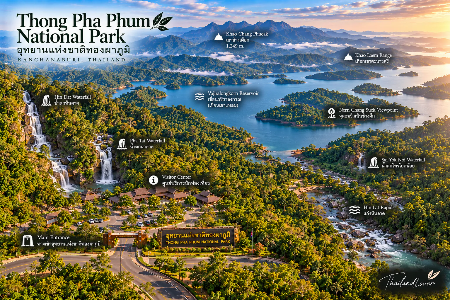
Far in the mountains of western Kanchanaburi, where the Tanaosri Mountain Range stretches toward the Myanmar border, lies Thong Pha Phum National Park (อุทยานแห่งชาติทองผาภูมิ) — one of Thailand’s great wilderness landscapes.
This is a national park of steep mountains, deep forest, waterfalls, remote valleys and highland grasslands. Its highest summit, Khao Chang Phueak, rises to 1,249 metres. From the ridge trail, the landscape opens into an immense panorama of mountains and forest.
Thong Pha Phum is not only about one mountain. Its forests are part of Thailand’s Western Forest Complex, one of the country’s most important remaining forest landscapes. The park protects watersheds, provides habitat for large mammals and connects with other major protected areas along the western border.
Wilder. Higher. Quieter. More remote.
At a Glance
- 1,249 m
- Khao Chang Phueak — the highest point in the park.
- No. 114
- Established 23 December 2009.
- 1,235.54 km²
- Official area — 772,214.27 rai.
- Tanaosri
- The mountain range running toward Myanmar.
- Western Forest
- Connected habitat for elephants and large mammals.
- Official Name
- Thong Pha Phum National Park
- Thai Name
- อุทยานแห่งชาติทองผาภูมิ
- Province
- Kanchanaburi
- Districts
- Thong Pha Phum and Sangkhla Buri
- National Park No.
- 114
- Established
- 23 December 2009
- Official Area
- 772,214.27 rai / 1,235.54 km²
- Mountain Range
- Tanaosri Range
- Highest Point
- Khao Chang Phueak — 1,249 m
- Border
- Myanmar
- Main Landscape
- Mountain forest, evergreen forest, mixed deciduous forest, streams, waterfalls and highland grassland
- Famous For
- Khao Chang Phueak, Chok Kradin Waterfall, Pha Pae Waterfall, Chet Mit Waterfall and mountain viewpoints
- Best For
- Hiking, camping, waterfalls, photography, wildlife and mountain scenery
Thong Pha Phum National Park was officially established on 23 December 2009 as Thailand’s 114th national park. The Department of National Parks lists its area as approximately 772,214.27 rai (1,235.54 km²).
Why Thong Pha Phum Is Special
Thong Pha Phum is part of the vast forest landscape along western Thailand. Its western boundary reaches the Thailand–Myanmar border, while the park connects with several major protected areas:
- Thung Yai Naresuan Wildlife Sanctuary to the north
- Khao Laem National Park to the east
- Sai Yok National Park to the south
- Forest areas extending toward Myanmar to the west
This geographical position matters. Wildlife does not recognise administrative boundaries. Large mammals such as elephants and other forest species can move across connected habitats. Thong Pha Phum therefore functions as part of a much larger ecological system, rather than as an isolated national park.
The Mountains of Thong Pha Phum
Tanaosri Range · north to south
The park is dominated by rugged mountain terrain. The mountains generally run from north to south and form part of the Tanaosri Mountain Range. Elevation ranges from approximately 100 metres to 1,249 metres above sea level.
The highest point is Khao Chang Phueak, a distinctive mountain in the western part of the park. Other significant mountains include:
- Khao Nisa
- Khao Phu Thong
- Khao Dang
- Khao Pak Pratu
- Khao Lo Lo
- Khao Pranang Thokhi
- Khao Chalong
These mountains create the park’s extensive watershed network. Streams originating in the highlands flow eastward toward the Khao Laem reservoir and other waterways, while another portion drains toward the Khwae Noi River system.
Khao Chang Phueak
เขาช้างเผือก · Thailand’s iconic mountain ridge
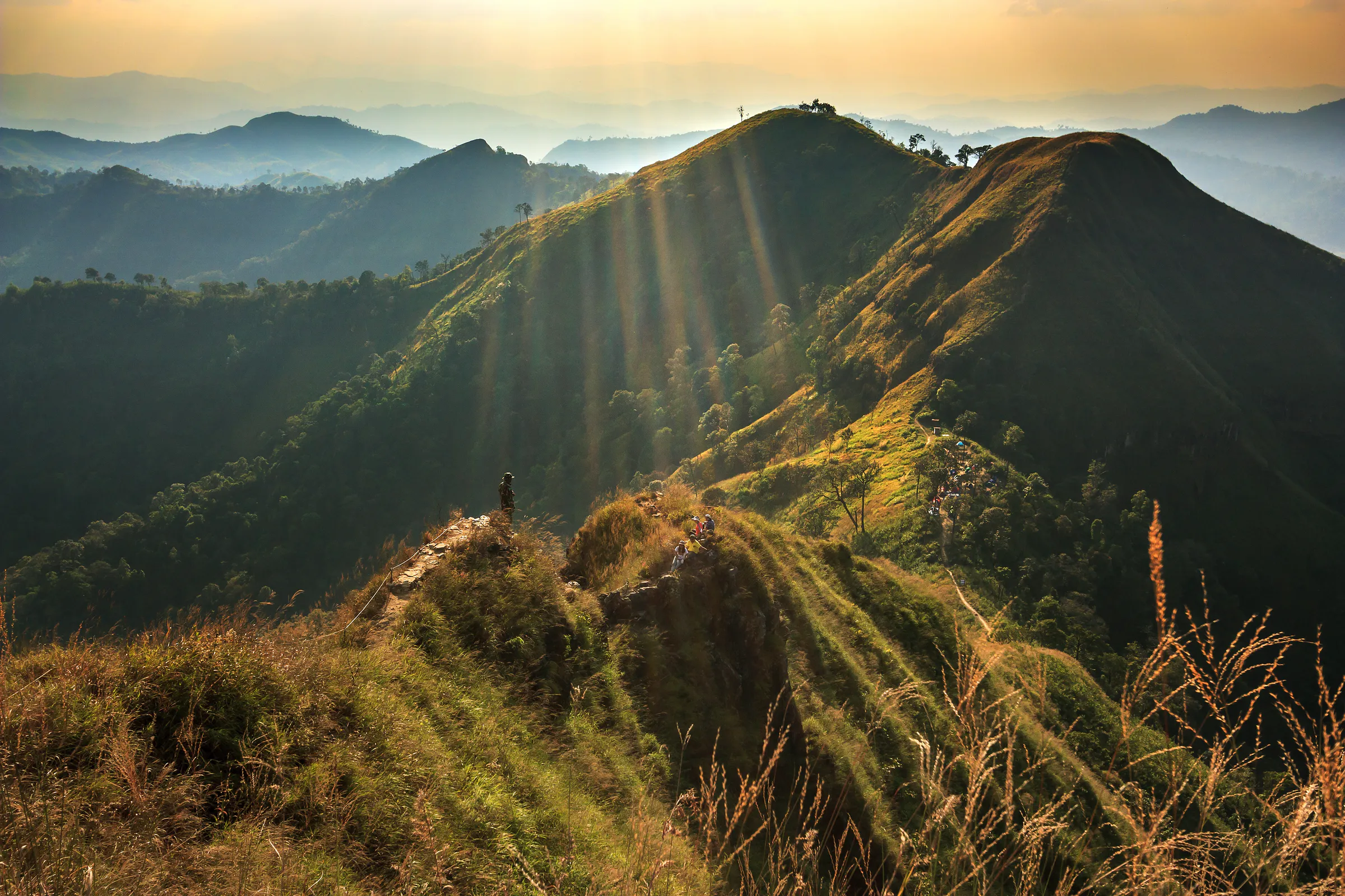
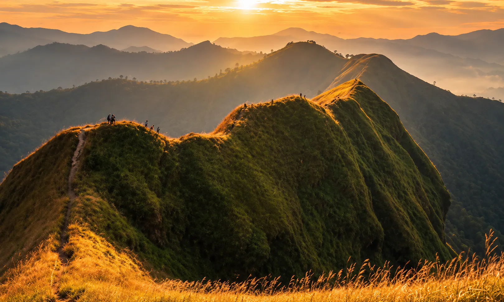
If one landscape has come to represent Thong Pha Phum, it is Khao Chang Phueak. At approximately 1,249 metres, it is the highest mountain in the park. It is not famous simply because of its elevation. It is the ridge walk that makes the journey memorable.
The trail passes through relatively open forest and grassland before reaching exposed ridges with expansive views. The most famous section is San Kom Mead — a narrow ridge that has become one of the signature hiking scenes in Kanchanaburi.
From the upper sections, hikers can see layers of mountains stretching toward the horizon. On clear days, the scale of the Western Forest becomes particularly impressive.
The Khao Chang Phueak Trek
Khao Chang Phueak is a serious hiking experience, not an ordinary sightseeing trail. The commonly published route is approximately 8 kilometres one way, requiring around six hours of walking to reach the camping area, followed by an overnight stay and the summit experience.
The route traditionally operates under a controlled system with:
- Limited visitor numbers
- Advance reservation
- Park staff
- Local porters
- Designated camping
- Specific opening periods
The exact rules and opening dates are determined by the national park. For example, the park reopened the trail from 1 November 2023 to 31 January 2024, with a limit of 60 visitors per day and advance booking. These dates are historical. They are not the current season’s opening dates.
Before hiking
Prepare for long walking distances, steep and uneven terrain, strong sun on open ridges, cold or windy conditions at elevation, limited facilities, overnight camping and rapid weather changes.
Treat Khao Chang Phueak as a mountain expedition, not a casual park walk.
San Kom Mead
สันคมมีด · the knife-edge ridge
San Kom Mead is the section of the Khao Chang Phueak route that has become particularly famous among Thai hikers. The ridge is narrow and exposed in places, with steep slopes dropping away on either side. The reward is an extraordinary sense of openness.
Instead of walking through a closed forest, hikers move along the crest of the mountain with views extending across the surrounding landscape. The ridge is especially dramatic when mist moves through the valleys below.
This is also the section where hikers need to be most careful. Strong wind, rain, fog and slippery ground can change the character of the trail quickly. Follow park staff instructions and never leave the designated route.
360-Degree Mountain Views
One of the defining experiences of Khao Chang Phueak is the panoramic view from the summit. The summit area provides a broad perspective across forest, mountains, valleys, reservoirs and border landscapes.
The experience is less about seeing a single famous landmark and more about understanding the scale of western Thailand’s mountain forests. For photographers, early morning and late afternoon can produce particularly atmospheric conditions, especially when mist fills the valleys.
Chok Kradin Waterfall
น้ำตกจ๊อกกระดิ่น · water falling through the forest
Chok Kradin Waterfall is one of the best-known natural attractions associated with Thong Pha Phum. The waterfall lies in the forested Pilok area, where streams descend through mountainous terrain. Unlike Khao Chang Phueak, Chok Kradin can be experienced without a multi-day mountain trek.
The waterfall becomes especially impressive during periods of higher rainfall, when the surrounding forest is lush and the stream carries more water. A viewpoint around Doi Tong Palae provides another perspective, with Chok Kradin visible from the viewpoint area.
Conditions vary with the season. Check current access and safety information before entering waterfall areas.
Pha Pae Waterfall
Pha Pae Waterfall is another waterfall in the park’s mountainous landscape, associated with the evergreen forest of the Pilok area. Reaching some of the more remote waterfalls requires more preparation than visiting the main park facilities.
Older tourism information specifically notes that some waterfall routes in the area may require a four-wheel-drive vehicle and a local guide because of their remote terrain. For visitors, that remoteness is part of the attraction. The farther you move from the main roads, the more the landscape begins to feel like genuine mountain wilderness.
Chet Mit Waterfall
Chet Mit Waterfall is another waterfall associated with Thong Pha Phum’s remote forest landscape. Together, the Chok Kradin, Pha Pae and Chet Mit routes show the diversity of the park’s waterways.
These are not simply isolated tourist sites. They are part of the mountain watershed created by the Tanaosri range. Water begins high in the forest, travels through valleys and eventually joins larger river and reservoir systems.
Doi Tong Palae
Doi Tong Palae provides one of the park’s scenic viewpoints. Tourism information published for Kanchanaburi places the viewpoint area approximately 300 metres uphill from the area where Chok Kradin Waterfall can be viewed.
The landscape opens toward the surrounding mountains and forest. It is a relatively simple way to experience the mountain scenery without undertaking the full Khao Chang Phueak expedition.
Noen Kut Doi
Noen Kut Doi is another important viewpoint. Unlike the remote mountain trails, it can be reached by vehicle under suitable conditions. From the viewpoint, visitors can see the surrounding mountains, the Vajiralongkorn Dam reservoir and Khao Chang Phueak.
A panoramic landscape without the overnight Khao Chang Phueak trek.
Pilok: The Mountain Gateway
ปิล็อก · mining history, mist and the border
The park is closely associated with Pilok, a mountainous area near the Thailand–Myanmar border. Pilok developed historically around mining. The region once had numerous tin and wolfram (tungsten) mines, and remnants of that history remain part of the area’s identity.
Today, Pilok is better known for mountain scenery, mist, a historic mining atmosphere and access toward Khao Chang Phueak and Thong Pha Phum National Park. The character of the region is mining history, mountain forest and border landscape together. The nearby Ban E-Tong community is an important base for travellers exploring the Pilok area.
Forests of Thong Pha Phum
The park is part of one of Thailand’s most important western forest landscapes. The Department of National Parks identifies four principal forest types.
Moist evergreen forest
Moist evergreen forest contains species such as Hopea, dipterocarps, keruing, kankrao, Malabar ironwood, wild nutmeg, various palms, ferns and rattan. The forest floor can be dense with ferns, palms and climbing plants.
Dry evergreen forest
Dry evergreen forest occurs where moisture conditions differ. Trees recorded in the park include yang, takian, wild mango, yem hom, wild magnolia, krabak, Malayan apple and various other forest species. These forests remain important habitat for wildlife throughout the year.
Hill evergreen forest
At higher elevations the vegetation changes. Hill evergreen forest contains species associated with cooler, wetter mountain environments, including oaks, magnolia relatives, benzoin, cinnamon, various montane plants, mosses and ferns. This vegetation is particularly important around the higher mountains.
Mixed deciduous forest
Mixed deciduous forest is widespread. Trees include Afzelia, rosewood, Lagerstroemia, padauk, Burma ironwood, and various figs and other deciduous species. Bamboo is also common. The changing foliage makes this forest especially interesting during the transition between wet and dry seasons.
Wildlife
Thong Pha Phum is part of the Western Forest Complex, making it important habitat for a wide range of wildlife. Species documented in descriptions of the park include:
- Asian elephant, gaur, sambar deer, muntjac and wild boar
- Bears, gibbons, langurs and macaques
- Civets, leopard cat, fishing cat, clouded leopard and tiger
- Malayan porcupine, flying squirrels and numerous bat species
- Hornbills, eagles, owls, woodpeckers and wild junglefowl
- Many other birds, reptiles and amphibians
The park’s border forests also form part of a larger habitat network extending toward Myanmar. Wildlife sightings are never guaranteed. More importantly, these are wild animals in a functioning forest ecosystem. Do not feed wildlife, approach animals or attempt to attract them for photographs.
The Western Forest Complex
Thong Pha Phum’s ecological significance becomes clearer on a larger map. The park is part of the Western Forest Complex, a large interconnected protected landscape extending across western Thailand. It lies close to Thung Yai Naresuan Wildlife Sanctuary, Khao Laem National Park, Sai Yok National Park and protected forests along the Myanmar border.
This connectivity is critical for species that require large territories. For elephants and other large mammals, a landscape of connected forests is far more valuable than isolated pockets of habitat. Thong Pha Phum is one piece of a much larger conservation landscape.
Climate
Thong Pha Phum has a tropical monsoon climate. The Department of National Parks describes three broad seasons. Because the park contains steep mountain terrain, conditions can vary significantly between the lowlands and the summit.
Hot season · February – April
Temperatures rise, particularly in lower areas. Mountain elevations can remain considerably cooler.
Rainy season · May – July
The southwest monsoon brings increased rainfall. Streams and waterfalls generally become more active, while forest vegetation becomes particularly lush.
Cool season · November – January
The weather is generally cooler and more comfortable for hiking. Higher elevations can feel genuinely cold at night.
Best Time to Visit
There is no single best month for every experience.
- Khao Chang Phueak
- The trail is generally operated during a limited cooler-season window, subject to the park’s annual announcement. Always check the current season’s opening dates before planning.
- Waterfalls
- The rainy season can produce stronger flow and greener forest. Heavy rain may make trails slippery and can affect access.
- Mountain views
- Cooler, drier periods can provide clearer views. Early morning often offers the best atmosphere.
- Mist
- Pilok and the surrounding mountains can experience mist during humid and cooler periods. Exact conditions vary with the weather.
Camping
Camping is an important part of the Thong Pha Phum experience. The Department of National Parks currently lists accommodation and camping services at the park headquarters, including designated camping areas and park houses.
For Khao Chang Phueak, overnight camping is part of the controlled trekking experience, not ordinary walk-in camping. Because accommodation, camping capacity and mountain-trail access can change, use the official DNP reservation system or contact the park directly before travelling.
How to Get There
The usual route from Bangkok is Bangkok → Kanchanaburi → Thong Pha Phum → Highway 3272 → Pilok / National Park.
From Kanchanaburi, travellers follow Highway 323 toward Thong Pha Phum. The road then continues via Highway 3272, the Thong Pha Phum–Pilok route. The national park headquarters is reached along this mountain road. Tourism information places the headquarters approximately 57 km along Highway 3272 from the Thong Pha Phum area, although actual travel time depends heavily on road and weather conditions.
By car
A private vehicle is the most convenient way to explore the park and the surrounding Pilok area. The final mountain roads contain many curves and steep sections. Drive carefully at night, in heavy rain, in fog and on wet mountain roads. Do not underestimate the distance because the map shows a relatively short route. Mountain roads can take substantially longer than the same distance on a flat highway.
By public transport
Travellers without a private car can travel from Bangkok toward Kanchanaburi, then continue to Thong Pha Phum by local bus. From Thong Pha Phum, local transport can connect toward the Ban E-Tong / Pilok area. Services to the mountain area are less frequent than urban routes, so confirm departure times locally and plan accordingly.
What to Bring
- A normal park visit
- Comfortable shoes, drinking water, sun protection, insect repellent, a light rain jacket, a small first-aid kit, a camera and cash.
- Khao Chang Phueak
- Proper hiking shoes, long-sleeved clothing, a warm layer, a headlamp or flashlight, sufficient drinking water, personal medication, sun protection, waterproof protection for electronics and appropriate camping equipment.
The park may have additional requirements for the controlled trek. Follow the equipment list issued for the current season.
Responsible Travel
Thong Pha Phum is a genuine wilderness environment. Visitors can help protect it by following a few simple principles.
- Leave no trace
- Carry your waste out.
- Protect the forest
- Do not collect plants, flowers, rocks or wildlife.
- Respect wildlife
- Never feed animals or approach them.
- Stay on trails
- Especially on steep mountain ridges.
- Protect water sources
- Do not use soap, shampoo or chemicals in streams and waterfalls.
- Respect local communities
- Pilok and surrounding communities have their own history and way of life.
- Follow park closures
- A temporary closure is usually connected to weather, safety, wildlife or conservation.
Beyond Khao Chang Phueak
It is easy to think of Thong Pha Phum as simply the national park with Khao Chang Phueak. That would miss much of the story. Khao Chang Phueak is the most famous experience, but the park is much larger. Its identity also comes from:
- Chok Kradin Waterfall, Pha Pae Waterfall and Chet Mit Waterfall
- Doi Tong Palae and Noen Kut Doi
- Pilok and Ban E-Tong
- Evergreen forests and Western Forest wildlife
- Thailand–Myanmar border landscapes
Together, these form a destination that can easily occupy more than a single day.
A Different Kanchanaburi
Kanchanaburi is often associated with rivers, waterfalls, history and the River Kwai. Travel farther west and upward into the mountains and the province changes completely. The landscape becomes cooler. The roads become narrower. The forest becomes denser. Mist settles between mountains. And the border landscape stretches toward Myanmar.
This is Thong Pha Phum — a place where the geography of western Thailand becomes visible, mountain after mountain, forest after forest.
ThailandLover Travel Guide
- Best for
- Hikers, nature lovers, wildlife watchers, photographers, campers and adventure travellers
- Travel style
- Nature, adventure, wildlife and a mountain escape
- Don’t miss
- Khao Chang Phueak, San Kom Mead, Chok Kradin Waterfall, Doi Tong Palae, Noen Kut Doi and Pilok
- Best experience
- Stay overnight in the mountain area and combine a viewpoint or waterfall with the surrounding forest
- Travel character
- Wild, misty, rugged, remote and scenic
Essential Information
- Park
- Thong Pha Phum National Park · อุทยานแห่งชาติทองผาภูมิ
- Address
- Pilok, Thong Pha Phum District, Kanchanaburi, Thailand
- Province
- Kanchanaburi
- Districts
- Thong Pha Phum and Sangkhla Buri
- Established
- 23 December 2009 · National Park No. 114
- Official DNP area
- 772,214.27 rai / 1,235.54 km²
- Highest point
- Khao Chang Phueak — 1,249 metres
- Mountain range
- Tanaosri Range
- Main attractions
- Khao Chang Phueak, San Kom Mead, Chok Kradin Waterfall, Pha Pae Waterfall, Chet Mit Waterfall, Doi Tong Palae and Noen Kut Doi
- Main ecosystems
- Moist evergreen, dry evergreen, hill evergreen and mixed deciduous forest
- Wildlife
- Asian elephant, gaur, sambar, muntjac, gibbons, langurs, bears, hornbills, forest birds and many other species
- Park contact
- +66 34 510 979
+66 98 252 0359
Khao Chang Phueak is a controlled seasonal trek. Opening dates, visitor limits, reservations, camping and safety conditions can change. Check directly with Thong Pha Phum National Park before travelling.
Frequently Asked Questions
- What is Thong Pha Phum National Park?
- A mountain wilderness in western Kanchanaburi, on the Tanaosri Range toward the Myanmar border. It protects steep forest, waterfalls, highland grassland and watersheds inside the Western Forest Complex, and is best known for Khao Chang Phueak.
- Where is it, and how large is it?
- Thong Pha Phum and Sangkhla Buri districts, Kanchanaburi. Established 23 December 2009 as national park No. 114. Official area: 772,214.27 rai, or 1,235.54 km².
- How hard is the Khao Chang Phueak trek?
- It is a mountain expedition. The commonly published route is about 8 km one way — around six hours to the camping area — then an overnight stay. Numbers are limited, booking is required, and opening dates change. A past window of 1 November 2023 to 31 January 2024, with 60 visitors a day, is historical, not the current season.
- When is the best time to visit?
- Khao Chang Phueak generally opens in a cooler-season window announced by the park. Waterfalls are stronger in the rainy months DNP describes as May to July. Clearer views are more likely in cooler, drier weather. Check the current season before you go.
- Can I visit without the ridge trek?
- Yes. Chok Kradin and Doi Tong Palae do not require the multi-day hike. Noen Kut Doi can often be reached by vehicle, with views toward the Vajiralongkorn reservoir and Khao Chang Phueak. Some remote waterfall routes may need a four-wheel-drive and a local guide.
- How do I get there?
- Bangkok to Kanchanaburi, Highway 323 to Thong Pha Phum, then Highway 3272 toward Pilok. The headquarters is about 57 km along Highway 3272 from the Thong Pha Phum area. A private car is the most practical option.
- How do I contact the park?
- +66 34 510 979 and +66 98 252 0359. Use the official DNP reservation system, or call the park, for camping and the current Khao Chang Phueak dates.
More of Kanchanaburi’s Wild Parks
- Khao Laem National Park
- The reservoir and mountain country immediately east — Vajiralongkorn Dam, San Nok Wua and Sangkhla Buri.
- Sai Yok National Park
- Forest and waterfalls along the Khwae Noi, on Thong Pha Phum’s southern edge.
- Khuean Srinagarindra National Park
- Dam shores, forest ridges and another piece of Kanchanaburi’s western water landscape.
- Erawan National Park
- The province’s famous tiered waterfall, closer to town and easier to combine with a river stay.
- Lam Khlong Ngu National Park
- An emerald forest stream and a quieter waterfall walk in the same western mountains.
- Chaloem Rattanakosin National Park
- Cave chambers and forest trails on the nearer side of Kanchanaburi.
Location
Find Thong Pha Phum National Park
Pilok, Thong Pha Phum District, Kanchanaburi · Highway 3272 from Thong Pha Phum toward the Myanmar border