

National Park · Kanchanaburi
Lam Khlong Ngu National Park
อุทยานแห่งชาติลำคลองงู
The Hidden Limestone World of Western Thailand
Thong Pha Phum · Tenasserim Range
A ThailandLover guide to where Thailand goes underground — limestone mountains, hidden rivers and extraordinary caves, including the 62.5-metre column of Tham Sao Hin.
An Expedition, Not a Viewpoint
Deep in the mountains of Kanchanaburi lies a landscape that feels less like a conventional national park and more like an expedition into another world.
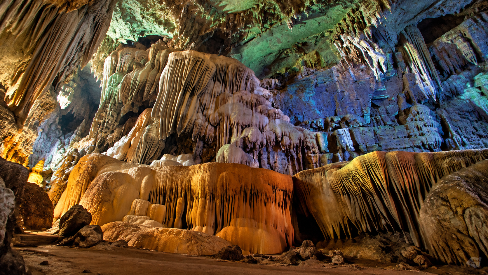
Lam Khlong Ngu National Park is a dramatic landscape of limestone mountains, forested valleys, underground streams, waterfalls and enormous cave systems. Its most extraordinary feature lies beneath the forest: a network of water-carved caves where rivers disappear underground, sunlight disappears completely, and limestone formations have been shaped over immense periods of time.
This is the Thailand of karst mountains, hidden rivers and deep caves — wild, remote and remarkably physical.
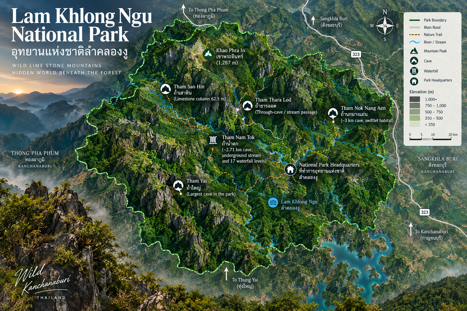
The park is particularly famous for Tham Sao Hin, where a monumental limestone column rises approximately 62.5 metres inside the cave. It also contains Tham Nok Nang Aen, a long stream cave associated with swiftlets and striking calcite formations; Tham Nam Tok, where an underground stream forms a sequence of waterfalls; and Tham Yai, the largest cave in the park.
Lam Khlong Ngu is not primarily a sightseeing destination. It is a destination for people who want to walk, climb, wade, swim, explore and experience the landscape from inside it.
At a Glance
- Official Name
- Lam Khlong Ngu National Park
- Thai Name
- อุทยานแห่งชาติลำคลองงู
- Province
- Kanchanaburi
- District
- Thong Pha Phum · Chalae Subdistrict
- Landscape
- Limestone mountains, valleys, forests, streams and cave systems
- Mountain Range
- Tenasserim / Tanaosri Range
- Area
- 672.60 km² / approximately 420,374 rai
- National Park No.
- 123rd national park
- Established
- 25 December 2009
- Signature Feature
- Tham Sao Hin and its approximately 62.5-metre limestone column
- Other Major Caves
- Tham Nok Nang Aen, Tham Nam Tok, Tham Yai
- Main River System
- Lam Khlong Ngu
- Best Known For
- Cave exploration, limestone landscapes, waterfalls and adventure trekking
- Experience Level
- Moderate to physically demanding, depending on route
The park covers approximately 672.60 square kilometres, or around 420,374 rai, in Thong Pha Phum District. The landscape is dominated by complex limestone mountains belonging to the Tenasserim mountain system.
Why Lam Khlong Ngu Is Different
Many national parks are experienced from the surface. Lam Khlong Ngu is experienced both above and below ground.
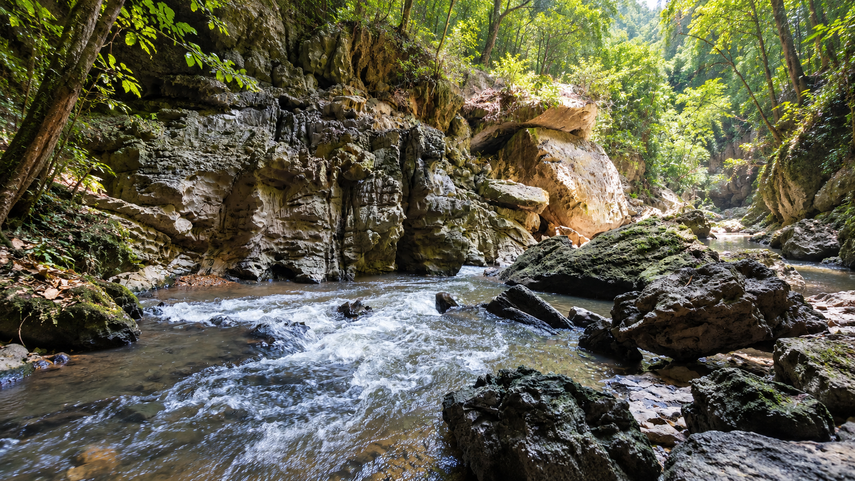
The forest hides an intricate limestone landscape shaped by water. Streams move through valleys, disappear into rock and emerge again elsewhere. Over long periods of geological time, water has enlarged fractures and passages within the limestone, creating caves, underground streams, chambers, stalactites, stalagmites and enormous limestone structures.
The result is a landscape with two very different faces.
- Above ground
- Mountains, forest, cliffs, streams and waterfalls.
- Below ground
- Darkness, underground rivers, enormous chambers, mineral formations and passages carved by water.
This relationship between surface water and underground limestone is the defining character of Lam Khlong Ngu.
The Landscape
Lam Khlong Ngu lies within the mountainous terrain of western Kanchanaburi. The park is characterised by:
- Complex limestone mountains and karst cliffs
- Steep valleys and forested ridges
- Surface streams and underground waterways
- Large cave systems
- Waterfalls and natural rock formations
The terrain is not a flat recreational park. Routes can involve significant elevation changes, uneven limestone surfaces, river crossings and narrow passages. That physical character is an important part of the experience.
Lam Khlong Ngu rewards visitors who are willing to move slowly through the landscape rather than simply drive from one viewpoint to another.
A World Built by Water
The caves of Lam Khlong Ngu are fundamentally water landscapes.
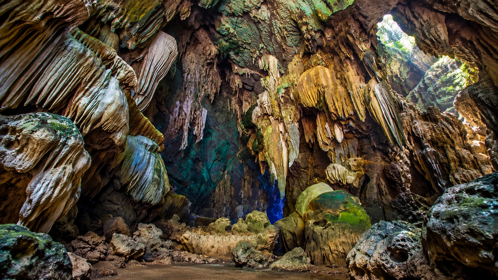
Streams have entered cracks and weaknesses in limestone, gradually enlarging underground passages. At the same time, mineral-rich water has deposited calcium carbonate, creating the formations that give caves their distinctive appearance.
Inside the caves, this process produces:
- Stalactites and stalagmites
- Flowstone, curtains and draperies
- Limestone columns and calcite crystals
- Underground streams and waterfalls
- Large chambers
The most spectacular formations are not decorative additions to the landscape. They are the landscape.
Tham Sao Hin
The cave of the giant limestone column
If Lam Khlong Ngu has one natural icon, it is Tham Sao Hin. The cave contains a monumental limestone column rising approximately 62.5 metres from the cave floor.
A limestone column forms when cave deposits grow until formations originating from the ceiling and floor eventually connect. At Tham Sao Hin, the scale of this formation is extraordinary. The column stands within a large underground chamber, surrounded by the darkness and geological structures of the cave.
It is one of the most remarkable cave formations in Thailand — described by the Department of National Parks as the highest limestone column in the world.
Getting there is part of the experience
Tham Sao Hin is not a conventional cave attraction with a paved walkway leading to an illuminated chamber. The route described by the Department of National Parks involves travelling from the park headquarters toward Protection Unit Lo.Ngo.1 (Khao Phra In), followed by approximately 3 kilometres of trekking down into the valley. The route then involves crossing a waterfall and entering the cave system.
Inside, visitors may need to:
- Walk through water and swim
- Climb over rocks
- Negotiate uneven cave surfaces
- Move through underground passages
The park does not permit overnight camping inside the cave.
Think of Tham Sao Hin as a cave expedition, rather than an ordinary sightseeing stop.
Tham Nok Nang Aen
The swiftlet cave · about 3 km
Further into the park is Tham Nok Nang Aen, a long stream cave extending approximately 3 kilometres. The cave is associated with swiftlets, and its walls contain striking mineral formations including glittering calcite crystals.
Inside are also:
- Stalactites and stalagmites
- Limestone curtains
- Large cave chambers
- Underground water passages
The combination of flowing water, darkness and mineral formations gives Tham Nok Nang Aen a very different character from the more monumental Tham Sao Hin. Rather than focusing on a single giant formation, the experience is about travelling through an extended underground landscape.
The Department of National Parks identifies Tham Nok Nang Aen as a stream cave of approximately 3 kilometres in length and notes the presence of swiftlets and extensive calcite formations.
Tham Nam Tok
An underground waterfall system · about 2,710 m
The name Tham Nam Tok — literally “Waterfall Cave” — reflects one of the park’s most unusual underground landscapes. The cave extends for approximately 2,710 metres and contains an underground stream that descends through a series of waterfalls. The Department of National Parks describes more than 17 waterfall levels within the cave.
The experience is therefore not simply “walking into a cave.” It is following a river into the mountain. Water becomes the route. The cave becomes the landscape. And the boundary between river, rock and underground chamber almost disappears.
Tham Yai
The park’s largest cave
Tham Yai, meaning “Big Cave”, is described by the Department of National Parks as the largest cave in Lam Khlong Ngu National Park. Its entrance is particularly impressive, forming a very large natural opening capable of accommodating large numbers of people.
The scale of the entrance provides a striking contrast with the deeper cave environment, where natural darkness and underground formations take over.
The caves of Lam Khlong Ngu are not small cavities hidden inside rocks. Some are enormous geological spaces.
Tham Thara Lod
Another important cave environment within the park is Tham Thara Lod, associated with the park’s characteristic stream-through-limestone landscape.
The broader Thara Lod cave system reflects the same geological relationship found throughout Lam Khlong Ngu: water moving through limestone and creating passages beneath the forest. For visitors interested in the geology of the park, this is an important part of understanding why Lam Khlong Ngu contains such an exceptional concentration of caves.
Waterfalls Above and Below Ground
Lam Khlong Ngu is not only about caves. Waterfalls are an important part of the park’s surface landscape as well.
- Nangkruan Waterfall
- A natural waterfall destination associated with forest trails and the Thung Nangkruan area. The surrounding route is known for forest vegetation, wildflowers and fungi — interesting for waterfall lovers and for anyone curious about forest ecology.
- Klity Waterfall
- Another example of the limestone-water landscapes characteristic of western Kanchanaburi. Access to individual waterfalls can be seasonal and may change according to rainfall, wildlife activity and park management decisions.
Forest & Biodiversity
The caves may be the reason many travellers first discover Lam Khlong Ngu, but the caves exist because of the forest and mountain landscape around them.
The park contains forest ecosystems associated with the western Thai mountains, including mixed deciduous and dry evergreen forest environments. Vegetation varies according to elevation, moisture and terrain. In lower and drier areas, mixed deciduous forest and bamboo are important components. Along streams and in more humid valleys, vegetation becomes denser and more evergreen.
Forest, limestone and water are closely interconnected. That is the park’s ecological identity.
Wildlife
Lam Khlong Ngu forms part of the larger western forest landscape of Thailand, one of the country’s most important areas for wildlife conservation. Wildlife recorded or associated with the broader landscape includes:
- Asian elephant and gaur
- Sambar deer, barking deer and wild boar
- Serow
- Various primates, civets and porcupines
- Numerous bird species, reptiles and amphibians
The presence of wildlife is not simply an attraction. It is a reminder that Lam Khlong Ngu remains a functioning forest ecosystem rather than a recreational landscape built solely for tourism.
Treat animal encounters as wildlife encounters — not photo opportunities.
A Particularly Important Wildlife Consideration
Elephants are present in the broader landscape, and wildlife movement can affect visitor access. This is not theoretical.
In March 2026, the park temporarily closed Nangkruan Waterfall because a herd of approximately 15–20 wild elephants had repeatedly been using the area and officials considered the situation unsafe for visitors. The closure was ordered from 1 March 2026 until conditions returned to normal.
Park access is dynamic. A trail that is open in one season may be restricted later.
Closures and changes can follow:
- Heavy rainfall and flash-flood risk
- Cave water levels and trail conditions
- Wildlife activity
- Conservation measures
- Operational decisions by park authorities
Always verify current conditions before travelling.
The Adventure Factor
Lam Khlong Ngu is one of the national parks where the word adventure is genuinely appropriate. Depending on the route, visitors may encounter:
- Trekking
- Trails can pass through forest, steep valleys and uneven limestone terrain.
- River crossing and wading
- Water is an integral part of several cave experiences. Some routes require walking through shallow sections of streams.
- Swimming
- Certain cave routes involve swimming through underground water.
- Climbing
- Rock scrambling and climbing over natural limestone surfaces may be necessary.
- Cave exploration
- The major cave routes are natural environments rather than conventional tourist caves.
This is fundamentally different from a national park where visitors remain on paved paths.
Who Should Visit?
Lam Khlong Ngu is particularly suitable for travellers who enjoy:
- Adventure travel, caving and trekking
- Wildlife, geology and natural landscapes
- Photography and small-group exploration
- Off-the-beaten-path, physical outdoor experiences
It is less suitable for travellers looking for:
- Easy sightseeing or short walks
- Wheelchair-accessible attractions
- Fully developed tourist infrastructure
- Comfortable cave tours, or attractions reached entirely by car
Lam Khlong Ngu is not difficult because it is inaccessible for the sake of being inaccessible. Its difficulty comes from the landscape itself.
When to Go
For cave exploration, water conditions are one of the most important considerations. The Department of National Parks specifically advises travelling outside the rainy season for the Tham Sao Hin route because visitors must negotiate water inside the cave. A tourism information source associated with the Thai sustainable-tourism network identifies approximately February–April as a suitable period for Tham Sao Hin because water levels are generally lower, while cautioning against the rainy season.
- February – April
- Best suited to cave adventure. Generally lower water levels can make cave routes more manageable, subject to the park’s current operating conditions.
- May – October
- Rainy-season caution. Heavy rainfall can affect streams, waterfalls, cave water levels and trail safety. For underground routes, rainfall upstream can matter even when conditions at the cave entrance appear acceptable.
- November – January
- Cooler forest conditions. Generally more comfortable for outdoor activities, although individual attractions may have their own opening periods.
A Note About Seasonal Openings
Lam Khlong Ngu does not operate as though every attraction is permanently available throughout the year. Different areas can have different seasonal opening periods.
For example, a Department of National Parks announcement for the 2024–25 tourism season listed:
- Lower Klity Waterfall: 1 November – 30 April
- Nangkruan Waterfall and camping area: 1 November – 30 June
These dates should be treated as historical seasonal guidance rather than a permanent annual timetable.
How to Get There
Lam Khlong Ngu National Park is located in Thong Pha Phum District, Kanchanaburi Province. From Kanchanaburi, the main approach uses Highway 323 toward Thong Pha Phum.
According to the Department of National Parks, the route to the park headquarters follows Highway 323 to Phuttho Junction, then turns right for approximately 12 kilometres, followed by another right turn for approximately 4 kilometres to the park headquarters.
Kanchanaburi → Highway 323 → Thong Pha Phum → Phuttho Junction → Lam Khlong Ngu National Park
For cave expeditions, reaching the park headquarters is only the beginning. The Tham Sao Hin route continues toward Protection Unit Lo.Ngo.1 (Khao Phra In) before the trekking section begins.
Getting Around the Park
Do not think of Lam Khlong Ngu as a single attraction. It is a large protected landscape with different access points, trails and activity areas. Some destinations require:
- Vehicle transfers and park-staff coordination
- Trekking and water crossings
- Specialist equipment
- Appropriate physical preparation
For cave routes, follow the instructions of park staff and local guides rather than attempting to navigate independently.
Safety First
This is one of the most important sections for anyone planning Lam Khlong Ngu.
1. Do not enter caves independently
The major cave routes are complex natural environments. Follow the park’s current access rules and use the required staff or guides. The Department of National Parks specifically describes the Tham Sao Hin route as involving water crossings, swimming and climbing.
2. Water level matters
A cave containing a stream can change dramatically after rainfall. Water conditions can affect passage depth, current strength, swimming sections, rock surfaces, exit routes and overall cave safety. A route that looks manageable under low-water conditions can become dangerous after heavy rain.
3. Know your physical limits
Cave routes may involve several hours of continuous physical activity. You may need to walk long distances, climb, crawl or scramble, keep your balance on wet limestone, swim, carry equipment and move through darkness. This is not the place to discover halfway through the route that you dislike swimming.
4. Wear appropriate equipment
For adventure cave routes, prepare for wet conditions, slippery limestone, darkness, temperature changes and extended physical activity. Equipment requirements may differ by route and season. Always follow the park’s current instructions.
5. Wildlife is wild
Do not approach elephants, monkeys or other wildlife. Do not feed animals. Do not leave food scraps. Do not attempt to photograph wildlife from unnecessarily close distances. In a landscape where elephants can move through tourist areas, park closures should be understood as genuine safety measures rather than inconveniences.
Responsible Travel
Lam Khlong Ngu contains geological formations that took enormous amounts of time to form. A cave formation can be destroyed in seconds by careless behaviour.
- Never touch cave formations. Oil and dirt from human hands can damage delicate mineral surfaces.
- Never break or remove rocks. Everything inside the cave belongs to the geological landscape.
- Never leave rubbish. What enters a cave can remain there for years.
- Never shout unnecessarily. Sound travels differently underground and can disturb cave wildlife.
- Never disturb swiftlets or other cave animals. The cave is their habitat.
- Follow designated routes. Cave environments are fragile and difficult to restore once damaged.
Photography at Lam Khlong Ngu
The park offers a very different photographic experience from conventional Thai landscapes.
Above ground
- Limestone ridges and mist in mountain valleys
- Forest textures, streams and waterfalls
- Rock formations and seasonal vegetation
Inside the caves
The photographic challenge changes completely. The strongest images often come from scale, silhouette, human figures against enormous chambers, reflections, water movement, mineral textures and light entering cave entrances.
The key is not to over-light the environment. Darkness is part of the landscape.
The Geological Story
The most interesting way to understand Lam Khlong Ngu is not through a historical timeline. It is through geological time.
Limestone landscapes respond to water. Rainwater interacts with the rock and gradually enlarges fractures and cavities. Streams exploit weaknesses in the mountain, carving passages beneath the surface. Over long periods, these passages become caves. Then another process begins. Mineral-rich water deposits calcium carbonate inside the cave, slowly producing stalactites, stalagmites, flowstone and columns.
Mountain + forest + river + cave + underground river. That is the geological identity of Lam Khlong Ngu.
Lam Khlong Ngu and the Western Forest
Lam Khlong Ngu should also be understood as part of the larger protected forest landscape of western Thailand. The surrounding region contains a network of protected areas that together form an important conservation landscape.
For travellers, this means that a visit here is not simply about seeing one cave. It is an opportunity to enter a much larger ecosystem where mountains, forests, rivers and wildlife remain connected. That ecological continuity is one of the most important reasons to experience the area responsibly.
What Makes the Journey Worth It?
There are easier national parks. There are more accessible waterfalls. There are caves with walkways, lights and handrails. Lam Khlong Ngu offers something different. It offers immersion.
- You do not simply look at the cave. You enter it.
- You do not simply photograph the river. You follow it underground.
- You do not simply stand beside limestone mountains. You move through them.
And somewhere inside the darkness of Tham Sao Hin, a 62.5-metre limestone column reveals just how extraordinary the relationship between water and rock can become.
Essential Information
- Destination
- Lam Khlong Ngu National Park · อุทยานแห่งชาติลำคลองงู
- Province
- Kanchanaburi · Thong Pha Phum District
- Area
- 672.60 km² / approximately 420,374 rai
- Landscape
- Tenasserim range, limestone mountains, forest valleys, streams and caves
- Signature
- Tham Sao Hin · approximately 62.5-metre limestone column
- Major Caves
- Tham Sao Hin · Tham Nok Nang Aen · Tham Nam Tok · Tham Yai
- Activities
- Trekking, cave exploration, river crossing, swimming, photography, nature study and wildlife observation
- Difficulty
- Moderate to demanding, depending on route
- Best Cave Period
- Generally the drier months, subject to official opening and water conditions
- Important
- Cave access is seasonal and conditions can change rapidly. Check with the park before travelling.
Before You Go
For a normal scenic visit, Lam Khlong Ngu can be approached as a national-park destination. For the major cave expeditions, prepare as if you are going on an outdoor expedition.
Bring
- Trekking clothing and shoes for wet, uneven terrain
- Drinking water and food appropriate for the route
- Personal medication and basic first-aid supplies
- Waterproof protection for valuables
- Headlamp or equipment specified by the park
- Dry clothing for water-based routes
Follow the park’s current instructions. Do not rely on an old travel blog for opening dates, registration procedures or cave access.
A Note for International Travellers
Lam Khlong Ngu is not a conventional “Thailand tourist attraction.” It is better understood as an adventure destination within a protected natural landscape. Plan more carefully than you would for a city attraction or a developed national-park viewpoint.
Before travelling:
- Confirm whether the specific cave route is open
- Confirm registration requirements
- Confirm whether a guide or park staff must accompany the group
- Check weather, rainfall and current transport
- Confirm equipment requirements
- Allow sufficient time for the entire route
Do not arrive expecting to walk into Tham Sao Hin independently. The journey into the cave is part of the attraction — and part of the safety challenge.
ThailandLover Destination Verdict
- Nature
- Limestone mountains, forest valleys and a living western-forest landscape.
- Adventure
- Trekking, water and caves — the word fits.
- Caving
- Tham Sao Hin, Tham Nok Nang Aen, Tham Nam Tok and Tham Yai.
- Photography
- Scale, darkness, water and mineral texture.
- Wildlife
- A functioning forest, including elephants. Sightings are never guaranteed.
- Accessibility
- Not a drive-up, paved-path park.
- Families with young children
- Major cave routes are physically demanding.
- Experienced outdoor travellers
- One of the journeys this kind of traveller comes for.
- Off the beaten path
- Remote, physical and unlike a standard national-park circuit.
Best for adventure travellers, cave explorers, trekkers, photographers, geology enthusiasts, nature lovers and experienced outdoor travellers.
Not ideal for travellers seeking easy sightseeing, visitors with limited mobility, or anyone uncomfortable with water or physical activity.
Frequently Asked Questions
- What is Lam Khlong Ngu National Park?
- Thailand’s 123rd national park, established on 25 December 2009 in Thong Pha Phum, Kanchanaburi. It covers about 672.60 km² / 420,374 rai of limestone mountains, forest and caves in the Tenasserim range — an adventure landscape, not a conventional sightseeing park.
- What is Tham Sao Hin famous for?
- A limestone column rising approximately 62.5 metres, described by the Department of National Parks as the highest in the world. Reaching it means trekking, water crossings, swimming and climbing. Overnight camping inside the cave is not permitted.
- When should I go for the caves?
- Outside the rainy season. February to April is often the more manageable window because water levels are generally lower. Treat that as guidance, not a guarantee — confirm with the park.
- Can I enter the caves on my own?
- No. Follow current access rules and use the required staff or guides. Do not arrive expecting to walk into Tham Sao Hin independently.
- How do I get there?
- From Kanchanaburi, take Highway 323 toward Thong Pha Phum to Phuttho Junction, turn right for about 12 kilometres, then right again for about 4 kilometres to headquarters. Cave routes continue beyond that point.
- Is everything open all year?
- No. Water, weather, wildlife and park decisions can close individual areas. In March 2026, Nangkruan Waterfall was closed because a herd of about 15–20 wild elephants was using the area. Check before you travel.
More of Kanchanaburi’s Western Forest
- Thong Pha Phum National Park
- The neighbouring western forest, on the same mountain country around Thong Pha Phum.
- Khao Laem National Park
- Lake, ridges and connected forest beside Lam Khlong Ngu’s cave country.
- Khuean Srinagarindra National Park
- Limestone terraces, Huai Mae Khamin and the Srinagarind Reservoir — another face of Kanchanaburi karst.
- Sai Yok National Park
- River, forest and waterfalls farther down the western corridor.
- Erawan National Park
- Kanchanaburi’s famous seven-tier waterfall — a useful contrast with Lam Khlong Ngu’s more demanding caves.
- Nature & Parks
- More protected landscapes across ThailandLover’s collection.
Location
Find Lam Khlong Ngu National Park
Chalae, Thong Pha Phum, Kanchanaburi · Highway 323 via Phuttho Junction