

National Park · Kanchanaburi
Khuean Srinagarindra National Park
อุทยานแห่งชาติเขื่อนศรีนครินทร์
Where Mountains Embrace the Water
Kanchanaburi · Western Thailand
A vast western Thai landscape of limestone mountains, emerald waterfalls, hidden caves, deep forests and the immense Srinagarind Reservoir.
Where the Mountains Meet the Water
There are national parks defined by a mountain. Some are defined by a forest. Others by a waterfall. Khuean Srinagarindra is defined by the relationship between all of them.
Here, mountains descend toward a vast reservoir. Streams emerge from forested ridges. Limestone channels turn ordinary streams into spectacular waterfalls. Caves disappear beneath the mountains. Islands and peninsulas rise from the water where valleys once existed.
This is not simply a park surrounding a dam. It is a landscape in which mountain → forest → stream → waterfall → reservoir has become one interconnected visual and ecological system.
Follow the water. Enter the forest. Discover the West.
At a Glance
- Official Name
- Khuean Srinagarindra National Park
- Thai Name
- อุทยานแห่งชาติเขื่อนศรีนครินทร์
- Province
- Kanchanaburi, Western Thailand
- Districts
- Si Sawat, Sai Yok, Thong Pha Phum
- Established
- 23 December 1981
- National Park Number
- 39th national park of Thailand
- Area
- Approximately 957,500 rai / 1,532 km²
- Landscape
- Mountain ranges, limestone terrain, tropical forest, mixed deciduous forest, streams, waterfalls, caves and reservoir
- Central Water Body
- Srinagarind Reservoir — approximately 419 km²
- Major River
- Khwae Yai River
- Major Waterfall
- Huai Mae Khamin — 7 limestone tiers
- Other Waterfalls
- Pha Tat, Pha Sawan, Kliti
- Major Cave Landscapes
- Nam Lod and other limestone cave systems
- Major Viewpoint
- Noen Sawan Viewpoint
- Protected-Area Context
- Western Forest Complex
- Nearest Major City
- Kanchanaburi — approximately 105 km to the park area
- Signature Experience
- Reservoir + mountain forest + limestone waterfalls
The Department of National Parks identifies Khuean Srinagarindra as Thailand’s 39th national park, established on 23 December 1981. The park covers approximately 1,532 km² across Si Sawat, Sai Yok and Thong Pha Phum. Some secondary provincial tourism pages give a different sequence number; ThailandLover uses the DNP’s official classification.
Thailand’s Western Forest
Khuean Srinagarindra lies in Kanchanaburi, within one of Thailand’s most important remaining forest regions. It is not an isolated green island. It forms part of a much larger protected landscape, among:
- Erawan National Park
- Sai Yok National Park
- Thong Pha Phum National Park
- Khao Laem National Park
- Lam Khlong Ngu National Park
- Thung Yai Naresuan Wildlife Sanctuary
- Salak Phra Wildlife Sanctuary
For wildlife, the most important feature is not the park boundary. It is connectivity. Animals need to move. Forests need to connect. Rivers need to flow. Genetic populations need to exchange. A large protected-area network is far more valuable than isolated forest fragments.
The Scale Is Easy to Underestimate
The park covers approximately 957,500 rai, or 1,532 km². That is an enormous landscape. For perspective, the reservoir itself covers approximately 419 km² — meaning a substantial portion of what visitors see is water surrounded by forested mountains.
This explains why the park can feel almost endless. One road does not reveal it. One waterfall does not represent it. One viewpoint does not explain it. Khuean Srinagarindra has to be understood as a large-scale mountain–water system.
A lake inside the mountains.
Three Districts, One Protected Landscape
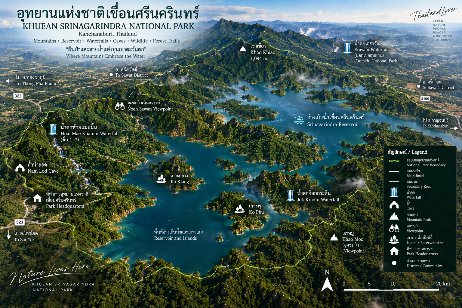
The park extends across three districts of Kanchanaburi. The Department of National Parks confirms all three within the park’s administrative area.
- Si Sawat
- The central landscape. It contains Srinagarind Reservoir, park headquarters and the famous Huai Mae Khamin waterfall area.
- Sai Yok
- The southern and southeastern portions connect the park with the wider forest landscape around Sai Yok.
- Thong Pha Phum
- The northern portion extends toward the mountainous landscape of western Kanchanaburi and connects conceptually with the forests around Thong Pha Phum and Khao Laem.
Srinagarind Reservoir — The Heart of the Landscape
The defining feature of the park is Srinagarind Reservoir, created by the construction of Srinagarind Dam across the Khwae Yai River. The dam became fully operational in 1980. The official opening ceremony took place on 15 June 1981.
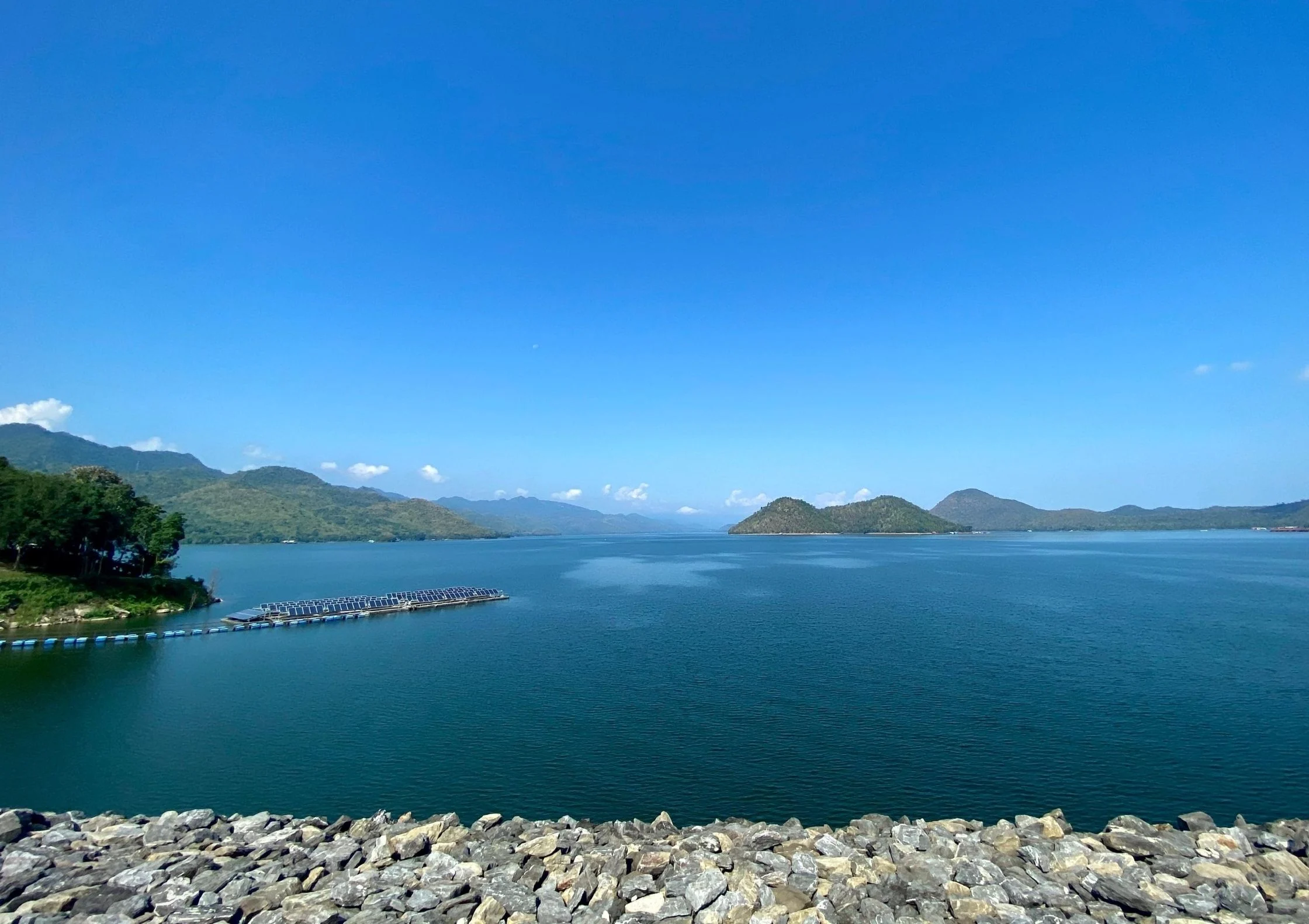
Today the reservoir extends deep into the surrounding mountain landscape. From above it resembles an enormous blue-green network of drowned valleys, peninsulas, forested ridges, islands, narrow channels and mountain coves.
The reservoir does not sit beside the mountains. It enters them.
This is why aerial views of Khuean Srinagarindra are so distinctive — and why islands and peninsulas are among the most photogenic features of the water. Forest-covered ridges rise from the surface. Small islands appear between channels. Mountain slopes descend directly into the reservoir. From above, the landscape looks almost like an inland archipelago.
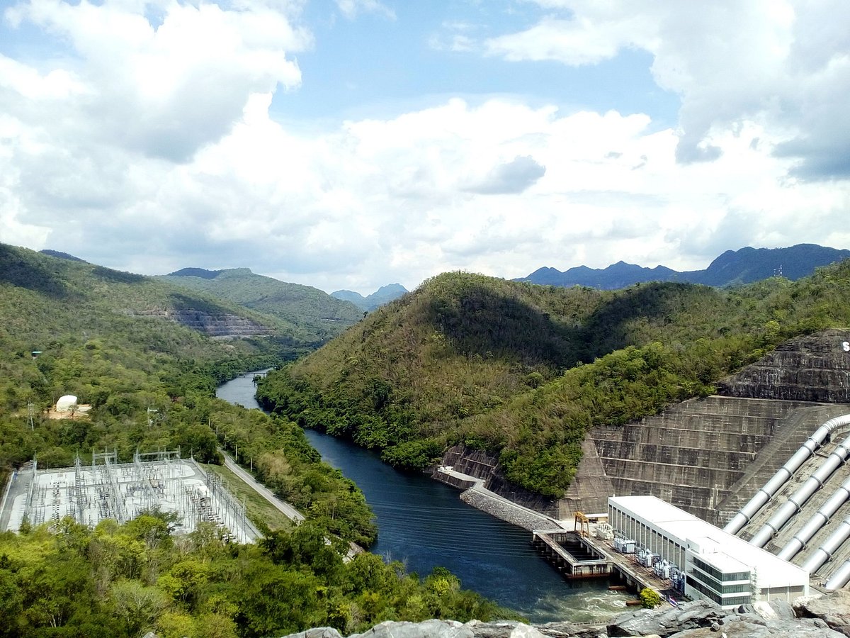
Srinagarind Dam
The dam itself is an engineering landmark. The Electricity Generating Authority of Thailand identifies Srinagarind as the rockfill dam with clay core capable of storing the largest volume of water in Thailand.
- Dam Type
- Rockfill dam with clay core
- Height
- 140 metres
- Crest Length
- 610 metres
- Crest Width
- 15 metres
- Reservoir Area
- 419 km²
- Reservoir Capacity
- 17,745 million cubic metres
- Power Generation
- 720 MW
Srinagarind Hydropower Plant has five generating units: Units 1–3 at 120 MW each, and Units 4–5 at 180 MW each. Units 4 and 5 are pumped-storage units, allowing water to be pumped back into the reservoir as part of electricity-system management.
The dam was designed as a multipurpose project: electricity generation, water storage, irrigation support, water management, flood-management functions, regional economic development, and tourism. It forms part of the Mae Klong River Basin. Its stored water contributes to the larger water-management system of western and central Thailand.
A Landscape Transformed
Before the reservoir existed, the Khwae Yai River flowed through a valley system. Construction of the dam inundated low-lying areas. River channels became reservoir arms. Ridges that once connected continuously became peninsulas. Higher peaks remained above the water and became islands.
This is why the reservoir has such a distinctive shape. It is essentially a mountain landscape partially occupied by water.
The reservoir is not equivalent to a natural lake. It is a human-created water body that has developed its own ecological system — fish, aquatic plants, waterbirds and shoreline habitats — while also changing the original river-valley ecology.
The Name, the Dam and the Park
The Srinagarind Dam project began with studies and surveys in the 1960s. Construction began in 1973. The dam was completed in 1980. The name was formally granted in 1977, honouring Her Royal Highness Princess Srinagarindra, the Princess Mother. The official opening ceremony on 15 June 1981 was attended by King Bhumibol Adulyadej and Princess Maha Chakri Sirindhorn.
Only months later, on 23 December 1981, the surrounding forest landscape was formally declared a national park — Thailand’s 39th. The park later adopted the same name as the dam.
The result is a fascinating visual contrast: a 140-metre dam, a 720-MW hydropower system and a 17,745-million-m³ reservoir, set inside 1,532 km² of mountains, forests, waterfalls, caves and wildlife. Nature and engineering occupy the same landscape. That tension is part of the identity of Khuean Srinagarindra.
Mountains, Limestone and Forest
The park is dominated by complex mountain terrain: steep ridges, limestone mountains, forested valleys, narrow gorges, high plateaus, stream valleys and exposed cliffs. Older park descriptions place the general terrain at approximately 400 metres above sea level, with the highest mountains reaching roughly 1,100–1,200 metres, depending on the source. For ThailandLover, the safest description is a high-relief mountain landscape rising from approximately 400 metres to more than 1,000 metres in the upper ranges.
Limestone has shaped much of the park’s visual identity. Where water encounters limestone, erosion creates channels; channels become gorges; gorges become waterfalls; water dissolves rock underground; caves develop. That geological relationship explains why the park contains so many combinations of water, cliff, cave and waterfall. The Department of National Parks specifically describes Huai Mae Khamin as a limestone waterfall and highlights the park’s limestone cave landscapes.
The forest is not one continuous jungle. It is a mosaic:
- Tropical / moist forest
- Dense forest around streams and areas receiving greater moisture.
- Mixed deciduous forest
- An important forest type across western Thailand. Trees lose some or much of their foliage during the dry season, so the landscape changes markedly between wet and dry months.
- Dry forest
- Drier mountain slopes support vegetation adapted to seasonal drought and fire.
- Limestone forest
- Rocky limestone slopes create distinctive microhabitats.
Every waterfall begins with a simple event: rain falls on the mountain. The forest captures part of that water. Water moves through soil. Streams gather and descend. Rock channels accelerate the flow. Then the water becomes a waterfall — and eventually the reservoir. Without the mountain forest, there would be no functioning watershed.
The real infrastructure of Khuean Srinagarindra is not the dam. It is the forest watershed behind it.
Huai Mae Khamin — The Jewel of the Park
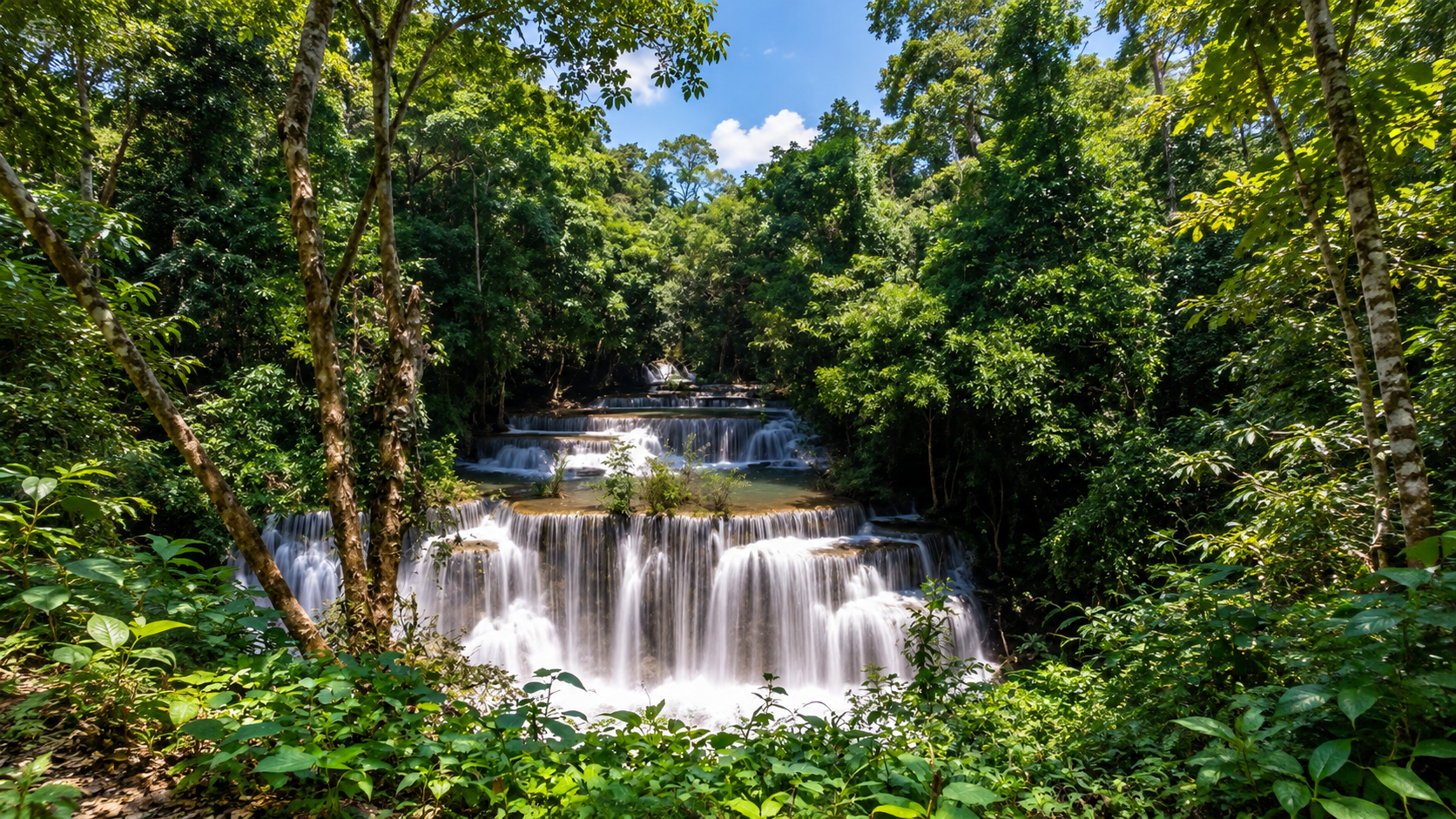
If one attraction represents Khuean Srinagarindra, it is Huai Mae Khamin Waterfall. Located in the central part of the park, its water originates from the Kala mountain range and flows through forest before descending over limestone formations toward Srinagarind Reservoir.
It is a seven-tier waterfall, and each level has its own name. The Department of National Parks describes the route connecting the levels as approximately 2.45 km. This is one of the best ways to experience the park, because the waterfall is not one viewpoint. It is a sequence: you walk, you hear water, the forest changes, another cascade appears.
- 1. Dong Wan · ดงว่าน
- The lower section where the stream begins its dramatic descent.
- 2. Man Khamin · ม่านขมิ้น
- Literally evoking a curtain of turmeric. Falling water spreads over the rock face like a natural veil.
- 3. Wang Na Pha · วังหน้าผา
- A pool and rock section associated with the cliff.
- 4. Chat Kaew · ฉัตรแก้ว
- The signature tier — generally considered the most beautiful section. Water spreads across pale limestone and vegetation frames the cascade. The DNP specifically identifies Chat Kaew as the most beautiful of the seven levels.
- 5. Lai Chon Long · ไหลจนหลง
- A more intimate section where water winds through the landscape.
- 6. Dong Phisuea · ดงผีเสื้อ
- The butterfly forest. The name reflects the area’s association with butterfly-rich habitat around the waterfall.
- 7. Rom Klao · ร่มเกล้า
- The upper section, surrounded by forest.
Huai Mae Khamin looks different from many large Thai waterfalls. Instead of a single enormous vertical drop, the water often spreads across broad limestone terraces: soft white water against golden limestone, inside deep green forest. During suitable flow, the pools can appear turquoise or emerald. That visual identity has made it one of Kanchanaburi’s signature waterfalls.
The complete ecological story is simple and beautiful: Kala Mountains → Huai Mae Khamin → seven limestone tiers → forest stream → Srinagarind Reservoir.
Pha Tat, Pha Sawan and Kliti
Do not treat every waterfall in Khuean Srinagarindra as an easy tourist stop. Some are genuine wilderness destinations. Access can vary with rainfall, road and trail conditions, seasonal closures and park management decisions.
- Pha Tat Waterfall
- The limestone cascade of Thong Pha Phum. Water originates from Huai Kui Mang and descends across limestone cliffs more than 30 metres, in three major tiers. The DNP describes rock terraces, pools and large forest trees. Huai Mae Khamin is long, terraced and emerald; Pha Tat is cliff, forest and pool.
- Pha Sawan Waterfall
- A high forest cascade in a more remote mountain environment, considerably less accessible than Huai Mae Khamin.
- Kliti Waterfall
- A significant waterfall in the park’s mountain landscape. The surrounding Kliti area is also historically and culturally significant, long associated with Karen communities of western Thailand — ecological heritage and human heritage in the same forest.
Hot Springs, Caves and Nam Lod
Khuean Srinagarindra is not only a waterfall destination. The DNP identifies hot springs as one of the park’s characteristic natural features — geothermal water alongside cold mountain streams.
The limestone mountains also create extensive underground landscapes. Caves within the broader park include Nam Lod cave systems, Tham Phrathat, Tham Neramit and other limestone passages. They may contain underground streams, stalactites, stalagmites, chambers, archaeological traces and bat habitats. The DNP specifically highlights water caves and underground passages as characteristic of the park.
- Nam Lod Cave
- The name evokes water flowing through or under the rock. Water has carved passages through limestone, so the boundary between river and mountain disappears. For visitors, this is one of the clearest examples of the geological processes shaping western Kanchanaburi.
Entering a limestone cave means entering a completely different ecosystem: darkness, humidity, water, bats and slow geological processes. A stalactite may take an extremely long time to form. Every cave should be treated as a fragile geological archive.
Never enter a water cave during unstable weather. Follow official park instructions and use authorised guides where required.
Wildlife of the Western Forest
Khuean Srinagarindra forms part of one of Thailand’s largest remaining western forest landscapes. Species presence varies by habitat and location. Seeing wildlife is never guaranteed.
- Large mammals
- Asian elephant, gaur, sambar deer, barking deer, wild boar, serow.
- Carnivores
- Leopard, leopard cat, civets and other small carnivores.
- Primates
- Macaques, langurs, gibbons.
- Small mammals
- Squirrels, porcupines, mouse deer, bats.
The western forests of Kanchanaburi are important elephant habitat. Elephants require enormous territories — water, forest, grass, mineral sources and movement corridors. The scale of protected forest around Khuean Srinagarindra helps provide these conditions. The park should be understood as part of a landscape-scale conservation system, not merely a collection of tourist attractions.
Gaur (Bos gaurus) is one of the largest wild cattle species in Asia, preferring forest with grass, water, open woodland and forest edges. Mainland serow is a mountain ungulate associated with rocky, forested terrain — elusive, and rarely encountered by ordinary visitors. Never attempt to approach, feed or photograph large wild animals at close range.
The DNP highlights the red-eared subspecies of red junglefowl, Gallus gallus spadiceus, among the park’s birdlife. Other forest birds may include hornbills, barbets, bulbuls, drongos, kingfishers, woodpeckers, pheasants and forest flycatchers. Forest edges and stream corridors are especially interesting for birdwatchers.
The name Dong Phisuea — Butterfly Forest — at Huai Mae Khamin reflects butterflies associated with the waterfall environment. Spray creates humidity, flowering plants, wet soil and mineral-rich surfaces. A waterfall should not be judged only by its water. The surrounding micro-ecosystem matters just as much.
Noen Sawan and the Morning Reservoir
Noen Sawan Viewpoint is one of the most attractive viewpoints in the park. The view opens toward forested mountain ridges, Srinagarind Reservoir, distant valleys and surrounding communities. Water occupies the valleys while the mountains remain densely forested.
The reservoir is inside the mountains.
Early morning is when the reservoir becomes most atmospheric. Cool air moves over the water. Mist can gather in valleys. Mountain silhouettes appear behind layers of haze. The water becomes reflective. The forest remains almost silent. This is the moment when Khuean Srinagarindra feels less like a dam project and more like a vast natural lake surrounded by wilderness.
Two Ways to Reach Huai Mae Khamin
- By road
- From Kanchanaburi, travel toward Srinagarind Dam on Highway 3199, then continue toward the park. The DNP describes approximately 105 km from Kanchanaburi city, and about 45 km from the dam-side route to headquarters / Huai Mae Khamin, depending on the starting point.
- By long-tail boat
- Charter a boat from Srinagarind Dam market or Tha Kradan market. The journey takes approximately one hour, depending on route and weather. The DNP identifies this as one of the routes to the Huai Mae Khamin area.
Boat travel changes the perspective completely. From the road: mountain → road → forest. From the water: water → island → cliff → forest → mountain. This is arguably the most characteristic way to experience the reservoir landscape.
The boat does more than transport you. Houses become fewer. Mountains become larger. Water becomes wider. Forest becomes denser — until the landscape feels almost entirely wild.
Khuean Srinagarindra vs. Erawan
These two parks are often confused because they are relatively close. They are not the same. Kanchanaburi’s provincial tourism information lists Erawan separately. Erawan Waterfall is outside Khuean Srinagarindra National Park.
- Erawan National Park
- Famous for Erawan Waterfall, limestone mountains and caves — a more concentrated set of visitor attractions. The waterfall park.
- Khuean Srinagarindra National Park
- Famous for Srinagarind Reservoir, Huai Mae Khamin, Pha Tat, Pha Sawan, Kliti, caves, hot springs and a large-scale mountain landscape. The mountain–reservoir park. Its identity comes from scale.
When to Go
- Rainy season
- Streams become stronger, waterfalls increase in volume, forest turns intensely green, reservoir levels respond to rainfall, and clouds gather around the ridges. Spectacular — and also more slippery trails, flash-flood risk, cave hazards, difficult roads and possible waterfall access restrictions. Follow current park instructions.
- Cool season
- Generally among the most comfortable periods for hiking, camping, waterfalls, photography, boat trips and forest walks. October–April is often highlighted as a favourable period for Huai Mae Khamin. Exact waterfall conditions still depend on rainfall.
- Hot / dry season
- The forest changes colour. Some deciduous trees lose their leaves. Streams may become smaller and waterfalls less powerful. Visibility may be affected by regional haze. Dry-season light can still be excellent for photography.
For the classic Huai Mae Khamin experience, go after the rains — when enough water remains in the stream but trails are becoming easier.
Photography
Khuean Srinagarindra is one of Kanchanaburi’s strongest landscape-photography destinations.
- Morning — reservoir
- Mist, reflections, mountain layers, calm water.
- Midday — Huai Mae Khamin
- Turquoise pools, limestone terraces, forest colour.
- Late afternoon — Noen Sawan
- Warm mountain light and reservoir panoramas.
- Blue hour — viewpoints
- Deep blue water, silhouetted mountains, long exposures.
Essential subjects: reservoir and mountains; Huai Mae Khamin limestone; waterfall and forest; mist over water; island silhouettes; sunset from Noen Sawan; night sky over the reservoir.
Camping and the Night Forest
Camping and accommodation are available around the principal visitor area. The park is far enough from major urban centres for the night environment to feel genuinely dark. The DNP’s own feature highlights the star-filled atmosphere around the camping area near Huai Mae Khamin.
At night, daytime sounds disappear. Then come insects, frogs, night birds, small mammals, water, and wind through the forest. Overnight stays are more valuable than a quick waterfall stop. The park has two completely different personalities: day is waterfalls, mountains and reservoir; night is forest, darkness, stars and wildlife.
Who It Suits
- Birdwatchers
- Start early. Walk quietly. Do not play bird calls excessively or chase birds. Listen first, look second. Large connected habitats make the western forest especially valuable.
- Wildlife watchers
- Look for tracks, dung, feeding signs, scratch marks, calls and movement at the forest edge — rather than expecting animals to appear on command. A footprint can tell a better ecological story than a rushed photograph.
- Hikers
- Easy: waterfall walks around Huai Mae Khamin. Moderate: forest trails and viewpoints. Advanced: remote waterfall and mountain routes. The more remote the attraction, the more important it becomes to check current access, guide requirements, seasonal closures, road conditions and weather.
- Families
- Best family-oriented experiences include reservoir viewpoints, selected waterfall tiers, short nature walks, camping and boat trips. Reserve more remote cave and mountain routes for visitors with appropriate fitness and experience.
Responsible Travel
The park rewards slow travel. Instead of arrive → photograph → leave, try arrive → walk → observe → stay → listen → understand. The longer you stay, the more the landscape reveals itself.
- Do not feed wildlife — wild animals should never associate humans with food
- Do not throw food waste — it can alter animal behaviour
- Do not collect rocks — limestone formations are geological heritage
- Do not touch cave formations — stalactites and stalagmites grow extremely slowly
- Do not enter closed caves — they can become deadly during sudden rainfall
- Do not swim where prohibited — waterfall pools can hide currents and slippery rock
- Do not litter, especially plastic and food packaging
- Do not start fires outside designated areas — western Thailand has significant dry-season fire risk
The reservoir looks calm, but large water bodies can have changing wind, waves, currents, deep sections, submerged terrain and boat traffic. Always follow local boat operators and park safety instructions.
Roads around the park pass through forest, steep terrain, villages, reservoir edges and wildlife habitat. Drive slowly, especially early morning and after dark. Wildlife may cross unexpectedly.
How to Experience It
A one-day outline
- 06:00
- Arrive / depart early
- 08:00
- Srinagarind Reservoir viewpoint
- 09:00
- Travel toward Huai Mae Khamin
- 10:00
- Start waterfall exploration
- 12:30
- Lunch
- 13:30
- Continue through remaining waterfall tiers
- 16:00
- Return toward a reservoir viewpoint
- 17:00
- Sunset / mountain landscape
- 18:00+
- Depart — or stay overnight
The better two-day experience
- Day 1 — Mountain + water
- Srinagarind Reservoir → boat journey → Huai Mae Khamin → seven waterfall tiers → camping → night forest.
- Day 2 — Cave + viewpoint + reservoir
- Morning nature walk → cave or permitted attraction → Noen Sawan Viewpoint → reservoir → return by boat or road.
This approach is far more representative of the park than trying to collect as many attractions as possible.
A ThailandLover Photo Story
- 01 — Aerial reservoir
- “A lake inside the mountains.”
- 02 — Long-tail boat
- “Into the Western Forest.”
- 03 — Huai Mae Khamin
- “Seven levels of limestone and water.”
- 04 — Chat Kaew
- “The jewel of the cascade.”
- 05 — Forest trail
- “Where water begins.”
- 06 — Cave
- “The mountain beneath the mountain.”
- 07 — Noen Sawan
- “A forest of mountains above the water.”
- 08 — Night sky
- “When the forest goes dark.”
What Makes It Unique
Not one thing. The combination of 1,532 km² of protected landscape, 419 km² of reservoir, limestone mountains, seven-tier waterfalls, caves, hot springs, wildlife and western-forest connectivity is rare.
The reservoir is visually dominant. The forest is the foundation. Without the forest, rainfall would run off faster, soil would erode, streams would change, water quality could deteriorate, wildlife habitat would shrink, and the reservoir would become less healthy.
The story is not simply nature versus engineering. The dam provides electricity, water storage, irrigation support and regional benefits. The forest provides watershed protection, biodiversity, soil stability, carbon storage, wildlife habitat and tourism. The future of the landscape depends on managing both responsibly.
Kanchanaburi is famous for history — the River Kwai, the railway, war memorials. The province is also one of Thailand’s great natural landscapes. Khuean Srinagarindra shows this second identity: a province of forests, rivers, mountains, waterfalls and enormous reservoirs.
Don’t Miss
- Huai Mae Khamin Waterfall
- Chat Kaew
- Srinagarind Reservoir
- Noen Sawan Viewpoint
- Pha Tat Waterfall
- Pha Sawan
- Kliti
- Limestone caves
Best for: waterfalls · mountains · reservoirs · boat trips · caves · camping · photography · wildlife · forest · slow travel.
Frequently Asked Questions
- What is Khuean Srinagarindra National Park?
- Thailand’s 39th national park, established on 23 December 1981. Approximately 957,500 rai / 1,532 km² across Si Sawat, Sai Yok and Thong Pha Phum in Kanchanaburi — limestone mountains, forest, waterfalls, caves, hot springs and Srinagarind Reservoir.
- Is Khuean Srinagarindra the same as Erawan National Park?
- No. They are neighbouring Kanchanaburi parks. Erawan is the waterfall park. Khuean Srinagarindra is the mountain–reservoir park. Erawan Waterfall is outside this national park.
- How do I get there from Kanchanaburi?
- Travel toward Srinagarind Dam on Highway 3199, then continue toward the park. Approximately 105 km from Kanchanaburi city, and about 45 km from the dam-side route to headquarters / Huai Mae Khamin, depending on the starting point.
- How do I reach Huai Mae Khamin Waterfall?
- By road, or by chartered long-tail boat from Srinagarind Dam market or Tha Kradan market. The boat journey takes approximately one hour.
- How long is the Huai Mae Khamin trail?
- Approximately 2.45 km through the seven levels. Chat Kaew, the fourth tier, is generally considered the most beautiful section.
- When is the best time to visit?
- The cooler months are generally most comfortable. October–April is often highlighted for Huai Mae Khamin. The classic waterfall look is after the rains. Confirm current conditions with the park.
- Can I camp at the park?
- Yes. Camping and accommodation are available around the principal visitor area near Huai Mae Khamin. Overnight stays reveal a completely different night forest and dark sky.
- Is boat travel available on the reservoir?
- Yes. Long-tail boats can be chartered from Srinagarind Dam market and Tha Kradan market. Follow local operators and park safety instructions.
Nearby Destinations
- Erawan National Park
- The famous multi-tier waterfall park nearby — a different landscape, often confused with Khuean Srinagarindra.
- Sai Yok National Park
- Waterfalls, river landscapes and western forest connected to the southern side of this park.
- Thong Pha Phum National Park
- Mountain forest to the north, conceptually linked with the Thong Pha Phum portion of Khuean Srinagarindra.
- Khao Laem National Park
- Another western Kanchanaburi reservoir-and-mountain landscape in the same forest network.
- Lam Khlong Ngu National Park
- Cave and forest wilderness in the same western protected-area complex.
- Chaloem Rattanakosin National Park
- The cave-and-water chapter of Kanchanaburi — Tham Than Lot and Traitrung Waterfall.
Location
Find Khuean Srinagarindra National Park
Si Sawat, Sai Yok and Thong Pha Phum, Kanchanaburi · approximately 105 km from Kanchanaburi city