

National Park · Kanchanaburi
Chaloem Rattanakosin National Park
อุทยานแห่งชาติเฉลิมรัตนโกสินทร์
Where Water Cuts Through Stone
Kanchanaburi · Western Thailand
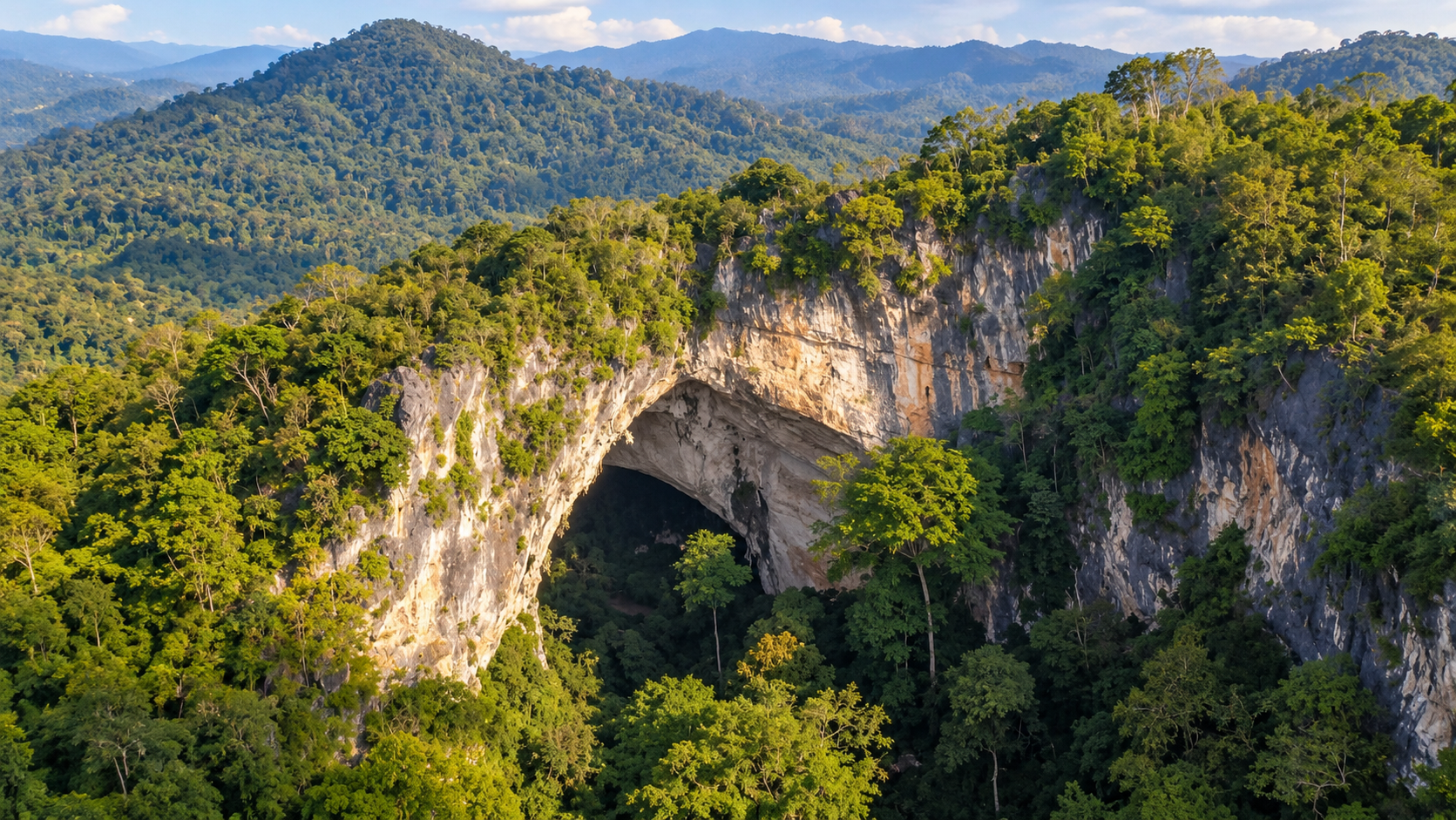
A mountain stream passes through the dramatic limestone formations of Tham Than Lot — a landscape that feels less like a conventional cave and more like a natural cathedral, with waterfalls descending through forest above and water continuing through darkness below.
Basic Information
- Name
- Chaloem Rattanakosin National Park
- Thai Name
- อุทยานแห่งชาติเฉลิมรัตนโกสินทร์
- Former Name
- Tham Than Lot National Park (อุทยานแห่งชาติถ้ำธารลอด)
- Province
- Kanchanaburi
- District
- Si Sawat
- Subdistrict
- Khao Chot
- Region
- Western Thailand
- Established
- 12 February 1980
- National Park Number
- Thailand’s 17th National Park
- Area
- Approximately 36,875 rai / 59 km²
- Landscape
- Limestone mountains · Forested valleys · Caves · Streams · Waterfalls · Natural rock formations
- Main Attractions
- Tham Than Lot Noi · Tham Than Lot Yai · Traitrung Waterfall · Than Ngoen Waterfall · Than Thong Waterfall · Nature-study trails
- Main Character
- A compact but remarkably dramatic western Thailand national park where streams disappear beneath limestone mountains, emerge through caves, and descend through forest as waterfalls
A Small Park With a Remarkable Landscape
Chaloem Rattanakosin National Park is one of Kanchanaburi’s smaller protected areas.
At approximately 36,875 rai, or about 59 square kilometres, it is compact compared with many of Thailand’s large national parks.
But size is not the point.
The park contains an unusually concentrated combination of limestone formations, caves, streams and waterfalls — a standout destination in ThailandLover’s Nature & Parks collection.
Its defining geological feature is Tham Than Lot — a system of limestone formations created by the interaction between rock and flowing water.
The result is a landscape of caves, natural arches, underground streams, forest trails and waterfalls.
The park was originally established as Tham Than Lot National Park on 12 February 1980 and later became known as Chaloem Rattanakosin National Park.
Today, the name may be formal and ceremonial.
But the landscape itself remains intensely natural.
Why Visit Chaloem Rattanakosin?
The Cave Is Only the Beginning
Many visitors come because they have heard of Tham Than Lot.
But the real experience is the journey between the attractions.
You walk beside water. You enter limestone. You emerge into forest. You climb toward a waterfall. You cross a stream. And eventually the mountain reveals another formation.
This is a park best experienced on foot.
Tham Than Lot Noi
The Cave Where the Stream Enters the Mountain
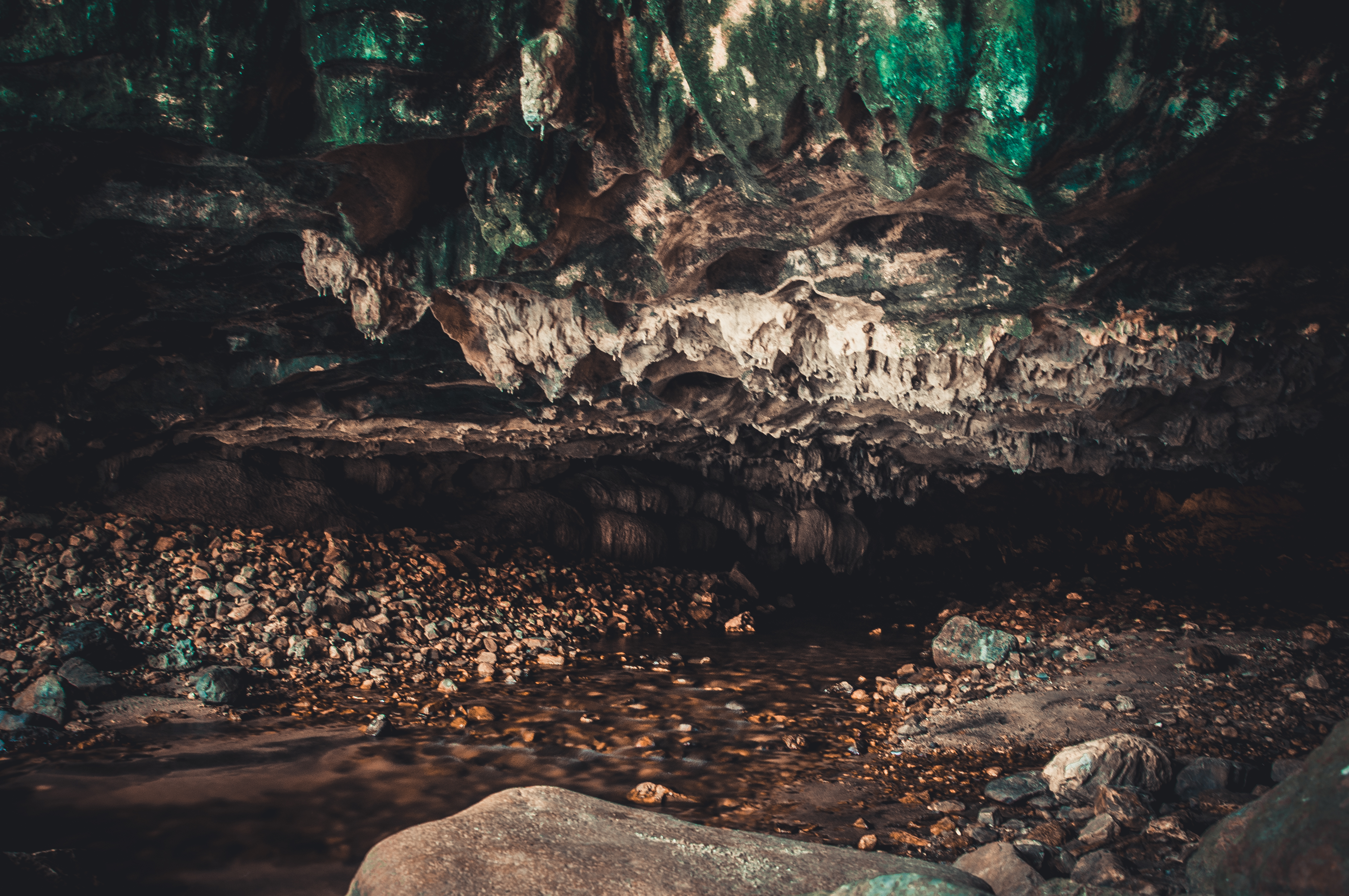
Tham Than Lot Noi is located only about 100 metres from the park headquarters.
The cave is approximately 300 metres long, with an entrance around 25 metres wide and 10 metres high.
A stream flows through the cave, creating a cool and humid environment even when temperatures outside are high.
Inside are stalactites, stalagmites and other limestone formations.
The combination of flowing water, rock formations and filtered light gives the cave its distinctive atmosphere.
The cave is not simply an underground chamber.
It is part of a hydrological system.
Water enters. Water flows. The mountain becomes a passage.
The Stream Inside Tham Than Lot Noi
Follow the Water
The stream running through the cave is one of the most important elements of the experience.
Rather than viewing the cave as a static geological object, visitors can see how water continues to shape the limestone environment.
The sound of running water becomes the soundtrack. The air becomes cooler. Light disappears. And the forest outside feels increasingly distant.
This transition from forest to cave is one of Chaloem Rattanakosin’s strongest experiences.
Architecture Made by Water
Limestone caves develop over extremely long periods.
Rainwater absorbs carbon dioxide as it moves through soil and vegetation. The slightly acidic water enters cracks in limestone. Over time, the rock is dissolved. Small fractures become passages. Passages become chambers. And underground water creates the formations that visitors see today.
At Tham Than Lot, this geological process has produced a particularly dramatic result.
The mountain has effectively become a bridge through which water travels.
Traitrung Waterfall
The Waterfall Beyond the Cave
After passing through Tham Than Lot Noi, the trail continues through forest toward Traitrung Waterfall.
The waterfall is approximately 1.5 kilometres from Tham Than Lot Noi.
It consists of several levels, with three principal tiers commonly described.
The trail follows the natural stream environment and gradually changes from cave landscape to open forest.
This transition is important.
You are no longer looking at a cave.
You are following the same water system into the forest.
The Trail to Traitrung
Forest, Stream and Limestone
The trail from Tham Than Lot Noi to Traitrung Waterfall passes through shaded forest.
Depending on season, visitors may encounter ferns, moss, mushrooms, bamboo, large trees, stream vegetation, birds, insects and limestone outcrops.
The Ministry of Natural Resources and Environment has specifically highlighted the 2.5-kilometre Tham Than Lot Noi–Traitrung–Tham Than Lot Yai nature trail as an ecological walking route where visitors can observe forest life, mushrooms and insects.
The best way to experience it is slowly.
Look down. Look up. Listen.
The forest is the attraction between the attractions.
Tham Than Lot Yai
The Natural Bridge
Tham Than Lot Yai is the geological centerpiece of the park.
Unlike a conventional cave with a narrow entrance and enclosed chamber, Tham Than Lot Yai resembles a gigantic natural bridge.
The limestone formation is approximately 60 metres wide and 60 metres long beneath the cave, with openings around 40 metres wide and 40 metres high.
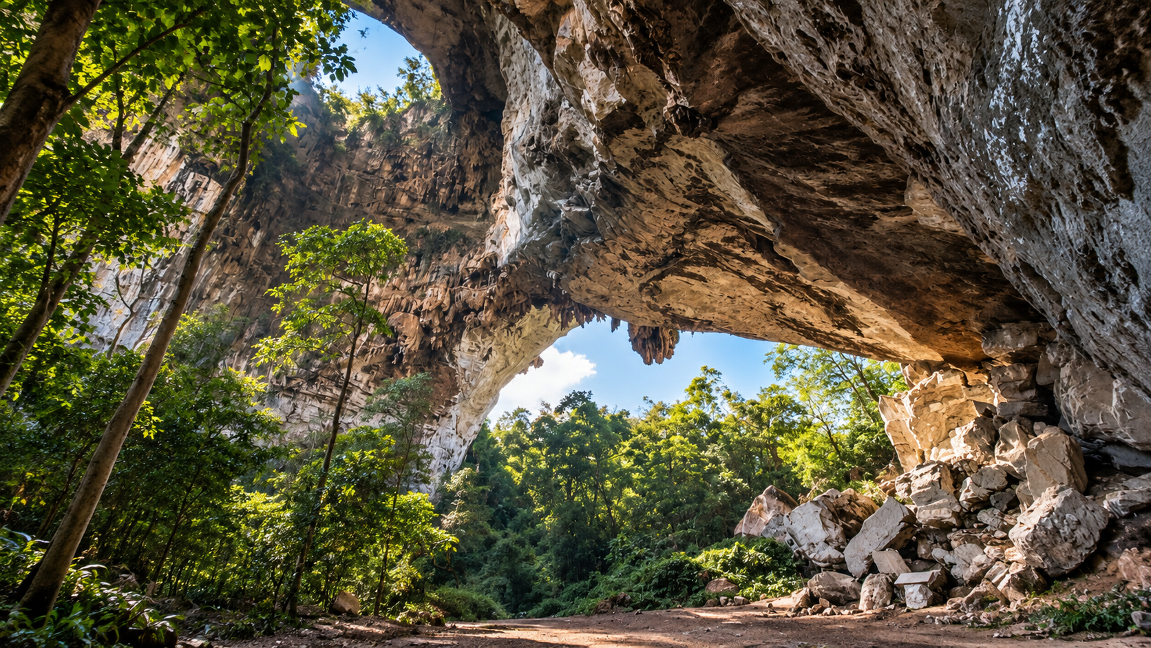
A large opening in the roof allows daylight to enter. Trees can grow inside.
A cave becomes a forest.
A mountain becomes an arch.
And sunlight enters the darkness from above.
A Cave With a Forest Inside
The Natural Skylight
One of Tham Than Lot Yai’s most remarkable characteristics is its large opening in the ceiling.
Sunlight enters from above. Vegetation grows on the cave floor. The interior therefore does not behave like a completely enclosed cave.
It becomes an intermediate environment between underground and above ground.
For photography, this is one of the strongest scenes in the park. Look for vertical limestone walls, trees growing inside the formation, shafts of daylight, human scale against the rock and shadows beneath the natural bridge.
When a Mountain Becomes a Bridge
Geology of Tham Than Lot
The Tham Than Lot formation is associated with the collapse and erosion of limestone.
Water gradually weakens and dissolves the limestone. Underground passages expand. Sections of the cave roof can eventually collapse. What remains can resemble a natural bridge.
This is why the formation is so visually distinctive. It is not an artificial arch. It is the surviving structure of a much larger geological process.
The Office of Natural Resources and Environmental Policy and Planning identifies Tham Than Lot Yai as a significant natural geological feature formed through limestone collapse and water erosion.
One Stream, Many Landscapes
The central story of Chaloem Rattanakosin is water.
The same basic force appears in different forms:
- Underground Water
- Inside Tham Than Lot Noi.
- Surface Water
- Along the forest trail.
- Falling Water
- At Traitrung, Than Ngoen and Than Thong waterfalls.
- Seasonal Water
- Changing with rainfall throughout the year.
The park can therefore be read as a single hydrological story.
Than Ngoen Waterfall
Seven Levels of Water
Than Ngoen Waterfall is described as a smaller waterfall system descending through approximately seven levels.
The first level is reached after a forest walk from the park headquarters. The route is around 1.8 kilometres as part of the park’s waterfall trail system.
The waterfall is more intimate than a giant single-drop waterfall. Its character comes from the repeated movement of water over rock.
Seven levels. One stream. One forest.
Than Thong Waterfall
Fifteen Levels Through the Forest
Than Thong Waterfall is the larger waterfall system associated with the second major walking route.
It is described as having approximately fifteen levels.
The first level can be reached after a shorter walk from the park headquarters than Than Ngoen.
The waterfall is particularly attractive during periods when the stream has sufficient water flow.
The many levels create a long sequence of small cascades rather than one single dramatic drop.
This makes it a landscape to explore rather than simply photograph from one viewpoint.
The Two Main Walking Routes
Route One
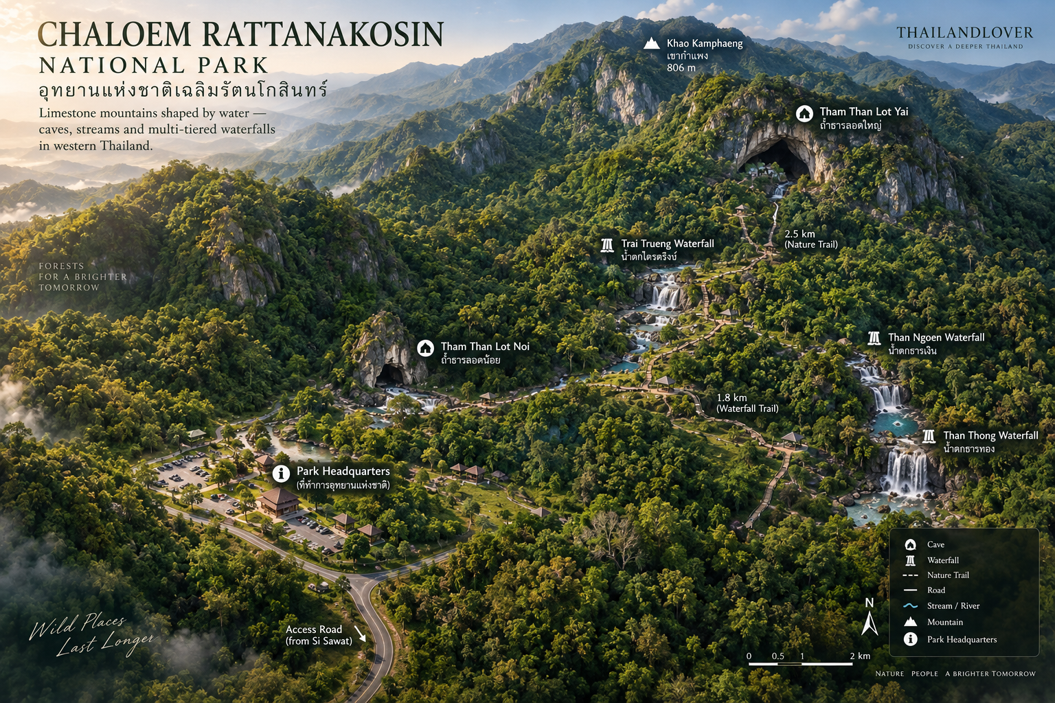
Tham Than Lot Noi → Traitrung Waterfall → Tham Than Lot Yai
Approximate total: 2.5 kilometres
Highlights: Tham Than Lot Noi, limestone formations, underground stream, forest trail, Traitrung Waterfall, Tham Than Lot Yai, natural bridge and cave skylight.
This is the signature Chaloem Rattanakosin experience.
Route Two
Park Headquarters → Than Ngoen → Than Thong
Approximate route: 1.8 kilometres
Highlights: forest, streams, Than Ngoen Waterfall, Than Thong Waterfall and multi-tiered cascades.
This route is more focused on the park’s waterfall landscape.
A Compact Western Forest
Although the park is relatively small, the forest remains important.
Its valleys retain moisture. Streams create riparian habitat. Limestone formations provide specialized microhabitats. And the surrounding mountains connect the park with the larger western forest landscape of Kanchanaburi.
This is part of why the park can support a surprisingly diverse range of plants, birds, insects and other wildlife.
Wildlife
Look for Signs Rather Than Guaranteed Sightings
The park’s forest provides habitat for wildlife typical of western Thailand.
Visitors may encounter forest birds, hornbills, muntjac, wild boar, macaques, langurs, civets, squirrels, reptiles, amphibians, butterflies and forest insects.
However, wildlife sightings are unpredictable.
Do not come expecting a wildlife safari.
Come expecting a living forest.
A bird call. Tracks in mud. A butterfly crossing the trail. A frog beside the stream. These are often the most authentic encounters.
Mushroom Season
When the Forest Floor Comes Alive
The rainy season can transform the forest floor. Moss becomes vivid. Ferns expand. Fungi appear around decaying wood and moist soil.
The 2.5-kilometre nature trail between Tham Than Lot Noi and Tham Than Lot Yai has been highlighted by the Ministry of Natural Resources and Environment as a particularly interesting route for observing mushrooms and small forest organisms.
This is not a destination for rushing.
The slower you walk, the more you see.
Birdwatching
Listen to the Canopy
The forest around the caves and waterfalls provides opportunities for birdwatching.
Early morning is generally the best time. Bring binoculars. Walk quietly. Pause near streams. Look toward the canopy rather than only along the trail.
The forest is often heard before it is seen.
A Cave With a Human Story
Tham Than Lot is not only a geological site. It also carries archaeological and historical significance.
Human remains have been discovered in the area around Tham Than Lot Yai, indicating ancient use of the cave environment.
The cave has also been associated with historical military movement through western Thailand. Local and government sources describe the area as part of routes used by Burmese forces and, later, Japanese military forces.
This makes the cave unusual. It is simultaneously a geological formation, an ecological landscape, an archaeological site and a historical route.
Ancient Human Remains
The Mountain as Shelter
The discovery of human skeletal remains around Tham Than Lot Yai indicates that the cave environment had significance for people long before the modern national park existed.
Some of these archaeological materials have been preserved and displayed outside the cave environment.
Visitors should understand that the site is not an archaeological excavation attraction. Its importance is that the landscape preserves evidence of how people interacted with these mountains in the past.
A Landscape Crossed by Armies
Western Thailand has historically been a corridor between the central Thai plain and Myanmar.
Mountain passes provided routes through the frontier landscape. Tham Than Lot is associated with this broader history.
The same terrain that allowed water to cut through limestone also provided routes through the mountains.
The cave therefore forms part of a much larger historical geography.
From Tham Than Lot to Chaloem Rattanakosin
The park was originally designated as Tham Than Lot National Park in 1980.
The park was later renamed Chaloem Rattanakosin National Park.
The old name remains widely used locally and in travel references.
This is why visitors may encounter both names — Chaloem Rattanakosin National Park and Tham Than Lot National Park.
They refer to the same protected area.
Kanchanaburi’s Mountain Landscape
Chaloem Rattanakosin sits within the broader western forest landscape of Kanchanaburi.
It is surrounded by other major protected areas including:
- Erawan National Park
- Khuean Srinagarindra National Park
- Sai Yok National Park
- Lam Khlong Ngu National Park
- Salak Phra Wildlife Sanctuary
Together, these protected areas create a much larger ecological landscape than the 59-km² park alone suggests.
This is important for understanding its conservation value.
Small by National Park Standards
At approximately 59 km², Chaloem Rattanakosin is small compared with Thailand’s largest national parks.
But its compact size is actually an advantage for visitors.
Several major natural features can be experienced within a relatively concentrated area.
Forest → Cave → Stream → Waterfall → Natural bridge
within a single walking itinerary.
That concentration gives the park a strong sense of narrative.
A ThailandLover Day
- 06:00–08:00
- Arrive early. The forest is cooler. Bird activity is higher. The light is softer.
- Morning
- Begin with Tham Than Lot Noi. Enter the cave. Follow the stream. Observe the limestone formations.
- Late Morning
- Continue along the forest trail toward Traitrung Waterfall. Take your time. Do not rush the 1.5-kilometre section.
- Midday
- Continue toward Tham Than Lot Yai. Spend time inside the natural bridge. Look upward toward the opening in the cave roof.
- Afternoon
- Return toward the park headquarters. If conditions and access allow, explore the Than Ngoen / Than Thong route.
- Late Afternoon
- Return to the main visitor area. The park becomes quieter. Forest sounds become more noticeable.
How to Photograph Chaloem Rattanakosin
- 01 — The Cave Entrance
- Use the entrance to create scale. A person can provide perspective, but keep the subject small.
- 02 — The Stream Inside the Cave
- Use a slower shutter speed if conditions permit. Look for reflections and texture.
- 03 — The Natural Bridge
- Shoot upward. The most interesting composition often includes the opening in the roof.
- 04 — Trees Inside Tham Than Lot Yai
- One of the park’s most unusual visual contrasts: stone, forest and sky in one frame.
- 05 — Waterfall Detail
- Look for water over limestone, moss, ferns, reflections, small cascades and wet rock texture.
Best Time to Visit
- November – February
- Best overall period. Cooler weather, comfortable hiking, lower humidity — good conditions for walking the cave and waterfall routes.
- June – October
- Green season. The forest becomes lush; moss and ferns become more visible; waterfalls are generally more impressive after rainfall. Trails can become slippery and some attractions may close for safety.
- March – May
- Hot + dry. Temperatures can become high, water levels can decrease, and visibility may be affected by regional haze.
Opening Hours
Published tourism information currently lists the park’s general visitor hours as approximately 06:00–18:00 daily.
However, other government tourism-planning material has published shorter general operating hours of 08:00–16:00.
This discrepancy means ThailandLover should not present either figure as an absolute guarantee.
Individual trails, caves, waterfalls, accommodation areas and seasonal attractions may have separate access conditions.
Seasonal Closures
Chaloem Rattanakosin has historically operated with seasonal restrictions on individual attractions rather than necessarily closing the entire park.
For example, DNP/TAT seasonal information has listed the Khao Kamphaeng campsite for annual closure from 1 February to 30 September in the relevant published schedule.
Conditions can change between years. Do not rely on an old closure calendar. Always check the current DNP information before travelling.
Entrance Fees
Published visitor information lists:
- Thai Visitors
- Adult 40 THB · Child 20 THB
- Foreign Visitors
- Adult 200 THB · Child 100 THB
Vehicle and other service charges may be separate. Fees are subject to change. Verify current rates before travel.
Accommodation & Camping
The park provides basic accommodation and camping facilities.
This makes an overnight visit possible for travellers who want to experience the forest beyond the daytime period.
At night, the cave disappears into darkness. The forest becomes louder. Insects become active. The temperature drops. And the absence of urban light becomes part of the landscape.
Confirm room availability, camping availability, current prices, check-in conditions and seasonal closures before travelling.
How to Get There
From Kanchanaburi City
Chaloem Rattanakosin National Park is approximately 97 kilometres from Kanchanaburi town by road.
A practical route is generally through the western/northwestern side of Kanchanaburi toward Nong Prue and then onward to Khao Chot.
Allow additional time for the final rural section.
From Bangkok
The journey from Bangkok is typically around 200 kilometres, depending on the route and starting point.
Bangkok → Nakhon Pathom → Kanchanaburi → Nong Prue → Khao Chot → Chaloem Rattanakosin
Driving is strongly recommended. Public transportation is possible only with additional local transfers.
By Public Transport
Travellers without a private vehicle can travel toward Nong Prue and arrange local transportation for the final section.
However, public transport is less convenient for exploring the park because attractions are separated by walking routes and local roads.
Private car = easiest · Hired driver = comfortable · Public transport = possible, but requires planning
Road & Trail Conditions
This Is Not a City Park
The main visitor area is relatively accessible. The deeper trails are different.
Expect uneven ground, tree roots, rocks, stream crossings, wet surfaces, slippery limestone and steep sections.
Good walking shoes are essential.
Safety
- Caves
- Never enter restricted cave areas. Follow park lighting and walkway systems. Do not climb formations. Do not touch stalactites or stalagmites.
- Waterfalls
- Rocks can become extremely slippery after rain. Never enter fast-moving water.
- Streams
- Water levels can rise quickly after heavy rainfall. Do not cross streams when conditions are unsafe.
- Hiking
- Carry water, proper shoes, a small first-aid kit, insect protection, rain protection and a phone/power bank. For longer or remote routes, follow park guidance regarding guides and registration.
Responsible Travel
Leave the Cave as You Found It
- Do not touch cave formations
- Do not break rocks or collect fossils
- Do not remove plants
- Do not feed wildlife
- Do not leave food waste or plastic
- Do not make loud noise
- Do not enter closed areas
- Do not write on limestone
Caves are extremely slow-growing environments.
A mark made in seconds can remain for generations.
Who Is Chaloem Rattanakosin For?
Perfect for
- Nature Travellers
- Who want a compact but immersive forest experience.
- Photographers
- Who enjoy unusual geological landscapes.
- Hikers
- Who prefer walking through forests rather than visiting roadside viewpoints.
- Geology Enthusiasts
- Who want to understand limestone landscapes.
- History Travellers
- Who enjoy destinations where natural and human history overlap.
- Families with Older Children
- Who can handle moderate walking.
- Slow Travellers
- Who prefer one strong landscape over many commercial attractions.
Who Should Skip It?
If you want luxury facilities, easy access everywhere, large commercial attractions, guaranteed swimming, short walks only or resort-style tourism, this may not be the right destination.
Chaloem Rattanakosin rewards curiosity and walking.
Nearby Destinations
- Kanchanaburi City
- A natural starting point for exploring western Thailand.
- Erawan National Park
- Famous for its multi-tiered waterfall and emerald pools — see Erawan National Park.
- Khuean Srinagarindra National Park
- A larger mountain and reservoir landscape north of the park — see Khuean Srinagarindra.
- Sai Yok
- A major western Thailand destination known for waterfalls, river landscapes and historical sites — see Sai Yok National Park.
- Salak Phra Wildlife Sanctuary
- A significant protected forest landscape near Kanchanaburi.
The Smaller Park Inside a Bigger Forest Story
The most interesting way to understand Chaloem Rattanakosin is not to isolate it.
Look at the map. Kanchanaburi is surrounded by protected forests: Erawan, Sai Yok, Khuean Srinagarindra, Lam Khlong Ngu, Salak Phra, Chaloem Rattanakosin.
Each protected area has a different landscape. Together they form a much larger conservation story.
Chaloem Rattanakosin is the cave-and-water chapter.
FAQ
- What is Chaloem Rattanakosin National Park famous for?
- Chaloem Rattanakosin National Park in Kanchanaburi is famous for Tham Than Lot — limestone caves and a dramatic natural bridge where a mountain stream passes through stone — together with forest trails and waterfalls including Traitrung, Than Ngoen and Than Thong.
- Is Chaloem Rattanakosin the same as Tham Than Lot National Park?
- Yes. The park was originally established as Tham Than Lot National Park in 1980 and later renamed Chaloem Rattanakosin National Park. Both names refer to the same protected area.
- Where is Chaloem Rattanakosin National Park?
- The park is in Khao Chot Subdistrict, Si Sawat District, Kanchanaburi, Western Thailand. It is approximately 97 kilometres from Kanchanaburi town by road.
- What is the best walking route in Chaloem Rattanakosin?
- The signature route is Tham Than Lot Noi → Traitrung Waterfall → Tham Than Lot Yai, approximately 2.5 kilometres. A second waterfall-focused route runs from the park headquarters toward Than Ngoen and Than Thong.
- When is the best time to visit Chaloem Rattanakosin National Park?
- November–February is generally the best overall period for cooler weather and comfortable hiking. June–October brings greener forest and stronger waterfalls, but trails can become slippery and some attractions may close for safety.
- How much is the entrance fee to Chaloem Rattanakosin National Park?
- Published visitor information lists Thai visitors at 40 THB adult / 20 THB child and foreign visitors at 200 THB adult / 100 THB child. Vehicle and other service charges may be separate, and fees can change.
Quick Facts
- Name
- Chaloem Rattanakosin National Park
- Thai
- อุทยานแห่งชาติเฉลิมรัตนโกสินทร์
- Former Name
- Tham Than Lot National Park
- Province
- Kanchanaburi
- District
- Si Sawat
- Subdistrict
- Khao Chot
- Established
- 12 February 1980
- National Park Number
- 17
- Area
- 36,875 rai / approximately 59 km²
- Main Landscape
- Limestone mountains, caves, streams, waterfalls and forest
- Signature Attraction
- Tham Than Lot
- Main Cave Route
- Tham Than Lot Noi → Traitrung Waterfall → Tham Than Lot Yai
- Nature Trail
- Approximately 2.5 km
- Tham Than Lot Noi
- Approximately 300 m long
- Tham Than Lot Yai
- Natural-bridge formation approximately 60 m wide, with a large roof opening and forest growing inside
- Traitrung Waterfall
- Approximately 1.5 km from Tham Than Lot Noi
- Than Ngoen
- Approximately 7 levels
- Than Thong
- Approximately 15 levels
- General Visitor Hours
- Published sources vary; approximately 06:00–18:00 is currently listed by tourism information, while some government material lists 08:00–16:00
- Thai Entrance Fee
- 40 THB adult / 20 THB child
- Foreign Entrance Fee
- 200 THB adult / 100 THB child
- Best Overall Season
- November–February
- Best For
- Caves, waterfalls, forest walking, geology, photography and slow nature travel
Location
Find Chaloem Rattanakosin National Park
Khao Chot, Si Sawat, Kanchanaburi, Western Thailand