



National Park · Chiang Mai
Sri Lanna National Park
อุทยานแห่งชาติศรีลานนา
Mountains, Forests & the Great Mae Ngat Reservoir
Mae Taeng · Chiang Dao · Phrao · Northern Thailand
North of Chiang Mai, beyond the familiar routes to Chiang Dao and the valleys of Phrao, lies a vast protected landscape of forests, limestone mountains, waterfalls and water.
Where Mountains Meet the Water
North of Chiang Mai, beyond the familiar routes to the mountains of Chiang Dao and the valleys of Phrao, lies a vast protected landscape of forests, limestone mountains, waterfalls and water. This is Sri Lanna National Park.
One of northern Thailand’s largest national parks, Sri Lanna stretches across Mae Taeng, Chiang Dao and Phrao districts, protecting an extensive section of the Phi Pan Nam mountain system.
At its heart lies the Mae Ngat Somboon Chon Reservoir, where forested mountains descend toward a vast inland lake. Elsewhere, nine-tiered waterfalls disappear into mountain forest, limestone caves extend beneath the hills, and remote nature trails cross different forest ecosystems.
Sri Lanna is therefore not simply a place to visit a waterfall.
A landscape of mountains, forests, water and wilderness.
At a Glance
- ~1,406 km²
- Park area — approximately 878,750 rai.
- 1989
- Designated 1 August, as Thailand’s 60th national park.
- 1,718 m
- Doi Chom Hot, the park’s highest point.
- 3 districts
- Mae Taeng, Chiang Dao and Phrao, Chiang Mai.
- 9 tiers
- Mon Hin Lai, the park’s signature waterfall.
- Official Name
- Sri Lanna National Park
- Thai Name
- อุทยานแห่งชาติศรีลานนา
- Alternative Romanisation
- Si Lanna National Park
- Province
- Chiang Mai
- Districts
- Mae Taeng, Chiang Dao & Phrao
- Established
- 1 August 1989 · National Park No. 60
- Area
- Approximately 878,750 rai / 1,406 km²
- Mountain System
- Phi Pan Nam Range
- Elevation
- Approximately 400–1,718 m
- Highest Peak
- Doi Chom Hot
- Major Water Body
- Mae Ngat Somboon Chon Reservoir
- Main Character
- Mountain forest, reservoir, waterfalls, caves and watersheds
- Signature Experience
- Mae Ngat reservoir and floating stays
Sri Lanna was formally designated as Thailand’s 60th national park on 1 August 1989. The park covers approximately 878,750 rai, or about 1,406 square kilometres, making it one of the largest protected landscapes in northern Thailand.
Why Sri Lanna Is Special
Many mountain parks are defined primarily by their peaks. Others are known for waterfalls or forests. Sri Lanna combines all three — with a major reservoir at its centre. Its landscape can be understood through four elements:
- 01 · The Mountains
- High ridges and limestone formations create the park’s dramatic terrain.
- 02 · The Forest
- Different forest ecosystems cover the mountains and provide important watershed habitat.
- 03 · The Water
- Streams descend from the mountains toward the Mae Ngat reservoir and the upper Ping River system.
- 04 · The Reservoir
- Mae Ngat Somboon Chon transforms the centre of the landscape into an enormous inland water environment.
Together, these elements make Sri Lanna one of Chiang Mai’s most geographically diverse national parks.
The Mountains of Sri Lanna
The Phi Pan Nam landscape
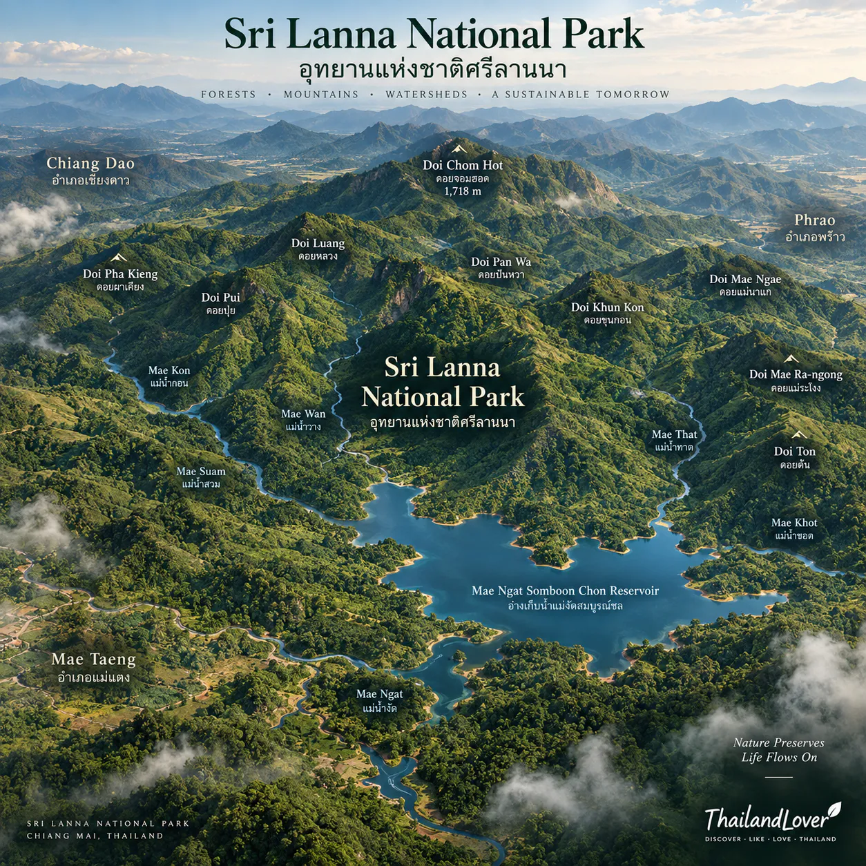
Sri Lanna occupies a broad mountainous section of the Phi Pan Nam mountain system. The terrain is rugged and complex, with numerous ridges and peaks, including:
- Doi Wiang Pha
- Doi Luang
- Doi Pui
- Doi Pan Wa
- Doi Pha Khiang
- Doi Khun Kon
- Doi Mae Ra Ngong
- Doi Mae Ngae
- Doi Ton
Elevation ranges from approximately 400 metres to 1,718 metres above sea level. The highest point is Doi Chom Hot.
These mountains are more than scenery. They are the source of streams that feed the Mae Ngat reservoir and the upper Ping River system.
Mae Ngat Somboon Chon Reservoir
อ่างเก็บน้ำแม่งัดสมบูรณ์ชล · the water heart of Sri Lanna
The Mae Ngat Somboon Chon Reservoir is the most recognisable landscape associated with Sri Lanna National Park. Created by the Mae Ngat Somboon Chon Dam, it occupies a broad valley surrounded by forested mountains.
From the shore, the landscape can appear almost lake-like. Travel farther into the reservoir by boat and the experience changes completely. The mountains become the dominant feature. Water replaces roads. Forest-covered slopes rise from the shoreline. And floating accommodation becomes part of the experience.
One of the most distinctive ways to experience northern Thailand — without climbing a mountain.
A Night on the Reservoir
Floating raft houses
One of Sri Lanna’s signature experiences is staying in floating accommodation on Mae Ngat Reservoir. Instead of returning to Chiang Mai after a day in the mountains, you stay overnight on the water. The experience is deliberately simple:
- 01
- Boat ride across the reservoir
- 02
- Forest-covered mountains on every side
- 03
- Arrival at your floating raft
- 04
- Dinner over the water
- 05
- A quiet night
- 06
- Morning mist
- 07
- Boat back through the reservoir
The Reservoir at Sunrise
Early morning is one of the most atmospheric times to experience Mae Ngat. Mist can gather above the water and between the surrounding mountains, particularly in cooler conditions. The lake becomes almost completely still, and as sunlight reaches the ridges, the landscape changes from blue-grey to green and gold.
This is not a dramatic viewpoint in the traditional sense. It is a slow landscape experience. For photographers, the combination of:
- Still water and reflections
- Mountain silhouettes
- Morning mist
- Floating structures
- Soft northern light
makes the reservoir one of Sri Lanna’s strongest visual subjects.
Blue-grey at dawn. Green and gold by breakfast.
Boat Trips
Explore the reservoir from the water
A boat journey is the natural way to experience Mae Ngat. From the reservoir access area, long-tail boats carry visitors toward floating accommodation and other points on the lake. Depending on the arrangement, you may spend several hours on the water or travel directly to an overnight raft.
Activities around the reservoir can include:
- Sightseeing and boat trips
- Kayaking
- Swimming where permitted
- Fishing under applicable rules
- Overnight floating accommodation
Conditions change with water level, weather, park regulations and individual operator arrangements. Always follow current instructions on where swimming and water activities are permitted.
Mon Hin Lai Waterfall
น้ำตกม่อนหินไหล · nine levels in the mountain forest
Deep in the Mae Ngat forest area of Phrao District lies one of Sri Lanna’s most distinctive waterfalls: Mon Hin Lai.
The waterfall has nine levels, flowing over steep mountain terrain. The tiers create a sequence of rock cascades rather than a single vertical drop, and the upper section offers views toward the surrounding landscape of Phrao.
It is at its most attractive in the wetter months, when the forest is lush and the water flow is stronger. The Department of National Parks (DNP) identifies Mon Hin Lai as one of the park’s major natural attractions.
More Forest Waterfalls
- Huai Mae Ra Ngong Waterfall · water in the deep forest
- Less developed than the reservoir tourism area, and better suited to travellers interested in natural landscapes than facilities. In wetter periods, the streams become powerful and the forest intensely green; in drier conditions, exposed rocks and smaller pools become more visible.
- Huai Pa Phlu Waterfall · a seven-tier forest waterfall
- A medium-sized waterfall of around seven levels on the Phrao side of the park, surrounded by relatively intact forest. Expect a forest environment rather than a developed attraction — this is a more adventurous style of travel than the reservoir. DNP lists Huai Pa Phlu among Sri Lanna’s waterfall attractions.
Sri Lanna’s waterfalls change with the rain. Explore them by season, rather than judging them from a single photograph.
Limestone Caves
The world beneath Sri Lanna
Sri Lanna’s mountains contain extensive limestone formations, which have created numerous caves beneath the forest. The most significant documented cave systems are Nong Pha Cave, Pha Daeng Cave and Phet Cave.
Inside, water has slowly shaped the limestone into:
- Stalactites
- Stalagmites
- Columns
- Underground chambers
Nong Pha Cave
An underground limestone world
Nong Pha Cave is one of Sri Lanna’s better-known cave systems. It extends for approximately 800 metres, with multiple chambers and passages, stalactites and stalagmites, and larger chambers where limestone formations have developed over long periods.
Bats also inhabit the cave, which makes Nong Pha interesting not only as a geological attraction but also as an underground ecosystem.
Pha Daeng & Phet Caves
Limestone beneath Chiang Dao’s forest
Pha Daeng Cave lies in the Ping Khong area of Chiang Dao District, with limestone formations and large chambers. Nearby is Phet Cave, associated with old local-use features, including a traditional pounding mortar.
Together, these caves show how geological and human history overlap within Sri Lanna’s mountain landscape.
Forests of Sri Lanna
From deciduous forest to highland forest
Because of its wide elevation range, Sri Lanna contains several forest ecosystems:
- Mixed deciduous forest
- Common at lower and intermediate elevations. It changes noticeably with the seasons and can become relatively dry in the hot season.
- Dry dipterocarp forest
- Characteristic of the drier mountain slopes.
- Moist evergreen forest
- Found where more moisture is available.
- Hill evergreen forest
- Associated with higher elevations and cooler conditions.
The result is a remarkable ecological gradient within a single protected area.
The Park as a Watershed
Where the upper Ping begins to gather
Sri Lanna is an important watershed landscape. Streams rising in its mountains include:
- Mae Ngat
- Mae Khon
- Mae Wan
- Mae Suam
- Mae That
- Mae Khot
These waterways eventually feed the Mae Ngat reservoir and the upper Ping River system. DNP describes Sri Lanna as an important forest and watershed area for the upper Ping River.
The forest acts as a natural water-storage and filtration system, which is why Sri Lanna’s conservation value extends far beyond its tourism attractions.
Protect the forest, and you protect the water downstream.
Wildlife
A large forest habitat
Sri Lanna’s size and varied elevations provide habitat for a wide range of wildlife. Recorded forest fauna include:
- Wild boar and sambar deer
- Northern red muntjac
- Macaques and gibbons
- Serow
- Civets
- Siamese hare
- Numerous forest birds
Historical species records also include large carnivores such as tiger and Asian black bear within the broader protected forest ecosystem.
Sri Lanna is a protected forest, not a safari park.
A species list is not a promise of sightings. The most realistic encounters are birds, butterflies, small mammals, forest reptiles and amphibians — along with signs of larger animals.
Birdwatching
Sri Lanna’s elevation range and forest diversity make it interesting for birdwatchers. Look for birds around:
- Reservoir edges
- Forest trails
- Watercourses
- Evergreen forest
- Mixed deciduous forest
Early morning is generally the best time. Instead of walking quickly from one attraction to the next, stop and listen.
In a large forest, a birdcall can reveal more than a distant glimpse.
Nature Trails
Sri Lanna has several nature-study routes in different parts of the park:
- Doi Kio Du
- A relatively short route of around 2 km, designed to show forest ecology and forest recovery.
- Huai Kum
- A trail around the Huai Kum ranger area, passing through different forest types.
- Mon Hin Lai
- A forest trail through the mountain environment around the waterfall.
- Mae Wa
- A shorter route near the park headquarters, mainly through dry dipterocarp forest.
You don’t need to climb the highest mountain to understand Sri Lanna. Its ecology can be read directly from the forest floor.
The Landscape Along Route 1150
One of the park’s scenic drives
The road connecting Chiang Dao and Phrao through the Sri Lanna landscape is a particularly rewarding way to see the park. Along parts of the route, forest alternates with steep limestone mountains, and the scenery grows increasingly remote as you leave the main highway.
For travellers who prefer a road trip to a fixed attraction, this can be the best way to experience Sri Lanna. Some sections of Route 1150 have historically had rougher surfaces, so check current road conditions before choosing it as a cross-mountain route.
Doi Pha Sam Sao
One of the park’s most striking geological features is the Doi Pha Sam Sao limestone range. Its mountains rise sharply above the surrounding forest, creating dramatic silhouettes along parts of the Chiang Dao–Phrao landscape.
A reminder that Sri Lanna is not simply a reservoir park — the reservoir occupies only one part of a much larger mountain landscape.
Climate
Sri Lanna has a tropical monsoon climate with three broadly recognisable seasons.
- November – February · Cool season
- Generally the most comfortable period for mountain travel. Higher elevations can be distinctly cool at night and in the early morning. A good time for hiking, camping, photography, forest exploration and morning mist.
- March – May · Hot season
- Temperatures rise considerably and lower elevations can become hot and dry. Forest fires and smoke can also be significant in northern Thailand at this time — check current air quality and park restrictions before visiting.
- June – October · Rainy season
- Forests turn greener, streams and waterfalls carry more water and the reservoir landscape becomes especially lush. Rain can also bring slippery trails, muddy roads, strong streams, cave-access limits and temporary attraction closures — beautiful, but less predictable.
When to Visit
- First visit
- November–February — a good balance of comfortable mountain weather and outdoor activities.
- Waterfalls
- July–October can bring stronger water flow, subject to rainfall and access.
- Mae Ngat reservoir
- Attractive all year, but weather and water conditions shape the experience.
- Wildlife & birds
- Early morning matters more than any particular month.
Getting There
From Chiang Mai
Sri Lanna is roughly 65 km north of Chiang Mai, although the actual distance depends on which part of the park you are visiting. There is no single entrance that represents the whole park — it is a large protected landscape spread across three districts.
- Highway 107 · Chiang Mai–Fang
- Follows the Ping River through the Chiang Dao area and gives access to the western and northern sections of the park.
- Highway 1001 · Chiang Mai–Phrao
- Crosses the southern and eastern side of the park landscape. The principal route to Phrao, Mae Ngat and Mon Hin Lai.
- Highway 1150 · Chiang Dao–Phrao
- Crosses more remote, mountainous country and can be particularly scenic. Check road conditions before travelling, especially in the rainy season.
A Perfect Sri Lanna Day
Reservoir + forest
- Morning
- Chiang Mai → Mae Ngat Somboon Chon Dam → boat across the reservoir → floating raft area.
- Late morning
- Explore the reservoir and surrounding mountains.
- Lunch
- At a floating restaurant or raft, depending on current availability.
- Afternoon
- Return by boat → forest drive → short nature walk.
- Evening
- Return to Chiang Mai.
The Better Experience: Two Days
Water below, mountains above
- Day 1 · The Reservoir
- Chiang Mai → Mae Ngat Somboon Chon Dam → long-tail boat → floating accommodation. Watch the sunset over the reservoir and spend the night on the water.
- Day 2 · The Mountains
- Early morning on the reservoir → boat back → forest drive → nature trail → continue toward Phrao. If conditions and access permit, visit the Mon Hin Lai area, then return to Chiang Mai.
Two days reveal Sri Lanna’s two very different personalities: water below, and mountains above.
Staying on the Water
What to expect
Floating accommodation on Mae Ngat is not a conventional hotel. The appeal is the setting. Expect:
- Basic-to-comfortable rooms, depending on the operator
- Meals arranged through the raft
- Boat transfers
- Mountain views
- Limited connectivity in some areas
- Natural surroundings and quiet evenings
Some rafts offer kayaking or swimming. Always check current facilities and safety rules with the operator before booking.
Travel Tips
- Plan by area
- Sri Lanna is not a small park. At more than 1,400 km², its attractions can be widely separated.
- Choose your priority
- Reservoir, waterfall, cave or forest trail? Trying to do everything in one day can mean spending most of it driving.
- Check Mon Hin Lai’s status
- Access can be seasonal or temporarily restricted.
- Bring proper footwear
- Especially for waterfalls, caves and forest trails.
- Carry insect protection
- Forest environments can have mosquitoes and other insects.
- Check before entering caves
- Rain can rapidly change cave and stream conditions.
- Respect the reservoir
- Swim only where permitted and follow boat operators’ safety instructions.
- Don’t feed wildlife
- Sri Lanna is a protected ecosystem.
Bua Tong Waterfall Is Not in Sri Lanna
A common online mix-up
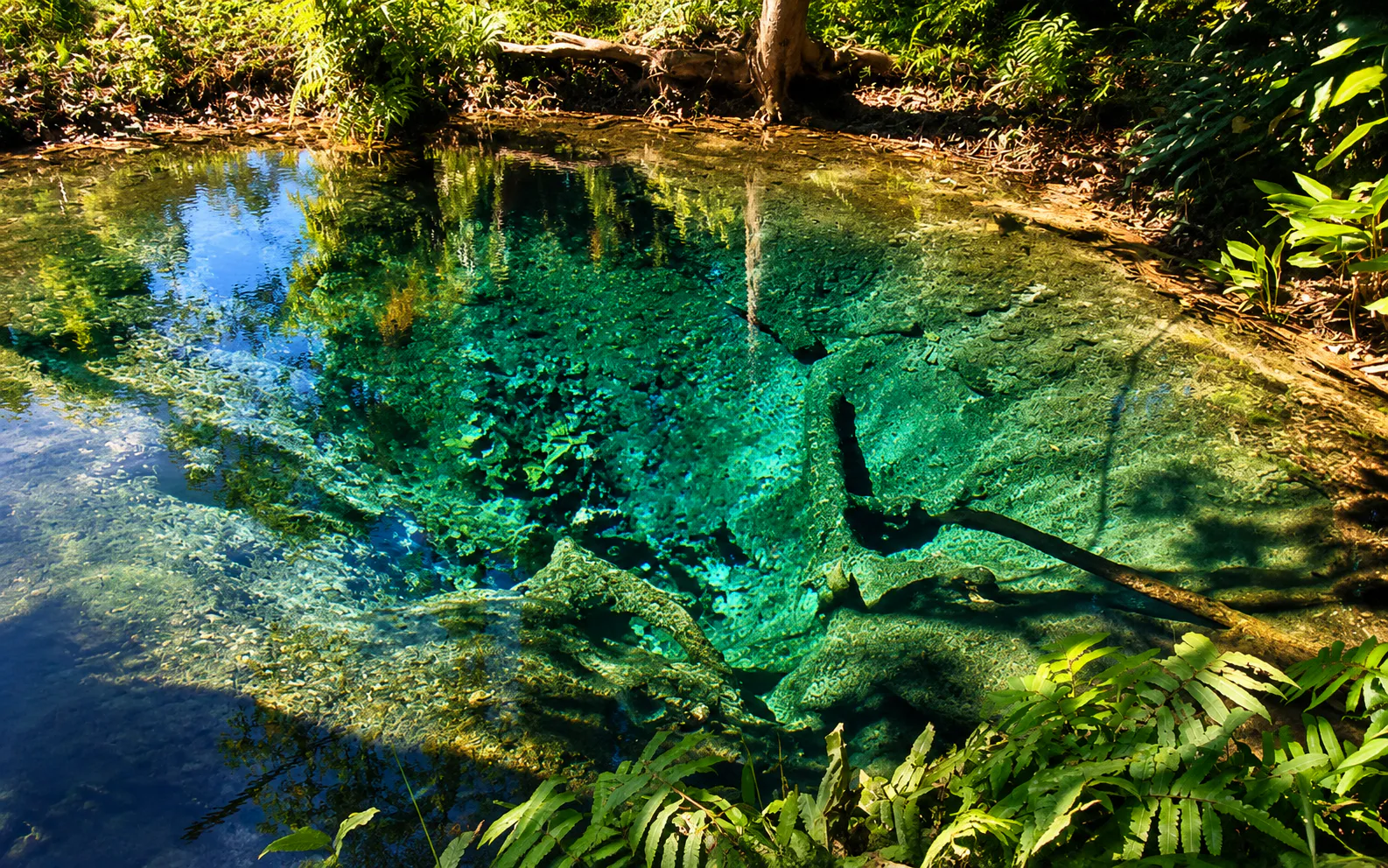
Bua Tong Waterfall and the Seven-Colored Spring — the famous “Sticky Waterfall” — are often described alongside Sri Lanna because they lie close by and share the same broader forest landscape.
However, they are formally part of Bua Tong–Nam Phu Chet Si Forest Park, not Sri Lanna National Park.
Responsible Travel
Sri Lanna is a large watershed forest, and every visitor shares responsibility for it.
Do
- Stay on designated trails and follow park instructions
- Carry your rubbish out
- Use established camping areas
- Keep noise low and respect wildlife
- Follow cave-access rules
- Follow reservoir safety instructions
Avoid
- Collecting plants or rocks
- Feeding wildlife
- Touching cave formations
- Entering restricted forest areas
- Swimming in unsafe areas
- Lighting fires outside designated areas
- Leaving food waste behind
The forest is the infrastructure that makes the whole landscape possible.
Who Is Sri Lanna For?
Ideal for
- Nature lovers
- Large forests and varied landscapes.
- Road-trip travellers
- Several routes cross the park’s mountainous terrain.
- Couples
- Floating accommodation offers a slower overnight experience.
- Photographers
- Mountains, reservoir, mist and waterfalls.
- Adventure travellers
- Caves, remote waterfalls and forest trails.
- Slow travellers
- Especially those who would rather stay on the reservoir than return to Chiang Mai.
- Families
- The Mae Ngat reservoir can be easier to enjoy than a strenuous mountain trek, subject to current safety conditions.
Sri Lanna vs. Chiang Mai’s Famous Mountain Parks
Sri Lanna has a different identity.
- Doi Inthanon
- Associated with Thailand’s highest mountain.
- Doi Suthep–Pui
- Closely tied to Chiang Mai’s urban landscape and cultural landmarks.
- Doi Chiang Dao
- Known for its dramatic limestone mountain and high-altitude ecosystem.
- Sri Lanna
- Defined by the relationship between mountain, forest, water and reservoir.
Its most memorable experience may not be reaching a summit. It may simply be sitting on a floating raft while the mountains disappear into the evening mist.
Essential Facts
- Location
- Chiang Mai Province, Northern Thailand
- Districts
- Mae Taeng, Chiang Dao and Phrao
- Established
- 1 August 1989 · Thailand’s 60th national park
- Area
- Approximately 878,750 rai / 1,406 km²
- Mountain system
- Phi Pan Nam Range
- Elevation
- Approximately 400–1,718 m
- Highest point
- Doi Chom Hot
- Main reservoir
- Mae Ngat Somboon Chon Reservoir
- Signature waterfall
- Mon Hin Lai — nine tiers
- Major cave
- Nong Pha Cave
- Other cave areas
- Pha Daeng Cave and Phet Cave
- Forest types
- Mixed deciduous, dry dipterocarp, moist evergreen and hill evergreen
- Main watershed
- Upper Ping River system
- Best overall season
- November–February
- Best waterfall period
- Generally the wetter months, subject to access and rainfall
Frequently Asked Questions
- What is Sri Lanna National Park?
- One of northern Thailand’s largest national parks, north of Chiang Mai — limestone mountains, several forest types, waterfalls, caves and the Mae Ngat Somboon Chon Reservoir. A landscape of mountains, forest, water and wilderness rather than a single attraction.
- Where is it, and how large is it?
- Mae Taeng, Chiang Dao and Phrao districts of Chiang Mai, roughly 65 km north of the city depending on the area. About 878,750 rai, or 1,406 km². Designated 1 August 1989 as Thailand’s 60th national park.
- Can I stay overnight on the reservoir?
- Yes — floating raft houses on Mae Ngat, reached by long-tail boat, are Sri Lanna’s signature stay. They are run by local providers, so standards, prices and availability vary. Check and book before you go.
- Is Mon Hin Lai Waterfall open?
- It can be seasonally or temporarily restricted. The nine-tier waterfall in Phrao District is remote, reached via the Chiang Mai–Phrao route and a rough access road. Check the latest park announcement before travelling.
- Is Bua Tong Sticky Waterfall inside Sri Lanna?
- No. Bua Tong and the Seven-Colored Spring belong to Bua Tong–Nam Phu Chet Si Forest Park — nearby and easy to combine with a Sri Lanna trip, but a separate protected area.
- When is the best time to visit?
- November to February for cool weather, morning mist and hiking. July to October for stronger waterfalls, subject to rainfall and access. March to May can bring heat, smoke and wildfire restrictions.
- How do I get there from Chiang Mai?
- There is no single entrance. Highway 107 serves the Chiang Dao side, Highway 1001 leads to Mae Ngat, Phrao and Mon Hin Lai, and Highway 1150 links Chiang Dao and Phrao through remote mountain country.
More of Chiang Mai’s Wild Parks
- Bua Thong–Nam Phu Chet Si
- The climbable “Sticky Waterfall” and Seven-Colored Spring — Sri Lanna’s closest neighbour.
- Doi Wiang Pha National Park
- Pine forest and sunrise ridges along the Chiang Mai–Chiang Rai border.
- Huai Nam Dang National Park
- The famous sea of mist at Doi Kiew Lom, on the road to Pai.
- Doi Suthep–Pui National Park
- Chiang Mai’s own mountain, with temples, waterfalls and forest above the city.
- Doi Inthanon National Park
- Thailand’s highest summit — the classic Chiang Mai mountain park.
Location
Find Sri Lanna National Park
Mae Taeng, Chiang Dao & Phrao, Chiang Mai · Mae Ngat Somboon Chon Reservoir lies at the park’s heart