


National Park · Chiang Mai
Doi Suthep–Pui National Park
อุทยานแห่งชาติดอยสุเทพ–ปุย
The Mountain Behind Chiang Mai
Mueang Chiang Mai · Mae Rim · Hang Dong · Northern Thailand
A vast mountain of forests, waterfalls, highland villages and Wat Phra That Doi Suthep — the green backdrop where Chiang Mai’s urban life meets Northern Thailand’s hills.
The Mountain Behind Chiang Mai
There is a mountain that quietly defines Chiang Mai.
Rising directly behind the city, Doi Suthep–Pui National Park is much more than the home of Wat Phra That Doi Suthep. It is a vast mountain landscape of forests, waterfalls, highland villages, viewpoints and wildlife — a green backdrop that connects Chiang Mai’s urban life with the mountains of Northern Thailand.
For first-time visitors, Doi Suthep may begin with a temple. Stay longer, and the mountain reveals another side of Chiang Mai.
Higher roads lead into cooler forests. Waterfalls hide among the trees. Highland communities sit along mountain ridges. In the right season, the hills turn pink with Thai cherry blossoms, while mornings can bring mist rolling across the surrounding valleys.
This is Doi Suthep–Pui — one of the most accessible mountain landscapes in Northern Thailand, and one of the places where Chiang Mai and nature meet most naturally.
Doi Suthep–Pui National Park at a Glance
- Official Name
- Doi Suthep–Pui National Park
- Thai Name
- อุทยานแห่งชาติดอยสุเทพ–ปุย
- Province
- Chiang Mai
- Region
- Northern Thailand
- National Park Number
- 24th National Park of Thailand
- Established
- 1981 (expanded 1982)
- Original Area
- 100,662 rai
- Expanded Area
- Approximately 163,162.50 rai / 261 km²
- Highest Peak
- Doi Pui — 1,685 metres
- Major Mountain
- Doi Suthep — approximately 1,601 metres
- Mountain Range
- Thanon Thong Chai Range
- Nearest Major City
- Chiang Mai
- Best Known For
- Wat Phra That Doi Suthep, Doi Pui, Khun Chang Kian, waterfalls, mountain forests
The park was formally established in 1981 and subsequently expanded in 1982. The expanded park covers approximately 163,162.50 rai, or about 261 km².
Why Doi Suthep–Pui Matters
Doi Suthep–Pui occupies a unique position among Thailand’s national parks. Many parks require a journey deep into the countryside before visitors reach the forest.
Doi Suthep–Pui is different. The mountain rises immediately behind Chiang Mai, making it one of the most accessible protected mountain landscapes in the country. The foothills are only a short distance from the city, yet the landscape quickly changes from urban Chiang Mai to forest, mountain roads and highland environments.
That proximity gives the park an unusual character. It is simultaneously:
- A natural watershed
- A mountain forest
- A wildlife habitat
- A cultural landscape
- A spiritual landscape
- A recreational destination
- One of Chiang Mai’s defining geographical features
It is not simply a national park outside Chiang Mai. It is part of Chiang Mai itself.
The Geography
Doi Suthep–Pui forms part of the Thanon Thong Chai mountain range, a major mountain system of Northern Thailand.
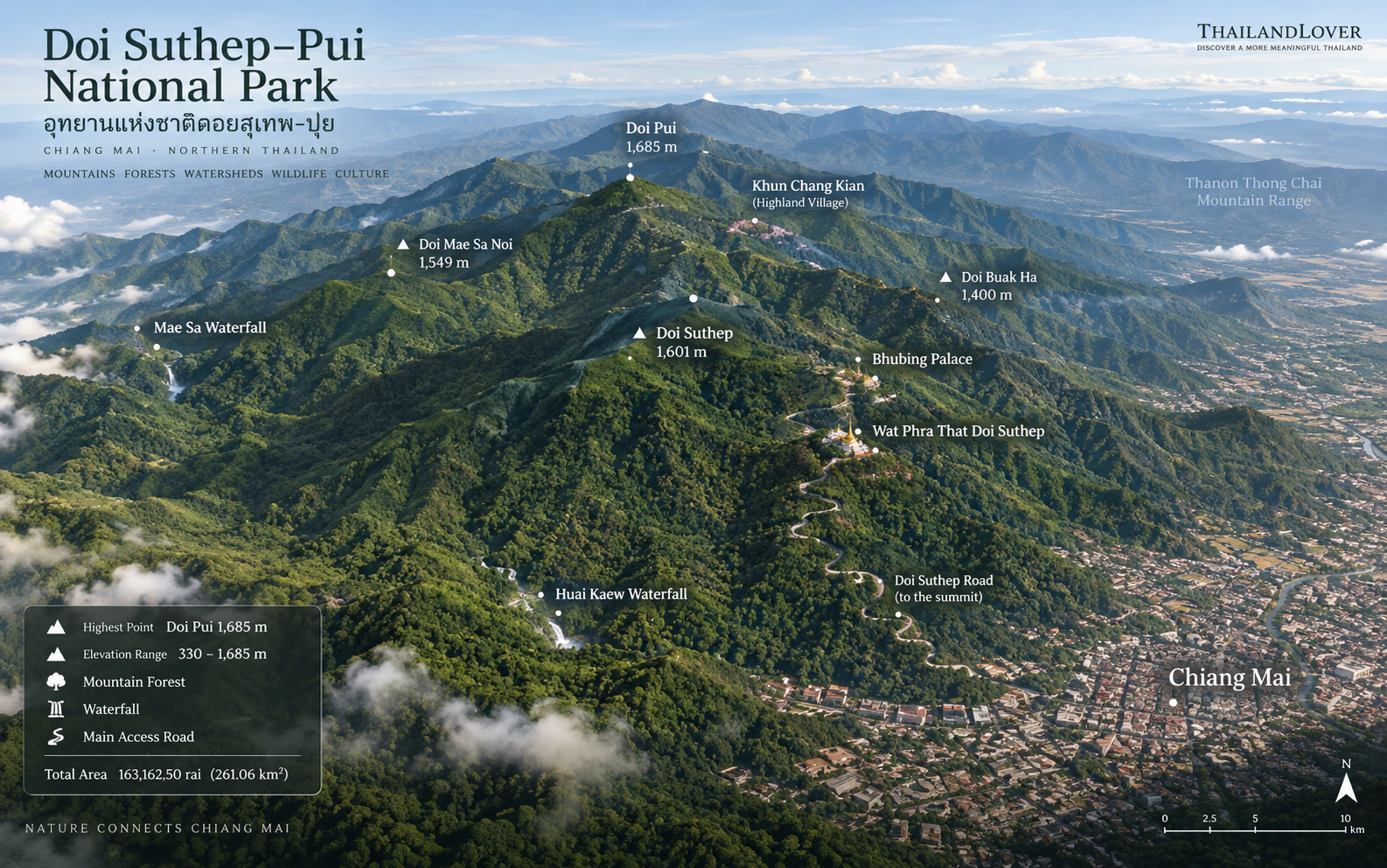
The terrain is mountainous and highly varied, with elevations ranging from approximately 330 metres to 1,685 metres above sea level. The highest point is Doi Pui, at approximately 1,685 metres.
Other significant elevations include:
- Doi Suthep — approximately 1,601 m
- Doi Mae Sa Noi — approximately 1,549 m
- Doi Khom Rong — approximately 1,459 m
- Doi Buak Ha area — approximately 1,400 m
The park’s geology includes granite and other igneous rocks, together with sedimentary and metamorphic formations. This variation in altitude is one of the reasons the park supports several different forest ecosystems.
Chiang Mai’s Watershed
One of Doi Suthep–Pui’s less visible but more important functions is its role as a watershed. Streams originating in the mountain forests feed surrounding communities and eventually contribute to the river systems flowing toward the Ping River.
Important streams and waterways associated with the park include Huai Tueng Tao, Huai Mae Yuak, Huai Kaew, Huai Chang Kian, Huai Pong Noi, Huai Mae Hia, Huai Mae Na Sai and Huai Mae Pon.
The forest is not simply scenery. It is part of the ecological infrastructure supporting Chiang Mai.
A Mountain of Different Forests
Rather than being one uniform forest, Doi Suthep–Pui contains several forest communities that change with elevation.
330–850 metres
1. Dry Dipterocarp Forest
Found mainly around lower and drier areas. Typical trees include dipterocarp species — Teng, Rang, Phluang, Yang, Phayom — and wild mango-related species. This forest becomes particularly characteristic along exposed ridges and slopes.
2. Mixed Deciduous Forest
Occurs across lower and middle elevations. Typical trees include teak, Lagerstroemia, Afzelia, Terminalia, Siamese rough bush and bamboo species. During the dry season, the landscape can change dramatically as deciduous trees lose their leaves.
3. Dry Evergreen Forest
Appears particularly around valleys, streams and areas retaining higher moisture. Important trees include Yang Daeng, Yang Na, Hopea species, wild figs, forest fruit trees, bamboo and understory plants. These areas often create a greener, denser landscape than surrounding deciduous forest.
Above 1,000 metres
4. Hill Evergreen Forest
The environment becomes distinctly cooler and more humid. Visitors may encounter oak species, magnolia-family trees, wild cinnamon, mosses, lichens, ferns, orchids and epiphytes. Trunks and branches can become heavily covered with mosses and lichens.
This is the forest that gives the upper reaches of Doi Suthep–Pui their distinctive northern mountain atmosphere.
Wildlife
Doi Suthep–Pui may be close to a major city, but its forests still support considerable biodiversity.
Birds
More than 350 bird species have been reported in the park. Species lists compiled from different sources should be treated as records rather than guarantees that every species can currently be observed.
Birdwatchers may encounter pheasants, partridges, barbets, bulbuls, flycatchers, woodpeckers, minivets, thrushes, tits, laughingthrushes, sunbirds and raptors. The park’s altitudinal variation makes it particularly interesting for birdwatching.
Mammals
Mammals recorded in the park include wild boar, barking deer (muntjac), macaques, porcupines, civets, squirrels, various rodents and other small and medium-sized mammals. There are also historical and more recent records of rarer mammals in the wider park ecosystem.
Visitors should never assume that a reported species is routinely visible. Wildlife observations are highly seasonal and unpredictable.
Enter the forest as a visitor, not as a wildlife hunter.
Reptiles & Amphibians
The park is particularly interesting for herpetology. Among the species associated with Doi Suthep–Pui is the Doi Suthep bent-toed gecko (Cyrtodactylus doisuthep), associated specifically with this mountain — an important example of specialised biodiversity within the ecosystem.
The park also supports various snakes, lizards, frogs and other amphibians. Mountain streams provide habitat for amphibians that depend on clean, humid forest environments.
The Cultural Landscape
Doi Suthep–Pui is unusual because nature and culture are deeply intertwined. The mountain is not an untouched wilderness in the conventional sense. For centuries, people have lived, travelled, worshipped and cultivated within the wider mountain landscape.
วัดพระธาตุดอยสุเทพ
Wat Phra That Doi Suthep
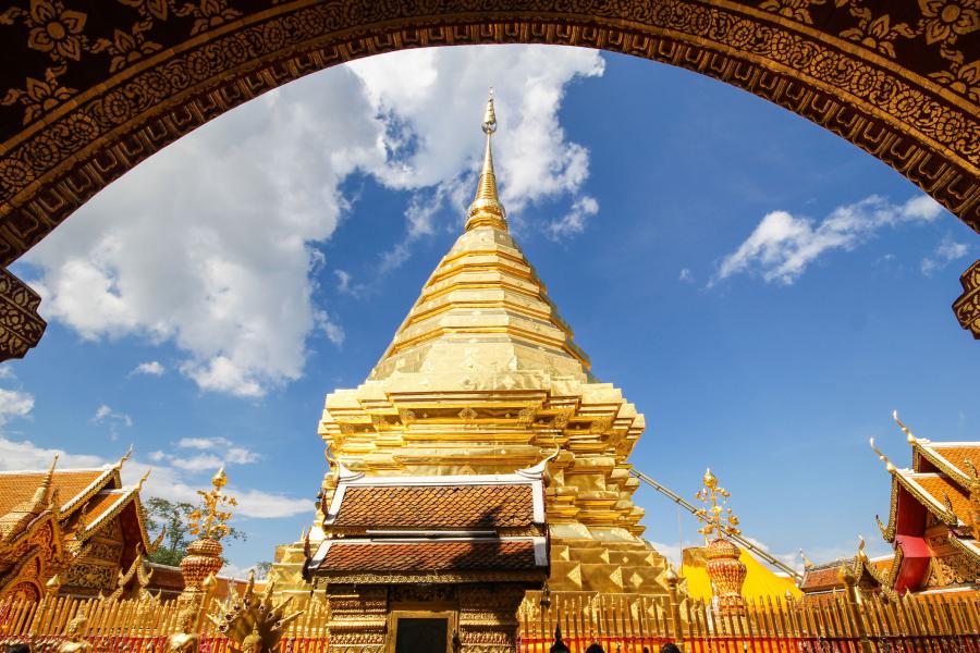
The golden chedi of Wat Phra That Doi Suthep is one of the defining symbols of Chiang Mai. Perched high on Doi Suthep, the temple combines religious significance with one of the city’s most recognisable mountain viewpoints.
For many visitors, this is the first encounter with Doi Suthep–Pui. It should be considered the gateway to the mountain, rather than the entire mountain experience.
Doi Suthep
Local tradition connects the name “Doi Suthep” with the hermit Sudeva / Suthep, associated with the mountain in northern Thai tradition. Older references also associate the mountain with the name Doi Aoy Chang. The mountain later became inseparable from Chiang Mai’s religious identity through Wat Phra That Doi Suthep.
Explore the Mountain
1,685 Metres
Doi Pui
Further along the mountain road, the landscape becomes quieter and more distinctly highland. Doi Pui, at approximately 1,685 metres, is the highest point within the national park. The upper mountain is cooler than Chiang Mai city, especially during the cool season.
This is where Doi Suthep–Pui begins to feel less like a city attraction and more like a genuine mountain destination.
ขุนช่างเคี่ยน
Khun Chang Kian
One of the most atmospheric destinations in the upper landscape is Khun Chang Kian. The area is associated with Hmong highland communities and is particularly well known for Thai cherry blossoms in the winter flowering season. During the right period, the trees can transform the mountain with pink blossom.
The experience is very different from visiting Wat Phra That Doi Suthep. Here the attraction is not a monument. It is the combination of mountain, community, agriculture, cool weather and seasonal flowers.
Doi Pui Nature Trail
The Tourism Authority of Thailand has highlighted the Doi Pui Nature Trail as a “backyard forest” experience for Chiang Mai, with highland vegetation and birdlife. The trail also connects with the wider landscape toward Khun Chang Kian — particularly relevant for travellers who want Doi Suthep–Pui beyond the standard temple visit.
พระตำหนักภูพิงค์ราชนิเวศน์
Bhubing Palace
Bhubing Rajanives Palace occupies the Doi Buak Ha area at approximately 1,400 metres. The complex is known for its gardens, ornamental plants and cooler mountain environment. For visitors interested in gardens and landscape design, it can complement the forest experience particularly well.
Opening arrangements and visitor access should be checked before visiting, because the palace operates under its own visitor rules.
Waterfalls
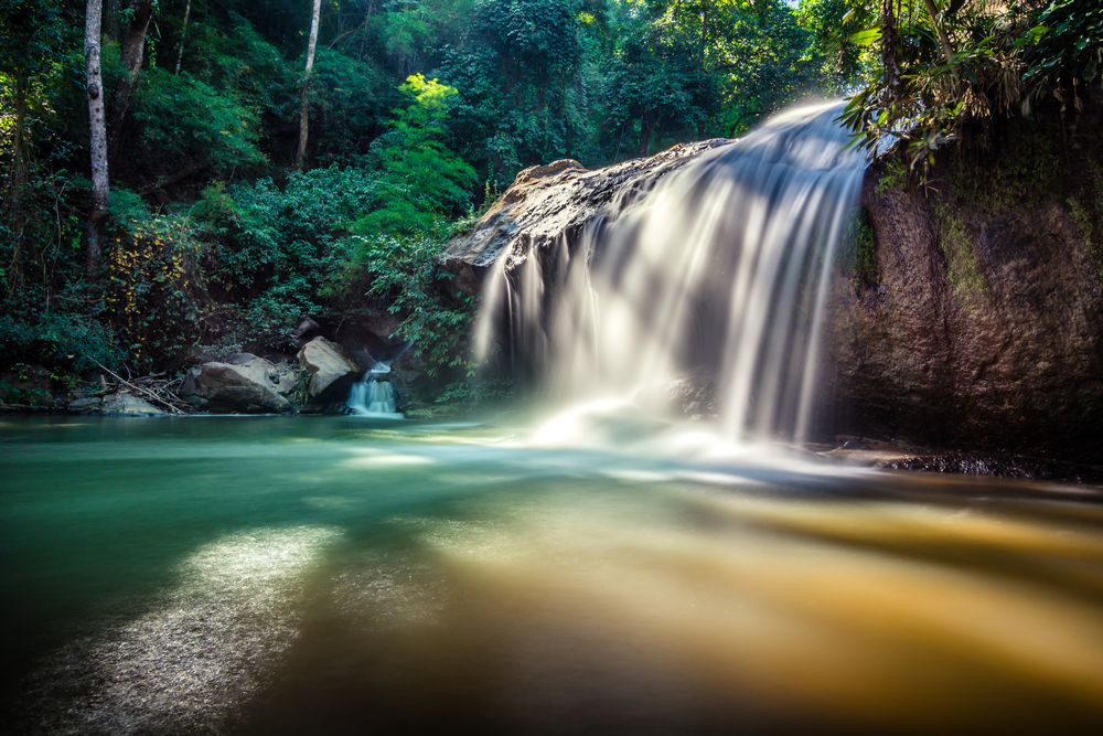
Doi Suthep–Pui contains several waterfalls and mountain streams. Together they demonstrate an important point: the mountain is a watershed first, and a tourist attraction second.
Huai Kaew Waterfall
One of the most accessible waterfalls near Chiang Mai. Its location close to the city makes it an easy introduction to the forest environment of Doi Suthep.
Monthathan Waterfall
Namtok Monthathan is one of the better-known waterfall destinations on Doi Suthep. Surrounded by forest, it offers a more immersive nature experience than simply visiting the mountain’s major cultural attractions.
Mae Sa Waterfall
Located in the wider Doi Suthep–Pui landscape, Mae Sa is a substantial multi-level waterfall system and one of the better-known nature attractions in the Mae Rim area.
Tat Mok Waterfall
Another waterfall within the expanded park area — quieter than the best-known city-side cascades, and part of the same mountain watershed.
What Makes Doi Suthep–Pui Different?
There are many beautiful national parks in Northern Thailand. So why visit this one? Because of its relationship with Chiang Mai.
You can have breakfast in the city. Within a relatively short drive, you can be inside mountain forest, looking across Chiang Mai from above, visiting a centuries-old Buddhist temple, walking through a highland community, photographing seasonal cherry blossoms, listening for mountain birds, exploring waterfalls — or simply sitting beneath a cool forest canopy.
That combination is difficult to reproduce elsewhere.
Best Experiences
- First-time visitors
- Wat Phra That Doi Suthep → Bhubing Palace → Doi Pui. This is the classic mountain route.
- Nature lovers
- Huai Kaew → Monthathan → forest trails. Better for greenery and waterfalls than cultural sightseeing.
- Photography
- Chiang Mai city views, the golden chedi, mountain mist, forest roads, Khun Chang Kian, Thai cherry blossoms, highland villages, morning light, waterfalls, birds and forest detail.
- Birdwatchers
- The combination of elevation, forest types and proximity to Chiang Mai makes this an accessible birdwatching destination — more than 350 species have been reported.
When to Visit Doi Suthep–Pui National Park
- Cool Season · November–February
- Generally the most comfortable period. The upper mountain can become significantly cooler than Chiang Mai city. Cool air, morning mist, winter flowers and Thai cherry blossoms around suitable highland areas. For many visitors, this is the most photogenic season.
- Hot Season · March–April
- Lower elevations can become hot and dry. Higher elevations remain more comfortable than the city, but visibility can vary. Smoke haze can become a significant issue in Northern Thailand during the burning season.
- Green Season · May–October/November
- The forest becomes lush and vibrant. Waterfalls and streams can be more impressive following rainfall. The trade-off is wet trails, slippery rocks, cloud and rain, and reduced visibility on some days. For travellers who value forest atmosphere over clear mountain views, this can be an excellent time.
The Temperature Difference
The city may feel warm while the upper mountain can be distinctly cool. At higher elevations, winter temperatures can occasionally fall to around 5–6°C, particularly during colder periods. If visiting Doi Pui or Khun Chang Kian in the early morning during the cool season, bring a jacket.
How to Get There & How Long to Stay
Doi Suthep–Pui is unusually accessible for a national park. From central Chiang Mai, travel toward the mountain via Huai Kaew Road → Doi Suthep Road, then continue upward toward Wat Phra That Doi Suthep, Bhubing Palace, Doi Pui and Khun Chang Kian.
The lower sections are relatively easy to reach. Upper mountain destinations require more attention to road conditions, weather and vehicle capability.
- 2–3 hours
- Suitable for Wat Phra That Doi Suthep.
- Half day
- Ideal for Doi Suthep + Bhubing Palace + Doi Pui.
- Full day
- Recommended if you want to combine temple, waterfall, forest and highland community.
- 1–2 days
- Best for hiking, birdwatching, photography, camping, slow travel and multiple nature sites.
What to Bring
For a normal day visit: comfortable walking shoes, drinking water, a light jacket, rain protection in the wet season, sun protection, insect repellent, a camera and a small backpack.
For hiking: proper hiking shoes, sufficient water, basic first-aid supplies, a rain shell, an offline map, a headlamp if returning late, and warm clothing during the cool season.
One-Day ThailandLover Route
A full day that moves from the city into the mountain, then higher still. Photographers should shift the itinerary earlier and prioritise morning light and mist.
- 07:00
- Leave Chiang Mai.
- 07:30
- Huai Kaew / lower mountain.
- 08:30
- Wat Phra That Doi Suthep.
- 10:00
- Continue toward upper Doi Suthep.
- 10:30
- Bhubing Palace and the surrounding mountain landscape.
- 12:00
- Lunch.
- 13:00
- Doi Pui.
- 14:00
- Khun Chang Kian.
- 16:00
- Begin descent.
- 17:00
- Return to Chiang Mai.
Doi Suthep–Pui for Different Travellers
- First-time visitor
- Must see: Wat Phra That Doi Suthep.
- Nature lover
- Must see: waterfalls and forest trails.
- Photographer
- Must see: Doi Pui, Khun Chang Kian and morning mist.
- Birdwatcher
- Must see: upper mountain forest.
- Culture traveller
- Must see: Wat Phra That Doi Suthep and highland communities.
- Family
- Best: lower-accessibility attractions and scenic mountain stops.
- Slow traveller
- Best: a full day on the upper mountain rather than rushing back to Chiang Mai.
Responsible Travel
Doi Suthep–Pui is a protected mountain ecosystem next to a major city. That makes responsible behaviour especially important.
- Stay on designated trails
- Carry rubbish out
- Respect wildlife and keep noise low
- Respect local communities, temples and sacred places
- Follow park regulations
- Use established campsites where camping is permitted
- Do not feed wildlife or approach animals
- Do not collect plants, flowers, rocks or animals
- Do not enter restricted areas or light fires outside designated spots
Leave the mountain looking as though you were never there.
Frequently Asked Questions
- What is Doi Suthep–Pui National Park?
- Doi Suthep–Pui National Park is Thailand’s 24th national park, established in 1981. It is the mountain forest landscape rising directly behind Chiang Mai, combining Wat Phra That Doi Suthep, Doi Pui, waterfalls, highland villages and wildlife habitat.
- Where is Doi Suthep–Pui National Park?
- The park is in Chiang Mai Province, covering parts of Mueang Chiang Mai, Mae Rim and Hang Dong. Headquarters are on Huai Kaew Road, Suthep Subdistrict.
- How high is Doi Pui?
- Doi Pui is the highest point in the park at approximately 1,685 metres above sea level. Doi Suthep reaches about 1,601 metres.
- What is Doi Suthep–Pui famous for?
- It is best known for Wat Phra That Doi Suthep, together with Doi Pui, Khun Chang Kian, Bhubing Palace, mountain forests and waterfalls including Huai Kaew, Monthathan and Mae Sa.
- When is the best time to visit Doi Suthep–Pui?
- November to February is generally the most comfortable period, with cooler mountain air, morning mist and Thai cherry blossoms around highland areas such as Khun Chang Kian.
- How do I get to Doi Suthep–Pui from Chiang Mai?
- From central Chiang Mai, travel via Huai Kaew Road onto Doi Suthep Road, then continue up toward Wat Phra That Doi Suthep, Bhubing Palace, Doi Pui and Khun Chang Kian.
- How long should I spend at Doi Suthep–Pui?
- Two to three hours is enough for Wat Phra That Doi Suthep alone. A half day covers the temple, Bhubing Palace and Doi Pui. A full day is better if you want waterfalls, forest and highland communities as well.
- Can I see Thai cherry blossoms at Khun Chang Kian?
- Khun Chang Kian is associated with Thai cherry blossoms during the winter flowering season. Timing varies by year, so check current bloom conditions before travelling.
Explore More of Chiang Mai & the North
- Doi Inthanon National Park
- Thailand’s highest peak — a longer mountain day when you want to go beyond Chiang Mai’s backyard forest.
- Op Luang National Park
- A dramatic river gorge south of Chiang Mai for travellers continuing into the highlands.
- Si Lanna National Park
- Lakes, forest and cooler northern landscapes north of the city.
- Huai Nam Dang National Park
- Sea of mist and mountain ridges on the Chiang Mai–Mae Hong Son route.
- Doi Pha Hom Pok National Park
- One of the north’s high peaks, for travellers heading toward Fang.
- Doi Khun Tan National Park
- A forest mountain between Chiang Mai and Lampang, reached by the historic railway.
- Nature & Parks
- More mountains, forests and protected landscapes across ThailandLover’s collection.
Location
Find Doi Suthep–Pui National Park
Huai Kaew Road, Suthep, Chiang Mai, Northern Thailand