


National Park · Lamphun & Lampang
Where the Railway Enters the Forest: Doi Khun Tan National Park
อุทยานแห่งชาติดอยขุนตาล
Lamphun · Lampang · Northern Thailand
Small Trails. Big Stories.
Railway, forest, hiking, history and slow travel intersect on the Khun Tan Range — a mountain journey that begins where the Northern Railway meets the trees.
Basic Information
- Name
- Doi Khun Tan National Park
- Thai Name
- อุทยานแห่งชาติดอยขุนตาล
- Province
- Lamphun & Lampang, Northern Thailand
- Districts
- Mae Tha (Lamphun) · Hang Chat & Mueang Lampang (Lampang)
- Established
- 5 March 1975
- National Park
- Thailand’s 10th National Park
- Area
- Approximately 255.29 km² (159,556.25 rai)
- Highest Point
- Y.4 / Doi Khun Tan Peak — approximately 1,373 metres above sea level
- Mountain Range
- Khun Tan Range
- Landscape
- Mountain forest · Evergreen forest · Pine forest · Ridgelines · Streams · Waterfalls · Highland valleys
- Signature Experience
- The Y.1–Y.4 hiking route
- Signature Landmark
- Khun Tan Railway Tunnel
- Signature Gateway
- Khun Tan Railway Station
- Signature Waterfall
- Tad Moei Waterfall
- Best Known For
- Railway history · Mountain hiking · Pine forest · Strategic viewpoints · Slow travel
- Management
- Department of National Parks, Wildlife and Plant Conservation (DNP)
Doi Khun Tan covers approximately 255.29 km² (159,556.25 rai) across Lamphun and Lampang and was established on 5 March 1975 as Thailand’s 10th national park — a standout destination in ThailandLover’s Nature & Parks collection.
A Mountain You Reach on Foot
Where the Train Stops and the Trail Begins
Some mountains are introduced by road.
Doi Khun Tan is introduced by rail.
Between Lamphun and Lampang, the Northern Railway cuts into the Khun Tan Range. At Khun Tan Railway Station, the landscape changes: steel and sleepers give way to pine, evergreen forest, ridgelines and a sequence of walking points known as Y.1 to Y.4.
Train → tunnel → forest → Y.1 → Y.2 → Y.3 → Y.4 → summit.
That sequence is the heart of the place.
This is not a destination designed for checklist tourism. It rewards travellers who like to arrive slowly, walk steadily and let a mountain reveal itself in stages.
Small trails.
Big stories.
A railway that enters the forest — and a forest that still remembers why the mountain mattered.

Why Doi Khun Tan Is Different
Not Another Doi Inthanon
Doi Inthanon National Park is altitude, cloud forest and large-scale highland biodiversity.
Doi Khun Tan is something else.
Here the story is railway and forest, hiking and history, pine shade and strategic ridgelines. The mountain is lower, quieter and more intimate. Its drama comes from movement through place: arriving by train, reading the tunnel as engineering history, then climbing through named points that still carry the memory of strategy and observation.
If Doi Inthanon asks you to understand a high ecosystem,
Doi Khun Tan asks you to understand a journey.
The Khun Tan Range
A Ridge Between Two Provinces
The park protects a stretch of the Khun Tan Range where Lamphun and Lampang meet.
Mountain forest, evergreen cover, pine stands, streams and highland valleys shape a landscape that feels both connected and apart — close enough to Chiang Mai’s wider travel circuit to reach, yet different enough to feel like its own northern chapter.
The range also helps explain the railway. Building a northern line through this topography required one of Thailand’s most significant early railway engineering works: the Khun Tan Tunnel.
The Y.1–Y.4 Trail
Four Points. One Mountain Narrative.
The principal hiking sequence of Doi Khun Tan is Y.1 → Y.2 → Y.3 → Y.4.
The “Y.” refers to historical strategic points associated with the Thai term ยุทธศาสตร์.
- Y.1
- Approximately 900 m — railway gateway
- Y.2
- Approximately 1,035 m — pine forest and camping character
- Y.3
- Approximately 1,225 m — deeper mountain / historic accommodation zone
- Y.4
- Approximately 1,373 m — summit / Doi Khun Tan Peak
Tourism materials have often described a broader mountain circuit that connects tunnel, station, the Y points and Tad Moei Waterfall. Treat published routes as orientation, not guaranteed trail distances — and always confirm current access with the park.
This is not a scramble for spectacle.
It is a measured ascent through named chapters of the same mountain.
Y.1 — The Railway Gateway
~900 Metres
Y.1 is where the railway story and the walking story meet.
Around 900 metres, it functions as the gateway into the climbing sequence. The character here is transitional: still close to the railway landscape, already entering forest and mountain air.
For many travellers, Y.1 is the first moment when Doi Khun Tan stops being a station stop and becomes a trail.
Y.2 — Pine Forest and Highland History
~1,035 Metres
Y.2 is associated with pine forest and camping.
At around 1,035 metres, the mountain’s atmosphere often feels cooler and more open under pine canopy. This is one of the strongest places to understand why overnight stays matter at Doi Khun Tan: the forest changes after dark, and morning light through pines is part of the experience.
Camping here is less about luxury and more about remaining inside the mountain’s rhythm.
Y.3 — Deeper into the Mountain
~1,225 Metres
Y.3 sits deeper in the ascent at about 1,225 metres.
Historically, this zone is associated with missionary residence and accommodation later connected with Payap University management. That layer matters. Doi Khun Tan is not only ecology and engineering; it is also a mountain that has long hosted people who stayed, taught, rested and watched the ranges.
By Y.3, the railway feels farther behind. The forest becomes the main language of the walk.
Y.4 — The Summit of Doi Khun Tan
~1,373 Metres
Y.4 is Doi Khun Tan Peak — approximately 1,373 metres above sea level.
Historically it was associated with a strategic observation position. Today it is the summit conclusion of the Y.1–Y.4 journey.
It is not Thailand’s highest mountain, and it does not need to be. Its value is narrative: you have climbed from railway gateway through pine and deeper forest to a named high point on the Khun Tan Range.
The summit is earned by sequence, not by altitude ranking.
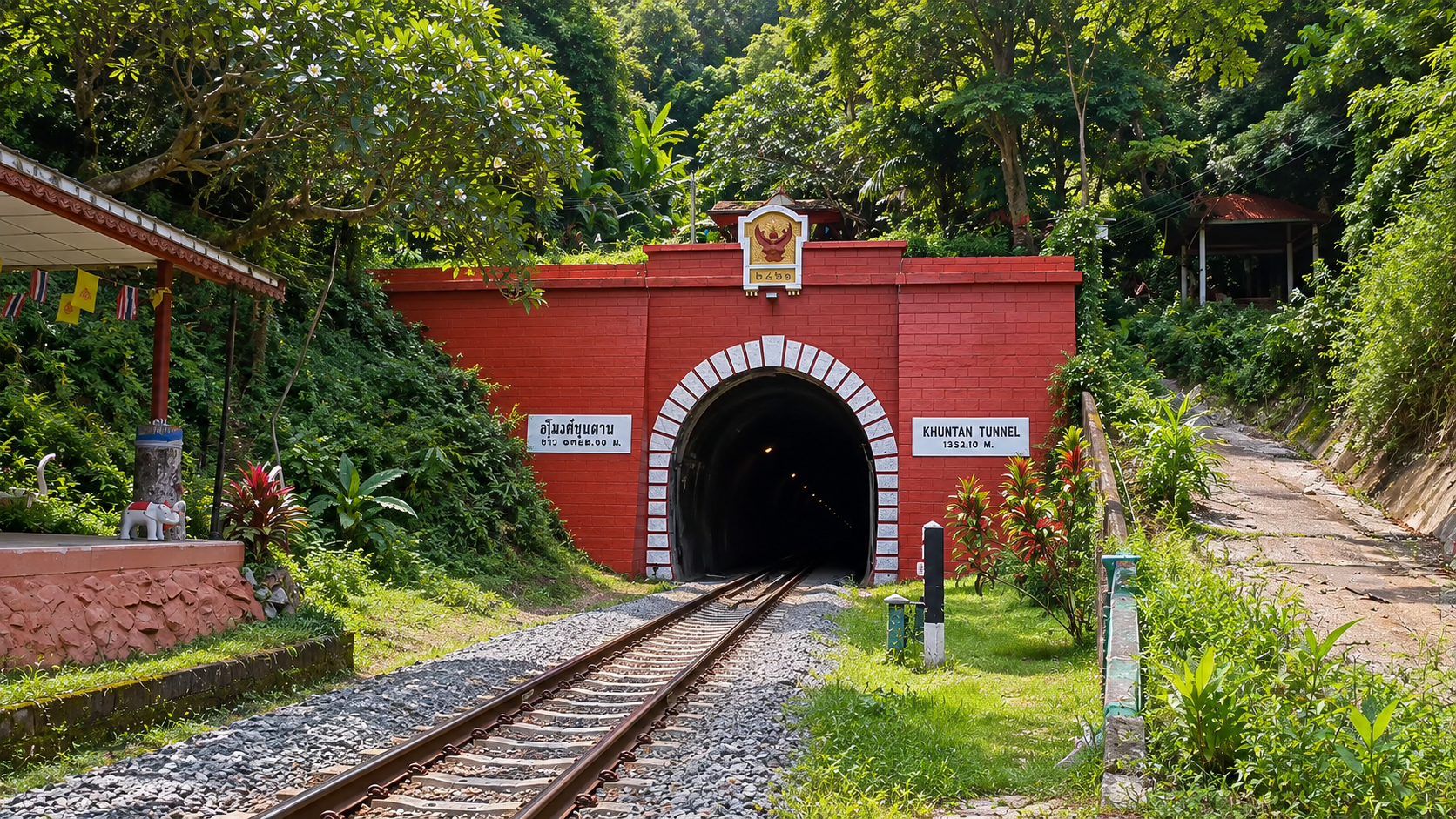
Khun Tan Railway Tunnel
~1,352 Metres of Northern Railway History
Khun Tan Railway Tunnel is the park’s signature landmark — approximately 1,352 metres long, often marked as about 1,352.10 m.
Construction began in 1907 and was completed in 1918. The tunnel remains part of an active railway.
Seen correctly, the tunnel is not an adventure playground. It is living infrastructure and one of the clearest physical reminders of how northern Thailand was linked by rail through difficult mountain terrain.
The Engineering Story
Emil Eisenhofer and the Northern Line
The tunnel’s construction history is closely associated with engineer Emil Eisenhofer and the wider development of the Northern Railway.
That story sits beside the forest, not apart from it. At Doi Khun Tan, nature and infrastructure share the same mountain. Understanding the engineering does not diminish the park; it explains why the railway gateway feels so inseparable from the hiking landscape.
Khun Tan Railway Station
The Mountain’s Signature Gateway
Khun Tan Railway Station is one of the most distinctive national-park gateways in Thailand.
According to Lamphun tourism information, the station sits at approximately 578 metres above sea level. From here, the forest is close, the tunnel is part of the landscape’s identity, and the walk toward Y.1 begins to make sense.
Few northern parks begin with such a clear threshold:
arrive by train, then continue on foot.
Tad Moei Waterfall
Where the Mountain Turns Water into Sound
Tad Moei Waterfall is one of the park’s important waterfall attractions and a natural counterpoint to the railway-and-ridge narrative.
After tunnels, stations and strategic points, water restores a quieter reading of the mountain: forest moisture, stream sound, cooler air and the reminder that Doi Khun Tan is also a watershed landscape.
Flow and access change with rainfall and season. Confirm current conditions before including Tad Moei in a one-day or overnight plan.
The Forests of Doi Khun Tan
Evergreen Cover, Ridges and Shade
The protected landscape includes mountain forest and evergreen forest alongside pine stands, streams and highland valleys.
That mix is why the walk feels varied even without extreme altitude. Shade, ridge light, understorey texture and changing canopy become the main visual language of the day.
Nearby northern parks such as Chae Son offer different mountain signatures; Doi Khun Tan’s identity remains railway-linked forest walking.
Pine Forest
The Atmosphere Around Y.2
Pine forest is one of the park’s most memorable ecological characters, especially around the Y.2 zone.
Needles underfoot, cooler air, filtered light and camping culture give this section a distinct northern mood. For photography and overnight stays, pine forest often becomes the emotional centre of a Doi Khun Tan trip.
Plants and Botanical Diversity
Look Closely as You Climb
Elevation changes across Y.1–Y.4 create a botanical journey even within a relatively compact mountain.
Evergreen forest, pine stands, understorey plants, ferns and seasonal flowering all reward slow observation. Do not expect a botanical garden display. Expect a living mountain forest that reveals more when you stop talking and keep walking.
Wildlife
Evidence of a Living Forest
Doi Khun Tan supports wildlife associated with northern mountain forest environments.
Sightings are never guaranteed. The better approach is to look for evidence of a living landscape: tracks, calls, movement at forest edges, and the quiet density of habitat rather than a safari expectation.
Come for the journey.
Let wildlife remain a possibility, not a promise.
Birdwatching
Early Light Along the Ridge
Birdwatching at Doi Khun Tan is best treated as a quiet overlay on the hike rather than a separate product.
Early mornings around forest edges, pine zones and ridgelines offer the strongest chance of rewarding encounters. Bring patience and binoculars if you care about birds; leave speakers and rush behind.
The Watershed
Ping and Wang River Basins
Beyond scenery, the mountain functions as a watershed landscape.
The wider Khun Tan mountain system contributes to drainage associated with the Ping and Wang river basins. Streams, forest cover and highland valleys are not decoration; they are part of how northern Thailand holds and moves water.
To walk Doi Khun Tan carefully is also to walk a working watershed.
Doi Khun Tan and the Railway
Infrastructure Inside a Protected Mountain
Few Thai national parks are so clearly defined by railway geography.
Station, tunnel, forest edge and trail form a single narrative. That is why the best visits treat the railway as context and gateway — never as an informal walking route. Respect active rail operations, then let the mountain take over on marked paths.
A Place of Strategic History
Why the “Y.” Points Still Matter
The Y points are not modern marketing labels. They refer to historical strategic points — ยุทธศาสตร์ — and Y.4 in particular was associated with observation.
That history sits lightly on the landscape today, but it deepens the walk. You are not only climbing for view. You are moving through a mountain once read for position, range and connection across northern terrain.
For wider cultural context, see ThailandLover’s guide to Thai Culture & Traditions.
Doi Khun Tan as Slow Travel
Small Trails. Big Stories.
This is a park for travellers who prefer sequence over spectacle.
Arrive by train if you can. Walk a realistic section of Y.1–Y.4. Stay overnight if conditions allow. Listen to pine forest after dark. Leave the tunnel alone. Let the mountain remain a story rather than a checklist.
Compared with larger circuits and louder destinations, Doi Khun Tan belongs to the quieter side of ThailandLover’s northern map — alongside places such as Chaloem Rattanakosin and Chaloem Phrakiat Thai Prachan, where landscape rewards attention more than speed.
One-Day Experience
A First Reading of the Mountain
A strong one-day visit might combine:
Station / tunnel viewpoint (safe public areas only) → Y.1 → Y.2 → optional push toward Y.3 → return before dark.
If time and conditions allow, Tad Moei can be considered as a separate nature stop rather than a forced add-on. Do not invent a full summit-or-nothing day if fitness, weather or daylight are against you.
Two-Day Experience
The Better Way to Understand Doi Khun Tan
Day 1 — Arrive and Enter the Forest
Train or road arrival → Khun Tan Railway Station area → safe tunnel viewing → walk into Y.1 and Y.2 → pine-forest overnight if camping is available.
Day 2 — Deeper Mountain and Descent
Continue toward Y.3 and Y.4 if conditions and fitness allow → optional Tad Moei depending on access → descend and return.
Two days turn Doi Khun Tan from a stop into a journey.
Camping
Stay Where the Pines Hold the Night
Camping has long been part of the Doi Khun Tan experience, particularly in association with the pine-forest character around Y.2.
Facilities, permissions and overnight availability can change with season, weather, fire risk and park operations. Confirm current camping rules with Doi Khun Tan National Park before travel.
Weather
Cooler Air, Changing Mountain Conditions
Weather shifts with elevation and season. Higher points feel cooler than the station zone. Rain can make trails slippery. Dry-season haze can mute views and affect comfort.
Pack layers, water and rain protection even for a short visit. Mountain forecasts are guidance, not guarantees.
The Fire Season
Dry Season, Smoke and Park Announcements
Northern Thailand’s dry season can bring wildfire, smoke and haze. Doi Khun Tan experienced wildfire-control operations in 2026.
Do not treat March–April as automatically ideal. Before travelling in the dry season, check:
- Air Quality
- Current AQI and personal comfort thresholds.
- Wildfire & Smoke
- Regional burning conditions and visibility.
- Park Announcements
- Trail status, camping rules and temporary restrictions.
Best Time to Visit
- Cool Season
- Generally the most comfortable period for hiking, overnight stays and clearer mountain air.
- Rainy Season
- Greener forest and stronger waterfalls, with wetter trails and possible temporary closures.
- Dry / Hot Season
- Can be affected by haze, smoke and wildfire risk — check AQI and park announcements; do not assume ideal conditions.
For broader timing across Thailand, see When to Go.
Opening and Current Access
Published visitor information commonly lists general operating hours around 08:00–18:00.
Tourism information in 2026 indicated that tourism and overnight stays resumed from 1 May 2026. Treat that as published information for that period, not as a permanent guarantee of year-round overnight access.
Hours, trail access, camping and temporary closures can change. Current conditions should be confirmed with Doi Khun Tan National Park before travel.
Entrance Fees
Published current visitor information has listed:
- Thai Visitors
- Adult 20 THB · Child 10 THB
- Foreign Visitors
- Adult 100 THB · Child 50 THB
Fees are changeable and may be updated, waived on special occasions or applied differently by policy. Verify current entrance fees before travel. Do not treat published rates as permanent guarantees.
How to Get There
By Train
The Signature Arrival
Travelling by Northern Railway to Khun Tan Railway Station is the most characteristic way to begin a Doi Khun Tan visit.
Check current schedules, ticket availability and station access before departure. From the station, continue into the park on marked paths. Never use tracks or the tunnel as a walking route.
By Car
Flexible Access from Lamphun & Lampang
Road approaches via Lamphun and Lampang give flexibility for day trips, gear transport and waterfall plans. Driving is practical, but it removes part of the railway narrative that makes this park distinctive.
From Chiang Mai, treat Doi Khun Tan as a regional northern destination rather than a city-edge outing. Exact times depend on route, traffic and where you enter the park.
The Train Journey
Arrival as Part of the Landscape
The train is not merely transport. It is the first chapter.
Watching the line enter mountain terrain, stepping onto Khun Tan platform and seeing forest close at hand creates an arrival few other Thai parks can match. Keep that romance grounded in safety: admire the tunnel from public areas, then walk the mountain on trails.
Photography
Mist, Pine Light and Railway Geometry
Strong frames at Doi Khun Tan often come from contrast: red tunnel architecture against forest, pine canopy light, ridge mist and the quiet geometry of station and mountain.
Sunrise and sea-of-mist views are never guaranteed. Photograph what the day actually gives you, and stay clear of restricted railway zones while doing it.
Responsible Travel
Railway Safety + Leave No Trace
- Railway Safety
- No tunnel entry, no track walking, no standing on tracks, no obstructing trains. Use safe public viewing areas only.
- Stay on Marked Trails
- Protect forest understorey and your own safety.
- Leave No Trace
- Carry out rubbish, keep noise low and respect overnight rules.
- Fire Awareness
- Follow park guidance during dry-season fire risk.
Who Is Doi Khun Tan For?
Especially Suitable for
- Slow Travellers
- Who value arrival, walking and overnight forest time.
- Railway Enthusiasts
- Interested in Northern Railway history and mountain engineering — from safe public areas.
- Hikers
- Looking for a clear Y.1–Y.4 narrative rather than a single viewpoint stop.
- Campers
- Drawn to pine forest and quieter overnight mountain stays.
- Photographers
- Who prefer mist, pine light and railway-forest contrast over guaranteed panoramas.
Less Suitable for
- Rush Visitors
- Expecting one dramatic summit spectacle in an hour.
- Track Explorers
- Anyone tempted to enter tunnels or walk active railway lines.
- Highest-Mountain Seekers
- Looking for Thailand’s highest peak — that is Doi Inthanon, not Doi Khun Tan.
- Haze-Sensitive Travellers in Peak Burning Periods
- Without checking AQI and park conditions first.
Doi Khun Tan vs Doi Inthanon
- Doi Inthanon
- Altitude · Cloud forest · Large-scale biodiversity · Thailand’s highest mountain at 2,565 m
- Doi Khun Tan
- Railway · Forest · History · Hiking journey · Summit around 1,373 m at Y.4
Visit Doi Inthanon for a vertical ecological world. Visit Doi Luang National Park for a three-province mountain landscape of trekking and waterfalls. Visit Doi Khun Tan for a railway-to-ridge story that rewards slower walking and overnight attention.
Frequently Asked Questions
- What is Doi Khun Tan National Park famous for?
- Doi Khun Tan National Park is known for the meeting of railway history and mountain hiking between Lamphun and Lampang. Travellers come for the Y.1–Y.4 trail, pine forest, Tad Moei Waterfall, Khun Tan Railway Station and the historic Khun Tan Railway Tunnel. It is a quieter northern landscape built around walking, forest atmosphere and a memorable approach by train.
- Where is Doi Khun Tan National Park?
- The park sits on the Khun Tan Range between Lamphun and Lampang in Northern Thailand. It covers Mae Tha District in Lamphun, and Hang Chat and Mueang Lampang districts in Lampang. The protected area is approximately 255.29 km². Khun Tan Railway Station is one of the most distinctive gateways into the mountain.
- How high is Doi Khun Tan?
- The highest point is Y.4 / Doi Khun Tan Peak at approximately 1,373 metres above sea level. The classic ascent rises through Y.1 around 900 m, Y.2 around 1,035 m and Y.3 around 1,225 m before reaching the summit. It is a meaningful highland walk, not Thailand’s highest mountain.
- What is Y.1–Y.4 at Doi Khun Tan?
- Y.1–Y.4 is the park’s principal hiking sequence through the mountain. The points rise from the railway gateway at Y.1 through pine forest at Y.2 and deeper forest at Y.3 to the summit at Y.4. The “Y.” refers to historical strategic points linked to the Thai term ยุทธศาสตร์. Together they form a clear walking narrative from station to summit.
- What does Y.4 mean at Doi Khun Tan?
- Y.4 marks the summit of Doi Khun Tan at about 1,373 metres. Historically it was associated with a strategic observation position overlooking the surrounding ranges. For visitors today it is the high point of the Y.1–Y.4 journey — a place where forest, ridge and mountain air reward a patient climb rather than a rushed viewpoint stop.
- How difficult is the Doi Khun Tan hiking trail?
- The Y.1–Y.4 route is a sustained mountain walk with steady elevation gain rather than a technical climb. Fitness helps, especially if you continue to Y.4 or carry overnight gear. Surfaces and conditions change with weather and season. Walk steadily, wear proper shoes, carry water and confirm current trail status with the park before you go.
- Can you visit Doi Khun Tan by train?
- Yes. Arriving by train at Khun Tan Railway Station is one of the park’s signature experiences. The station sits near the forest edge and makes the mountain feel reachable on foot from the railway itself. Check current Northern Railway schedules and station access before travel, then continue into the park on marked paths rather than railway infrastructure.
- Where is Khun Tan Railway Station?
- Khun Tan Railway Station is the historic mountain gateway associated with Doi Khun Tan National Park on the Northern Railway between Lamphun and Lampang. Lamphun tourism information places the station at about 578 metres above sea level. From here, the walking journey toward Y.1 and the forest begins.
- How long is Khun Tan Railway Tunnel?
- Khun Tan Railway Tunnel is approximately 1,352 metres long — often marked as about 1,352.10 m. Construction began in 1907 and was completed in 1918 as part of Northern Railway development. It remains an active railway tunnel and should be admired from safe public viewing areas only.
- Can visitors enter Khun Tan Railway Tunnel?
- No. The tunnel is part of an active railway route. Visitors must not enter the tunnel, walk on tracks, stand on tracks or enter restricted railway areas. Photograph and observe only from safe public spaces. The hiking story of Doi Khun Tan belongs on marked trails, not on railway infrastructure.
- What is Tad Moei Waterfall?
- Tad Moei Waterfall is one of the park’s important waterfall destinations and a natural counterpart to the railway-and-ridge story of Doi Khun Tan. It offers forest water, cooler air and a quieter sense of the mountain’s watershed. Access and flow change with season and rainfall, so check current conditions before including it in your route.
- Can I camp at Doi Khun Tan?
- Yes, camping has long been part of the Doi Khun Tan experience, especially around the pine-forest character associated with Y.2. Accommodation and campsite availability can change with season, weather and park operations. Confirm current camping rules, overnight permissions and facilities with Doi Khun Tan National Park before travel.
- When is the best time to visit Doi Khun Tan?
- Cool-season months generally offer the most comfortable hiking weather and clearer mountain air. The rainy season brings greener forest and stronger waterfalls but wetter trails. Dry-season haze and wildfire risk can affect travel, so March–April should never be assumed ideal. Always check AQI, smoke and park announcements before you go.
- Is Doi Khun Tan open during the rainy season?
- The park can be visited in the rainy season, when forest cover is lush and waterfalls gain strength. Trails may be slippery, and temporary closures can occur for safety. Published visitor hours and access can change, so confirm current trail status, overnight rules and weather conditions with the park before travelling.
- Is Doi Khun Tan affected by northern Thailand's burning season?
- Yes. Like much of northern Thailand, Doi Khun Tan can be affected by dry-season wildfire, smoke and haze. Wildfire-control operations were reported in 2026. Travellers should check air quality, smoke conditions, trail status and park announcements before visiting during the dry season rather than relying on older itineraries.
- How much is the entrance fee to Doi Khun Tan National Park?
- Published visitor information has listed Thai rates around 20 THB for adults and 10 THB for children, and foreign rates around 100 THB for adults and 50 THB for children. Fees are changeable and may differ by holiday or policy update. Verify current entrance fees with Doi Khun Tan National Park before travel.
- How do I get from Chiang Mai to Doi Khun Tan?
- Many visitors combine a Northern Railway journey to Khun Tan Railway Station with onward walking into the park, or drive via Lamphun and Lampang approaches. Exact travel time depends on train schedules, road conditions and where you enter. Treat Chiang Mai as a practical regional base, not as if the park sits on the city edge.
- Is Doi Khun Tan suitable for beginners?
- Beginners can enjoy parts of the landscape, especially if they keep the day short, walk steadily and do not force a full summit push. The Y.1–Y.4 sequence becomes more demanding with elevation and distance. Choose a realistic section, bring water and proper shoes, and confirm conditions with the park before setting out.
Quick Facts
- Official Name
- Doi Khun Tan National Park
- Thai
- อุทยานแห่งชาติดอยขุนตาล
- Provinces
- Lamphun · Lampang
- Districts
- Mae Tha · Hang Chat · Mueang Lampang
- Established
- 5 March 1975
- National Park No.
- 10th
- Area
- Approximately 255.29 km² / 159,556.25 rai
- Highest Point
- Y.4 / Doi Khun Tan Peak ~1,373 m
- Mountain Range
- Khun Tan Range
- Signature Trail
- Y.1–Y.4
- Signature Landmark
- Khun Tan Railway Tunnel (~1,352 m)
- Signature Gateway
- Khun Tan Railway Station (~578 m)
- Signature Waterfall
- Tad Moei Waterfall
- Signature Forest
- Pine forest and evergreen mountain forest
- Watershed
- Associated with Ping and Wang river basins
- Theme
- Small Trails. Big Stories.
- Published Hours
- Around 08:00–18:00 (confirm current)
- Thai Entrance Fee
- 20 THB adult / 10 THB child (changeable)
- Foreign Entrance Fee
- 100 THB adult / 50 THB child (changeable)
Location
Find Doi Khun Tan National Park
Mae Tha, Lamphun / Hang Chat & Mueang Lampang, Northern Thailand