


National Park · Chiang Rai
Khun Chae National Park
อุทยานแห่งชาติขุนแจ
Where the Forest Climbs Into the Clouds
Wiang Pa Pao, Chiang Rai · Northern Thailand
A high mountain sanctuary where ancient forest, waterfalls and cloud-covered ridges rise toward Doi Langka — one of Northern Thailand’s great high-altitude wilderness landscapes.
ขุนแจ — The High Mountains of Chiang Rai
Deep in the mountains of Chiang Rai, Khun Chae rises from forested valleys to Doi Langka at 2,031 metres — a world of waterfalls, pine forests, misty ridges and long mountain trails.
Khun Chae National Park protects approximately 270 km² of rugged mountain landscape in Wiang Pa Pao District. Established in 1995, the park lies within the Khun Tan Range. Its landscape changes dramatically with elevation, from bamboo and deciduous forest to evergreen, pine and montane forest, while waterfalls such as Khun Chae and Mae Tho carry mountain water through the protected landscape.
Climb higher. Walk deeper. Find the North beyond the road.
Khun Chae at a Glance
- Official Name
- Khun Chae National Park
- Thai Name
- อุทยานแห่งชาติขุนแจ
- Province
- Chiang Rai
- District
- Wiang Pa Pao
- Main Subdistrict
- Mae Chedi Mai
- Established
- 14 August 1995
- National Park Number
- 80th national park of Thailand
- Legal Area
- 168,750 rai / 270 km²
- Mountain Range
- Khun Tan Range
- Highest Summit
- Doi Mae Tho / Doi Langka Luang — 2,031 m
- Other Major Peak
- Doi Mot — approximately 1,700 m
- Major Landscape
- High mountains, deep valleys, evergreen forest, pine forest and deciduous forest
- Major Waterfalls
- Khun Chae Waterfall, Mae Tho Waterfall
- Major Reservoir
- Mae Chang Khao Reservoir
- Major Trek
- Doi Langka Luang — approximately 4 days / 3 nights
- Other Trekking Areas
- Doi Mot, Doi Pha Ngom, Doi Sanka
- Main Highway
- Route 118, Chiang Mai–Chiang Rai
- Best General Season
- November–March
- Main Character
- High-altitude northern mountain wilderness
The park was formally established by Royal Decree published in the Royal Gazette on 14 August 1995, covering approximately 270 km². Current Department of National Parks information continues to list Khun Chae as a national park.
The Mountain Beyond the Road
Most travellers driving between Chiang Mai and Chiang Rai know Highway 118. They know the winding mountain road. They know Mae Khachan. They know the hot springs. They know the changing landscape between the two provinces.
Somewhere along this journey, another landscape rises quietly behind the road. A much wilder one.
This is Khun Chae — a mountain landscape where the road is only the entrance. Beyond it are deep valleys, evergreen forests, pine ridges, waterfalls, clouds, and finally Doi Langka, rising to approximately 2,031 metres above sea level.
Beyond the road, the mountain begins.
The Name, and the Birth of the Park
Khun Chae National Park takes its name from Khun Chae Waterfall. The waterfall became the identifying feature of the protected landscape, and when the area was formally established as a national park in 1995, the park adopted the name Khun Chae.
It is an important distinction. The park is not named after its highest mountain. It is named after one of its waterfalls — a high-mountain park named after water.
The story began before the official designation. In 1989, the Royal Forest Department began surveying the forests around Khun Chae Waterfall and neighbouring forest areas. In 1992, the Cabinet approved the establishment proposal. Then, on 14 August 1995, the Royal Decree officially established Khun Chae National Park.
The protected area covered approximately 168,750 rai — 270 km² — including forest areas of Mae Poon Noi, Mae Poon Luang and Huai Pong Men. Khun Chae belongs to the generation of Thai national parks established during the major expansion of northern protected areas in the 1990s.
Where Is Khun Chae?
Khun Chae National Park is in Wiang Pa Pao District, Chiang Rai Province. The park lies approximately between the Chiang Mai and Chiang Rai landscapes and is crossed by Highway 118, the principal Chiang Mai–Chiang Rai route. Park headquarters is in Mae Chedi Mai Subdistrict.
It sits within the Khun Tan Range — the highlands separating the intermontane basins of Chiang Mai and Chiang Rai. The highest point of the range is Doi Mae Tho, also known as Doi Langka Luang / Doi Lang Ka, at approximately 2,031 metres. The summit lies close to the meeting zone of Chiang Rai, Chiang Mai and Lampang landscapes.

Doi Langka — The Roof of Khun Chae
Doi Langka is the mountain that gives Khun Chae its greatest altitude. Its summit rises to approximately 2,031 metres. It is also known as Doi Langka, Doi Langka Luang and Doi Mae Tho. The different names can cause confusion in travel information, but they refer to the same high mountain landscape.
At approximately 2,031 metres, Doi Langka is among Thailand’s highest mountain summits. It is commonly described as the country’s fifth-highest mountain, depending on the ranking system and whether individual summits or mountain groups are counted. For accuracy, ThailandLover emphasises the more defensible fact: Doi Langka rises to approximately 2,031 metres and is the highest summit of the Khun Tan Range. That is the geographical fact that matters most.
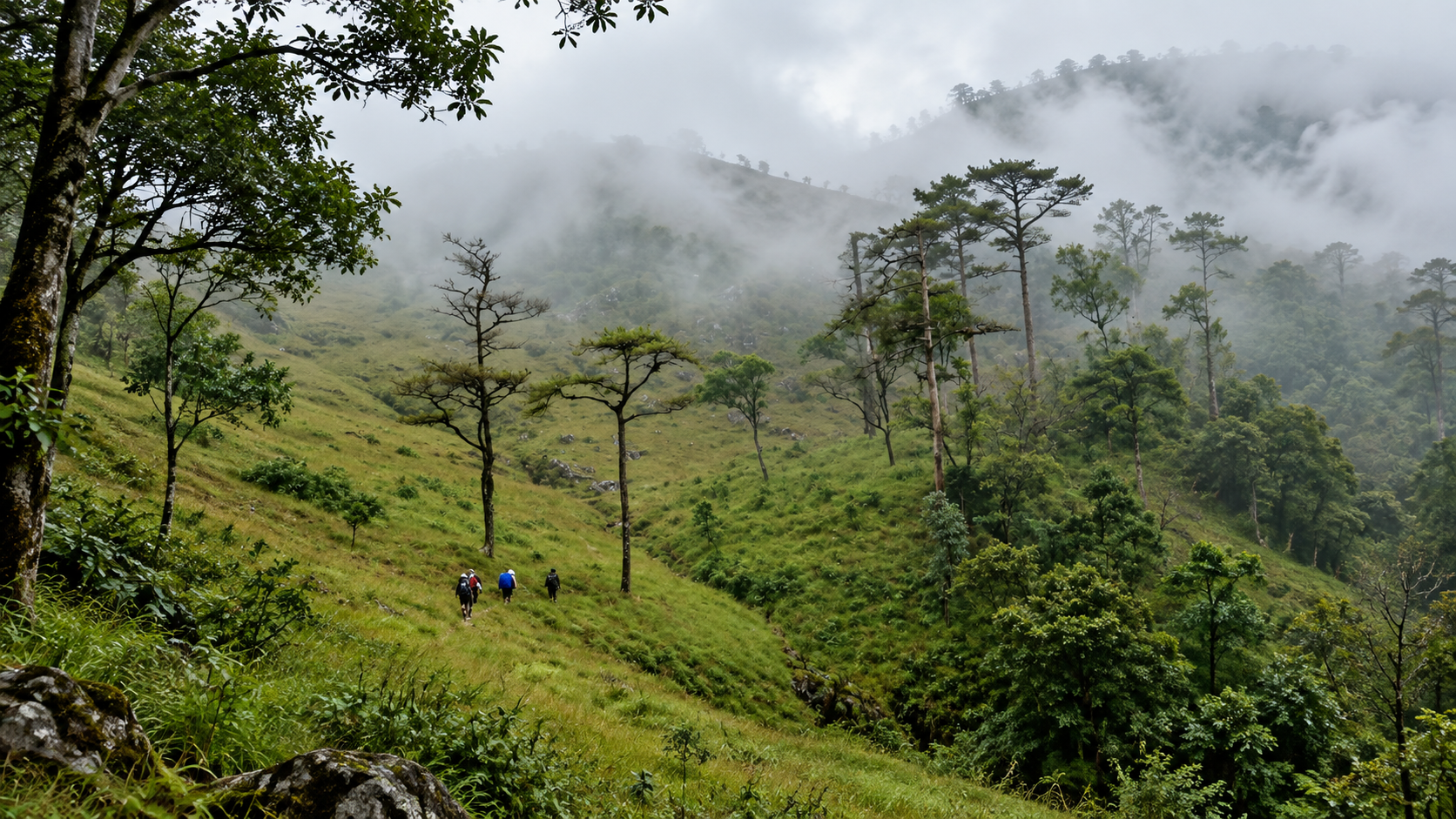
Doi Langka is not simply a point on a map. It is a long high-elevation mountain environment. The trek passes through evergreen forest, pine forest, open ridge, montane vegetation, highland grassland and exposed summit terrain. The higher you climb, the more the forest changes — dense woodland at lower elevation, pine and montane forest higher up, open highland vegetation near the ridge, and at the summit: wind, sky and mountains.
This vertical transition is one of Khun Chae’s defining ecological experiences.
The Doi Langka Trek
4 days. 3 nights. One mountain.
The classic Doi Langka Luang trek is a serious multi-day mountain journey. Traditional park information describes 4 days / 3 nights, with camping along the route and coordination with park officials. Current travel information also emphasises that the route is seasonally managed and requires advance coordination with the park — not a walk-in trail that visitors can simply start independently.
Doi Langka should not be marketed as a short hike to a beautiful viewpoint. It is a genuine mountain trek. Expect long walking days, steep ascents and descents, uneven terrain, changing weather, cold nights, limited facilities, camping, high exposure on ridge sections and physically demanding conditions. A traveller should be adequately prepared.
The reward is not simply reaching the summit. It is the gradual change in landscape. You start in forest. Then the trees change. The horizon opens. Clouds move beneath the ridge. Other mountains appear. The valleys become distant. Finally, the North opens around you. On clear days, the ridge provides broad views across the surrounding mountain systems of northern Thailand.
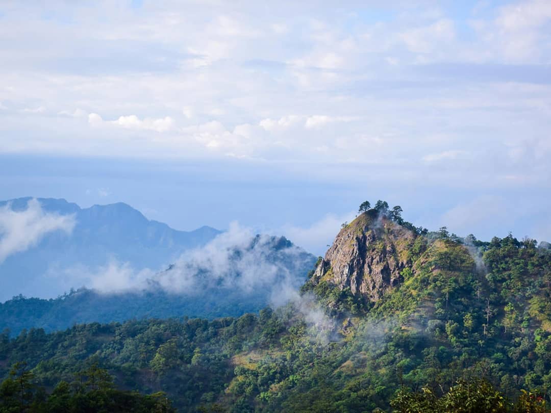
Doi Langka is particularly famous among trekkers for sunrise and a sea of clouds. Cold-season mornings can transform the valleys below into a blanket of white cloud. The mountain ridges appear above it. The experience is almost surreal. Cloud and weather conditions are never guaranteed. Nature decides.
Doi Mot — The Quiet High Mountain
Doi Mot is another important highland destination inside Khun Chae. Its summit is approximately 1,700 metres — considerably lower than Doi Langka, but still high enough for a major change in vegetation and climate. The route passes through moist forest containing ground orchids, ferns, moss and dense undergrowth. The atmosphere remains cool and shaded for much of the ascent.
Doi Mot demonstrates an important principle of mountain ecology: elevation changes everything. As elevation increases, temperature decreases, vegetation changes, humidity changes, species composition changes, forest structure changes. A relatively short horizontal distance can therefore contain several different ecological environments.
Local descriptions explain the name as having evolved from “Doi Mot / Doi Mod,” with traditional interpretations connecting the open summit to strong winds. The exposed high point is notably different from the dense forest encountered during the climb. ThailandLover describes this as a local interpretation of the mountain’s name — keeping the story without turning folklore into established history.
Doi Pha Ngom and Doi Sanka
- Doi Pha Ngom
- A prominent mountain in the central portion of the park. Its name reflects a steep, exposed rock face. The mountain extends broadly from west to east and contains montane forest, mixed deciduous forest and pine forest. It is suited to hiking and mountain scenery rather than casual roadside sightseeing.
- Doi Sanka
- Another high-elevation mountain within the park, forming part of the broader trekking landscape. The area is important for forest, watershed, highland biodiversity, trekking and panoramic mountain views. Doi Sanka, Doi Mot and Doi Pha Ngom are all listed among the park’s designated attractions and trekking areas.
Khun Chae Waterfall — The Namesake Cascade
Khun Chae Waterfall has six tiers and is one of the park’s signature attractions: a natural cascade descending through forest and rock formations. The area around the waterfall provides picnic space, forest atmosphere, streams and camping opportunities.
Traditional visitor information describes approximately two hours by vehicle from the park headquarters area, followed by approximately one hour on foot to reach the waterfall. Actual travel time can vary according to road and trail conditions.
It is more than a scenic attraction. It is the namesake of the entire national park. The sequence is mountain → forest → stream → Khun Chae Waterfall → Khun Chae National Park. In other words, the park’s identity begins with water.
Mae Tho Waterfall — The Seven-Level Cascade
Mae Tho Waterfall is one of the park’s most accessible major waterfall experiences. It has seven levels, with the highest drop reaching approximately 40 metres. The waterfall originates from the mountain watershed and descends through forested terrain.
The route can be reached by vehicle from the headquarters area toward the Mae Tho trailhead. Traditional park information describes approximately 30–40 minutes by vehicle, followed by approximately two hours to explore the waterfall levels. The exact accessibility of individual levels should always be checked with the park before travel.
Mae Chang Khao Reservoir
Mae Chang Khao Reservoir is one of the quieter attractions of Khun Chae. Compared with the dramatic waterfalls and high mountain trekking routes, the reservoir offers a slower experience — water, forest, mountain scenery, relaxation and local recreation. Visitor information has described raft-style leisure activities on the reservoir.
The Giant Fig Tree
Near the park headquarters stands one of Khun Chae’s most unusual natural landmarks: the giant fig tree. The tree’s enormous canopy and aerial roots create a miniature forest of their own. Historical descriptions recorded a canopy area of more than 1,600 m², making it one of the park’s most memorable botanical landmarks.
This is a perfect example of why biodiversity is not always about rare animals. Sometimes one tree is an ecosystem.
The Forests of Khun Chae
Khun Chae’s vegetation changes dramatically with elevation. Historical park descriptions identify a broad vertical sequence:
- 300–800 m
- Bamboo forest and mixed deciduous forest. Warmer, more seasonal. During the dry season, much of the landscape can appear markedly more open.
- 800–1,000 m
- Evergreen forest and dry dipterocarp forest. Humidity rises. The forest becomes darker. Mosses and ferns become more common. This is the transition between northern dry forest and high mountain forest.
- 1,000–1,500 m
- Evergreen forest and pine forest. Vertical trunks create open woodland, filtered light, dry needles on the ground and mountain views — particularly atmospheric during the cool season.
- Above 1,500 m
- Montane evergreen forest — the environment of Doi Mot, Doi Pha Ngom, Doi Sanka and Doi Langka. Moss, ferns, orchids, small shrubs, mountain grasses, and noticeably cooler air.
Khun Chae can be read vertically. Lowland: warm, seasonal, deciduous. Mid-elevation: cooler, greener, more humid. High mountain: cold, misty, montane. This is why the park can feel like several different ecosystems within one protected area.
Geology, Water and the Watershed
Khun Chae’s mountains are geologically complex. The landscape contains both igneous rock and sedimentary rock. Granite is particularly widespread. Other geological materials include basaltic volcanic rock, sandstone and shale. These rocks weather differently. Their interaction with rainfall and erosion has helped create ridges, cliffs, valleys, waterfalls and exposed rock faces. Historical park descriptions identify granite as the dominant rock in much of the area.
Granite forms when molten material cools slowly underground. Over geological time, uplift and erosion expose the rock. Weathering then breaks it down. Rainwater follows fractures. Streams deepen valleys. Slopes collapse. And mountains gradually take their present form.
The mountains are high. But water gives them their shape. Rain enters the forest, soaks into the mountain, emerges as springs and streams, flows through rock, cuts valleys, creates waterfalls, and feeds downstream rivers. Khun Chae is fundamentally a watershed landscape.
Doi Langka and surrounding mountains feed streams that eventually join the wider river systems of northern Thailand. Traditional geographical description identifies the area as an important source of streams feeding the Lao River, which ultimately joins the Kok River system. This gives the park importance far beyond tourism.
A mountain forest stores water. It slows runoff. It stabilizes soil. It protects springs. It maintains stream flow. And it supports agriculture downstream. The forest above the village is part of the village’s water infrastructure. This is one of the most important ways to understand Khun Chae.
Wildlife and Bird Life
Khun Chae supports a diverse northern Thai forest fauna. Reported mammals include leopard cat, barking deer, wild boar, porcupine, civets, squirrels, slow loris, gibbon, serow and bear. Historical park descriptions list these among the wildlife that may occur in the forest.
Khun Chae is not a wildlife safari park. Even if a species is documented, that does not mean visitors will see it. The best sign of a healthy forest may be that the animals remain difficult to find. Look for footprints, droppings, feeding marks, scratches, calls, nests and movement in the canopy — rather than expecting a close encounter.
The park is particularly interesting for birdwatchers because it contains several elevational forest zones. Reported birds include Grey Treepie and other woodland birds, Crested Serpent Eagle, Shikra, Grey-headed Flycatcher, Coppersmith Barbet, Blue-throated Barbet, Blue-winged Leafbird, White-fronted Forktail and wild junglefowl. Historical park information also records numerous other forest bird species.
At higher elevations, the bird community changes. Pine and montane forests provide habitat for species that are less commonly encountered in lowland forests. For serious birdwatchers, the high-elevation trek is therefore not just a hiking experience. It is a vertical birdwatching journey.
Orchids, Ferns and the Forest After Rain
One of the most beautiful aspects of Khun Chae is its smaller vegetation. Along the Doi Mot route, visitors encounter ground orchids, ferns, moss and small forest plants. The higher and wetter the forest becomes, the more prominent these plants are. They form the soft green layer beneath the larger trees.
After rainfall, Khun Chae changes dramatically. Moss becomes brighter. Ferns unfold. Streams strengthen. Waterfalls become louder. Clouds settle between ridges. The forest floor becomes reflective. This is when the park feels most intensely alive.
Climate, Fire Season and When to Go
Because the park ranges from low elevations to more than 2,000 metres, temperatures vary significantly with altitude. At the high ridges: cold mornings, strong winds and very low temperatures in winter. At lower elevations: warmer daytime temperatures. Visitors can experience completely different weather within the same park.
- Cool season · November–February
- Generally the best period for Doi Langka, Doi Mot, mountain trekking, camping, sunrise, sea of clouds and highland photography. Traditional park guidance identifies November–March as the most suitable general tourism period.
- Rainy season
- Green forests, strong waterfalls, mist and cool mountain air — but also slippery trails, leeches in some forest environments, rapidly changing weather, possible flash-water hazards and route closures. Always check the park’s current announcement.
- Dry season
- The lower forest becomes drier, warmer and more open. Leaves fall. Grass dries. Fire risk rises. Visibility may be affected by regional smoke and haze. Never light fires outside designated areas, and never discard cigarettes or other ignition sources.
- Seasonal closure
- The DNP’s published closure schedule lists 1 June–30 September as a period when major tourism and accommodation areas are closed, including Doi Sanka, Doi Mot, Doi Pha Ngom, Khun Chae Waterfall, Mae Chang Khao Reservoir, the headquarters zone and the Khun Chae campground. Closure dates can be revised — confirm the latest annual announcement before travel.
For Doi Langka, November–February brings cooler weather, drier trail conditions, clearer mountain views, a higher chance of sea of clouds and more comfortable trekking temperatures. For waterfalls, the rainy and post-rain period generally produces stronger flow — but more water can also mean more difficult access. The ideal date is a period when sufficient rainfall has occurred but the route is safe and officially open.
The classic sea-of-clouds sequence is a cold night, a moist valley, morning temperature inversion, cloud forming below the ridge — then a sea of clouds. Especially early morning after cool nights with sufficient moisture, from November to February.
The Road to Khun Chae
The principal access route is Highway 118, the Chiang Mai–Chiang Rai road. The park is positioned directly along this travel corridor, making it comparatively accessible by car despite its wilderness character. Headquarters is in Mae Chedi Mai, Wiang Pa Pao District.
- From Chiang Mai
- Approximately 100 km northeast, depending on the exact starting point. The drive follows Highway 118 through Doi Saket, mountain country, Mae Khachan and Wiang Pa Pao. The journey itself is part of the experience.
- From Chiang Rai
- The park lies southwest of Chiang Rai city. Visitors travel toward Wiang Pa Pao along Highway 118 before turning toward the park facilities. Exact travel distance depends on the entrance point and route.
This is one of Khun Chae’s strongest advantages. You can combine Chiang Mai → Doi Saket → Khun Chae → Wiang Pa Pao → Chiang Rai. The park works exceptionally well as a nature stop on a northern Thailand road journey.
Who Should Visit
Khun Chae is not a resort park. It is not designed primarily around luxury resorts, large tourist crowds, amusement attractions or roadside cafés. Its core value is mountain + forest + water + trekking. That makes it particularly suitable for travellers who want a more serious nature experience.
- The trekker
- For Doi Langka.
- The mountain photographer
- For high ridges, mist, sunrise and pine forest.
- The birdwatcher
- For changing forest habitats across elevation.
- The waterfall lover
- For Khun Chae and Mae Tho.
- The camper
- For cool nights and dark mountain skies.
- The slow traveller
- For a quieter alternative to northern Thailand’s better-known parks.
If your only available time is 30 minutes, Khun Chae is not the right destination. If you want 3–4 hours, choose a waterfall or short forest experience. If you want 2–4 days, then Khun Chae begins to reveal its real identity — especially Doi Langka.
How to Experience It
A one-day outline
- Morning
- Arrive early. Explore the headquarters area. See the giant fig tree.
- Late morning
- Continue toward Mae Tho Waterfall. Walk the accessible waterfall route.
- Afternoon
- Return toward Mae Chang Khao Reservoir. Relax beside the water.
- Late afternoon
- Return toward park headquarters.
- Evening
- Camp if current regulations permit. Watch the sky change.
A two-day experience
- Day 1
- Chiang Mai or Chiang Rai → Khun Chae → Mae Tho Waterfall → Mae Chang Khao Reservoir → camping → stars.
- Day 2
- Early morning forest → Doi Mot route if officially open → return → continue north or south along Highway 118.
The four-day Doi Langka experience
- Day 1
- Approach the mountain. Enter highland forest. Camp.
- Day 2
- Continue climbing. Forest changes. Pine appears. Reach higher ridge. Camp.
- Day 3
- Traverse the high ridge. Clouds. Wind. Mountain panoramas. Approach Doi Langka.
- Day 4
- Summit. Sunrise. Descend. Exit the mountain. Return to civilisation.
This is the kind of experience that turns Khun Chae from “another national park” into a mountain memory.
Sound, Light and the Character of the Ridge
Doi Langka is not spectacular because it has a single dramatic cliff. It is spectacular because of distance, altitude, silence, weather, ridge, cloud, forest and scale. The mountain rewards people willing to walk slowly enough to experience it.
- The sound of Khun Chae
- Low elevation: insects, birds, water. Mid forest: wind, leaves, streams. High ridge: wind, silence, cloud. Waterfall: constant water. Night: frogs, crickets, owls. The sound changes with elevation.
- The light of Khun Chae
- Morning: blue mist, soft forest, cold sunlight. Midday: deep green vegetation, bright water. Afternoon: golden mountain ridges. Sunset: orange mountains, purple valleys. Night: dark sky, stars. Khun Chae is as much a destination for light as it is for mountains.
Responsible Travel and Safety
Khun Chae is a protected mountain ecosystem. Treat it accordingly.
- Do not feed wildlife — especially animals that may become habituated
- Do not pick or collect plants — orchids, mosses and wild plants belong to the forest
- Do not collect rocks — the mountain is geological heritage
- Do not leave food waste — organic waste can alter wildlife behaviour
- Do not start unauthorised fires — northern Thailand has severe seasonal fire risk
- Do not play loud music — especially in camping areas
- Do not leave the designated trail — mountain terrain can become dangerous quickly
For a multi-day high mountain trek, bring adequate drinking water, food, tent, sleeping bag, warm clothing, rain protection, headlamp, first-aid kit, navigation equipment, power bank and proper hiking shoes. Most importantly: arrange the trek with the park. The Doi Langka route is seasonally managed and is not a casual walk-in trail.
At 2,031 metres, the weather can be completely different from the valley. You may leave the trailhead under sunshine and reach the ridge in cloud, wind and cold. Always pack for mountain conditions.
Although caves are part of the wider attraction profile of Khun Chae, cave access must be treated cautiously. Never enter an unfamiliar cave during heavy rain. Water can rise rapidly underground. Only enter caves that are officially open, and follow local guidance.
Why Khun Chae Matters
Khun Chae is valuable because it protects a high mountain watershed. The park’s forests provide water — headwaters and streams; biodiversity — different habitats across elevation; carbon storage; soil protection; wildlife habitat from small mammals to mountain species; and a climate refuge, as high elevations offer cooler environments.
One of the most fascinating ways to understand Khun Chae is vertically. At 500 m: warm seasonal forest. At 1,000 m: cooler evergreen forest. At 1,500 m: pine and montane forest. At 2,031 m: high mountain ridge. This is not merely altitude. It is a change of climate in one landscape.
Khun Chae sits near several important protected landscapes. It adjoins or lies close to Chae Son National Park, Mae Takhrai National Park and Si Lanna National Park. This regional connection makes the park more valuable than its 270 km² area alone suggests. Wildlife does not understand administrative boundaries. A forest corridor is therefore more important than a single park polygon.
The surrounding protected-area system around the Khun Tan and neighbouring ranges provides opportunities for wildlife movement, watershed protection, ecological connectivity and climate resilience — particularly important for larger mammals that need extensive habitat.
The Quiet National Park
Compared with Thailand’s most famous parks, Khun Chae receives relatively little international tourism. That is part of its appeal. There are no giant crowds at every viewpoint. No constant stream of tour buses. No endless rows of commercial attractions. Instead: forest, mountains, waterfalls, wind, clouds. That quietness is increasingly valuable.
ThailandLover should not present Khun Chae as “another beautiful national park in Chiang Rai.” That would miss the point. The stronger positioning is: one of Northern Thailand’s high-mountain wildernesses, centred around a 2,031-metre summit and a dramatic vertical sequence of forests, waterfalls and cloud-covered ridges.
- Khao Yai
- Wildlife and accessible forest.
- Doi Inthanon
- Thailand’s highest mountain and famous highland attractions.
- Doi Chiang Dao
- Limestone mountain and endemic high-altitude ecosystem.
- Doi Pha Hom Pok
- High mountain, sunrise and borderland wilderness.
- Khun Chae
- The quiet high-mountain wilderness of the Khun Tan Range. Its identity is altitude + forest + water + solitude.
The real attraction of Khun Chae is not Doi Langka alone. It is the transition: road → valley → forest → waterfall → evergreen forest → pine → montane forest → cloud → Doi Langka. The journey itself is the destination.
At lower elevation, you feel Thailand. At higher elevation, you begin to feel the mountains. And at 2,031 metres, you are looking across an entirely different world. That is Khun Chae.
Don’t Miss
- Doi Langka Luang
- Doi Mot
- Doi Pha Ngom
- Doi Sanka
- Khun Chae Waterfall
- Mae Tho Waterfall
- Mae Chang Khao Reservoir
- The giant fig tree
Best for: trekking · mountains · waterfalls · camping · birdwatching · forest · photography · sunrise · sea of clouds · slow travel.
Frequently Asked Questions
- What is Khun Chae National Park?
- Thailand’s 80th national park, established on 14 August 1995. Approximately 168,750 rai / 270 km² in Wiang Pa Pao, Chiang Rai, within the Khun Tan Range. Highest summit: Doi Mae Tho / Doi Langka Luang at about 2,031 metres.
- Where is it?
- Wiang Pa Pao District, Chiang Rai, along Highway 118 between Chiang Mai and Chiang Rai. Headquarters is in Mae Chedi Mai Subdistrict.
- How high is Doi Langka?
- Approximately 2,031 metres. It is the highest summit of the Khun Tan Range, also known as Doi Langka Luang and Doi Mae Tho.
- Is the Doi Langka trek a day hike?
- No. Traditional park information describes a 4-day / 3-night mountain trek with camping. Arrange it with the park in advance. It is not a walk-in viewpoint trail.
- When is the best time to visit?
- November–March for general travel. November–February for Doi Langka, camping, sunrise and sea of clouds. Waterfalls are stronger after rain if routes are officially open.
- Is the park closed in the rainy season?
- Major tourism and camping areas have historically been closed 1 June–30 September. Confirm the current annual announcement before travelling.
- How do I get there from Chiang Mai?
- Approximately 100 km northeast along Highway 118, through Doi Saket, mountain country, Mae Khachan and Wiang Pa Pao.
Nearby Destinations
- Mae Takhrai National Park
- A neighbouring forest landscape in the Chiang Mai–Lamphun highlands, part of the same mountain corridor.
- Si Lanna National Park
- Lakes, forest and highland scenery along the Chiang Mai side of this northern protected-area network.
- Chae Son National Park
- Waterfalls and hot springs in Lampang, adjoining the wider Khun Tan mountain world.
- Mae Tho National Park
- High forest on the Chiang Mai–Lampang side of the same mountain range, close to Doi Mae Tho.
- Doi Khun Tan National Park
- The classic Khun Tan Range park — railway, pine forest and the mountain that gives the range its name.
- Doi Inthanon National Park
- Thailand’s highest mountain — a useful contrast if you want the famous highland, not the quiet one.
Location
Find Khun Chae National Park
Mae Chedi Mai, Wiang Pa Pao, Chiang Rai · Highway 118