

National Park · UNESCO World Heritage
Khao Yai National Park
อุทยานแห่งชาติเขาใหญ่
Where Thailand’s Forest Begins
Saraburi · Nakhon Nayok · Nakhon Ratchasima · Prachin Buri
A ThailandLover guide to Thailand’s first national park — a vast mountain forest of waterfalls, grasslands, wildlife and ecological corridors at the heart of central and northeastern Thailand.
More Than a National Park
There are places in Thailand that are beautiful. And then there are places that explain why Thailand still has forests. Khao Yai is one of them.
Established in 1962 as Thailand’s first national park, Khao Yai marked a fundamental change in the country’s approach to conservation. What was once a difficult and largely inaccessible mountain wilderness became the beginning of Thailand’s national-park system.
Today it is not simply a destination for waterfalls and weekend escapes. It is a vast ecological landscape connecting mountains, forests, grasslands, rivers and wildlife across four provinces — and the western gateway to the Dong Phayayen–Khao Yai Forest Complex, a UNESCO World Heritage property extending roughly 230 kilometres eastward toward the Cambodian border.
Khao Yai is both a destination and a living piece of Thailand’s natural infrastructure.
At a Glance
- Official Name
- Khao Yai National Park
- Thai Name
- อุทยานแห่งชาติเขาใหญ่
- Established
- 18 September 1962
- Status
- Thailand’s first national park
- Provinces
- Nakhon Ratchasima, Nakhon Nayok, Prachin Buri, Saraburi
- Area
- Almost 2,206 km² (current official presentation)
- Historical area record
- 2,168.75 km² / 1,355,468.75 rai
- Highest Peak
- Khao Rom — approximately 1,351 m
- ASEAN Heritage Park
- Designated 1984
- UNESCO
- Dong Phayayen–Khao Yai Forest Complex · inscribed 2005
- Birdlife
- 280+ species in the park; 392 across the World Heritage complex
- Park hours
- 06:00–18:00 · visitor information 08:30–16:30
The difference between almost 2,206 km² and 2,168.75 km² reflects different official presentations over time. For a current destination profile, the park’s current website figure of approximately 2,206 km² is the appropriate headline.
The First National Park of Thailand
Before Khao Yai, Thailand did not yet have a national-park system in the modern sense. In 1959, Prime Minister Field Marshal Sarit Thanarat initiated that system, with advice from Dr G.C. Ruhle of the International Union for Conservation of Nature. The first major result was Khao Yai.
On 18 September 1962, Khao Yai was officially proclaimed Thailand’s first national park. That date is more important than it may first appear. Khao Yai became the model for protecting forests, watersheds, wildlife habitats and important landscapes for future generations. From here, the national-park system would eventually expand across mountains, forests, islands, wetlands and marine ecosystems throughout the country.
Khao Yai was the beginning.
Four Provinces, One Forest
Khao Yai is unusual because its landscape does not belong to a single province. The park’s official historical area page identifies 11 districts across four provinces, with Prachin Buri holding the largest share of the park’s area. This is why Khao Yai should not be thought of simply as “a mountain near Pak Chong.”
- Nakhon Ratchasima
- The northeastern gateway, particularly around Pak Chong and Mu Si — the most internationally familiar entrance.
- Nakhon Nayok
- The western/southern side, toward the Noen Hom area, connecting the park with the Nakhon Nayok landscape.
- Prachin Buri
- A substantial portion of the park, forming part of the eastern forest landscape.
- Saraburi
- The western portion, linking Khao Yai with the broader forest and watershed system toward the central plains.
The Mountains of Khao Yai
Khao Yai occupies a complex mountainous landscape along the western edge of the Khorat Plateau. Terrain rises from lower elevations into ridges, high plateaus, valleys and forested slopes. The highest summit is generally identified as Khao Rom, approximately 1,351 metres — a figure supported by recent research hosted by Thailand’s Department of National Parks and by UNESCO’s description of the wider Dong Phayayen–Khao Yai landscape.
Another important high-elevation area is Khao Khiao, approximately 1,290 metres. It contains the famous Pha Trom Jai / Khao Khiao viewpoint, where elevation, clouds, mist and montane vegetation create a distinctly different environment from the lower forest.
A Forest of Many Forests
One of Khao Yai’s greatest ecological strengths is that it is not a single uniform forest. The official park describes dry evergreen forest, mixed deciduous forest, lower montane rain forest, tropical rain forest, secondary forest and grassland.
- Dry evergreen forest
- Approximately 840,000 rai
- Mixed deciduous forest
- Approximately 287,000 rai
- Lower montane rain forest
- Approximately 111,187 rai
- Tropical rain forest
- Approximately 59,000 rai
- Grassland
- Approximately 51,835 rai
Khao Yai sits where different monsoonal influences contribute to substantial rainfall. Mountains intercept moisture, feeding streams and tributaries: forest → stream → waterfall → river → agricultural plain. UNESCO identifies the wider complex as a critically important watershed for the Nakhon Nayok, Prachin Buri, Lam Takhong, Muak Lek and Mun river systems. Protecting Khao Yai is also protecting water.
The Grasslands
Khao Yai is not simply endless rainforest. Large open grasslands appear between forested mountain areas — Nong Phak Chi, Khao Laem, Bueng Phai, Khlong E-Tao, Nong Khing. Some have historical origins in former villages and agriculture before the park was established. Today they are important wildlife habitat.
At Nong Phak Chi, wildlife can use open areas and artificial salt licks as feeding grounds. Animals recorded around the observation tower include sambar deer, barking deer, wild boar, Asian elephant, gaur and dhole. The grassland is not empty space between forests. It is part of the ecosystem.
Wildlife & the Bird Kingdom
The wider Dong Phayayen–Khao Yai Forest Complex supports more than 800 recorded fauna species, including 112 mammals, 392 birds and 200+ reptiles and amphibians. Wildlife sightings are never guaranteed. That is exactly the point. Khao Yai is not a zoo. It is a functioning wild ecosystem.
- Asian elephant
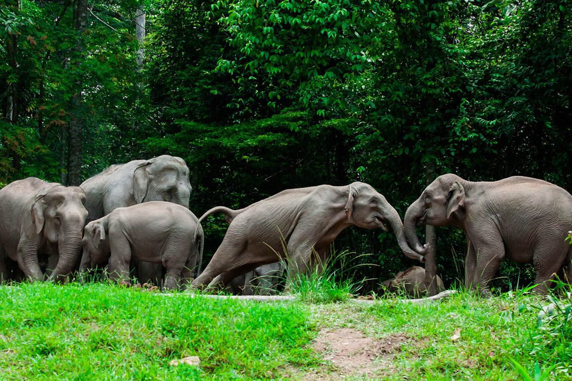
- Elephas maximus. One of Khao Yai’s most iconic animals, moving between forest, grassland and water — a clear indicator that this remains a large-scale forest ecosystem.
- Gaur, deer and wild boar
- Gaur is one of Southeast Asia’s largest wild bovids. Sambar and barking deer, with wild boar, are part of the grassland and forest food web.
- Elusive predators
- Dhole, Asiatic black bear, clouded leopard and tiger belong to the wider complex. Visitors should never expect to see a tiger. Several of these species are Endangered or Vulnerable.
- Hornbills and forest birds
- The park describes more than 282 bird species. Four hornbills are specifically highlighted: Great, Oriental Pied, Wreathed and Austen’s Brown. Also associated: Siamese fireback, Blue-winged pitta, Coral-billed ground cuckoo. Early morning is generally the most productive period.
Nong Phak Chi — Where the Forest Comes to Drink
The observation tower is approximately 20 metres high, overlooking open grassland and a water source used by wildlife, with salt licks that provide minerals for herbivores. Potential sightings include sambar, barking deer, wild boar, Asian elephant, gaur and dhole. The key word is potential. Wildlife decides when it appears. That uncertainty is what makes Nong Phak Chi different from a conventional attraction.
Haew Narok, Haew Suwat and Pha Kluai Mai
- Haew Narok Waterfall
- น้ำตกเหวนรก. The largest and tallest major waterfall in Khao Yai, descending approximately 150 metres through three tiers. The upper section drops over a near-vertical cliff. Swimming is prohibited. The area lies within wild elephant range. In 1992, eight elephants died near the upper waterfall; in October 2019, another 11 were lost. Haew Narok is a viewpoint and a reminder of the risks of living alongside large wild animals.
- Haew Suwat Waterfall
- น้ำตกเหวสุวัต. Approximately 25 metres high, on the Lam Takhong stream system, dropping over distinctive volcanic rock. Internationally recognisable after appearing in the film The Beach — and still one of the park’s most accessible waterfalls even without the cinematic association.
- Pha Kluai Mai
- น้ำตกผากล้วยไม้. Another Lam Takhong waterfall landscape, especially interesting for orchids, ferns, stream ecosystems and forest photography. Trails toward Haew Suwat pass Siamese rosewood, agarwood and dense fern communities.
Pha Diew Dai, Khao Khiao and Km. 30
Pha Diew Dai is one of Khao Yai’s signature viewpoints: a cliff about 900 metres above sea level, with a stone platform looking across the Rom Khwang range, Thung Nguluam, Khao Samor Poon and the plains toward Prachin Buri. It is particularly associated with sunrise. The approach is a nature trail of about 450 metres through high-elevation forest.
At around 1,290 metres, Khao Khiao / Pha Trom Jai becomes cooler and more humid. Mosses, lichens, ferns and montane plants become prominent. Clouds can move rapidly across the ridge. For visitors who only associate Khao Yai with waterfalls and grasslands, this is another personality: a high mountain environment within easy reach of Thailand’s central region.
The Km. 30 Viewpoint, along Thanarat Road, is one of the classic roadside stops toward the northern landscape — an easier scenic stop for visitors who are not planning a long hike.
Sai Sorn Reservoir
Rather than dramatic cliffs or giant waterfalls, Sai Sorn is still water, forest, open sky, mountain silhouettes and changing evening light. The park specifically recommends it as a sunset destination. It is also connected to one of Khao Yai’s official nature trails.
Seven Nature Trails — and the Forest at Night
Khao Yai officially provides seven short nature-trail routes, from about 1.2 to 8 kilometres. Difficulty and guide requirements vary.
- Dong Tiw – Sai Sorn Reservoir
- 2.7 km one way · about 1.5–2 hours · guide required. Dry and secondary forest, birdwatching and vegetation.
- Dong Tiw – Nong Phak Chi
- 5.5 km one way · about 3 hours · guide required.
- Km. 33 – Nong Phak Chi
- 4.2 km one way · about 2.5–3 hours · guide required.
- Visitor Center – Haew Suwat
- 8 km one way · about 6 hours · guide mandatory. Mixed forest, bamboo and elephant habitat. The park warns that the route can be confusing.
After sunset, Khao Yai changes. The Night Safari may reveal sambar, Malayan porcupine, civets, wild elephants, owls and nightjars. Visitors are not permitted to drive their own vehicles at night to search for wildlife. The park uses designated vehicles and guides. Wildlife watching should never become wildlife chasing.
UNESCO, ASEAN and the Greater Forest
Khao Yai is the western anchor of the Dong Phayayen–Khao Yai Forest Complex: Khao Yai, Thap Lan, Pang Sida, Ta Phraya National Park and Dong Yai Wildlife Sanctuary. Together the World Heritage property covers approximately 615,500 hectares (about 6,155 km²) and stretches about 230 kilometres from Khao Yai toward the Cambodian border. It was inscribed in 2005 under natural criterion (x).
Khao Yai was designated an ASEAN Heritage Park in 1984 — regional importance, not merely tourist popularity. The wider complex contains at least 2,500 plant species, roughly one-sixth of Thailand’s known plant diversity according to the park’s heritage documentation, plus 805 animal species. Large mammals do not stop at a visitor-map boundary. For elephants, gaur and predators, the value of Khao Yai is the size of the whole complex.
A Forest That Was Once a Frontier
The modern landscape looks timeless. It is not. Before the park, the area was associated with settlements, agriculture and forest exploitation. Former villages and fields eventually became some of the grasslands now seen around the park. Conservation did not simply preserve an untouched wilderness. In many places, it allowed a damaged landscape to recover.
The name Khao Yai literally means “Big Mountain.” Historically it referred to a long range separating the Central and Northeastern regions. The old Dong Phaya Yen forest was regarded as a difficult, dangerous wilderness to cross. Roads make Khao Yai comparatively accessible today. Once visitors leave the road, the scale becomes much more apparent.
The Chao Phor Khao Yai Shrine on Thanarat Road represents cultural memory of the mountain. Park historical accounts associate the figure with Jang Nisaisat, a local man from Nakhon Nayok. A ceremony is held annually on 26 January. For many visitors, the shrine is a symbolic threshold: the point where the settled world enters the mountain.
Thanarat Road and How to Move Through the Park
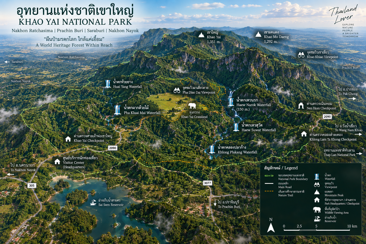
The best-known internal route is Thanarat Road — Highway 2090 — connecting Chao Phor Khao Yai Shrine, Km. 30 Viewpoint, the Visitor Center, Sai Sorn Reservoir, Pha Kluai Mai and Haew Suwat. Other approaches connect through Noen Hom and the Nakhon Nayok side. Attractions are spread across a large landscape; the park recommends reaching the entrance, then arranging onward transport inside.
You can visit Khao Yai in one day. You cannot really understand it in one day. A day trip can cover Haew Narok, Pha Diew Dai, Km. 30, Haew Suwat and Sai Sorn. Overnight adds early-morning forest, bird activity, sunset, darkness, stars, Night Safari and camping. The official park publishes one-day and two-day itineraries, including accommodation or camping.
When to Go
- November–February
- Generally the most comfortable period for camping, hiking, birdwatching, sunrise and wildlife observation. Mornings can feel crisp.
- March–May
- Warmer; some open landscapes become drier. Wildlife may concentrate around remaining water sources.
- June–October
- Intensely green. Streams strengthen, waterfalls become more dramatic, moss and fungi become prominent. Trails can be slippery, streams can rise rapidly, and some routes may close. Check conditions before hiking.
How Different Travellers Use Khao Yai
- First-time visitors
- Haew Narok, Km. 30, Visitor Center, Haew Suwat, Sai Sorn Reservoir.
- Photographers
- Pha Diew Dai, Khao Khiao, Sai Sorn, Haew Narok, Haew Suwat, morning grasslands and mist after rain.
- Birdwatchers
- Early morning, forest trails, Pha Kluai Mai, Nong Phak Chi, Visitor Center, Khao Khiao and quiet forest roads.
- Wildlife watchers
- Nong Phak Chi, grasslands, water sources, dusk and Night Safari — remembering that wildlife cannot be ordered on demand.
- Hikers
- The official nature-trail system. Some routes are short; others require several hours and a mandatory guide.
A strong two-day shape: Day 1 waterfalls and high mountains (Haew Narok, Pha Diew Dai, Khao Khiao, Haew Suwat, Sai Sorn sunset, Night Safari). Day 2 forest and wildlife (early birds, Nong Phak Chi, a nature trail, Pha Kluai Mai). Leave slowly. Khao Yai is often most beautiful when the forest begins to soften into evening.
Responsible Travel
Khao Yai is one of the places in Thailand where responsible tourism is not a slogan. It is necessary. UNESCO has recognised increasing tourism pressure as a management concern: Khao Yai receives substantially more visitors than other protected areas in the World Heritage complex. The question is not how to bring more people. It is how to let people experience Khao Yai without reducing the ecosystem they came to see.
- Never feed wildlife — food changes behaviour and creates dependence
- Never approach elephants; if one appears near the road, keep distance and follow rangers
- Do not use flash against wildlife, especially at night
- Do not leave food out at campsites or roads
- Stay on designated trails; do not create informal paths
- Do not collect plants, rocks or other natural material
- Do not enter closed areas — seasonal closures exist for safety and recovery
- Drive slowly. Roads cross wildlife habitat
Must-Experience
- 01 — Haew Narok
- The 150-metre waterfall and a lesson in sharing landscape with elephants.
- 02 — Haew Suwat
- The cinematic curtain of water on the Lam Takhong — still worth seeing without the film.
- 03 — Pha Diew Dai
- One cliff, one horizon — when the trail is open.
- 04 — Khao Khiao
- Montane mist at about 1,290 metres, a different Khao Yai from the grasslands.
- 05 — Nong Phak Chi
- Wait. Watch. Let the grassland decide what appears.
- 06 — Sai Sorn Reservoir
- Sunset, still water and mountain silhouettes.
- 07 — Night Safari
- The forest after dark, in a designated vehicle, not a private chase.
- 08 — A nature trail
- Stay overnight, wake before sunrise, listen for birds. That is when Khao Yai starts to make sense.
Essential Khao Yai
- Name
- Khao Yai National Park
- Thai
- อุทยานแห่งชาติเขาใหญ่
- Established
- 18 September 1962 · Thailand’s first national park
- Provinces
- Nakhon Ratchasima, Nakhon Nayok, Prachin Buri, Saraburi
- Area
- Almost 2,206 km² (current) · historical record 2,168.75 km²
- Highest peak
- Khao Rom · approximately 1,351 m
- UNESCO
- Dong Phayayen–Khao Yai Forest Complex · 2005 · ~615,500 ha
- Headquarters
- Mu Si, Pak Chong, Nakhon Ratchasima 30130
- Access
- Thanarat Road (2090) · Pak Chong · Noen Hom
- Hours
- 06:00–18:00 · visitor information 08:30–16:30
Frequently Asked Questions
- What is Khao Yai National Park?
- Thailand’s first national park, gazetted on 18 September 1962, across Nakhon Ratchasima, Nakhon Nayok, Prachin Buri and Saraburi. Current official presentation: almost 2,206 km². ASEAN Heritage Park (1984) and part of the UNESCO Dong Phayayen–Khao Yai Forest Complex (2005).
- Is Khao Yai only in Nakhon Ratchasima?
- No. Pak Chong is the most familiar gateway, but the park is a trans-provincial forest. Prachin Buri holds the largest share of the area.
- What are the main attractions?
- Haew Narok, Haew Suwat, Pha Kluai Mai, Pha Diew Dai, Khao Khiao, Nong Phak Chi, Km. 30, Sai Sorn Reservoir, nature trails, camping and Night Safari.
- Is Pha Diew Dai open in 2026?
- The park has announced closure of the viewpoint and nature trail from 1 June through 30 September 2026. Confirm before travel.
- Can I see wild elephants in Khao Yai?
- Possibly, never as a guarantee. Never approach, feed or block them. Follow ranger instructions.
- When is the best time to visit?
- November–February is generally most comfortable. The rainy months are greener and the waterfalls stronger, but trails can close. Check conditions.
- Is Khao Yai a day-trip destination?
- Possible, but incomplete. Overnight adds dawn, birds, sunset, Night Safari and camping.
- What are the park hours?
- 06:00–18:00. Visitor information 08:30–16:30. Visitor Centre +66 86 092 6529 · HQ +66 86 092 6527.
Related Destinations
- Thap Lan National Park
- The World Heritage forest continuing east of Khao Yai — the same complex, a quieter door.
- Pang Sida National Park
- Another piece of the Dong Phayayen forest, known for waterfalls and butterflies.
- Khao Chamao–Khao Wong National Park
- Eastern mountain forest and waterfalls, a different face of the same broad forested region.
- Khao Sip Ha Chan National Park
- A quieter Chanthaburi waterfall forest and elephant corridor in the Eastern Forest Complex.
- Nature & Parks
- More protected landscapes across ThailandLover’s national-park collection.
Location
Find Khao Yai National Park
Mu Si Subdistrict, Pak Chong District, Nakhon Ratchasima 30130