


National Park · Chanthaburi
Khao Sip Ha Chan National Park: The Hidden Waterfall Wilderness of Chanthaburi
อุทยานแห่งชาติเขาสิบห้าชั้น
Where Fifteen Tiers Meet the Wild
Kaeng Hang Maeo · Khun Song · Eastern Thailand
A quiet mountain wilderness in Chanthaburi, where forest corridors, wild elephants, cascading waterfalls and lowland evergreen forests meet.
The Eastern Forest’s Hidden Waterfall Country
Far from Chanthaburi’s famous orchards and coastline lies a different side of the province: Khao Sip Ha Chan National Park, a compact but ecologically important protected landscape built around mountains, streams and some of the Eastern Forest Complex’s remaining lowland habitat.
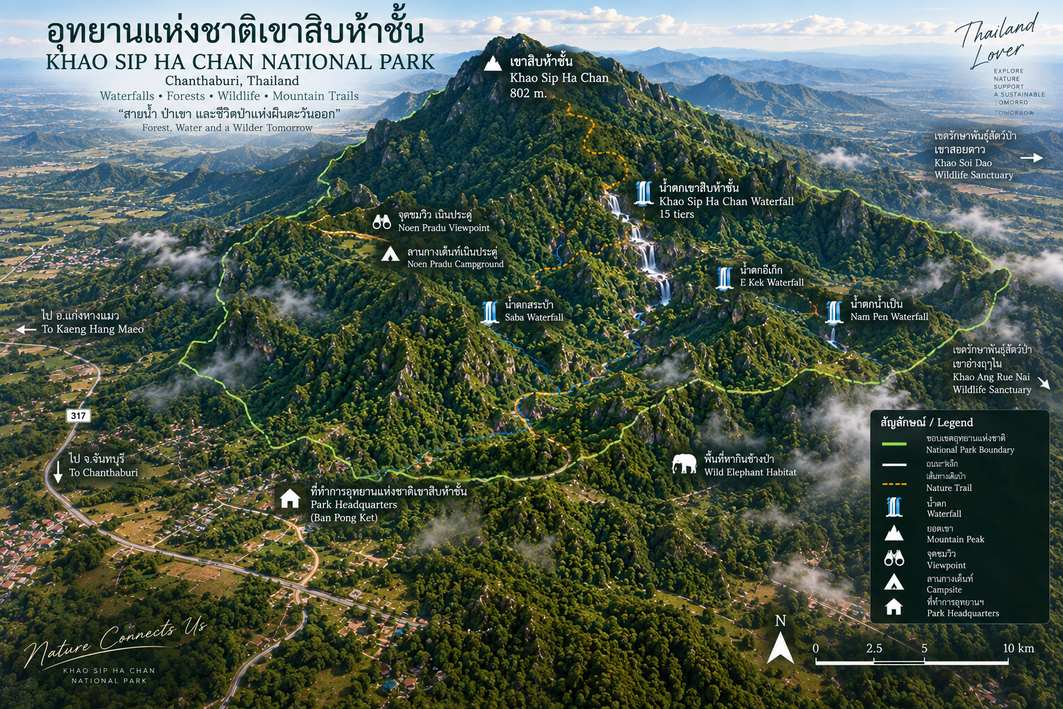
Its name comes from Khao Sip Ha Chan, the park’s highest mountain at approximately 802 metres above sea level. But the real attraction is not simply the summit. It is the landscape around it — forested ridges, lowland plains, streams and waterfalls, including the park’s signature Namtok Khao Sip Ha Chan, a multi-tiered waterfall that climbs through the forest.
More importantly, Khao Sip Ha Chan occupies a strategic position between Khao Soi Dao Wildlife Sanctuary and Khao Ang Rue Nai Wildlife Sanctuary, functioning as an important ecological corridor for wildlife in eastern Thailand — a standout in ThailandLover’s Nature & Parks collection.
Forest → Stream → Waterfall → Trail → Camp → Wildlife.
At a Glance
- Official Name
- Khao Sip Ha Chan National Park
- Thai Name
- อุทยานแห่งชาติเขาสิบห้าชั้น
- Province
- Chanthaburi
- District
- Kaeng Hang Maeo
- Area
- 73,729 rai / approximately 117.97 km²
- Rounded Figure
- Approximately 120 km²
- Highest Point
- Khao Sip Ha Chan — 802 m
- Established
- 25 December 2009
- National Park No.
- 122nd national park of Thailand
- Main Forests
- Dry evergreen · mixed deciduous · deciduous dipterocarp · secondary / grassland
- Signature Attraction
- Namtok Khao Sip Ha Chan (15 tiers)
- Other Waterfalls
- Saba · E Kek · Nam Pen
- Ecological Role
- Wildlife corridor within the Eastern Forest Complex
- Major Wildlife
- Asian elephant, gaur, wild cattle and other large mammals
- Visitor Character
- Waterfalls, hiking, camping, forest exploration
- Main Entrance
- Ban Pong Ket, Khun Song Subdistrict
- Park Telephone
- +66 98 927 1499
Contact details, fees and trail access should be reconfirmed directly with the park before travel.
Where Is Khao Sip Ha Chan?
The park is located in Kaeng Hang Maeo District, Chanthaburi Province, in eastern Thailand. It occupies part of the former Pa Khun Song National Reserved Forest, together with areas historically identified as Pa Chan Ta Pae and Pa Khao Wang Chaeng.
The area was investigated for national-park designation beginning in the early 2000s because of its combination of forest, waterfalls, water resources, biodiversity and recreational potential. It was officially established by Royal Decree and published in the Royal Gazette on 25 December 2009, becoming Thailand’s 122nd national park.
Its legally recorded area is approximately 73,729 rai, or 117.97 km². Older tourism material frequently rounds this to 75,000 rai / 120 km². For ThailandLover’s presentation, the precise figure is preferred; approximately 120 km² can be used as a rounded figure.
The Landscape
Khao Sip Ha Chan is not dominated by one dramatic mountain wall. Its character is more subtle: rolling lowland terrain and broad undulating plains, interrupted by a long north–south mountain system.
The highest point is Khao Sip Ha Chan at approximately 802 metres. Other important landforms include Khao Sa Thon in the central part of the park and Khao Saba toward the south. To the east, the mountain system extends toward Khao Soi Dao Wildlife Sanctuary. To the north, the forest landscape connects toward the larger forest complex associated with Khao Ang Rue Nai Wildlife Sanctuary.
This combination of lowland habitat and mountain forest is one of the park’s most important ecological characteristics.
The Mountain of Fifteen Tiers
เขาสิบห้าชั้น — 802 metres
The park takes its name from Khao Sip Ha Chan, the highest mountain in the protected area. At approximately 802 metres, it is not among Thailand’s highest mountains. Its significance lies elsewhere.
The mountain forms part of a larger forested landscape that collects rainfall and feeds streams flowing through the surrounding lowlands. Rather than being a conventional summit destination, Khao Sip Ha Chan is best understood as part of the park’s forest-and-water system. The mountain gives rise to streams; the surrounding valleys provide habitat for wildlife and form natural movement routes through the Eastern Forest Complex.
A Forest Built Around Water
One of the defining characteristics of Khao Sip Ha Chan is its network of streams. They are not merely scenic features. They form the ecological infrastructure of the forest — providing water for plants, wildlife and downstream communities, and creating the conditions necessary for the park’s waterfalls.
- Khlong Tonod — one of the major waterways, running through much of the landscape before flowing toward the west
- Khlong Sai
- Khlong Dinsor
- Khlong Khot
- Khlong E Kek
- Khlong Nam Pen
- Khlong Saba
- Khlong Yang
Forests of Khao Sip Ha Chan
The park is particularly interesting because it contains a mixture of forest and lowland habitats. This diversity matters: large mammals do not necessarily require dense forest everywhere. Different species use different combinations of forest, grassland, water sources and forest edges.
- Dry evergreen forest
- One of the most important forest types in the Eastern Forest Complex. It retains substantial greenery through much of the year and provides shelter, food and movement routes for wildlife.
- Mixed deciduous forest
- More visibly seasonal, with some trees shedding leaves during the drier months.
- Deciduous dipterocarp forest
- More open woodland in parts of the landscape, creating a mosaic of forest structures rather than one uniform type.
- Grassland and secondary forest
- Open habitat or regenerating forest — feeding grounds, edges and regeneration zones that large mammals also use.
Scientific research on the Eastern Forest Complex identifies dry evergreen forest as the dominant forest type, with tropical rainforest, mixed deciduous forest and deciduous dipterocarp forest also occurring across the wider complex.
The Wildlife Corridor
Where the Eastern Forests Connect
This is arguably the most important story of Khao Sip Ha Chan. The park lies within the Eastern Forest Complex and sits between major protected areas including Khao Ang Rue Nai Wildlife Sanctuary, Khao Soi Dao Wildlife Sanctuary, Khao Khitchakut National Park, Khao Chamao–Khao Wong National Park, Namtok Phlio National Park and Namtok Khlong Kaeo National Park.
Together, these protected landscapes form a much larger ecological system across eastern Thailand. Khao Sip Ha Chan acts as an important link within this system, allowing wildlife to move between larger forest blocks.
Research describes the park as an important habitat and movement corridor for wild Asian elephants, while conservation organisations have highlighted its role in connecting Khao Ang Rue Nai and Khao Soi Dao.
Wild Elephants
The Giants of the Eastern Forest
If Khao Sip Ha Chan has one wildlife story that deserves special attention, it is the Asian elephant. The park’s lowland terrain, water sources and connection to surrounding protected forests make it suitable for elephant movement and foraging.
Recent scientific research specifically identifies Khao Sip Ha Chan as an important elephant habitat and ecological connection between surrounding protected areas. A 2024 field study identified multiple wild-elephant populations using the wider landscape and documented elephant activity around the interfaces between protected forest and agricultural areas.
This also explains why the park is important beyond tourism. It is part of a landscape where wildlife conservation and human–wildlife coexistence intersect directly. The Eastern Forest Complex has experienced significant human–elephant conflict, particularly where agricultural land meets forest.
Khao Sip Ha Chan is wildlife habitat first and a tourist destination second.
Do not attempt to approach, follow or photograph wild elephants at close range.
Other Large Mammals
Reported species include Asian elephant, gaur, wild cattle / banteng, sambar deer, barking deer, wild boar, Malayan porcupine, various primates and other forest mammals. Older park descriptions also mention gibbons and monkeys, while conservation studies emphasize the park’s importance for large mammals.
These are reported wildlife species, not animals that visitors should expect to see. The forest is functioning ecosystem habitat rather than a wildlife zoo. Seeing an elephant, gaur or other large mammal should therefore be considered a rare privilege — not a guaranteed attraction.
Namtok Khao Sip Ha Chan
น้ำตกเขาสิบห้าชั้น · The Waterfall of Fifteen Tiers
The park’s signature attraction is Namtok Khao Sip Ha Chan, also known in some local references as Namtok Khlong Sai. The waterfall descends through a series of natural rock steps and cascades. This is where the name “Sip Ha Chan” — Fifteen Tiers — becomes especially evocative.
The waterfall is described as having 15 levels, although access conditions and the number of levels visitors can reach may vary according to park management, weather and trail conditions. The route is not a conventional paved waterfall walk. Visitors gradually gain elevation through forest terrain, with sections that follow streams and require considerably more physical effort than a standard roadside waterfall.
The 15-Tier Waterfall Trail
From the park’s visitor area, the route toward the waterfall is approximately 4.8 kilometres according to tourism information. That distance should not be interpreted as an easy walk. The character of the trail changes as visitors move deeper into the forest.
- Forest paths
- Uneven terrain
- Stream crossings
- Wet rocks
- Steep sections
- Waterfall steps
- Slippery surfaces in the rainy season
Recent visitor documentation in 2026 indicates that the managed visitor route may currently allow access only to around Level 10, while the complete sequence toward Levels 1–15 is longer and more demanding. Because trail access can change with weather and park management, ThailandLover does not present all 15 levels as automatically accessible to ordinary visitors.
The higher tiers
One of the most frequently cited features is Level 13. Older park and tourism descriptions identify it as the highest significant accessible waterfall section, with a drop of approximately 35 metres. Camping has also historically been associated with Level 6 and Level 13 — confirm current overnight rules and access with park staff rather than assuming camping is currently permitted there.
This is a place where the experience is the journey, not simply arriving at a viewpoint.
Saba, E Kek & Nam Pen
The smaller waterfalls are valuable precisely because they show the park as a hydrological landscape, rather than a destination built around one major attraction. Online listings sometimes mix the names Nam Pen, Khlong Sai and Khao Sip Ha Chan Waterfall. ThailandLover presents Namtok Khao Sip Ha Chan / Khlong Sai as the principal fifteen-tier waterfall, and Saba, E Kek and Nam Pen as separate attractions.
- Namtok Saba · น้ำตกสะบ้า
- A medium-sized waterfall with approximately six tiers, originating from the mountain system of Khao Sip Ha Chan. Considerably more accessible in character than the full fifteen-tier route. Surrounded by forest and streams, and particularly attractive during the wetter part of the year — when rocks and stream crossings can also become slippery and hazardous.
- Namtok E Kek · น้ำตกอีกีก
- A smaller forest waterfall within the park’s network of streams. Less famous than Khao Sip Ha Chan and Saba, but part of the same forest-and-water landscape.
- Namtok Nam Pen · น้ำตกน้ำเป็น
- A medium-sized waterfall within the mountain landscape, part of the network of streams originating in the forest. Sometimes used in tourism descriptions as an alternative name associated with the Khao Sip Ha Chan area — treat it as a separate site unless the specific location is clearly identified.
Noen Pradu
เนินประดู่ · Viewpoint & Campsite
One of the quieter attractions is Noen Pradu (also written Nein Pradu or Neon Pradu): an open area used for scenic views and camping. Unlike the dense forest surrounding the waterfalls, it provides a more open landscape — particularly attractive for camping, watching the night sky, relaxing beside the forest, early-morning views and nature photography.
Tourism information particularly recommends approximately November to April for camping at Noen Pradu, when conditions are generally drier and the night sky can be especially clear.
A Park for Campers, Not Resort Seekers
Khao Sip Ha Chan has a distinctly outdoor character. This is not the type of national park where the main experience is a comfortable resort, restaurant and paved viewpoint. Facilities and services can be limited compared with major national parks. Older and local information indicates camping areas, toilets and basic visitor facilities, but availability can vary.
A back-to-nature national park for hikers, campers and people who prefer wilderness over convenience.
Climate & When to Visit
The park lies within the tropical monsoon climate of eastern Thailand. Historical park information records annual rainfall of roughly 3,059 mm, with the wettest period generally occurring around September.
- Cooler / drier season · Nov–Feb
- Generally more comfortable for camping and forest exploration. Preferable for physically demanding trails.
- Hot season · Feb–May
- Hotter conditions can reduce waterfall flow and make exposed trail sections more demanding.
- Rainy season · May–Oct
- The forest becomes lush and streams more powerful. Waterfalls are most dramatic — but slippery rocks, fast-flowing streams and sudden weather changes make hiking more challenging.
For waterfalls: rainy season to early cool season, when rainfall has replenished the forest’s waterways. For camping: November–April, particularly around Noen Pradu. Confirm the exact opening of waterfall trails with park staff.
How Hard Is Khao Sip Ha Chan?
Distance alone does not describe difficulty. A 4–5 km forest route can be significantly harder than a flat 10 km walk.
- Easy
- Park headquarters and camping area — relaxing, camping and enjoying the surrounding forest.
- Moderate
- Saba Waterfall and shorter forest routes, depending on current trail conditions.
- Challenging
- Khao Sip Ha Chan Waterfall trail — elevation gain, uneven terrain, streams, slippery rocks and sections requiring careful movement.
- Very challenging
- Higher waterfall levels and summit-oriented routes. These should not be treated as casual tourist trails.
A Small Park with a Big Ecological Role
Khao Sip Ha Chan covers only around 118 km², making it relatively small compared with Thailand’s largest national parks. Yet its ecological importance is disproportionate to its size. It forms part of the broader Eastern Forest Complex (EFCOM) and helps connect larger protected areas.
The wider complex includes Khao Ang Rue Nai Wildlife Sanctuary, Khao Soi Dao Wildlife Sanctuary, Khlong Khruea Wai Chaloem Phra Kiat Wildlife Sanctuary, Khao Sip Ha Chan, Khao Khitchakut, Khao Chamao–Khao Wong, Namtok Phlio and Namtok Khlong Kaeo. Scientific research identifies this larger landscape as an important habitat for elephants and other wildlife in eastern Thailand.
Why the lowlands matter
A common misconception is that the highest and most dramatic mountains are always the most important habitats. Khao Sip Ha Chan demonstrates why this is not necessarily true. Significant areas of lowland and gently rolling terrain can provide feeding grounds, water access, movement routes, forest edges, grassland and regeneration zones. For large mammals such as elephants and gaur, these lower-gradient landscapes can be particularly important.
Human–Elephant Coexistence
The Eastern Forest Complex is one of Thailand’s major landscapes for human–elephant conflict. Khao Sip Ha Chan lies close to agricultural communities. As forest habitat meets farmland, elephants can move between protected areas and cultivated landscapes.
This makes the park part of a much larger national conservation question: how can Thailand maintain connected forests while allowing people and wildlife to coexist? The answer is not simply to build fences or move elephants. It involves forest corridors, natural water sources, food resources inside protected areas, wildlife movement routes, community participation, early-warning systems and responsible land management.
Khao Sip Ha Chan is more than a waterfall destination. It is part of one of eastern Thailand’s most important conservation landscapes.
The Story Behind the Park
The idea of protecting this landscape emerged from recognition of the ecological and recreational value of Pa Khun Song and surrounding forest. A formal survey was initiated around 2000, identifying substantial forest, lowland evergreen habitat, waterfalls, biodiversity, scenic value, water resources, research potential and recreational potential.
On 25 December 2009, the designation was officially published. Today, Khao Sip Ha Chan remains one of the less commercialized national parks of eastern Thailand. That is part of its appeal. There are no famous beach resorts, enormous tourist infrastructure, iconic cable cars or crowded shopping streets. Instead: mountains, forest, streams, waterfalls, campsites and wildlife.
Its importance is increasingly understood not through mass tourism but through conservation, ecological connectivity and outdoor recreation. Recent scientific research continues to use the park as a study site for wild Asian elephants and the ecological pressures occurring where forest meets agricultural land.
Visitor Information
- Location
- Khun Song Subdistrict, Kaeng Hang Maeo District, Chanthaburi 22160
- Headquarters
- Ban Pong Ket
- Fee group
- DNP Group 1
- Thai adult
- 20 THB
- Thai child
- 10 THB
- Foreign adult
- 100 THB
- Foreign child
- 50 THB
- Hours
- Approximately 08:30–16:30
- Contact
- +66 98 927 1499
Some visitor listings additionally report vehicle fees of approximately 30 THB for cars and 20 THB for motorcycles. Waterfall access and hiking routes can have different restrictions depending on weather, safety and park management. Confirm current collection and opening before relying on published figures.
How to Get There
From Bangkok, one common approach is: Bangkok → Chon Buri → Highway 344 → Klaeng / Kaeng Hang Maeo → Khun Song → Khao Sip Ha Chan National Park. Published travel information gives an approximate distance of 210–250 km from Bangkok, depending on the route. From Kaeng Hang Maeo, the park area is approximately 10 km farther toward Khun Song.
Because the final approach is rural, visitors should not expect the same road infrastructure found around major tourist destinations.
What to Bring
For a normal visit
- Drinking water
- Insect repellent
- Sun protection
- Comfortable walking shoes
- Rain protection
- Dry clothes
- Basic first-aid supplies
- Power bank
- Rubbish bags
- Cash
For the waterfall trail
- Shoes with strong grip
- Waterproof bag
- Extra drinking water
- Lightweight rain jacket
- Dry bag for electronics
- Trekking poles if useful
- Emergency contact information
During the rainy season, do not underestimate the water. A stream that looks harmless in dry conditions can become dangerous after heavy rainfall.
Responsible Travel
Khao Sip Ha Chan is a wildlife landscape. Leave the forest as you found it — and leave the wildlife alone.
Do
- Stay on permitted trails
- Follow ranger instructions
- Keep noise low
- Carry rubbish out
- Keep food properly stored
- Maintain a safe distance from wildlife
- Report wildlife sightings to park staff when appropriate
- Use designated camping areas
- Respect temporary trail closures
Do not
- Feed wildlife
- Chase elephants
- Approach wild elephants for photographs
- Use drones without permission
- Play loud music
- Leave food waste around campsites
- Enter closed waterfall sections
- Swim in dangerous currents
- Walk into the forest alone on difficult trails
Why Visit Khao Sip Ha Chan?
- Come for the waterfall
- The fifteen-tier waterfall is the park’s signature experience.
- Stay for the forest
- Dry evergreen and mixed forest create a genuine wilderness atmosphere.
- Camp for the night
- Noen Pradu offers a quieter camping experience beneath the eastern Thai sky.
- Walk for the wildlife
- This is elephant country — not a wildlife attraction designed for guaranteed sightings.
- Understand the Eastern Forests
- See how individual protected areas function together as a larger ecological network.
Frequently Asked Questions
- What is Khao Sip Ha Chan National Park?
- Thailand’s 122nd national park, established on 25 December 2009 in Kaeng Hang Maeo, Chanthaburi. About 73,729 rai / 117.97 km² of dry evergreen forest, streams and waterfalls, and an important wildlife corridor in the Eastern Forest Complex.
- Why is it called Sip Ha Chan?
- The name comes from Khao Sip Ha Chan, the park’s highest mountain at about 802 metres, and is especially evocative of Namtok Khao Sip Ha Chan, the signature waterfall described as having 15 tiers.
- Can visitors hike all 15 waterfall levels?
- Not necessarily. The trail from the visitor area is about 4.8 kilometres and is demanding. Recent visitor documentation in 2026 indicates the managed route may currently allow access only to around Level 10. Confirm current access with park staff.
- Are there wild elephants?
- Yes. The park is important elephant habitat and a movement corridor between surrounding protected forests. Sightings are a rare privilege, not a guaranteed attraction. Do not approach, follow or photograph wild elephants at close range.
- When is the best time to visit?
- Waterfalls are generally most impressive from the rainy season into the early cool season. Camping at Noen Pradu is more comfortable from about November to April. Confirm waterfall-trail opening with the park before travelling.
- How do I get there?
- From Bangkok, a common route is Chon Buri → Highway 344 → Klaeng / Kaeng Hang Maeo → Khun Song. About 210–250 km from Bangkok. From Kaeng Hang Maeo the park is roughly 10 km farther toward Khun Song. Headquarters: Ban Pong Ket, Khun Song, Kaeng Hang Maeo, Chanthaburi 22160.
- What are the entrance fees?
- DNP Group 1: Thai adult 20 THB, Thai child 10 THB, foreign adult 100 THB, foreign child 50 THB. Some listings also report vehicle fees. Confirm current collection at the park. Hours are often listed as 08:30–16:30. Contact: +66 98 927 1499.
Related Destinations
- Khao Khitchakut National Park
- Another Chanthaburi mountain park — granite peaks, Krathing Waterfall and the sacred Phra Bat Phluang pilgrimage.
- Khao Chamao–Khao Wong National Park
- Waterfalls and limestone caves on the Rayong–Chanthaburi forest edge of the same eastern complex.
- Namtok Phlio National Park
- Chanthaburi’s classic waterfall park, closer to the coast and easier for a shorter visit.
- Nature & Parks
- More protected landscapes across ThailandLover’s national-park collection.
Location
Find Khao Sip Ha Chan National Park
Ban Pong Ket, Khun Song Subdistrict, Kaeng Hang Maeo District, Chanthaburi 22160