




National Park · Eastern Thailand
Khao Chamao–Khao Wong National Park
อุทยานแห่งชาติเขาชะเมา–เขาวง
A Forest of Clear Water, Limestone Caves and Hidden Mountain Landscapes
Rayong & Chanthaburi · Eastern Thailand
Steep ridges, evergreen forest, clear streams and a limestone cave world — two very different landscapes inside one compact eastern national park.
There Is Another Side to Rayong
There is another side to Rayong beyond its beaches and islands.
In the eastern interior, where the coastal landscape gives way to forested mountains, Khao Chamao–Khao Wong National Park protects a remarkably diverse landscape of steep mountain ridges, evergreen forest, clear streams, waterfalls and limestone formations.
The park is especially interesting because it is essentially a meeting point between two very different landscapes.
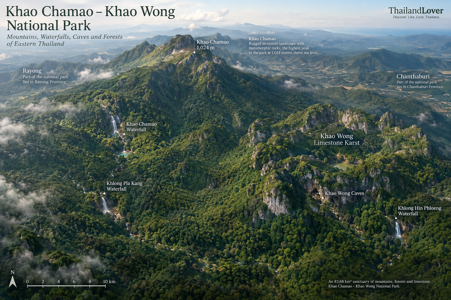
Khao Chamao is a high, rugged mountain landscape dominated by metamorphic rock, while Khao Wong is a striking limestone mountain complex shaped into a natural ring, with caves hidden within it.
Together, they form one of eastern Thailand’s more distinctive protected landscapes — a place where water, forest, rock and geology can all be experienced within the same national park.
This mountain-and-cave landscape is a standout destination in ThailandLover’s Nature & Parks collection.
You can walk beside a clear forest stream in one part of the park and explore a limestone cave system in another.
At a Glance
- Official Name
- Khao Chamao–Khao Wong National Park
- Thai Name
- อุทยานแห่งชาติเขาชะเมา–เขาวง
- Location
- Rayong and Chanthaburi Provinces
- Area
- Approximately 52,300 rai / 83.68 km²
- Established
- 31 December 1975
- National Park
- 13th national park of Thailand
- Highest Point
- Khao Chamao, approximately 1,024 m
- Landscape
- Mountain forest, streams, waterfalls and limestone formations
- Best Known For
- Khao Chamao Waterfall, Khlong Pla Kang and Khao Wong caves
- Main Experiences
- Waterfalls, forest walks, caves, viewpoints, photography
The park covers approximately 52,300 rai (83.68 square kilometres) and extends across Rayong and Chanthaburi. It was officially designated a national park on 31 December 1975.
Why Khao Chamao–Khao Wong Is Worth Discovering
Khao Chamao–Khao Wong is not simply a waterfall destination. Its real character comes from the relationship between mountains, forest and water.
The western and central mountain areas around Khao Chamao rise dramatically, with the highest summit reaching about 1,024 metres above sea level. The geology here is largely associated with metamorphic rocks, including gneiss and schist.
Further east, the landscape changes. The Khao Wong area is formed by a distinctive limestone mountain system. The mountains extend for roughly three kilometres and form a ring-like configuration around a lower central area. Over geological time, water has dissolved the limestone and created a karst landscape containing numerous caves.
This geological contrast is one of the park’s most interesting characteristics.
Khao Chamao: The Mountain
เขาชะเมา
The Khao Chamao section is the higher and more rugged side of the park. The mountain rises to approximately 1,024 metres above sea level, making it the highest point within the national park.
Its slopes are formed by a complex mountain landscape dominated by metamorphic rocks, including gneiss and schist. These geological formations contribute to the steep ridges and rugged character of the area.
The mountain is also important hydrologically. Several streams originate from the surrounding highlands, including waterways associated with Khlong Ra-Ok, Khlong Phlo and Khlong Hin Phloeng, which contribute to the wider Prasae River watershed — an important river system in Rayong.
Khao Wong: The Limestone World
เขาวง
If Khao Chamao represents the high mountain side of the park, Khao Wong represents its geological personality.
The Khao Wong mountain complex is made primarily of limestone and extends approximately three kilometres in a north–south direction. Its mountains form a distinctive ring-like configuration, surrounding a lower central area.
This is a classic karst landscape — a terrain created largely through the dissolution of soluble rock such as limestone by water over long periods of geological time. The result is a landscape of unusual rock formations, depressions, hidden passages and caves.
The central area of Khao Wong is notably lower and more humid than the surrounding limestone ridges, creating a very different ecological environment from the exposed mountain slopes.
Khao Chamao Waterfall
น้ำตกเขาชะเมา · น้ำตกคลองน้ำใส
Khao Chamao Waterfall, also known as Khlong Nam Sai Waterfall, is the best-known attraction within the national park — and the most accessible water experience.
Rather than being a single dramatic drop, it is better understood as a long sequence of pools, cascades and forest sections along a clear stream. The stream extends for approximately 3 kilometres, creating a series of distinctive natural sections along the route.
- Wang Nueng
- Wang Matcha
- Wang Morakot
- Wang Sai Ngam
- Pha Kluai Mai
- Chong Khaep
- Nam Tok Hok Sai
- Pha Sung
Wang Matcha
One of the most memorable sections is Wang Matcha. The pool is associated with large freshwater fish known locally as Pla Phluang, or mahseer-type fish. The fish have become part of the identity of the waterfall area, and visitors often stop here to observe them in the clear water.
This is one reason the Khao Chamao stream experience feels different from a conventional waterfall visit.
It is not only about watching water fall over rocks. It is about seeing how the forest, stream and aquatic ecosystem interact.
Khlong Pla Kang Waterfall
น้ำตกคลองปลาก้าง
For visitors looking for a more forest-oriented experience, Khlong Pla Kang Waterfall offers a different character. The waterfall system contains seven named sections, and the route extends for approximately 1.31 kilometres.
- Wang Chang Phan
- Lan Phi Suea
- Aeng Khruea Saba
- Lan Pratu Pha
- Than Ko Klang
- Wang Krachai
- Than Sai Mok
Instead of the more immediately accessible atmosphere around Khao Chamao Waterfall, the Khlong Pla Kang route provides a stronger sense of moving through forest. The surrounding vegetation includes ferns, understory plants and wild orchids.
This route is particularly interesting for visitors who enjoy nature observation and photography rather than simply swimming.
Khlong Hin Phloeng Waterfall
น้ำตกคลองหินเพลิง
Located on the Chanthaburi side of the park, Khlong Hin Phloeng Waterfall is a smaller waterfall system surrounded by evergreen forest.
It is less famous than Khao Chamao Waterfall, but that is precisely part of its appeal. The surrounding forest provides a quieter environment for observing vegetation, ferns and other moisture-loving plants.
Local tourism information describes the waterfall as having water flowing throughout the year, although actual water conditions naturally depend on rainfall and seasonal conditions.
Khao Wong Cave Complex
ถ้ำเขาวง
Perhaps the most unusual feature of the national park is the Khao Wong Cave Complex — a hidden world beneath the limestone.
The limestone mountains of Khao Wong contain a large number of caves formed through the long-term interaction between water and soluble limestone. Local park information records more than 80 caves, with around 16 caves traditionally opened for visitors.
Among the better-known caves are:
- Tham Phet (Diamond Cave)
- Tham Lakorn (Theatre Cave)
- Tham Singto (Lion Cave)
- Tham Khang Khao (Bat Cave)
- Tham Rong Bon
- Tham Tao (Turtle Cave)
The cave environment includes various limestone formations such as stalactites, stalagmites and other speleothems.
A note for visitors
Khao Wong should not be treated like an ordinary sightseeing cave. Cave exploration involves uneven surfaces, darkness, slippery rocks and potentially difficult passages.
Visitors should follow the park’s current access rules and use authorised guides or park staff where required. Cave access can also change depending on conservation, safety and seasonal conditions.
Pha Sawan Viewpoint
ผาสวรรค์
Pha Sawan provides a viewpoint experience rather than a waterfall or cave experience. The viewpoint is approximately 1.5 kilometres from the park headquarters.
According to local tourism information, visitors should contact park staff for a guide when accessing the route.
The attraction here is not a single iconic landmark. It is the opportunity to step away from the developed visitor area and experience the surrounding forest landscape from higher ground.
Forests & Plant Life
Khao Chamao–Khao Wong protects a mixture of tropical forest ecosystems. Forest surveys have identified tropical evergreen forest and dry evergreen forest as major vegetation types within the park.
The park’s plant communities include trees such as chingchan, padauk, makha mong, yang, agarwood and other native evergreen-forest species. The forest understory is also significant.
- Wild orchids
- Ferns
- Bamboo
- Rattan
- Ginger-family plants
- Other shade-loving understory vegetation
The exact species encountered will vary according to elevation, season, habitat and location within the park.
Wildlife
The park’s forests provide habitat for a range of wildlife and contribute to the wider forest landscape of eastern Thailand. Conservation importance is connected not only to individual animals, but also to the park’s role in that larger landscape.
Visitors should approach wildlife observation as an opportunity rather than an expectation. This is not a wildlife zoo. Animals may be present without being visible, and sightings depend on season, time of day, weather and human activity.
- Keep your distance
- Never feed animals
- Do not attempt to attract wildlife
- Keep noise to a minimum
- Stay on designated routes
- Never remove plants, rocks or other natural materials
The Importance of Water
Water is one of the defining elements of Khao Chamao–Khao Wong. The mountains function as important watershed areas for eastern Thailand. Streams originating in the forest feed into larger river systems, including the Prasae River system in Rayong.
This explains why waterfalls and clear streams are such a central part of the visitor experience.
Mountain → Forest → Stream → Waterfall → River
That relationship is one of the most important stories behind the park.
What to Do
Khao Chamao–Khao Wong is best experienced slowly.
- 1. Walk the waterfall trails
- Khao Chamao Waterfall is the obvious starting point. The sequence of pools and cascades provides numerous opportunities for photography, nature observation and — where officially permitted and safe — water-based recreation.
- 2. Explore the forest
- Look for ferns, orchids, large trees, forest textures, insects, birds and stream life even when there is no major attraction immediately in front of you.
- 3. Visit Khao Wong
- The limestone landscape makes it particularly interesting for visitors interested in geology and caves — a completely different experience from the waterfall area.
- 4. Explore caves with authorised guidance
- Cave exploration should be treated as a guided nature experience rather than independent adventure.
- 5. Photograph the landscape
- The park rewards landscape, long-exposure waterfall, macro, forest, wildlife and geological photography — rather than one single postcard view.
- 6. Camp and stay overnight
- The park has accommodation and camping facilities. Availability, booking arrangements and operating conditions should be checked with the park before travelling.
When to Visit
There is no single “best” month for everyone. It depends on what you want to see.
- Rainy season
- Generally the most dramatic water conditions: stronger streams, more powerful waterfalls and intensely green forest. Also the most photogenic period for water and vegetation — but rocks are slippery, water levels can change quickly, and temporary closures can apply. Water safety should always take priority over photographs.
- Cool season · November–February
- Generally more comfortable for walking, hiking, camping, photography and exploring the wider park. Waterfalls may not have the same volume as during the wet season, but the trails can be easier.
- Hot season
- The forest can still be attractive, but temperatures may make longer walks less comfortable. Waterfall areas can become particularly appealing because of shade and flowing water.
How to Get There
Khao Chamao–Khao Wong National Park is most conveniently reached by private car.
From Bangkok, one commonly used route is:
Bangkok → Motorway 7 → Ban Bueng → Highway 344 → Klaeng → Sukhumvit / Highway 3 → Ban Khao Din → park access road
Rayong provincial information places the park approximately 71 kilometres from Rayong city and describes the route via Sukhumvit Road around kilometre 274 before turning toward the park.
From Bangkok, allow sufficient travel time rather than treating the park as a quick half-day stop. It is much more enjoyable when combined with other destinations in eastern Thailand.
How Long Should You Stay?
- Half day
- Suitable if your main objective is Khao Chamao Waterfall — the simplest way to experience the park.
- Full day
- Better if you want to combine waterfall exploration, forest walking, photography, viewpoints and a more relaxed pace.
- Overnight
- Makes more sense for camping, early-morning photography, birdwatching, forest atmosphere and exploring more than one section of the park. Confirm accommodation and camping with the park before travelling.
Who Is Khao Chamao–Khao Wong For?
- Nature lovers
- A strong combination of forest, streams, waterfalls and limestone landscapes.
- Photographers
- Water, forest, rock formations and caves create a wide variety of subjects.
- Families
- The more accessible waterfall area can work well for a family nature outing, provided water safety and trail conditions are taken seriously.
- Hikers and outdoor travellers
- There are opportunities to walk beyond the main visitor area and explore forest environments.
- Geology enthusiasts
- The contrast between the metamorphic mountain of Khao Chamao and the limestone karst of Khao Wong is particularly interesting.
- Travellers looking beyond the beach
- For anyone visiting Rayong who wants a completely different side of the province, this is one of the strongest choices.
Who may want to skip it
Khao Chamao–Khao Wong may not be the ideal choice if your idea of a Thailand holiday is luxury resorts, cafés and shopping, easy roadside sightseeing, zero walking or highly developed attractions.
This is fundamentally a nature destination. The reward comes from being outside, walking through forest and following water into the landscape.
Responsible Travel
Khao Chamao–Khao Wong is a protected natural environment. The most important rule is simple: leave the forest as you found it.
- Do not leave plastic or food waste
- Do not feed fish or wildlife unless explicitly permitted by park authorities
- Do not collect plants, flowers, rocks or cave formations
- Do not write on rocks or cave walls
- Do not play loud music
- Do not enter restricted areas
- Do not swim where park authorities prohibit swimming
- Do not ignore temporary warnings or closures
In caves, never touch formations unnecessarily. A cave can take thousands of years — sometimes far longer — to create a formation that can be damaged in seconds.
Practical Information
- Park
- Khao Chamao–Khao Wong National Park
- Thai
- อุทยานแห่งชาติเขาชะเมา–เขาวง
- Provinces
- Rayong and Chanthaburi
- Area
- Approximately 52,300 rai / 83.68 km²
- Established
- 31 December 1975
- Highest Mountain
- Khao Chamao, approximately 1,024 m
- Main Waterfall
- Khao Chamao / Khlong Nam Sai
- Other Waterfalls
- Khlong Pla Kang and Khlong Hin Phloeng
- Cave System
- Khao Wong
- Main Activities
- Nature walks, waterfalls, caves, photography, birdwatching, camping
The ThailandLover Experience
If you have only a few hours, go to Khao Chamao Waterfall.
If you have a full day, slow down and explore beyond the main waterfall.
If you are interested in geology, make Khao Wong a priority.
If you love photography, come prepared for water, forest, rock and details rather than looking for one single postcard view.
And if you want to understand eastern Thailand beyond its beaches, spend time in the forest.
The real story of Khao Chamao–Khao Wong is not one attraction. It is the relationship between mountain, forest, water and stone.
Quick Guide
- Best For
- Nature · Waterfalls · Forest · Caves · Photography · Hiking · Geology
- Signature Experience
- Following the clear stream through Khao Chamao Waterfall
- Most Distinctive Feature
- Metamorphic mountains of Khao Chamao and limestone karst of Khao Wong
- Don’t Miss
- Wang Matcha · Khlong Pla Kang · Khao Wong caves · Pha Sawan
- Recommended Time
- Half day for the main waterfall; one full day for a deeper visit
- Best Approach
- Come early, take your time, and treat the park as a landscape rather than a checklist
Frequently Asked Questions
- What is Khao Chamao–Khao Wong National Park?
- Khao Chamao–Khao Wong National Park, or อุทยานแห่งชาติเขาชะเมา–เขาวง, is Thailand’s 13th national park, established on 31 December 1975. It covers about 83.68 km² of mountain forest, streams, waterfalls and limestone caves in Rayong and Chanthaburi.
- Where is the park?
- In eastern Thailand, covering parts of Rayong and Chanthaburi. Districts include Klaeng and Khao Chamao in Rayong, and Kaeng Hang Maeo in Chanthaburi. Rayong provincial information places it about 71 kilometres from Rayong city.
- What is the difference between Khao Chamao and Khao Wong?
- Khao Chamao is the high, rugged mountain side, rising to about 1,024 metres and formed largely of metamorphic rock. Khao Wong is a limestone karst complex about three kilometres long, with a ring-like mountain shape and numerous caves.
- What waterfalls can you visit?
- Khao Chamao Waterfall, also called Khlong Nam Sai, is a roughly 3 km sequence of pools including Wang Matcha. Khlong Pla Kang has seven named sections along about 1.31 km. Khlong Hin Phloeng is a quieter waterfall on the Chanthaburi side.
- Can you visit the Khao Wong caves?
- Local park information records more than 80 caves, with around 16 traditionally opened to visitors. Access can change for conservation and safety. Follow current park rules and use authorised guides or park staff where required.
- When is the best time to visit?
- The rainy season is generally strongest for waterfalls and green forest, but rocks can be slippery. November–February is usually more comfortable for walking and camping. The best month depends on whether you want water volume or easier trails.
- How do I get there?
- A private car is the most practical option. From Bangkok, a common route is Motorway 7 → Ban Bueng → Highway 344 → Klaeng → Sukhumvit / Highway 3 → Ban Khao Din → the park access road. Rayong information describes the turn near Sukhumvit kilometre 274.
- How do I contact the park?
- Published contacts include 0 3802 0510 (VoIP) and 0 3889 4378. Confirm opening status, cave access, camping, fees and current conditions before travelling.
Related Destinations
- Khao Khitchakut National Park
- Another forested mountain landscape in Chanthaburi, known for pilgrimage routes and eastern forest scenery.
- Namtok Phlio National Park
- A Chanthaburi waterfall park with clear pools and forest — a natural companion to a Khao Chamao journey.
- Khao Laem Ya–Mu Ko Samet
- Rayong’s coastal protected landscape — islands and sea, the other side of the province from Khao Chamao’s mountains.
- Nature & Parks
- More protected landscapes across ThailandLover’s national-park collection.
Location
Find Khao Chamao–Khao Wong National Park
Nam Pen, Khao Chamao, Rayong 21110