



National Park · Chanthaburi
Namtok Phlio National Park
อุทยานแห่งชาติน้ำตกพลิ้ว
Where Clear Mountain Water Meets a Royal Story
Chanthaburi, Eastern Thailand
Some waterfalls are remembered for their height. Others for their power. Namtok Phlio is remembered for something more unusual — the water, the forest, the fish, and the story that surrounds them.
Nature and Royal History in One Landscape
Hidden in the green mountains of eastern Thailand, Namtok Phlio National Park protects a compact but remarkably diverse landscape of rainforest, mountain streams, waterfalls and historical monuments.
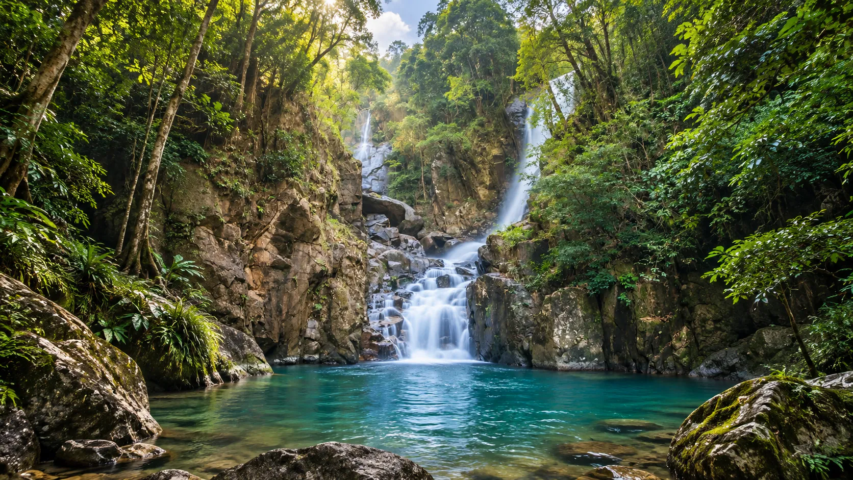
Its best-known attraction is Phlio Waterfall, where clear mountain water pours into a natural pool inhabited by large schools of stone-sucking carp, known locally as pla phluang hin.
But there is another layer. In the nineteenth century, King Chulalongkorn, Rama V, visited the waterfall with Queen Sunandha Kumariratana and became deeply impressed by its scenery. A laterite chedi still stands near the falls. Nearby, a pyramid-shaped memorial preserves the memory of Queen Sunandha.
You can walk through rainforest, stand beside a waterfall, watch fish moving through crystal-clear water, and then encounter nineteenth-century monuments within minutes. That combination is what makes Namtok Phlio special.
Nature and royal history occupy the same landscape.
At a Glance
- 11th
- National park of Thailand. Established 2 May 1975 as Khao Sa Bap; renamed 1982.
- 134.50 km²
- Approximately 84,062.5 rai across the Khao Sa Bap mountains.
- Phlio Falls
- Clear pools, rainforest and schools of stone-sucking carp.
- Royal story
- Alongkorn Chedi (1876) and Sunandha Memorial Pyramid (1881).
- Official English name
- Namtok Phlio National Park
- Thai name
- อุทยานแห่งชาติน้ำตกพลิ้ว
- Province
- Chanthaburi
- Districts covered
- Mueang Chanthaburi, Laem Sing, Khlung and Makham
- Area
- Approximately 134.50 km² / 84,062.5 rai
- Mountain range
- Khao Sa Bap Range
- Elevation
- Approximately 20–924 m above sea level
- Highest point
- Map Wa Krok / Maph Wā Krok area, approximately 924 m
- National park status
- Established 2 May 1975 · 11th national park of Thailand
- Original name
- Khao Sa Bap National Park
- Name change
- 29 September 1982 → Namtok Phlio National Park
- Signature attraction
- Phlio Waterfall
- Wildlife highlight
- Stone-sucking carp / Soro brook carp (pla phluang hin)
- Historical highlights
- Alongkorn Chedi · Sunandha Memorial Pyramid
- Other waterfalls
- Khlong Narai, Trok Nong, Makok and smaller cascades
- Other attractions
- Huai Ta Bo Reservoir, forest trails and streams
DNP’s current national-park information confirms that Namtok Phlio covers parts of Mueang Chanthaburi, Laem Sing, Khlung and Makham districts. The commonly cited park area is approximately 134.50 square kilometres, or about 84,062.5 rai.

Where Is Namtok Phlio?
Namtok Phlio National Park is located in Chanthaburi Province in eastern Thailand. The principal waterfall area lies in Phlio Subdistrict, Laem Sing District, approximately 14–15 kilometres from Chanthaburi city.
The park extends beyond the immediate waterfall area into a larger mountainous landscape covering parts of Mueang Chanthaburi, Laem Sing, Khlung and Makham. The waterfall most visitors see represents only a small, accessible portion of the protected landscape. The surrounding mountains contain forests, streams and additional waterfalls that require more time to explore.
TAT identifies Phlio Waterfall as one of Chanthaburi’s major natural attractions and places it among the province’s principal destinations.
The Khao Sa Bap Mountains
The park is centred on the Khao Sa Bap mountain range. This is an important detail because Namtok Phlio is not simply a waterfall surrounded by trees — it is a mountain watershed.
The terrain rises from approximately 20 metres above sea level to around 924 metres at its highest point. Elevation changes create different forest conditions and allow numerous streams to descend from the mountains. The highest point traditionally identified within the park is the Map Wa Krok area, approximately 924 metres above sea level.
A small park with a big landscape
At approximately 134.5 km², Namtok Phlio is not one of Thailand’s enormous national parks. Its importance comes from something else: a compact protected mountain landscape located close to a major provincial city.
Unusually accessible
Visitors can leave Chanthaburi’s urban environment and reach rainforest and mountain streams within a short drive — one reason the park matters to local residents as well as travellers.
The Story of Phlio Waterfall
The waterfall that became a destination
Phlio Waterfall is the heart of the national park. It is not an enormous vertical waterfall. Instead, its appeal comes from the combination of clear water + rock + rainforest + fish + accessibility.
The waterfall is formed by mountain streams descending over rock before collecting in clear natural pools. The water continues through the forest downstream. TAT describes Phlio as a three-level waterfall with a clear pool and identifies the fish-filled stream as one of its distinctive attractions.
The water is not simply rushing past you. It is transparent.
Clear Water, Living Water
One of the first things visitors notice is the clarity of the water. The natural pools are sufficiently clear that the rocky and sandy bottom can often be seen beneath the surface.
This clarity is one of the reasons Phlio Waterfall has become famous for its fish. It also creates a visual effect that makes the waterfall feel calmer than many larger Thai waterfalls. You can see the landscape continuing beneath the surface.
The Stone-Sucking Carp
The fish that made Phlio famous
One of Namtok Phlio’s most distinctive natural features is its population of large freshwater fish. They are commonly known in Thai as Pla Phluang Hin — ปลาพลวงหิน and are generally referred to in English as stone-sucking carp or Soro brook carp.
The fish belong to the mahseer group of freshwater cyprinids. They live in clear mountain streams and pools, particularly around rocky riverbeds. At Phlio Waterfall, large numbers can gather in the clear water. DNP has described the waterfall as having streams filled with tens of thousands of stone-sucking carp, highlighting them as one of the site’s defining natural features.
Why are there so many fish?
- Clear flowing water
- Rocky riverbeds and pools
- Forest shade
- Continuous water flow
- Natural food sources
The forest surrounding the stream helps maintain water quality by protecting the watershed. The fish are not a separate attraction — they are part of the river ecosystem.
A Rainforest Waterfall
The waterfall is surrounded by humid forest. Trees provide shade along the stream, creating a cooler microclimate than the open agricultural and urban areas outside the park. The forest also helps regulate water — rainfall is absorbed into the mountain environment before emerging through streams and flowing toward the falls.
Forest → water → waterfall → fish
Namtok Phlio contains humid tropical forest environments associated with the Khao Sa Bap mountains. Botanical surveys have recorded dipterocarps, evergreen forest trees, fruiting trees, vines, ferns and other tropical vegetation. Vegetation varies with elevation and moisture: lower visitor areas are relatively accessible; higher mountain areas become increasingly forested and rugged.
Biodiversity Beyond the Waterfall
Namtok Phlio’s forests form part of the Thai portion of the Cardamom Mountains landscape, with the Khao Sa Bap massif representing an isolated western extension associated with the larger Cardamom system.
A scientific study of reptiles in the park noted that Namtok Phlio preserves an isolated forest fragment associated with the Cardamom Mountains and documented the Annam kukri snake (Oligodon annamensis) in the park — a significant extension of the known distribution of that species in Thailand.
The park is therefore more than a recreational waterfall. It is also a small but biologically important forest island.
Birds & Forest Wildlife
Visitors who spend time away from the busiest waterfall area may encounter a variety of forest birds and smaller wildlife. Historical records and field observations associated with the Khao Sa Bap landscape include species such as:
- Siamese fireback
- Silver pheasant
- Chestnut-headed partridge
- Blue-rumped pitta
- Various babblers, barbets, sunbirds and forest flycatchers
These species should not be interpreted as guaranteed sightings. Bird populations move according to season, food availability, weather and disturbance. The best approach is to enter the forest quietly and allow wildlife to appear naturally.
The Royal Connection
When nature became part of history
Namtok Phlio is unusual among Thai national parks because its landscape is closely associated with the history of King Chulalongkorn, Rama V, and Queen Sunandha Kumariratana.
Historical sources agree that the royal couple visited Phlio Waterfall during the 1870s and that the King was deeply impressed by the landscape. There is, however, a discrepancy among official sources concerning the exact year of the first visit:
- DNP’s 2026 historical account gives B.E. 2416 / 1873.
- ONEP’s cultural-heritage record and TAT’s English material give B.E. 2417 / 1874.
For historical accuracy, ThailandLover avoids presenting one of these conflicting dates as uncontested fact.
A surviving account records Rama V’s comparison of Phlio with other waterfalls he had visited, including Penang, Ko Chang and Si Phaya — essentially that he had not seen another waterfall more beautiful than Phlio, and that he could happily sit there until evening because of the cool and refreshing atmosphere. The waterfall was not merely visited. It was remembered.
Alongkorn Chedi
A monument beside the waterfall · 1876
Alongkorn Chedi was constructed from laterite in 1876. It commemorates the royal visit to Phlio Waterfall. The monument stands on elevated ground close to the waterfall and remains surrounded by forest. Over time, the humid environment has covered portions of the laterite surface with moss and vegetation.
A nineteenth-century monument embedded within a living rainforest.
The chedi is not simply an old monument. It provides physical evidence of the historical relationship between the royal court and the landscape. Today, visitors can experience both the natural landscape and the historical structure within the same short walk. That is rare.
Sunandha Memorial Pyramid
Phra Nang Ruea Lom Pyramid · 1881
A short distance from the waterfall stands another remarkable structure: the Sunandha Memorial, also commonly called Phra Nang Ruea Lom Pyramid or Pyramid of Phra Nang Ruea Lom.
It is a pyramid-shaped memorial constructed in 1881, during the reign of Rama V. The monument commemorates Queen Sunandha Kumariratana, who died in a royal barge accident on the Chao Phraya River. Part of her ashes was placed within the memorial.
Why a pyramid?
According to the historical account preserved by ONEP and DNP, Rama V wanted the memorial to endure in a remote forest environment. The pyramid form was chosen with the durability of the Egyptian pyramids in mind — a memorial designed to outlast time. The monument was officially named Sunandha Memorial — Sunandhanusawari.
Alongkorn Chedi
Represents a joyful royal association with the landscape.
Sunandha Memorial
Represents remembrance and grief. Together they create a very different interpretation of the waterfall.
Phlio is not simply a place where people come to swim. It is a landscape where nature became intertwined with one of the better-known personal stories of Thailand’s nineteenth-century monarchy.
Ang Sarn, Ang Song & Phra Narai Cave
- Ang Sarn
- A former pavilion near the stream, reportedly from the reign of Rama IV. Erosion and stream force destroyed it in 1974 — now part of the landscape’s memory rather than an intact attraction.
- Ang Song / Ang Hong
- A small stream and pool associated with a rock formation resembling a swan’s tail, historically connected with bathing activities of Rama IV and Rama V.
- Phra Narai Cave
- Traditionally associated with a natural water source; historical tourism information describes a cave approximately one kilometre long with water still emerging. Access conditions should be checked with park staff.
Water preserves some things. And destroys others.
Beyond Phlio: Other Waterfalls
Namtok Trok Nong
A deeper forest waterfall experience, traditionally described with three principal levels: Namtok Mai Si (bamboo tunnel ~50 m), Namtok Klang (middle forest section), and Namtok Trok Nong (upper cliff fall of ~20 m). Contact park staff before attempting the upper route.
Namtok Khlong Narai
Also known in some sources as Namtok Khao Sa Bap. Farther from the main visitor area; TAT describes a waterfall approximately 25 metres high, reached through a more natural forest environment. Phlio is accessible and highly visited; Khlong Narai feels more like a forest excursion.
Namtok Makok lies farther from the main tourist centre and is part of the park’s network of forest streams and waterfalls. Multiple waterfalls demonstrate that the park protects an entire mountain drainage system — not simply one scenic feature.
Huai Ta Bo Reservoir
A quieter side of Namtok Phlio
One of the more recent visitor attractions within the park is Huai Ta Bo Reservoir. Surrounded by forest, it provides a much calmer landscape than the busy waterfall area — suited to walking, photography, picnicking, relaxing, camping and early-morning scenery.
DNP’s February 2026 information describes the area as open daily from 08:00 to 16:30, with ticket sales ending at 16:00. Early morning mist over the reservoir is highlighted as a particularly attractive time to visit.
Camping
Visitors bringing their own tent pay approximately THB 30 per person per night; rental tents are also available. At the time of DNP’s 2026 notice, camping was operated on a walk-in basis — arrive early, particularly during long weekends. Verify the current system before travelling.
Still water + forest + sky
Instead of the sound of a waterfall, the dominant experience is calm reflection. Early mist; later forest mirrored in the water. For photographers, this is one of the more understated locations within the park.
Nature Trails
The most accessible trails around the main park area introduce visitors to tropical forest structure, streams, plants, rocks, wildlife habitat and watershed ecology.
Historical TAT information describes a 1,200-metre ecological study trail near the national-park headquarters, taking approximately 45 minutes under normal conditions. Other routes extend farther into the forest. Trail conditions can change with rainfall and maintenance — current information from park staff should take priority over historical distances.
The Meaning of “Phlio”
The origin of the name Phlio is not entirely settled in published tourism sources. One commonly repeated explanation connects it with the language of the Chong people, an Indigenous group historically associated with the Chanthaburi region, with a meaning related to sand or sandy ground. Another explanation links the name to a local plant associated with sandy soil.
Because published sources differ on the precise etymology, ThailandLover presents this as a traditional/local explanation rather than an established linguistic fact. The Chong are part of the cultural geography surrounding Chanthaburi — the name Phlio belongs to a landscape with a much older cultural history than the national park itself.
Climate & Best Time to Visit
Namtok Phlio lies in a humid part of eastern Thailand. Rainfall is an important part of the area’s ecology. Phlio’s streams are known for maintaining water through much of the year, but the character of the waterfall changes with rainfall.
- May – October
- Best for water. Stronger streams, greener forest, fuller cascades — also slippery surfaces and rapidly changing conditions.
- November – February
- Comfortable for exploring. Cooler walking weather; good for combining waterfall, history and other Chanthaburi attractions.
- March – April
- Hotter, but still green. Flow varies with rainfall; early mornings help avoid the strongest heat.
Maximum water flow
Rainy season — and check recent conditions before you go.
Comfortable walking
Cooler months. For lush rainforest photography, visit shortly after rain.
How to Get There
From Chanthaburi city, follow Sukhumvit Road / Highway 3 toward the east. The park entrance is approximately 14–15 kilometres from the city area. Historical tourism information places the turn toward the waterfall around the 347-kilometre marker on Highway 3, followed by a short drive to the park.
The main road is paved and the waterfall area is relatively accessible — one reason Namtok Phlio suits travellers who want a nature experience without committing to a remote mountain journey.
From Bangkok
The most straightforward route is generally Bangkok → Chon Buri → Rayong → Chanthaburi, then continue toward the Phlio area along Highway 3. Allow extra time during weekends and holidays.
How Long Should You Spend?
- Quick visit
- 1.5–2 hours — waterfall, fish, Alongkorn Chedi and Sunandha Memorial.
- Half day
- 3–5 hours — forest walks, time beside the water, monuments and photography without rushing.
- Full day
- Combine Phlio Waterfall, Huai Ta Bo, a nature trail, another waterfall and Chanthaburi town.
A good ThailandLover day
- Morning — Namtok Phlio Waterfall. Arrive early for softer light and cooler air.
- Late morning — Alongkorn Chedi + Sunandha Memorial. Take time with the history.
- Afternoon — Huai Ta Bo Reservoir. Slow down, walk, photograph the forest.
- Evening — Return to Chanthaburi for old town, food or the waterfront.
Swimming & Water Safety
The clear pools around Phlio are historically known as places where visitors can enter the water. However, this is a natural mountain stream. Conditions can change rapidly after heavy rain. Current park rules, designated swimming areas and safety warnings must always take priority.
The fish may swim around people in the water — part of the natural experience. Avoid grabbing, chasing or otherwise disturbing them.
- Watch your footing on wet rocks
- Do not enter strong currents
- Do not swim after heavy rainfall if officials advise against it
- Keep children within sight
- Do not climb unstable rocks
- Follow signs, barriers and temporary closures
Facilities, Fees & Hours
The main visitor area has parking, toilets, visitor information, food and refreshment areas, walking routes, viewing areas and camping facilities in designated locations. Facilities differ between the main waterfall area and remote ranger stations.
- Park fee group
- DNP National Park Group 2
- Thai visitors
- Adult THB 40 · Child THB 20
- Foreign visitors
- Adult THB 200 · Child THB 100
- Vehicles
- 4-wheel THB 30 · Motorcycle THB 20
- Huai Ta Bo hours (Feb 2026 DNP)
- 08:00–16:30 daily · ticket sales end 16:00
- Camping (own tent)
- Approx. THB 30 per person per night at Huai Ta Bo · verify current system
These are DNP’s published rates and hours at the time of writing. Fees, opening arrangements and camping policies can change — confirm before travel.
What to bring
- Comfortable walking shoes — forest paths can be wet and slippery
- Swimwear only if swimming is currently permitted
- Towel, drinking water and insect repellent
- Rain protection in the wet season
- Dry bag for phone and camera
- Binoculars for birdwatching
Photography & Wildlife Etiquette
Namtok Phlio is a versatile photography destination: waterfall rocks and vegetation as foreground, fish through clear water, forest layers and filtered light, moss-covered monuments, and early mist at Huai Ta Bo.
- Do not capture animals or remove wildlife
- Do not collect plants or damage rocks
- Do not disturb nests
- Do not play loud music
- Do not leave food waste or plastic in the forest
The park’s greatest attraction is a living ecosystem. Keep it alive.
Conservation
Namtok Phlio protects more than scenery. The forest protects water. The streams support aquatic life. The mountains provide habitat. The vegetation stabilises slopes and contributes to watershed function. And the protected landscape preserves historical monuments that would be much harder to maintain without the surrounding forest.
A natural heritage site — and a cultural heritage landscape.
The Park’s Historical Timeline
- 1870s
- King Chulalongkorn and Queen Sunandha visit Phlio Waterfall. Official sources differ on 1873 vs 1874.
- 1876
- Alongkorn Chedi constructed from laterite.
- 1880–1881
- Queen Sunandha dies in a Chao Phraya barge accident (1880). Sunandha Memorial Pyramid built at Phlio (1881).
- 1975
- Established as Khao Sa Bap National Park — Thailand’s 11th national park.
- 1982
- Renamed Namtok Phlio National Park (approved 29 September 1982).
- 2026
- DNP continues to promote the park as both a natural and historical destination.
The park was originally named for the mountain range. Later, the name changed because Phlio Waterfall had become the area’s most recognisable natural attraction. Older scientific and travel literature may still refer to Khao Sa Bap National Park when describing what is now Namtok Phlio.
Namtok Phlio & Chanthaburi
The park works particularly well as part of a broader Chanthaburi itinerary — rainforest, waterfalls, fruit orchards, historic architecture, gem trading, Catholic heritage, coastal landscapes, fishing communities and local food. Namtok Phlio adds the natural and historical dimension.
TAT includes Namtok Phlio in its recommended two-day Chanthaburi itinerary alongside attractions such as Khao Laem Sing, Laem Sing Beach, Wat Mangkon Buppharam and Khuk Khi Kai.
Not just a waterfall. Not just a historical monument. A place where the two overlap.
Is Namtok Phlio Worth Visiting?
For travellers looking for a combination of nature + swimming + wildlife + history + easy access, Namtok Phlio is particularly distinctive. It is also one of the better national parks for visitors who do not want a demanding multi-hour mountain trek. The main attraction is close to visitor facilities; the historical monuments are nearby; and the fish-filled pools provide an immediate connection with the natural environment.
Best for
Nature lovers, families (with water safety), photographers, history lovers, birdwatchers, slow travellers and anyone visiting Chanthaburi.
Plan more carefully if
You are visiting during heavy rain, seeking remote wilderness (weekends can be busy), expecting a serious hike only at the main falls, or wanting a completely untouched environment — the main site is an established tourism destination.
Essential Information
- Official name
- Namtok Phlio National Park
- Thai
- อุทยานแห่งชาติน้ำตกพลิ้ว
- Province
- Chanthaburi
- Districts
- Mueang Chanthaburi, Laem Sing, Khlung and Makham
- Area
- Approximately 134.50 km² / 84,062.5 rai
- Mountain range
- Khao Sa Bap
- Elevation
- Approximately 20–924 m
- Highest point
- Map Wa Krok area, approximately 924 m
- Established
- 2 May 1975 · National park no. 11
- Original name
- Khao Sa Bap National Park
- Renamed
- Namtok Phlio National Park, 1982
- Main attraction
- Phlio Waterfall
- Signature wildlife
- Stone-sucking carp / Soro brook carp
- Historical monuments
- Alongkorn Chedi · Sunandha Memorial Pyramid
- Other attractions
- Khlong Narai, Trok Nong, Makok, Huai Ta Bo Reservoir, forest trails
- Nearest city
- Chanthaburi · approx. 14–15 km
- Main road
- Highway 3 / Sukhumvit Road
Frequently Asked Questions
- Where is Namtok Phlio National Park?
- In Chanthaburi Province, eastern Thailand, covering parts of Mueang Chanthaburi, Laem Sing, Khlung and Makham.
- How far is Namtok Phlio from Chanthaburi city?
- The main waterfall area is approximately 14–15 kilometres from Chanthaburi city.
- What is Namtok Phlio famous for?
- Phlio Waterfall, clear stream pools, large schools of stone-sucking carp, and two royal-era monuments: Alongkorn Chedi and the Sunandha Memorial Pyramid.
- Can I swim at Phlio Waterfall?
- Swimming has traditionally been permitted in designated pools, but conditions and regulations can change. Always follow current park staff instructions, especially after heavy rain.
- What are the fish in Phlio Waterfall?
- Stone-sucking carp or Soro brook carp, locally pla phluang hin — freshwater fish of clear mountain streams, present in very large numbers according to DNP.
- What is Alongkorn Chedi?
- A laterite chedi constructed in 1876 in connection with the royal visits of Rama V and Queen Sunandha Kumariratana.
- What is the pyramid near Phlio Waterfall?
- The Sunandha Memorial (Phra Nang Ruea Lom Pyramid), built in 1881; part of Queen Sunandha’s ashes was placed inside.
- Did Rama V visit Phlio Waterfall?
- Yes. Sources agree on the visit and his admiration; they differ on whether the relevant year is 1873 or 1874.
- When was the park established?
- As Khao Sa Bap National Park on 2 May 1975 (11th national park); renamed Namtok Phlio in 1982.
- How large is the national park?
- Approximately 134.50 km² / 84,062.5 rai.
- Are there other waterfalls?
- Yes — Khlong Narai, Trok Nong and Makok, among other streams and cascades.
- Can I camp there?
- Yes, at designated areas. DNP’s February 2026 information specifically identifies Huai Ta Bo as a camping location.
- What is Huai Ta Bo?
- A forest-surrounded reservoir within the park — walking, photography, picnicking and camping, especially atmospheric in early morning mist.
- How much is the entrance fee?
- Group 2 rates: Thai adults THB 40 / children THB 20; foreign adults THB 200 / children THB 100. Vehicle fees are separate.
More Eastern Thailand Nature
- Khao Khitchakut National Park
- Sacred mountain pilgrimages and forest landscape in Chanthaburi.
- Khao Chamao–Khao Wong National Park
- Waterfalls and wildlife corridors across Rayong and Chanthaburi.
- Khao Sip Ha Chan National Park
- Eastern Forest Complex hills linking several Chanthaburi protected areas.
- Namtok Khlong Kaeo National Park
- Another eastern waterfall park in the wider Chanthaburi landscape.
- Khao Laem Ya–Mu Ko Samet
- Coastal and island nature on the Rayong side of the east coast.
- All Nature & Parks
- Browse ThailandLover’s national park guides across the country.
Location
Find Namtok Phlio
Highway 3 / Sukhumvit Road · Phlio, Laem Sing, Chanthaburi — about 14–15 km from Chanthaburi city