

National Park · Chanthaburi
Khao Khitchakut National Park
อุทยานแห่งชาติเขาคิชฌกูฏ
Where Forest, Granite Mountains and Faith Meet
Chanthaburi · Eastern Thailand
Steep granite, tropical forest and a living pilgrimage — a compact Chanthaburi mountain where nature and faith occupy the same landscape.
Where Forest, Granite Mountains and Faith Meet
There are mountains in Thailand that people climb for the view. And there are mountains they climb for something more.
Khao Khitchakut National Park is both.
Rising above the forested landscape of Chanthaburi, this compact national park combines steep granite mountains, tropical forest, waterfalls and important headwaters with one of Thailand’s most revered pilgrimage sites: Phra Bat Khao Khitchakut, or Phra Bat Phluang — the sacred Buddha’s Footprint on the mountain.
The experience is unusual. One moment, the landscape is entirely natural: dense forest, granite outcrops, streams and waterfalls. Then, higher on the mountain, the character changes. A pilgrimage route winds toward a sacred landscape of enormous weathered rocks, shrines and the revered footprint.
This granite-and-faith landscape is a standout destination in ThailandLover’s Nature & Parks collection.
This is not simply a mountain destination. It is a place where nature and faith have occupied the same landscape for generations.
Khao Khitchakut at a Glance
- Official Name
- Khao Khitchakut National Park
- Thai Name
- อุทยานแห่งชาติเขาคิชฌกูฏ
- Province
- Chanthaburi
- Districts
- Makham and Khao Khitchakut
- Area
- Approximately 58.31 km² / 36,444.05 rai
- Established
- 4 May 1977
- National Park
- 14th national park of Thailand
- Highest Mountain
- Khao Phra Bat / Khao Khitchakut, approximately 1,085 m
- Sacred Site
- Phra Bat Khao Khitchakut / Phra Bat Phluang
- Footprint Elevation
- More than 1,050 m above sea level
- Main Waterfall
- Krathing Waterfall (13 levels)
- Other Waterfalls
- Khlong Chang Sao, Khlong Phai Boun, Khlong Krasiu
- Major Ecosystems
- Tropical evergreen forest and montane forest
- Watershed
- Chanthaburi River headwaters
The park originally covered 36,687 rai (58.70 km²). After a later boundary adjustment removing 242.95 rai, the remaining area is approximately 36,444.05 rai, or 58.31 km². It was officially established as Thailand’s 14th national park on 4 May 1977.
Why Khao Khitchakut Is Different
Khao Khitchakut does not have the enormous geographic scale of some of Thailand’s better-known national parks. Its importance lies elsewhere.
Within a relatively compact area, the park brings together high granite mountains, dense tropical forest, waterfalls and headwaters, distinctive granite boulders, wildlife habitat, panoramic mountain views — and a major Buddhist pilgrimage landscape.
The mountain is simultaneously a protected natural landscape and a deeply meaningful cultural landscape.
Khao Phra Bat — The High Point of the Park
เขาพระบาท
The park’s mountain terrain is steep and rugged. The underlying geology is predominantly granite, associated with Jurassic-age igneous rocks. Geological information provided by local authorities places these rocks at approximately 135–180 million years old.
The mountain ridge generally runs from northwest to southeast, with particularly steep terrain toward the eastern side. The highest summit is known as Khao Phra Bat, reaching approximately 1,085 metres above mean sea level according to environmental and local-government sources.
This is important because another figure frequently appears in tourism information: 1,050 metres. That number refers specifically to the elevation of the Buddha’s Footprint site, rather than necessarily representing the absolute highest point of the mountain.
The distinction matters when presenting the information accurately.
Granite: The Character of Khao Khitchakut
Unlike limestone landscapes where caves and sharp karst towers dominate, Khao Khitchakut is fundamentally a granite mountain landscape.
Large rounded granite boulders are scattered across the upper mountain. Some are enormous. Their weathered surfaces and unusual shapes have become part of the visual identity of the mountain and, over generations, have become incorporated into local religious stories and interpretations.
The sacred landscape is therefore not an artificial religious complex placed onto an otherwise ordinary mountain. The religious experience is intertwined with the mountain’s natural geology.
Phra Bat Khao Khitchakut
พระบาทเขาคิชฌกูฏ · พระบาทพลวง
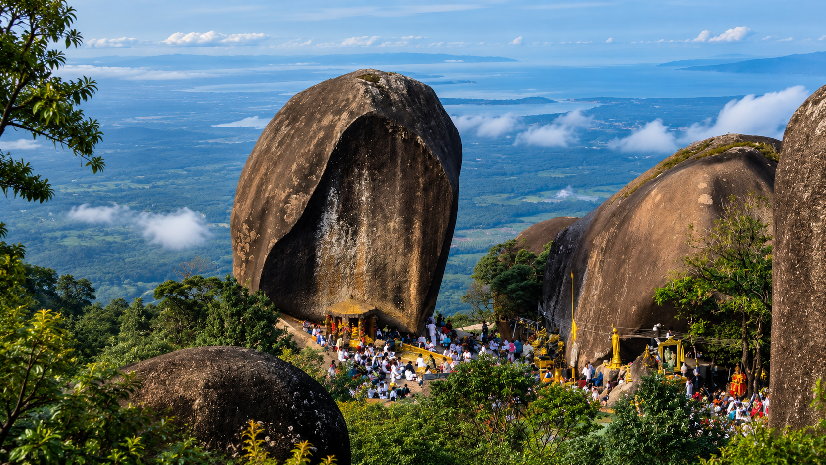
The defining attraction of Khao Khitchakut is Phra Bat Khao Khitchakut, also widely known as Phra Bat Phluang. The site is regarded as one of Thailand’s most important Buddhist pilgrimage destinations.
The Buddha’s Footprint is located at an elevation of more than 1,050 metres above sea level, making it widely described by the Department of National Parks as the highest Buddha’s Footprint in Thailand.
The footprint is carved naturally into a large rock surface. DNP describes it as approximately 2 metres or more in depth, 1 metre wide and 2 metres long.
A sacred landscape of stone
The area surrounding the footprint contains numerous unusual granite formations. Among the traditional names associated with the summit landscape are:
- The Upside-Down Alms Bowl Rock
- Sila Chedi
- Hermit’s Cave
- Phra Indra’s Racetrack
- Turtle-shaped Rock
- Giant Elephant-shaped Rock
- Hin Thoen — the Balancing Rock
These names are part of the cultural interpretation of the landscape rather than geological classifications. The physical rocks themselves are products of the mountain’s natural geological processes; their religious and legendary identities were subsequently attached to them through local traditions.
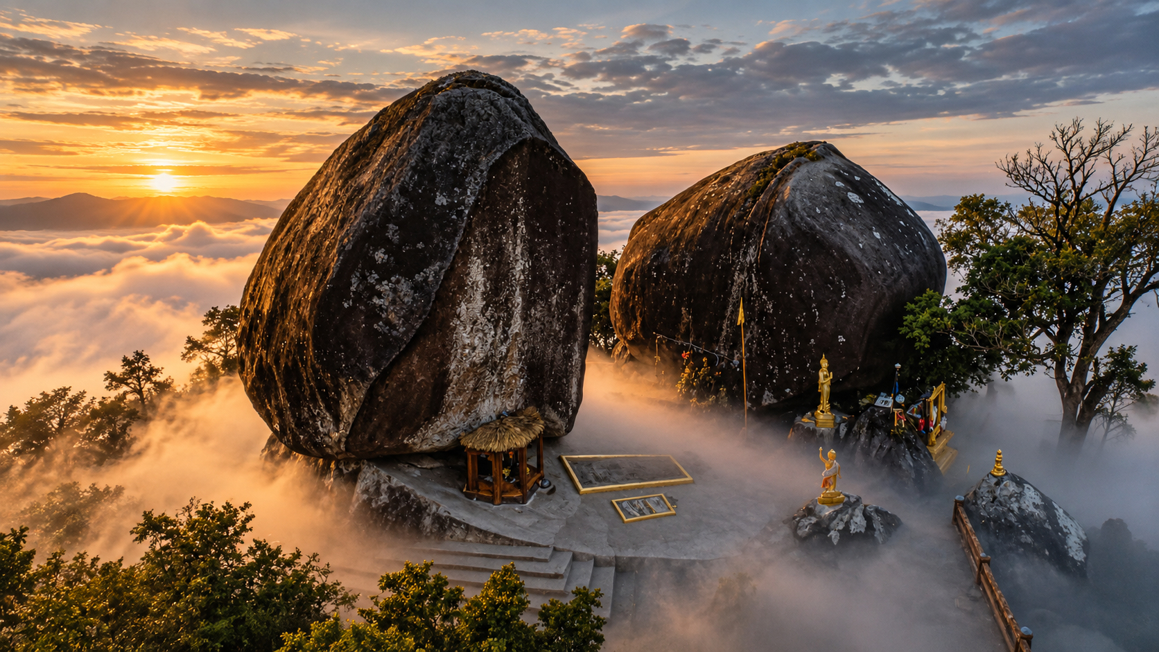
The Two Great Boulders
One of the most visually distinctive features of the summit is the presence of massive rounded granite boulders surrounding the sacred area.
These rocks are not decorative structures. They are natural granite formations shaped over geological time through weathering and erosion. The enormous rounded forms create the dramatic setting that visitors associate with the summit.
Faith here does not replace the landscape.
Faith is experienced through the landscape.
The Story of the Footprint
The exact historical origin of the pilgrimage tradition is not fully documented. The Department of National Parks states that the footprint was known to have been discovered in 1854 (B.E. 2397), while the modern development of access to the summit is associated with Luang Pho Khian, who pioneered the route in the early 1970s.
In 1972, he is recorded as having pioneered the route and taken a vehicle up the mountain for the first time. The route was subsequently improved and made progressively safer.
Local Buddhist tradition connects the footprint with the Buddha and regards the site as highly sacred. These are matters of religious belief and tradition, rather than claims that can be established through geological or historical science.
ThailandLover presents them as cultural beliefs, respectfully — not as scientifically verified historical events.
The Annual Pilgrimage
One of the most unusual aspects of Khao Khitchakut is that the sacred summit is not treated as an ordinary year-round tourist attraction.
The pilgrimage to Phra Bat Phluang traditionally takes place once each year for approximately two months, following the Thai lunar calendar. The exact Gregorian dates therefore change each year.
- 2024
- 10 February – 9 April
- 2025
- 29 January – 29 March
- 2026
- 19 January – 19 March
The pilgrimage season generally falls around late January to early April, but exact dates are announced annually.
The Department of National Parks confirms that the pilgrimage is an annual event and that the exact opening period follows the traditional lunar calendar.
The meaning of the pilgrimage
For many Thai Buddhists, visiting Phra Bat Phluang is not simply sightseeing. It is an act of merit, faith and personal pilgrimage. A long-standing belief associated with the site is that visitors may make a wish while paying respect to the footprint, traditionally asking for one wish.
During the pilgrimage period, enormous numbers of people travel to the mountain. The experience can therefore range from quiet and contemplative to extremely crowded depending on the day and time.
The Journey to the Summit
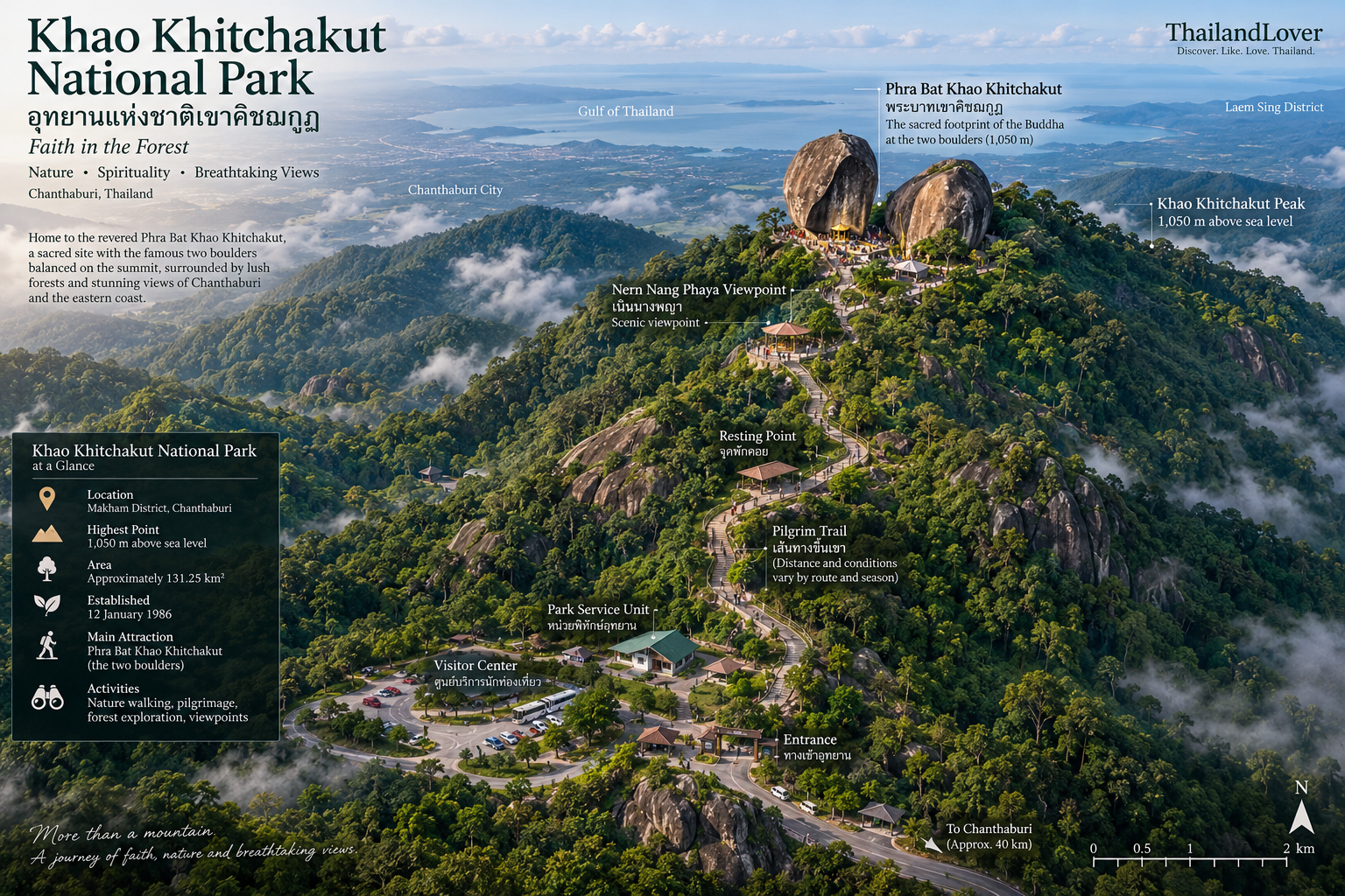
Reaching Phra Bat Phluang is part of the experience. The route is not simply a road leading directly to a viewpoint. The traditional journey involves ascending the mountain and continuing on foot toward the sacred summit.
Local tourism information describes access through Wat Phluang, followed by a steep mountain road and then a walking section. Other park information records different distances depending on which access point and route are being described — which is why a single simplified distance should not be treated as the entire pilgrimage route.
The practical journey can vary according to annual pilgrimage arrangements, vehicle service points, route conditions, temporary access restrictions, weather and crowd management.
During the 2026 pilgrimage, the official DNP announcement stated that songthaew services operated from Wat Phluang and Wat Krathing, with a round-trip service price of 200 THB per person at that time. These prices should be treated as season-specific, not permanent park pricing.
The Views from Khao Khitchakut
The summit provides an entirely different perspective on Chanthaburi. From the upper mountain, visitors can see surrounding mountain ranges, Sukim Mountain, the city of Chanthaburi, Noen Nang Phaya and coastal landscapes in the wider region, and — on clear days — islands and the Gulf of Thailand.
On clear mornings, the landscape stretches from dense forested mountains toward the agricultural plains and, farther away, the sea.
A mountain with a history of looking out to sea
During the period when France controlled Chanthaburi, the high point of Khao Khitchakut was reportedly used as an observation position for monitoring the sea and producing maps. This historical association is one explanation given for names such as “Farang Lookout” or “Khao Song Klong” associated with the summit landscape.
The same elevation that made the mountain spiritually significant also made it valuable for observing the surrounding landscape.
Krathing Waterfall
น้ำตกกระทิง
If Phra Bat Phluang represents the spiritual identity of the park, Krathing Waterfall represents its natural identity.
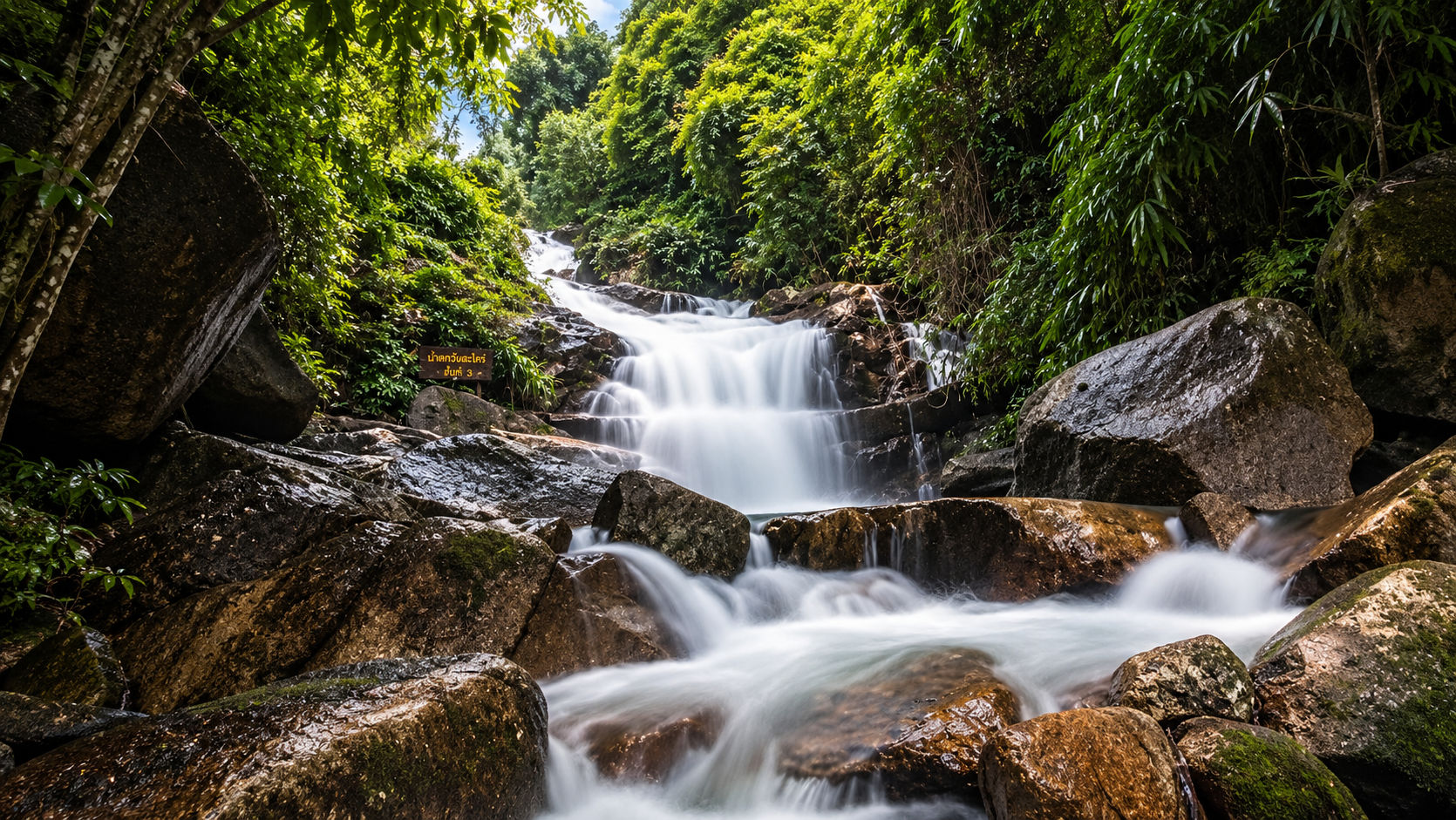
Krathing Waterfall is a large waterfall originating from the Khao Khitchakut mountain range. It descends through 13 levels, creating a long forest waterfall system rather than a single isolated cascade. The waterfall is surrounded by tropical forest, bamboo and abundant moisture-loving vegetation.
The stream is also known for its clear water and populations of freshwater fish, particularly mahseer-type fish known locally as Pla Phluang.
The most scenic sections are generally regarded as levels 8 and 9, while level 3 is a popular place for visitors to stop and enjoy the water where conditions permit.
- Level 3
- The lower waterfall section is popular because of its pool and relatively accessible character. It is often associated with recreational water activities when conditions are safe and the park permits them.
- Levels 8–9
- Widely regarded as the most beautiful sections. The surrounding forest becomes particularly impressive, with mosses, ferns and dense vegetation around the wet rock surfaces.
- Level 10
- The waterfall becomes powerful and the terrain more exposed. This section is also associated with panoramic views toward the surrounding forest. Thailand’s Office of Natural Resources and Environmental Policy and Planning identifies levels 8–9 as particularly scenic and level 10 as a viewpoint over the Thung Phlue reservoir and surrounding evergreen forest.
The lower stream area is close to the park headquarters, while reaching the higher levels requires considerably more walking. Tourism information has traditionally described the full waterfall walk as taking approximately three hours round trip, although actual walking time depends heavily on weather, fitness and trail conditions.
Other Waterfalls in the Park
- Khlong Chang Sao
- Approximately 10 kilometres from headquarters, associated with a nature-study loop of about 4 kilometres that traditionally takes around three hours. Better understood as a forest trail than a quick waterfall stop.
- Khlong Phai Boun
- Near park protection unit K.K.2. A larger stream-and-waterfall environment, historically associated with camping and park accommodation — useful for visitors who want to be away from the concentrated pilgrimage atmosphere.
- Khlong Krasiu
- Another stream-and-waterfall environment. Together with Khlong Phai Boun and Khlong Chang Sao, it shows that Khao Khitchakut is much more than the famous sacred mountain.
A Forest That Feeds a River
One of the most important ecological functions of Khao Khitchakut is its role as a watershed. The high mountain terrain gives rise to several important streams, including Khlong Krathing, Khlong Takhian, Khlong Thung Phlue and Khlong Phluang. These waterways contribute to the Chanthaburi River system.
The mountain is not merely a scenic backdrop. It is part of the natural infrastructure that supplies water to the wider landscape of Chanthaburi.
When to Visit
There are actually two different answers.
- For the sacred pilgrimage
- Visit during the annual Phra Bat Phluang pilgrimage season. Exact dates change every year and should be checked through the latest DNP announcement. For 2026, the official pilgrimage period was 19 January–19 March. Expect crowds.
- For nature
- Wetter months can produce much stronger waterfall flow and intensely green vegetation. Rain can also make trails slippery, and some attractions may be temporarily restricted. Current park notices should always take precedence over a static travel guide.
Climate in brief
Local environmental information gives an average annual rainfall of approximately 2,900 millimetres and an average annual temperature of about 27°C.
- Cool / drier: approximately mid-October to mid-February
- Hot season: approximately February–April
- Wet season: approximately mid-May to mid-October
Wildlife & Plant Life
The park’s steep terrain and relatively intact forest provide habitat for a wide range of wildlife. Local environmental information records mammals such as Asian elephant, gaur, fishing cat, serow, sambar, muntjac, wild boar, Malayan porcupine, bears, crowned gibbon and various civets, mongooses and squirrels — as well as hornbills, silver pheasant records, red junglefowl and many smaller forest birds. Streams and forest also support monitor lizards, snakes, turtles, frogs and toads.
These are habitat records, not a guarantee that visitors will encounter any particular species. Observe quietly and from a safe distance.
Two major forest types are particularly important. Tropical evergreen forest covers much of the park, including dipterocarps, bamboo, ferns, orchids and agarwood (Aquilaria). Above approximately 800 metres, vegetation begins to change into montane forest around Khao Phra Bat, with wild nut trees, bunnak, cinnamon relatives, wild figs and mountain shrubs.
The Geological Story
Khao Khitchakut is fundamentally a granite mountain system. The mountain’s bedrock is described as Jurassic-age igneous rock, with an estimated age of approximately 135–180 million years.
Long-term geological uplift, erosion and weathering shaped the mountain. The enormous rounded boulders found around the summit are products of this geological history. Over time, natural weathering rounded the granite into massive forms. Human culture then gave many of these formations names and stories.
Geology created the stones. Culture gave them meaning.
Hin Thoen — the balancing rock
Hin Thoen is one of the best-known geological features associated with the Khao Phra Bat landscape. The Department of Mineral Resources describes it as a natural balancing-rock formation on Khao Phra Bat. Access traditionally involves travelling through the mountain route toward Phra Bat Phluang and then continuing on foot.
What to Do
- 1. Make the pilgrimage to Phra Bat Phluang
- The signature experience. Come prepared for a genuine pilgrimage rather than a conventional sightseeing excursion.
- 2. Explore the granite landscape
- Look beyond the footprint. The summit contains remarkable natural rock formations that deserve to be understood as geology as well as cultural heritage.
- 3. Hike Krathing Waterfall
- Allow enough time to walk beyond the lower section. The upper waterfall levels reveal the strongest sense of the forest landscape.
- 4. Swim where permitted
- Some waterfall pools are suitable for recreation under appropriate conditions. Always follow current park instructions because water levels and currents can change rapidly.
- 5. Photograph the forest and stone
- Landscape, waterfall, geological, macro, forest, wildlife and cultural photography all have a place here.
- 6. Watch the sunrise — and look toward the Gulf
- Mist moving through the forest and the first sunlight over the surrounding landscape can transform the granite summit. On clear days, the elevation allows remarkably broad views across Chanthaburi toward the Gulf of Thailand.
Who Should Visit?
- Nature lovers
- Tropical forests, waterfalls and mountain landscapes.
- Photographers
- An unusual combination of granite, forest, mist, water and living faith.
- Hikers
- Routes range from relatively accessible walks to more demanding terrain.
- Cultural travellers
- The annual pilgrimage is a rare opportunity to experience a living Thai religious tradition.
- Geology enthusiasts
- The granite formations are among the most distinctive aspects of the landscape.
- Eastern Thailand travellers
- An excellent contrast to Chanthaburi’s old town, fruit-growing areas and coastal destinations.
Who may not enjoy it
This is not the ideal destination for travellers looking for resort-style relaxation, effortless sightseeing, flat walking routes, guaranteed solitude during pilgrimage season, or a purely secular tourist attraction.
The mountain demands some physical effort. And during the pilgrimage season, it can be extremely busy.
Responsible Travel
Khao Khitchakut is both a protected ecosystem and a sacred landscape. Visitors should therefore treat the mountain with particular respect.
- In the forest
- Do not litter. Do not feed wildlife. Do not collect plants or rocks. Stay on designated trails. Keep noise low.
- At the sacred site
- Dress respectfully. Follow local religious customs. Do not climb on sacred rocks. Do not disturb ceremonies. Follow instructions from officials and religious authorities.
- Around waterfalls
- Never underestimate current strength. Avoid slippery rocks. Do not enter restricted areas. Follow temporary closures.
How to Get There
Khao Khitchakut National Park is in Chanthaburi Province, approximately 40 kilometres north of Chanthaburi city according to local tourism information. The main road connection from Chanthaburi uses Highway 3249 toward Khao Khitchakut.
For the Phra Bat Phluang pilgrimage, access is handled differently from ordinary visits to the park headquarters. The pilgrimage route is associated with Wat Phluang and dedicated transport services that take visitors toward the mountain before the final ascent.
Khao Khitchakut National Park and the Phra Bat Phluang pilgrimage route are connected, but they are not the same visitor experience.
The park headquarters, Krathing Waterfall and other nature attractions are accessed through the park’s normal visitor infrastructure, while the sacred summit has its own seasonal pilgrimage arrangements.
How Long Should You Stay?
- Half day
- Krathing Waterfall and the lower forest.
- Full day
- Krathing Waterfall plus another nature trail and viewpoints.
- Overnight
- Forest atmosphere, photography, camping, early-morning landscapes and exploring multiple areas. Confirm accommodation with the park before travelling.
- Pilgrimage visit
- Treat the sacred mountain as a dedicated half-day or full-day experience. Do not try to squeeze the pilgrimage into a rushed itinerary.
Practical Information
- Name
- Khao Khitchakut National Park
- Thai
- อุทยานแห่งชาติเขาคิชฌกูฏ
- Province
- Chanthaburi
- Districts
- Makham and Khao Khitchakut
- Area
- 58.31 km² / 36,444.05 rai
- Established
- 4 May 1977 · 14th national park
- Highest Mountain
- Khao Phra Bat, approximately 1,085 m
- Buddha’s Footprint
- More than 1,050 m above sea level
- Main Waterfall
- Krathing Waterfall, 13 levels
- Pilgrimage
- Phra Bat Phluang — once annually, dates announced each year
ThailandLover’s Essential Guide
- Signature Experience
- Phra Bat Khao Khitchakut / Phra Bat Phluang
- Natural Highlight
- Krathing Waterfall — 13 levels through tropical forest
- Geological Highlight
- The giant granite boulders and Hin Thoen
- Best Forest Experience
- Khlong Chang Sao nature-study trail
- Best View
- Khao Phra Bat, toward Chanthaburi and the Gulf
- Most Interesting Story
- Where geology became sacred landscape
Frequently Asked Questions
- What is Khao Khitchakut National Park?
- Khao Khitchakut National Park, or อุทยานแห่งชาติเขาคิชฌกูฏ, is Thailand’s 14th national park, established on 4 May 1977 in Chanthaburi. It covers about 58.31 km² of granite mountains, tropical forest, waterfalls and the Phra Bat Phluang pilgrimage landscape.
- Is the Buddha’s Footprint open all year?
- No. The pilgrimage to Phra Bat Phluang traditionally takes place once each year for about two months, following the Thai lunar calendar. Exact Gregorian dates change annually. For 2026 the official period was 19 January–19 March.
- How high is the mountain?
- Khao Phra Bat is approximately 1,085 metres above sea level according to environmental and local-government sources. The Buddha’s Footprint site is more than 1,050 metres — a related but different figure.
- What is Krathing Waterfall?
- A 13-level waterfall originating from the Khao Khitchakut range. Levels 8–9 are widely regarded as the most scenic. The full walk has traditionally been described as about three hours round trip.
- Does the whole park close outside pilgrimage season?
- No. The sacred summit follows its own seasonal opening. The park also contains separate nature attractions such as Krathing Waterfall. Always check the latest DNP announcement before travelling.
- How do I get there?
- About 40 kilometres north of Chanthaburi city via Highway 3249. The pilgrimage route is associated with Wat Phluang and dedicated transport, which is different from ordinary access to headquarters and Krathing Waterfall.
- How do I contact the park?
- DNP lists 0 3960 9666. Confirm opening status, pilgrimage dates, waterfall access, camping and current conditions before travelling.
Related Destinations
- Khao Chamao–Khao Wong National Park
- Clear forest streams, waterfalls and limestone caves on the Rayong–Chanthaburi border — another side of eastern Thailand’s mountains.
- Namtok Phlio National Park
- A Chanthaburi waterfall park with clear pools and forest — a natural companion to a Khao Khitchakut journey.
- Nature & Parks
- More protected landscapes across ThailandLover’s national-park collection.
Location
Find Khao Khitchakut National Park
Phluang, Khao Khitchakut, Chanthaburi 22210