


National Park · Tak
Lan Sang National Park
อุทยานแห่งชาติลานสาง
Where Ancient Rock Meets Running Water
Waterfalls · Forest · Ancient Rock
A ThailandLover guide to a quiet mountain park near Tak, where forest streams flow over ancient metamorphic rock and a chain of waterfalls stays hidden in the Thanon Thong Chai landscape.
Forest, Waterfalls & the Mountain Landscape of Tak
Just beyond Tak, where the road begins climbing toward Mae Sot, a forested mountain landscape opens quietly on the western edge of the city.
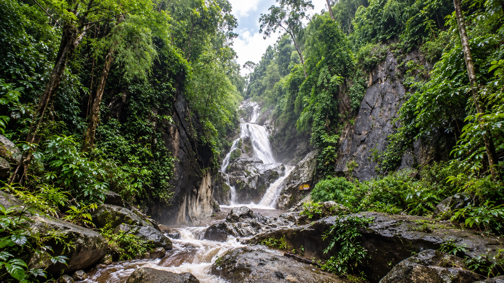
This is Lan Sang National Park — a relatively compact national park whose character is defined not by one enormous mountain, but by a network of forested slopes, streams, rock formations and waterfalls.
The park is especially known for its sequence of waterfalls along the Lan Sang stream, including Pha Lat, Lan Liang Ma, Lan Sang and Pha Phueng, together with additional waterfalls deeper in the park.
For travellers passing through Tak, Lan Sang is easy to overlook. That is precisely what makes it interesting. It is close enough to visit without committing to a major expedition, yet sufficiently wild to provide a genuine forest experience.
A water-and-forest national park — where mountain streams have shaped ancient metamorphic rock into waterfalls, pools and natural terraces.
At a Glance
- 104 km²
- Published park area — 65,000 rai.
- 1979
- Established 14 May, as Thailand’s 15th national park.
- ~20 km
- From Tak town, on Highway 12 toward Mae Sot.
- 4 waterfalls
- Pha Lat → Lan Liang Ma → Lan Sang → Pha Phueng.
- 650+ million years
- Approximate age of some Precambrian metamorphic rock here.
- Official Name
- Lan Sang National Park
- Thai Name
- อุทยานแห่งชาติลานสาง
- Province
- Tak
- District
- Mueang Tak
- Subdistrict
- Mae Tho
- Region
- Western / Northern Thailand
- Published area
- 104 km² / 65,000 rai
- Established
- 14 May 1979 · National Park No. 15
- Landscape
- Mountain forest, streams, waterfalls and rocky terrain
- Main Stream
- Lan Sang Stream
- Main Attractions
- Lan Sang, Pha Lat, Lan Liang Ma and Pha Phueng waterfalls
- Other Waterfalls
- Pha The · Pha Noi · Tha Le
- Viewpoint
- Khao Noi Viewpoint
- Main Access
- Highway 12, Tak–Mae Sot
- Visitor Character
- Waterfalls, forest walks, short nature visits, camping
- Best Known For
- The Lan Sang waterfall sequence
Where Is Lan Sang National Park?
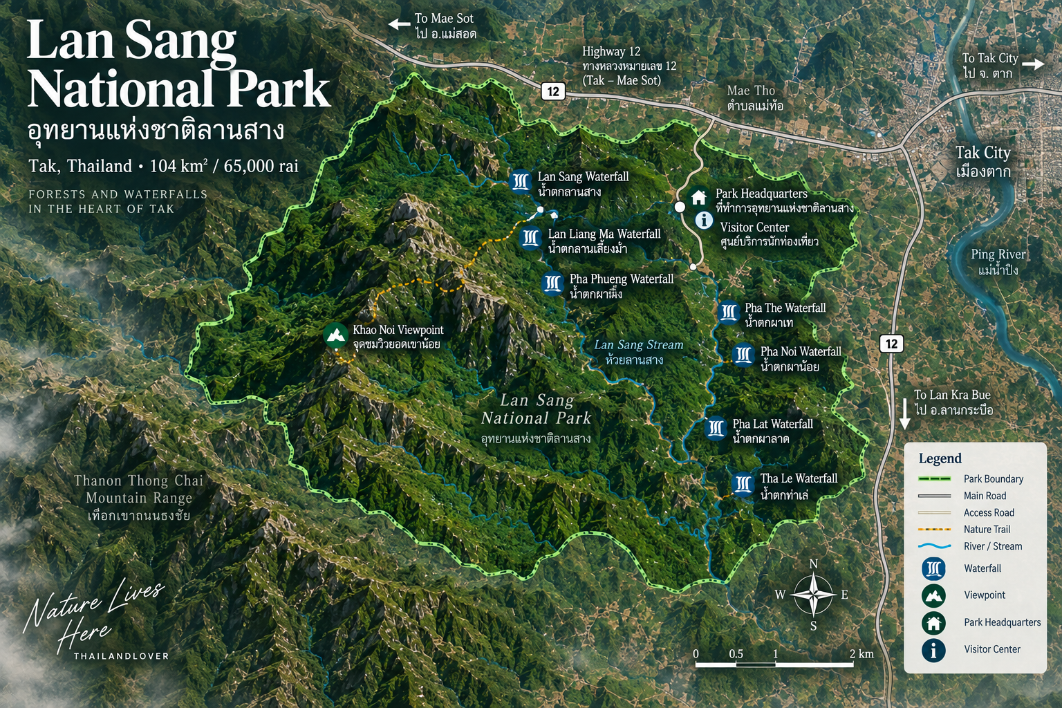
Lan Sang National Park is in Mae Tho Subdistrict, Mueang Tak District, Tak Province. It lies along the Tak–Mae Sot corridor, which makes it one of the more accessible national parks in western Thailand.
From Tak town, the park is roughly 20–21 kilometres away, depending on the starting point and route. The principal approach is Highway 12 toward Mae Sot, with the park entrance branching from the highway.
You do not have to travel deep into the countryside for hours before reaching the forest. The transition can be surprisingly quick:
Tak town → Highway 12 → forested mountain foothills → Lan Sang
The Landscape
Lan Sang occupies a mountainous section of the Thanon Thong Chai mountain system. The terrain is predominantly hilly, with higher ground toward the west and south and lower terrain toward the east.
Several streams drain through the park. They are fundamental to its identity. Rather than one isolated waterfall, Lan Sang holds a sequence of falls and rocky stream environments formed by the same broader drainage system. A visit feels more like exploring a waterfall landscape than ticking off a single fall.
- Lan Sang Stream — the stream that names the park and carries the main waterfall sequence
- Huai Tha Le — a side waterway in the wider stream network
- Khlong Huai Sai — another drainage through the forested slopes
- Huai Um Yom — part of the same mountain catchment
A Park Built Around Water
The most important natural feature of Lan Sang is its relationship with water. Rainfall from the surrounding mountains feeds streams that descend through forested terrain. Where the streams meet resistant rock, water accelerates, cuts channels and drops over ledges.
Over time, that produces waterfalls, plunge pools, rocky terraces, channels, small rapids and natural swimming areas. The result is a connected waterfall landscape, not a collection of unrelated attractions.
The Geology of Lan Sang
One of the most interesting aspects of Lan Sang is geological rather than purely scenic. Investigations by the Department of Mineral Resources identify much of the area as underlain by metamorphic rocks, particularly gneiss.
Some of these rocks date to the Precambrian, with ages exceeding approximately 650 million years. The gneiss shows characteristic banding and mineral alignment created by intense heat and pressure. In some places it displays an augen gneiss texture, where quartz and feldspar form lens- or eye-like structures.
This ancient foundation is the resistant surface modern streams flow over.
The waterfalls are young expressions of an extremely old geological landscape.
The Forest
The park is predominantly forested. Historical forest-resource surveys describe several forest environments within the 104 km² park. The mixture reflects changing elevation, moisture and terrain.
- Mixed deciduous forest
- 75.11 km² · about 72%
- Hill evergreen forest
- 17.33 km² · about 17%
- Dry evergreen forest
- 5.78 km² · about 6%
- Other planted / forest areas
- 5.78 km² · about 6%
- Survey total
- 104.00 km²
Lan Sang Waterfall
น้ำตกลานสาง · the park’s signature landscape
This is the waterfall that gives the national park its name. It is part of the sequence along Lan Sang stream, and the best-known natural feature in the park.
It is not best understood as one enormous vertical drop. Lan Sang is a multi-level rocky stream landscape, where water moves through a series of natural formations. Dark metamorphic rock, clear mountain water, forest vegetation, pools, cascades and shaded banks create the characteristic scene.
This is the part of the park where the relationship between geology and water is easiest to see.
The Lan Sang Waterfall Sequence
One of Lan Sang’s most distinctive characteristics is the progression of waterfalls along the stream. Department of Mineral Resources visitor-route material shows them connected along the same landscape, with footpaths linking the attractions. That suits visitors who prefer walking between natural features rather than driving from one isolated site to another.
Pha Lat → Lan Liang Ma → Lan Sang → Pha Phueng
- 1 · Pha Lat
- น้ำตกผาลาด — the sloping cascade that opens the route.
- 2 · Lan Liang Ma
- น้ำตกลานเลี้ยงม้า — water squeezed through a narrow rock opening.
- 3 · Lan Sang
- น้ำตกลานสาง — the namesake, multi-level rocky stream.
- 4 · Pha Phueng
- น้ำตกผาผึ้ง — farther upstream, if the trail is open.
Pha Lat Waterfall
น้ำตกผาลาด
Pha Lat is one of the first major waterfall features on the park’s waterfall route. The name refers to a rocky cascade where water moves over sloping rock. It begins the more intimate waterfall experience, before the route continues toward Lan Liang Ma and Lan Sang. The surroundings are heavily forested, with rocky channels and shade.
Lan Liang Ma Waterfall
น้ำตกลานเลี้ยงม้า · about 10 metres at one principal drop
Lan Liang Ma is closely associated with the rock formations of the Lan Sang stream. Geological information from the Department of Mineral Resources identifies the waterfall as approximately 10 metres high at one of its principal drops. Water is channelled through a relatively narrow opening before falling into the lower area. The rock compresses the stream, then releases it.
There are places to rest, and — when conditions are considered safe — to enjoy the water.
Pha Phueng Waterfall
น้ำตกผาผึ้ง
Pha Phueng lies farther upstream from Lan Sang Waterfall. It is reached by continuing along the stream, not by treating Lan Sang as the endpoint. That is one reason the park rewards visitors willing to walk. The farther you move into the system, the more the landscape shifts from a conventional visitor area into a forest-and-stream environment.
Further Waterfalls
Three more falls sit in the park’s network of streams and trails. For ThailandLover, they belong to the Lan Sang waterfall system. They are not independent major destinations, and they should not be oversold as such.
- Pha The · น้ำตกผาเท
- On the park’s established tourism route and the Department of Mineral Resources visitor map. A secondary nature feature, best as part of a broader walk.
- Pha Noi · น้ำตกผาน้อย
- Its appeal is the surrounding forest and rock, not the scale of the fall.
- Tha Le · น้ำตกท่าเล่
- Less prominent in general tourism coverage, and still part of the wider picture: this is a landscape of several streams, not one waterfall.
Khao Noi Viewpoint
จุดชมวิวยอดเขาน้อย
Khao Noi Viewpoint is a different experience from the waterfall zone. Instead of looking into the forest from ground level, it opens the landscape outward toward Tak town and the surrounding terrain. It is a useful complement to the waterfall route, reached from the area near the park visitor facilities.
Forest close-up, then the mountain landscape at distance.
The Forest Experience
Lan Sang is not a park where the main experience depends on reaching a summit. Its strongest experience happens at a lower scale. Listen to the stream. Look at the rock. Notice how the forest closes around the water. Watch how the light changes between the canopy and the river.
This is a park where the micro-landscape matters. A ten-metre waterfall surrounded by ancient rock and dense forest can be more memorable than a much larger waterfall in a heavily developed tourist area.
Wildlife
Lan Sang’s forest provides habitat for a range of wildlife. Sources describing the park mention animals including wild boar, barking deer, sambar deer, serow, common palm civet, various reptiles and birds. Local biodiversity notes also mention Pallas’s squirrel and related forest squirrels, flying lizards, bulbuls and other forest birds, and Siamese giant turtles in suitable habitats.
Species presence is not a guarantee of sightings. Wild animals in a national park are naturally elusive.
Move quietly. Do not try to make the animal appear.
Birdwatching
Lan Sang is an interesting stop for birdwatchers because several habitats sit in a relatively small area: deciduous forest, evergreen forest, streams, waterfall environments and mountain slopes.
A specialist birding source recorded species such as Blue-winged Pitta and Small Minivet during field observation, and notes that the park remains relatively under-studied by birdwatchers. A park that receives less birding attention can reward patient exploration.
The Story Behind the Name “Lan Sang”
The name Lan Sang is traditionally associated with a local historical legend concerning King Taksin the Great. According to the traditional story, during a military campaign toward Chiang Mai, King Taksin became separated from his forces in the forest. His troops later saw a light and heard the sound of a war horse. They followed the phenomenon and found the king mounted on horseback in a rocky clearing, around dawn.
The area consequently became associated with the name “Lan Sang”, interpreted in the local tradition in connection with light appearing at dawn. The area around the waterfall is also traditionally associated with marks said to resemble the hoofprints of the king’s horse.
Lan Sang & King Taksin
The association is particularly appropriate because Tak itself has a strong connection with King Taksin the Great. The natural value of the park, though, does not depend on the legend. The geological record is far older — Precambrian metamorphic rock, hundreds of millions of years — while the cultural story belongs to a much more recent historical period.
Ancient rock, living forest and a human story layered across the same landscape.
The Proposed Expansion
In October 2022, the Department of National Parks announced a public-participation process concerning the proposed incorporation of approximately 65,000 rai / 104 km² of the Pradang–Wang Chao National Reserved Forest into Lan Sang National Park. The stated ecological rationale was that the forest forms a larger connected forest complex with Khlong Wang Chao National Park and connects toward the western forest landscape.
Getting There
- From Tak city
- About 20 km. Tak → Highway 12 toward Mae Sot → Lan Sang. A specialist access reference places the entrance about 12 km west of the Highway 1 / Highway 12 junction, then an entrance road into the park.
- By car
- The easiest way. Close enough to combine with other places in the province. The access road leads toward the checkpoint, visitor facilities, waterfall area, parking and camping. Do not confuse the park road with the highway.
- From Mae Sot
- Approach eastward on Highway 12 toward Tak. Convenient as a stop on a Tak–Mae Sot or Mae Sot–Tak road trip.
How Long Should You Spend?
- 2–3 hours
- Entrance, the Lan Sang waterfall area, a short walk and basic photography.
- Half day · recommended minimum
- Waterfall route, forest walk, Khao Noi, and time to explore without rushing the first hour.
- Full day
- Several waterfalls, more trail time, forest photography, birds, a picnic, and the park without a clock.
- Overnight
- Camping, early-morning forest, slower walks, birdwatching and photography.
A ThailandLover Half-Day Escape
A suggested sequence from Tak. Adjust it to current trail access, weather and park instructions.
- 08:00
- Leave Tak.
- 08:30
- Arrive at Lan Sang.
- 08:45
- Visitor area, then the waterfall route.
- 09:15
- Pha Lat Waterfall.
- 09:30
- Lan Liang Ma Waterfall.
- 10:00
- Lan Sang Waterfall.
- 10:45
- Continue toward Pha Phueng if access allows.
- 12:00
- Back toward the main visitor area.
- 12:30
- Lunch or a rest.
- 13:30
- Khao Noi Viewpoint.
- 14:30
- Depart.
Best Time to Visit
- November – February
- Best overall. Cooler walking, pleasant mornings, softer light.
- June – October
- Best for waterfalls. Stronger flow, greener forest. Rocks are slippery, trails muddy, crossings hazardous. Check conditions.
- March – May
- Hot season. Temperatures rise and some streams run lower. Still attractive if you go early.
Best Time of Day
- Early morning
- Best overall. Cooler, softer light, better wildlife potential.
- Late afternoon
- Excellent for photography. The forest warms in tone as the sun drops.
- Midday
- Fine for a swim or a rest, less comfortable for hiking.
Photography
Lan Sang suits photographers who enjoy water, rock and forest in the same frame.
- Waterfalls
- Slower shutter speeds to emphasise flowing water.
- Rocks
- Gneiss gives strong geological texture.
- Forest
- Look for layers, not only trees.
- The stream
- Follow the water. Do not photograph only the drop.
- Khao Noi
- The viewpoint for a wider landscape.
A Different Kind of Waterfall Park
Thailand has many waterfall destinations. Lan Sang is different because its waterfalls sit relatively close together. You can move through rock, stream, cascade, pool, forest and another waterfall without travelling long distances between separate sites.
That gives the park a strong sense of continuity. The waterfalls feel like different chapters of the same river story.
Rock → stream → cascade → pool → forest → another waterfall
Facilities
Park facilities have historically included a visitor centre, headquarters, parking, accommodation, camping, nature trails, waterfall access and picnic or rest areas. A local DASTA tourism source lists park houses and camping, and notes that conditions and charges should be checked with the park before travelling.
Fees and facilities change. ThailandLover does not hard-code old accommodation prices into this page. Confirm current charges, house availability and trail access with the park.
Waste Management
One of the more distinctive visitor-management practices at Lan Sang is its carry-out waste policy. Instead of relying on conventional bins throughout the attraction area, visitors have historically been asked to receive a rubbish bag and carry waste back to the designated collection point.
What you bring into the forest, you take out.
Local sustainable-tourism information has documented the practice. For ThailandLover it is part of the visit, not only a regulation.
Swimming & Water Safety
Some waterfall pools and stream areas have traditionally been used for recreation. Never assume every pool is safe. Risks include slippery rock, submerged rocks, sudden changes in water level, strong current after rain, and flash-flood conditions.
During heavy rain, the safest choice is to stay away from streams and waterfalls.
Never enter a waterfall channel simply because other visitors are doing so.
What to Bring
- Drinking water and a light snack if you plan to stay through midday
- Comfortable walking shoes, insect repellent and sun protection
- Light rain protection, a dry bag, and a small first-aid kit
- Binoculars if you are watching birds, and a rubbish bag
- For camping: a warm layer, a headlamp, proper kit and waterproof storage
Who Should Visit?
- Waterfall lovers and nature photographers
- Short hikes, families, and first-time national park visitors
- Road-trip travellers passing through Tak
- Campers, birdwatchers and anyone curious about geology
- Visitors who prefer smaller, quieter parks
- First-time park visitors
- Approachable. You do not need a multi-day trek to experience a genuine national park.
- Families
- The waterfall environment can work well, subject to current safety conditions.
- Photographers
- Water, rock and forest in the same compositions.
- Road trippers
- On Highway 12, an easy addition to a Tak–Mae Sot journey.
Who May Not Love It?
Lan Sang may not be the right choice if you expect enormous Himalayan-style mountains, very long trekking routes, dramatic cliff scenery, extensive tourist infrastructure, luxury facilities, a large number of restaurants and cafés, or a single spectacular bucket-list viewpoint.
Its strength is not scale. Its strength is intimacy.
Nearby National Park Context
Lan Sang sits in a wider western Thailand forest landscape. It is close to the route toward Taksin Maharat National Park, so the two can be combined on a longer Tak-area itinerary. The Department of National Parks has also identified forest connectivity between proposed expansion areas of Lan Sang and Khlong Wang Chao National Park, which matters for conservation. Protected areas are not always isolated green islands. Their ecological value can increase when they remain connected to larger forest systems.
Lan Sang vs. Larger Thai National Parks
Lan Sang is relatively small at 104 km². That is part of its character. Compared with very large national parks, it can feel more compact, easier to explore, less intimidating, more focused on waterfalls and forest, and more suitable for a short nature escape.
It is not a park you need to conquer. It is a park you can simply walk into.
ThailandLover Rating
An editorial assessment of the destination experience, not an official government rating. Lan Sang scores particularly well for an accessible combination of waterfalls, forest and geology, rather than extreme trekking or large-scale wilderness.
- Waterfalls
- A sequence, not a single drop.
- Forest experience
- The micro-landscape is the point.
- Geology
- Ancient gneiss under living water.
- Landscape
- Intimate slopes, plus Khao Noi.
- Photography
- Water, rock and forest together.
- Hiking
- Walks between falls, not a long trek.
- Wildlife
- Habitat, not a promised sighting.
- Birdwatching
- Under-studied, and worth the patience.
- Accessibility
- About 20 km from Tak on Highway 12.
- Camping
- A slower way to hear the forest.
- Facilities
- Park houses and camping — confirm first.
- Overall
- Follow the water. Stay a little longer.
Essential Information
- Destination
- Lan Sang National Park · อุทยานแห่งชาติลานสาง
- Location
- Mae Tho, Mueang Tak, Tak
- Area
- 104 km² / 65,000 rai
- Established
- 14 May 1979 · National Park No. 15
- Main road
- Highway 12, Tak–Mae Sot · about 20 km from Tak
- Main stream
- Lan Sang Stream
- Waterfall sequence
- Pha Lat → Lan Liang Ma → Lan Sang → Pha Phueng
- Other waterfalls
- Pha The · Pha Noi · Tha Le
- Viewpoint
- Khao Noi
- Landscape
- Thanon Thong Chai mountain system
- Geology
- Metamorphic rock, including gneiss
- Activities
- Waterfall walks, nature study, photography, birdwatching, camping
- Contact
- +66 55 894 640 · +66 62 461 5120
Frequently Asked Questions
- What is Lan Sang National Park?
- A compact mountain park in Mae Tho, Mueang Tak, on the Highway 12 road toward Mae Sot. It is a water-and-forest park: streams have shaped ancient metamorphic rock into waterfalls, pools and terraces, rather than one enormous mountain.
- How large is the park?
- The established published area is 104 km² (65,000 rai). A 2022 announcement opened a survey and public-participation process about adding further reserved forest. That proposal is not a completed new boundary.
- When was it established?
- Thailand’s 15th national park, by Royal Decree published in the Royal Gazette on 14 May 1979.
- How do I get there from Tak?
- About 20–21 km via Highway 12 toward Mae Sot. A specialist access reference places the entrance about 12 km west of the Highway 1 / Highway 12 junction, then an entrance road. A car is the practical way. From Mae Sot, come east on the same highway.
- Which waterfalls should I walk?
- The principal sequence is Pha Lat, Lan Liang Ma, Lan Sang and Pha Phueng, linked by footpaths. Pha The, Pha Noi and Tha Le are further falls in the same system. Khao Noi looks back toward Tak.
- When should I go?
- November to February is the most comfortable for walking. June to October usually means stronger falls and wetter trails. March to May is hotter, so go early. Early morning is the best time of day.
- Can I swim?
- Some pools have traditionally been used for recreation. Not every pool is safe. Slippery rock, submerged rocks, rising water and flash floods are real risks. In heavy rain, stay away from streams and waterfalls.
- How long do I need?
- Two to three hours covers the entrance and the main fall. A half day is the recommended minimum. Stay a full day or overnight for several falls, birds and camping.
More of Tak & the Western Forests
- Taksin Maharat National Park
- Close enough to the same Tak routes that the two parks can share a longer itinerary.
- Khlong Wang Chao National Park
- Part of the wider western forest the Department of National Parks has linked, in conservation terms, with Lan Sang.
- Khlong Lan National Park
- Another waterfall-and-forest landscape in the same western mountain country.
- Namtok Pha Charoen National Park
- A different Tak waterfall park, farther south toward the border hills.
Location
Find Lan Sang National Park
Mae Tho, Mueang Tak, Tak 63000 · about 20 km west of Tak on Highway 12