



National Park · Kamphaeng Phet
Khlong Lan National Park
อุทยานแห่งชาติคลองลาน
Where Water Falls from the Forest
Kamphaeng Phet · Lower Northern Thailand
A mountain sanctuary in Kamphaeng Phet where ancient metamorphic rock, deep forest and headwater streams converge to create one of Thailand’s most impressive accessible waterfalls.
The Waterfall Is Only the Beginning
There are places in Thailand where the landscape announces itself with dramatic peaks. Khlong Lan is different. Here, the mountains are important — but water is the storyteller.
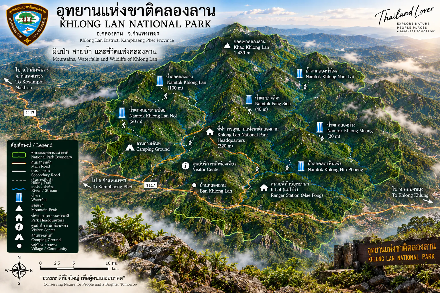
From a rugged forested landscape rising to Khun Khlong Lan at approximately 1,439 metres, streams gather in the highlands before plunging over cliffs, flowing through granite and metamorphic rock, and continuing toward the Ping River basin. At the heart of this landscape is Khlong Lan Waterfall, a broad 100-metre cascade that has become one of Kamphaeng Phet’s defining natural landmarks.
Yet the waterfall is only the beginning. Beyond the famous viewpoint lies a 300-square-kilometre protected landscape of mountain forests, headwaters, caves, streams, rapids and less-visited waterfalls.
Come for Khlong Lan Waterfall. Stay for the forest.
Khlong Lan at a Glance
- Official Name
- Khlong Lan National Park
- Thai Name
- อุทยานแห่งชาติคลองลาน
- Province
- Kamphaeng Phet
- Districts
- Khlong Lan and Mueang Kamphaeng Phet
- Area
- 187,500 rai / 300 km²
- National Park No.
- 44th national park of Thailand
- Established
- 25 December 1982 (B.E. 2525)
- Highest Point
- Khun Khlong Lan — approx. 1,439 m
- Landscape
- Rugged mountain terrain, forested valleys and headwater streams
- Major Watersheds
- Khlong Khlung, Khlong Suan Mak and associated streams toward the Ping River
- Signature Attraction
- Khlong Lan Waterfall
- Other Attractions
- Khlong Nam Lai, Phet Cha Kho, Khlong Suan Mak, Kaeng Ko Roi, Kwang Chang / Kio Ngong Chang
- Main Forest Types
- Dry evergreen, mixed deciduous, dry dipterocarp, bamboo
- Main Access
- Khlong Lan District, Kamphaeng Phet
- Park Contact
- 088-407-9915
- Authority
- Department of National Parks, Wildlife and Plant Conservation
The 187,500-rai / 300-km² figure is the official gazetted park area published by the Department of National Parks. Some commercial tourism websites currently quote larger figures, but ThailandLover uses the legal park figure.
The Story of Khlong Lan
Khlong Lan became Thailand’s 44th national park when the Royal Decree establishing the park was published in the Royal Gazette, Volume 99, Part 191, on 25 December 1982.
The story began several years earlier. In 1978, forest authorities surveyed the Khlong Lan Waterfall area because of its scenic value and importance as a forest and watershed. Further investigation found that the wider Khlong Lan forest contained extensive mountain terrain, valuable forest resources and important headwaters. A national-park proposal followed, and in 1982 the area was formally designated.
Some secondary sources incorrectly state 1985. DNP regional information and the Royal Gazette identify 25 December 1982 as the establishment date.
A Mountain Landscape Built Around Water
Khlong Lan is essentially a watershed landscape. The terrain consists of interconnected mountains, ridges, valleys and streams. The eastern side becomes comparatively flatter, while the western and central portions are dominated by more rugged mountainous terrain.
At the centre is Khun Khlong Lan, rising to approximately 1,439 metres — the highest point identified by the park authority. The mountains form the headwaters of Khlong Khlung, Khlong Suan Mak, Khlong Lan, Khlong Nam Lai and associated tributaries, which eventually contribute to the Ping River basin.
Khlong Lan should not be viewed simply as a waterfall destination. The waterfalls are the visible expression of a much larger mountain watershed.
The Geology Beneath Khlong Lan
Khlong Lan is geologically more interesting than its classic waterfall photographs suggest. The landscape contains metamorphic basement rocks including gneiss, paragneiss, schist, calc-silicate rocks and marble.
A geological survey by the Department of Mineral Resources identifies orthogneiss and paragneiss around the Khlong Lan waterfall area, with calc-silicate rock interlayered with grey gneiss near the waterfall itself. Scientific studies of Khlong Lan paragneiss have identified complex metamorphic histories, including an important Indosinian-age component, as part of northwestern Thailand’s basement complex.
Hard metamorphic rock + steep mountain relief + concentrated streams = dramatic waterfalls, rock channels and cascades.
Forests of Khlong Lan
Khlong Lan’s ecological importance comes from forest communities distributed according to elevation, moisture and terrain.
- Dry evergreen forest
- Occurs particularly in higher and more humid mountain areas. Reported trees include Hopea / ตะเคียนทอง, ตะเคียนหิน, สมพง, ยมหอม, พะยอม and สมอพิเภก. These forests remain comparatively green because of moisture, even though the wider landscape has a pronounced dry season.
- Mixed deciduous forest
- One of the park’s characteristic communities. Important trees include teak (Tectona grandis), Burma padauk (Pterocarpus macrocarpus), ตะแบก, Afzelia / มะค่าโมง and various bamboos. In the dry season, deciduous trees shed their leaves, creating a very different visual character from the evergreen valleys.
- Dry dipterocarp forest
- Occurs particularly around 400–600 metres. Typical species include เต็ง, รัง, เหียง, พลวง, ยางกราด, ยอป่า and สมอพิเภก. This forest type is strongly influenced by seasonality and fire ecology.
- Bamboo and grass communities
- Bamboo occurs in patches throughout the park. Grassland and former disturbed areas have developed into secondary vegetation. Some former agricultural or settlement areas have undergone natural regeneration, creating transitional habitats used by wildlife.
Wildlife
Khlong Lan supports a diverse range of wildlife because it combines mature forest, mountain slopes, streams, caves, cliffs, mixed forest types and transitional habitats. Older biodiversity surveys recorded at least 265 wildlife species across 81 families — a historical survey figure, not a claim that it represents the park’s complete contemporary inventory.
Reported mammals include Asian elephant, gaur, banteng, sambar deer, barking deer, wild boar, white-handed gibbon, leopard, clouded leopard, tiger, black bear, various civets, squirrels, otters and smaller forest mammals. Historical survey material also records numerous amphibians, reptiles and freshwater fish.
Species such as tiger, leopard and clouded leopard in older inventories should not be interpreted as a guarantee that visitors will encounter them today. Khlong Lan remains important habitat, but most of its larger and more elusive mammals are rarely seen by ordinary visitors. The forest itself — not a promised wildlife sighting — is the attraction.
Khlong Lan Waterfall
น้ำตกคลองลาน
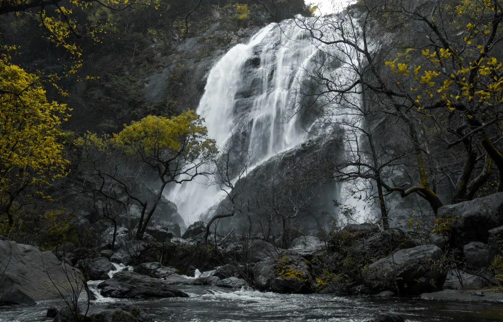
If one image defines Khlong Lan, it is the enormous white curtain of Khlong Lan Waterfall. The waterfall originates from the mountain system around Khun Khlong Lan. During the wet season, several streams converge in the upper valley before flowing through a deeper basin and reaching the cliff.
The final drop is approximately 100 metres high × 40 metres wide, descending into a large pool and stream environment below. Current DNP regional information places the waterfall approximately 500 metres from park headquarters, making it one of Thailand’s unusually accessible major waterfalls.
The surrounding area provides waterfall viewing, riverside relaxation, picnic areas, camping, photography, nature study and access to a short educational trail. The combination of scale, accessibility and forest setting is what makes Khlong Lan Waterfall special.
The Khlong Lan Nature Trail
Near headquarters is a nature-study trail associated with Khlong Lan Waterfall. The trail is approximately 1 kilometre long and contains 11 educational stations.
Rather than treating the waterfall simply as a photo stop, the trail provides an opportunity to understand the surrounding forest, watershed and ecological relationships.
The waterfall is the destination, but the forest is the lesson.
Khlong Nam Lai Waterfall
น้ำตกคลองน้ำไหล · Pang Khwai
Approximately 25 kilometres from the main park headquarters lies Khlong Nam Lai Waterfall, also known historically as Pang Khwai Waterfall. Unlike the enormous single-drop appearance of Khlong Lan, Khlong Nam Lai is a multi-tiered waterfall, cascading through approximately nine levels.
The landscape includes broad dark rock surfaces, pools and stream channels. The different levels create a more intimate waterfall experience. Access is through the Khlong Nam Lai / Pang Khwai area, branching from Highway 1117 and continuing for approximately 10 kilometres toward the waterfall.
Khlong Lan is the great curtain. Khlong Nam Lai is the staircase.
Phet Cha Kho Waterfall
น้ำตกเพชรชะโค
Phet Cha Kho is another substantial waterfall within the park’s wider landscape. It consists of approximately four major levels, with each level exceeding 30 metres; the fourth is reported at more than 70 metres.
The waterfall is reached from Khlong Phet Niyom Ranger Station, followed by approximately 1.5 kilometres of walking. Unlike Khlong Lan Waterfall, Phet Cha Kho is much more dependent on seasonal water conditions and can become significantly weaker during the dry season.
This is a different Khlong Lan experience: less infrastructure, more forest, more walking, and a stronger sense of being away from the main visitor zone.
Khlong Suan Mak and Kaeng Ko Roi
Khlong Suan Mak is one of the important waterways associated with the Khlong Lan landscape. The stream is fed by water emerging from the forests of Khlong Lan and neighbouring Khlong Wang Chao National Park before forming a larger river system. Its rocky character has historically created rapids, pools and small islands, and has been associated with outdoor and river-based recreation during suitable water conditions.
Kaeng Ko Roi — the rapids of a hundred rock islands — is one of Khlong Lan’s more adventurous landscapes. The name refers to numerous rocks and small formations that create the appearance of islands scattered through Khlong Suan Mak. Historically the area became known for rafting and river activities.
The landscape has changed over time. Local documentation notes that construction of a weir on Khlong Suan Mak altered the former rapids, meaning older photographs and descriptions should not automatically be assumed to represent current conditions.
The place remains historically significant as a river landscape, but its physical character has changed.
Kwang Chang Viewpoint
กวางช้าง · Kio Ngong Chang
One of the most rewarding viewpoints near park headquarters is the Kwang Chang / Kio Ngong Chang area, associated with the broader Khao Hua Chang trail system. The initial nature trail is approximately 735 metres / around 45 minutes and climbs through relatively steep terrain.
The viewpoint provides an elevated perspective over the surrounding forest and allows visitors to see Khlong Lan Waterfall from another angle. A further section of approximately 700 metres continues toward Khao Hua Chang and requires a ranger guide. The terrain becomes steeper and includes sections along a ridge with exposure. Park information specifically warns that the route is unsuitable for young children, elderly visitors and people with certain medical conditions. Visitors should remain on the designated trail.
From the valley, Khlong Lan is a wall of water. From the ridge, it becomes part of the mountain.
Caves and Karst-Related Features
The park landscape also contains caves and rock shelters. Historical tourism information describes caves in the Khlong Suan Mak area, including Sai Hai Sok Cave and Sant Suk Cave, with stalactites, stalagmites and habitat for bats.
Access should be undertaken only with park personnel where required. Older park information specifically recommends contacting the ranger unit and having an official guide accompany visitors. This is not a cave-tour destination in the same sense as Thailand’s famous show caves.
Its value is the relationship between rock, groundwater, forest and wildlife.
Climate and When to Visit
Khlong Lan experiences a tropical seasonal climate with three broad periods.
- Hot season · March–May
- Temperatures rise significantly, particularly during the daytime. Historical park information records April as the hottest period, with maximum temperatures reaching approximately 38°C in some years.
- Rainy season · May–October
- The forest becomes intensely green and waterfalls generally reach their greatest visual strength. For photographers: powerful waterfalls, mist, saturated vegetation, dark wet rock and dramatic clouds. Trails and mountain roads can become slippery.
- Cool season · November–February
- Generally the most comfortable period for hiking and camping. Historical park information records December minimum temperatures around 17°C, although actual temperatures vary with elevation and weather.
| Desired experience | Best period |
|---|---|
| Powerful waterfall | Rainy season → early cool season |
| Deep green forest | Rainy season |
| Comfortable hiking | November–February |
| Camping | November–February |
| Clear mountain atmosphere | Cool season |
| Dramatic clouds and mist | Rainy season |
| River / rafting | Depends on current water level and park permission |
Camping, Food and Facilities
Khlong Lan is well suited to visitors who want to stay overnight rather than simply make a waterfall day trip. The main park area has camping areas, park accommodation, toilets, parking, welfare facilities and food and beverage services in the visitor zone. Historical visitor information identifies several camping areas around headquarters, including riverside locations.
The Department of National Parks operates its accommodation and camping reservation system online. Availability should be checked directly with the park before travelling — especially during weekends, public holidays and the cool season. The park’s current published contact number is 088-407-9915.
Current regional DNP information lists a welfare shop selling coffee, drinking water and snacks, with operating hours listed as 08:00–16:30 daily. There are also food and restaurant options around the entrance area. For overnight visitors, it is sensible to carry essential food and drinking water rather than assuming every service will operate late into the evening.
Getting There
Khlong Lan National Park is in Khlong Lan District, Kamphaeng Phet Province, in Lower Northern Thailand. The main visitor area is reached from the Khlong Lan junction and local roads leading toward park headquarters.
- Via Kamphaeng Phet
- Travel north via the Asian Highway toward Kamphaeng Phet, then continue toward Khlong Lan and follow the local road to the park.
- Via Highway 1117
- An important regional route connecting the Khlong Lan area with the surrounding western mountain landscape. Official regional information describes the final approach through the Khlong Lan market area and local roads toward headquarters.
Khlong Lan is a western mountain escape from Kamphaeng Phet, with the main park entrance close to the district centre and the famous waterfall only a short distance beyond headquarters.
The Relationship with Mae Wong
Mae Wong National Park lies adjacent to Khlong Lan and forms part of the larger forested mountain system of western and lower-northern Thailand. Wildlife does not recognise administrative boundaries in the same way people do. The forests of Khlong Lan therefore have significance beyond the 300-km² park boundary.
For visitors, this creates a broader landscape of Khlong Lan → Mae Wong → the western forest complex, rather than treating Khlong Lan as an isolated green island.
Conservation: Why Khlong Lan Matters
Khlong Lan’s most important resource is not its waterfall. It is the forest that produces the water. The park protects mountain watersheds that feed streams and rivers eventually connected to the Ping River system. Forest conservation here directly influences water retention, stream flow, soil stability, wildlife habitat, downstream agriculture, local communities and regional biodiversity.
Fire is one of the major seasonal threats. In April 2026, DNP reported active wildfire-control operations in Khlong Lan, including aerial water drops around Khlong Lan Waterfall and Khlong Nam Lai Waterfall. The situation was subsequently reported as controlled, but the event illustrates the vulnerability of the forest landscape during the dry season.
Responsible Travel
Khlong Lan is a place where responsible travel is particularly important.
Do
- Stay on designated trails
- Follow ranger instructions
- Carry drinking water
- Take all rubbish out
- Use designated camping areas
- Keep noise low
- Respect wildlife
- Use official guides for restricted trails and caves
- Check water conditions before entering waterfalls or streams
- Check current closures before travelling
Do not
- Feed wildlife
- Collect plants, rocks or other natural materials
- Enter closed areas
- Walk off ridge trails
- Enter caves without permission or guidance
- Swim in areas where water conditions are unsafe
- Light fires outside designated areas
- Leave plastic or food waste behind
Khlong Lan is a watershed first and a tourist attraction second.
Khlong Lan for Different Travellers
- Families
- The main Khlong Lan Waterfall area is the easiest introduction — relatively straightforward access, scenery and facilities.
- Photographers
- Strongest subjects: Khlong Lan Waterfall, Khlong Nam Lai, wet-season forest, mountain mist, Kwang Chang viewpoint, rivers and dark metamorphic rock.
- Hikers
- The Kwang Chang / Khao Hua Chang route provides a more demanding experience than the main waterfall area.
- Campers
- One of the more accessible national parks for a first camping trip.
- Nature lovers
- The real attraction is forest + watershed + wildlife + waterfalls + mountain geology.
- Slow travellers
- Spend a night. Walk the nature trail. Listen to the stream. Visit the waterfall when the crowds are gone. Khlong Lan rewards a slower pace.
What Makes Khlong Lan Different?
Thailand has many famous waterfalls. Thailand has many mountain national parks. Khlong Lan combines several qualities unusually well: a major waterfall, very easy access, a genuine watershed forest, additional waterfalls, mountain trails, camping and geological interest.
The result is a national park that works for both casual visitors and serious nature travellers. You can arrive in the morning, walk a few hundred metres and stand before a 100-metre waterfall. Or you can stay longer and move deeper into the landscape.
That contrast is Khlong Lan’s greatest strength.
Frequently Asked Questions
- What is Khlong Lan National Park?
- Thailand’s 44th national park, established on 25 December 1982. It covers 187,500 rai / 300 km² in Kamphaeng Phet and protects a mountain watershed rising to Khun Khlong Lan at about 1,439 metres, with Khlong Lan Waterfall as its signature landscape.
- Where is it?
- Khlong Lan and Mueang Kamphaeng Phet districts, Kamphaeng Phet Province. The main visitor area is close to the district centre, with the waterfall about 500 metres from headquarters.
- How high is Khlong Lan Waterfall?
- Approximately 100 metres high and 40 metres wide — unusually accessible for a waterfall of this scale.
- What is Khlong Nam Lai?
- A nine-tier waterfall also known as Pang Khwai, about 25 km from headquarters, reached via Highway 1117 and a further 10 km toward the falls.
- When is the best time to visit?
- November–February for hiking and camping. Rainy season through early cool season for waterfall volume and green forest. Check current conditions before travel.
- Is camping available?
- Yes. Reserve through the DNP system and confirm with the park on 088-407-9915. The welfare shop is listed as 08:00–16:30.
- What is the official park area?
- 187,500 rai / 300 km². Some commercial websites quote larger figures; ThailandLover uses the legal gazetted area.
Explore Nearby Forests
- Mae Wong National Park
- Khlong Lan’s adjacent western forest — part of the same mountain system, where wildlife habitat continues beyond the park boundary.
- Khlong Wang Chao National Park
- A neighbouring forest and stream landscape that helps feed Khlong Suan Mak.
- Lan Sang National Park
- Waterfalls and forest near Tak town — useful if you continue west along the lower-northern highway.
- Taksin Maharat National Park
- Tak’s highland forest — giant trees and cool air on a longer western itinerary.
- Nature & Parks
- More mountains, forests and protected landscapes across ThailandLover’s collection.
Location
Find Khlong Lan National Park
Khlong Lan District, Kamphaeng Phet · approaches via Highway 1117