

National Park · Tak
Khun Phawo National Park
อุทยานแห่งชาติขุนพะวอ
Where Forests, Waterfalls and Borderland History Meet
Tak Province · Western Thailand
Hidden among the mountains of western Tak, Khun Phawo protects a vast watershed forest shaped by steep ridges, cascading streams and a remarkable frontier history.
A Forest of Water, Mountains and Memory
A vast mountain forest in western Tak, where steep ridges rise above the Mae Sot–Mae Ramat valleys, streams begin in the forest, waterfalls hide among the hills, and the name of a legendary Karen frontier warrior remains woven into the landscape.
Khun Phawo National Park covers 247,957 rai (396.73 km²) across Mae Ramat and Mae Sot. Established in 2009 as Thailand’s 115th national park, it protects a forested watershed rising from approximately 350 to 905 metres, with Namtok Khun Phawo, Huai Krathing and Pa Mak among its best-known natural features.
Come for the waterfalls. Stay for the forest. Understand the history.
Khun Phawo at a Glance
- Official Name
- Khun Phawo National Park
- Thai Name
- อุทยานแห่งชาติขุนพะวอ
- Province
- Tak
- Districts
- Mae Ramat and Mae Sot
- Established
- 23 December 2009
- National Park No.
- 115th national park of Thailand
- Official Area
- 247,957 rai / 396.73 km²
- Elevation
- Approximately 350–905 m
- Mountain System
- Thanon Thong Chai mountain region
- Landscape
- Complex mountainous terrain, steep ridges, valleys and forested watersheds
- Major Watercourses
- Huai Mae Lamao, Huai Mae Charao, Huai Phawo, Huai Mae Kasa and other streams
- Signature Waterfall
- Namtok Khun Phawo
- Other Waterfalls
- Huai Krathing, Pa Mak, Pha Thewa, Thung Nang Khruan, Phueng Luang
- Forest Types
- Moist evergreen, dry evergreen, hill evergreen, mixed deciduous and dry forest
- Major Activities
- Forest hiking, birdwatching, waterfalls, camping
- Historical Identity
- Phawo / frontier history of Mae Lamao
- Western Boundary
- Thailand–Myanmar borderland
- Gateway Area
- Mae Ramat / Mae Sot
Khun Phawo was officially established on 23 December 2009 under Royal Gazette Volume 126, Part 96 Kor, as Thailand’s 115th national park. The authoritative provincial geological survey, citing DNP national-park data, gives the legal area as 247,957 rai or 396.731 km².
The Forest Behind the Name
Some national parks are defined by a single mountain. Some by a famous waterfall. Khun Phawo is different. Its identity comes from the combination of mountains, forest, water and history.
The park occupies a large mountainous landscape in western Tak, extending across Mae Ramat and Mae Sot. Its terrain is deeply folded, with steep mountain ridges separated by valleys and streams. Elevation ranges from approximately 350 metres to 905 metres — high enough to create a distinctly cooler, wetter mountain environment while remaining connected to the lower agricultural plains around Mae Sot and Mae Ramat.
The forest is particularly important because it functions as a watershed landscape. Streams that begin in these mountains eventually descend toward the agricultural areas of western Tak.
Khun Phawo is not simply a forest surrounding waterfalls. The waterfalls exist because the forest holds the water.
A Western Thailand Mountain Landscape
Khun Phawo forms part of the mountainous landscape of western Thailand associated with the Thanon Thong Chai mountain system. The terrain is characterised by steep ridges, narrow valleys, forested slopes, rocky escarpments, mountain streams, waterfalls, small upland communities and watershed forests.
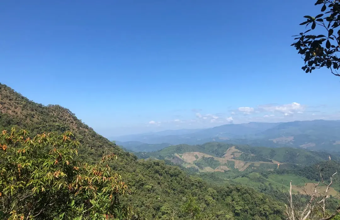
The landscape becomes particularly dramatic toward the western side of the park, where the mountains continue toward the Thailand–Myanmar border region. The park is therefore part of a much larger ecological and geographical landscape rather than an isolated mountain.
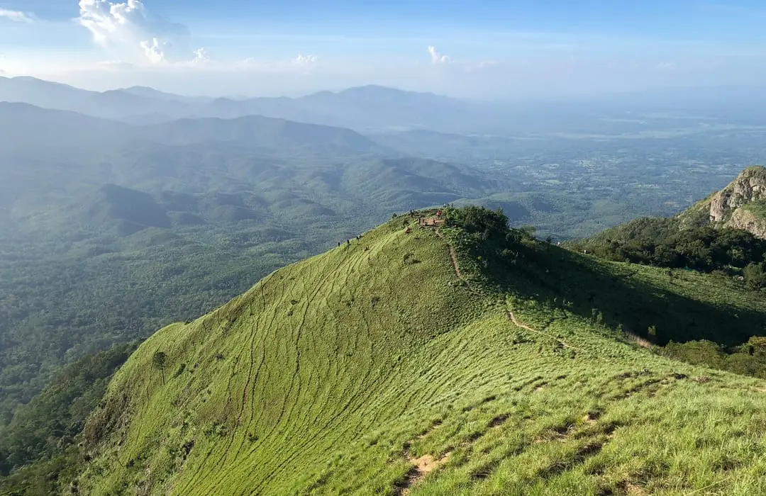
Unlike a destination such as Doi Inthanon, where a single summit dominates the landscape, Khun Phawo is better understood as a network of ridges. The mountains rise and fall continuously. One ridge becomes another. A stream cuts through a valley. A waterfall appears where the terrain suddenly drops.
Forest hiking + waterfall exploration + birdwatching + slow mountain travel.
A Forest of Many Types
Khun Phawo is notable for the diversity of forest types found across its elevation and moisture gradients.
- Moist evergreen forest
- Found particularly in wetter valleys and areas with high moisture. This forest is dense, shaded and rich in vines, ferns, mosses and epiphytes.
- Dry evergreen forest
- Occurs in areas that experience a stronger seasonal dry period. These forests can remain relatively green even when surrounding vegetation begins to dry.
- Hill evergreen forest
- Higher and cooler areas support forest communities adapted to elevated conditions. Mist and humidity can create a very different atmosphere from the lower valleys.
- Mixed deciduous forest
- A seasonal forest type where some trees shed their leaves during the dry season, creating a dramatically different landscape between wet and dry periods.
- Deciduous dipterocarp / dry forest
- Drier slopes can support open woodland communities dominated by deciduous trees. These areas are particularly important in understanding the ecological diversity of the park.
The Trees of Khun Phawo
The park supports a mixture of northern and western Thai forest species. Reported vegetation includes teak, Afzelia, Xylia, Dipterocarpus, Terminalia, Lagerstroemia, Lithocarpus, Indian mahogany, bamboo, rattan, palms, orchids, ferns, mosses and climbing plants.
One particularly interesting aspect of Khun Phawo’s flora is the mixture of plants associated with northern, western and wetter forest environments. Local ecological sources also report plants with stronger associations to wetter regions of Thailand, demonstrating the transitional character of this mountain forest.
A New Botanical Discovery in 2026
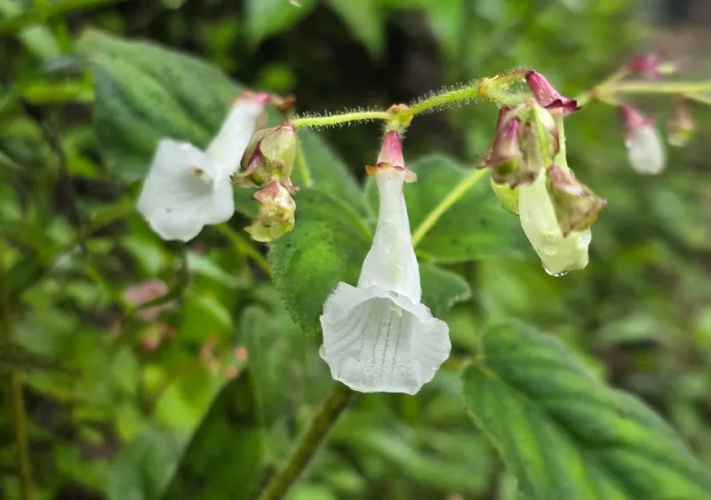
Khun Phawo became even more significant from a botanical perspective in 2026. On 20 August 2026, the Department of National Parks announced the discovery of two plant species new to science from Khun Phawo National Park. They belong to the Gesneriaceae family, genus Didymocarpus.
- Khun Phawo white bell — Didymocarpus niveus
- The species name niveus refers to its snow-white flowers. It is a small herb that can grow on soil or rock and reaches approximately 25 cm in height. Its tubular flowers are approximately 3.5 cm long and white.
- Muang Sri Anusan — Didymocarpus vilaiwaniae
- This species produces vivid purple flowers and was named in honour of Associate Professor Dr. Vilaiwan Anusarnsunthorn, formerly of Chiang Mai University’s Department of Biology.
Both species were formally published in the Thai Forest Bulletin (Botany), Volume 54(2), 2026, and were provisionally assessed as Data Deficient (DD) because further population and distribution surveys are required.
Even in a national park established more than a decade ago, the forest is still capable of revealing species previously unknown to science.
Khun Phawo Waterfall
น้ำตกขุนพะวอ
The park’s signature natural attraction is Namtok Khun Phawo. It is a substantial waterfall dropping through approximately 70–90 metres, generally described as a two-tier waterfall. Water flows throughout the year.
The waterfall is reached by a 2.8-kilometre walking route from the park headquarters. The trail follows the mountain landscape and provides opportunities to experience the forest rather than simply arriving at a roadside viewpoint.
As the path climbs and descends through the forest, the landscape opens periodically toward the surrounding mountains. On clear days, the route can provide views toward the Myanmar side of the borderland landscape. The trail is also known as a good area for birdwatching.
Forest + ridge + waterfall + distant mountain view.
This combination makes the walk one of the most representative experiences of Khun Phawo. It is not a completely flat recreational walk. Travellers should expect genuine mountain terrain.
Huai Krathing Waterfall
น้ำตกห้วยกระทิง
Namtok Huai Krathing is another important waterfall in the park. It is approximately 40 metres high and is associated with Ban Huai Krathing in Phra That Subdistrict, Mae Ramat. From the access point near the village, visitors continue on foot for approximately 700 metres. The waterfall normally has water throughout the year.
Its character is different from Khun Phawo. Where Khun Phawo is strongly associated with the park headquarters and a longer forest trail, Huai Krathing offers a more localised waterfall experience connected to the surrounding community.
Confirm current opening status before travel — this waterfall has appeared on DNP seasonal-closure lists.
Pa Mak Waterfall
น้ำตกป่าหมาก
Namtok Pa Mak is one of the more unusual waterfalls in Khun Phawo. It is a limestone waterfall, with water emerging from underground or rock fissures before flowing onward and eventually dropping approximately 50 metres. There is also a cave beneath the waterfall, reported to extend approximately 200 metres.
The waterfall is located around Ban Pa Mak in Phawo Subdistrict, Mae Sot District. The approach has historically been difficult, particularly during the rainy season, and access conditions can change.
Pa Mak should not be presented as an easy roadside attraction. It belongs to the more adventurous side of Khun Phawo.
Pha Thewa Waterfall
น้ำตกผาเทวะ
Namtok Pha Thewa is associated with the park’s nature-trail landscape and is described in local park information as a waterfall of approximately 150 metres. It is one of the park’s most dramatic vertical waterfall features, set within forest rather than an urbanised tourist environment.
That gives Pha Thewa a different character: large-scale natural scenery without large-scale tourism infrastructure. Because detailed current access information is less consistently documented than for Khun Phawo Waterfall, it is best treated as a park attraction whose trail and access should be confirmed locally before departure.
Smaller Forest Waterfalls
- Thung Nang Khruan Waterfall · น้ำตกทุ่งนางครวญ
- A smaller forest waterfall characterised by multiple low cascades. Rather than one enormous drop, the water moves through a series of small steps within a shaded forest setting — small-scale forest water rather than spectacular waterfall tourism.
- Phueng Luang Waterfall · น้ำตกผึ้งหลวง
- The Department of Mineral Resources lists Phueng Luang among the geological and natural sites surveyed in Tak, confirming its location in the Sam Muen / Sam Muen forest landscape associated with Khun Phawo. As with several of the park’s more remote waterfalls, it is better understood as part of the wider natural resource rather than as a highly developed visitor attraction.
Huai Mae Lamao and the Watershed
ห้วยแม่ละเมา
One of Khun Phawo’s most important waterways is Huai Mae Lamao. The stream originates in the mountain forest and passes through a landscape that historically supported local communities and transportation routes. The upper watershed remains heavily forested.
The stream also provides opportunities for water-based recreation in suitable sections, including rafting activities documented by local tourism information. The character of the activity is strongly dependent on rainfall, water level, current speed, seasonal conditions and local safety regulations. River activities should only be undertaken when officially permitted and under appropriate local supervision.
Documented waterways associated with the park include Huai Mae Lamao, Huai Mae Charao, Huai Phawo, Huai Mae Kasa, Huai Mae Kit Luang, Huai Pha So, Huai Sa Muen Luang, Huai Samae and Huai Mae Ramat. These streams eventually descend toward agricultural and settlement areas around Mae Sot and Mae Ramat.
Forest captures rainfall. Roots stabilize the soil. Streams collect water.
Mountain water eventually moves toward communities and agricultural land. Khun Phawo is an important upstream water-storage landscape.
Wildlife
Khun Phawo provides habitat for a wide variety of forest wildlife. Reported species include barking deer, wild boar, bears, langurs, gibbons, flying squirrels, squirrels, tree shrews, rabbits, civets, Asiatic golden cat, wild junglefowl, cobras, king cobras, other reptiles and numerous forest birds.
These are reported species associated with the park, not animals that visitors should expect to see on every visit.
The correct way to experience Khun Phawo wildlife is not “come here to see a particular animal.” It is: enter a forest where wildlife still has habitat.
Birdwatching
Birdwatching is one of the park’s strongest low-impact activities. A professional bird survey conducted in March 2004 recorded more than 100 bird species in the park. The headquarters area and the trail toward Namtok Khun Phawo were identified as particularly suitable observation areas.
The forest environment provides opportunities to observe forest songbirds, bulbuls, drongos, barbets, woodpeckers, junglefowl, raptors, flycatchers, leafbirds and other resident and seasonal species.
Promising areas include headquarters, forest edges, the Khun Phawo Waterfall trail, stream corridors, mixed forest and higher ridges. The ideal approach is to arrive early — before the forest becomes warm and active with human movement.
Birdwatching here is particularly suited to travellers who enjoy quiet observation rather than attraction collecting.
The History of Phawo
The name Khun Phawo is inseparable from the historical figure known locally as Phawo or Chao Pho Phawo.
According to local historical tradition, Phawo was a Karen warrior and frontier officer associated with Mae Lamao during the reign of King Taksin the Great. The tradition says that he was appointed to protect the Mae Lamao frontier and monitor possible incursions from the west. In 1775, he is traditionally remembered as having led a small force against Burmese troops at the Mae Lamao frontier and died in the fighting. This story has become deeply embedded in the historical memory of Mae Sot and surrounding communities.
This distinction matters. The story of Phawo is strongly established in local historical tradition and community memory, but individual details of the narrative should not automatically be presented as independently verified archival fact.
Local historical tradition identifies Phawo as a Karen warrior appointed as a frontier officer at Mae Lamao during the reign of King Taksin the Great. He is remembered for fighting Burmese forces in 1775 and dying in the battle.
That preserves the cultural significance without turning every element of oral history into an absolute historical claim.
Mae Lamao — A Frontier Landscape
The significance of Khun Phawo becomes clearer when viewed through the history of Mae Lamao. Western Tak was historically a frontier landscape. Mountain passes connected Thailand and Myanmar, and the terrain around Mae Lamao became strategically important for military movement, communication, trade, frontier surveillance and movement between western and central Thailand.
The mountains were therefore not merely obstacles. They were corridors. Who controlled the passes controlled movement through the frontier.
The park was originally associated with the proposed Mae Kasa National Park. The name was later changed to Khun Phawo National Park in recognition of Phawo and his role in the historical memory of the Mae Lamao frontier. This is why the park’s name is particularly meaningful. It is not simply a geographical name. It connects landscape, community, frontier and history.
The Karen Connection and the Borderland
Local historical research describes Phawo as a Karen leader and warrior, and emphasises the long-standing presence of Karen communities in the Mae Sot–Mae Ramat mountain landscape. This is an important part of understanding western Tak. The forest was never an empty wilderness. It has long been a lived landscape containing communities, agricultural areas, forest knowledge, traditional routes, spiritual beliefs, local leaders and historical battlefields.
Khun Phawo sits within a landscape shaped by the proximity of Myanmar. From elevated parts of the park and certain hiking routes, the western horizon can open toward the mountain landscape on the Myanmar side.
This gives Khun Phawo a distinctive atmosphere. It is simultaneously a national park, a watershed, a mountain forest, a historical frontier and a borderland landscape.
The View from the Forest
One of the more memorable aspects of the Khun Phawo trail is that the forest does not completely isolate the traveller. At certain points, the ridge opens. The mountains become visible. The western horizon extends toward Myanmar. The landscape suddenly becomes much larger than the trail itself.
This is where Khun Phawo works particularly well as a ThailandLover destination. It gives travellers a sense of place, rather than simply giving them another waterfall photograph.
The park has a nature-trail system associated with the headquarters and waterfall areas. The trail environment includes steep slopes, forest ridges, streams, small cascades, birds, wildflowers, changing vegetation and mountain viewpoints. The route toward Namtok Khun Phawo is approximately 2.8 km on foot.
One of the lesser-known pleasures of Khun Phawo is seasonal botanical change. After the rainy season, as the landscape transitions toward the cooler season, flowering plants can appear along forest edges and trails. The change is subtle. It is not a manicured flower garden. It is wild seasonal vegetation emerging naturally from the forest — exactly the kind of experience that rewards slow travel.
Climate
Khun Phawo receives strong seasonal influence from the monsoon climate of western Thailand. Moisture from the broader Andaman-facing monsoon system interacts with the mountain landscape. As humid air rises over the mountains, rainfall can increase. The result is a forest environment that can remain remarkably lush compared with many inland areas of northern Thailand.
Mountain + moisture + elevation + watershed.
- Rainy season
- The forest becomes dense and intensely green. Waterfalls are generally at their most powerful. Mountain roads and trails can become slippery, and some remote attractions may become inaccessible.
- Cool season
- Generally the most comfortable period for hiking. Morning temperatures can feel distinctly cool in the higher forest, and mist can develop around the ridges. One of the best periods for hiking, birdwatching, camping and landscape photography.
- Hot / dry season
- Lower areas become warmer and some deciduous forest loses its leaves. Water levels can decrease. Visibility can sometimes improve on clear mornings, although smoke and haze can affect northern Thailand during the burning season.
Camping in Khun Phawo
Camping is one of the park’s established activities. The park provides camping facilities, and local tourism information also documents accommodation and camping capacity at the headquarters area.
For travellers, camping changes the experience completely. Instead of visiting the waterfall and leaving, you remain inside the mountain landscape. Morning becomes mist, birds, cool air and forest sounds. Night becomes darkness, insects, distant forest sounds and mountain silence.
The park also promotes camping at Khun Phawo National Park Protection Unit Kh.P.4, known locally as Noen Phitsawong / เนินพิศวง. It is associated with the park’s viewpoint and camping experience — a quieter alternative to conventional accommodation.
Getting There
There are several approaches to Khun Phawo. One commonly documented route is from Tak via the main northern road network toward Mae Ramat and then Highway 1175. Local park information gives a route from Tak via Phahonyothin Highway toward Ban Tak, then Highway 1175 for approximately 70 km, with a total journey of roughly 95 km to the park area.
Another practical approach is through Mae Ramat / Mae Sot. Exact travel time depends heavily on the starting point, road conditions and destination within the park.
- Highway 1175
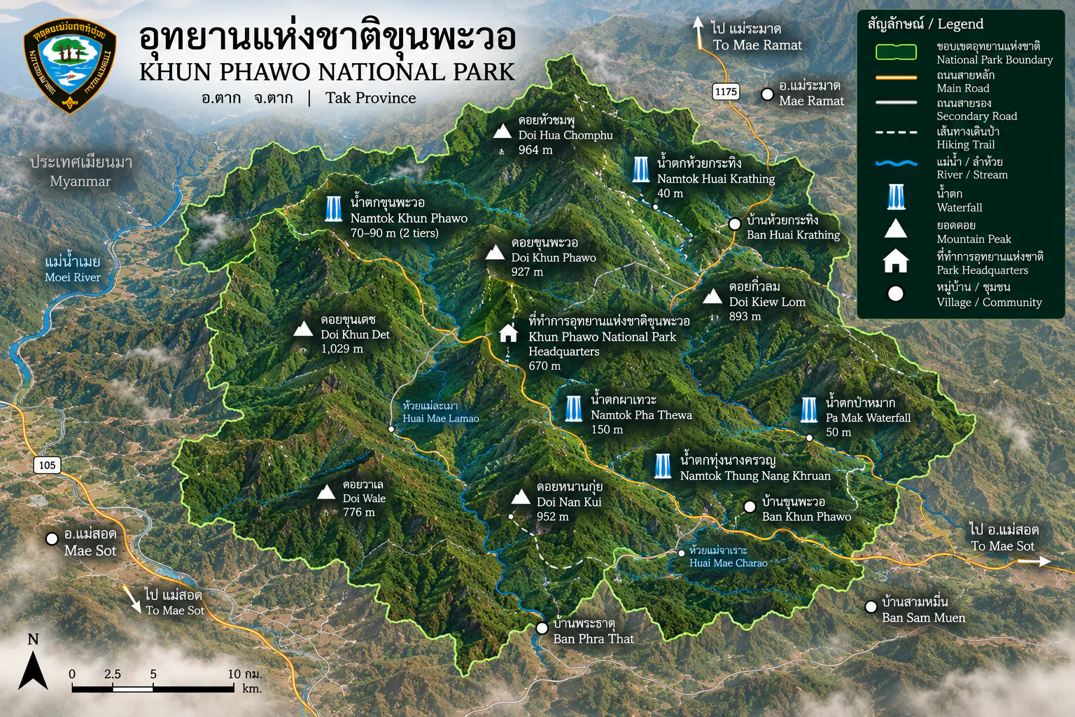
- An important access route in the northern part of the park, connecting the park landscape with the Mae Ramat side of Tak. On the ThailandLover map, treat it as a regional access road rather than a road running through every attraction in the park.
- Highway 105
- The principal western Tak corridor connecting Mae Sot and Mae Ramat toward the northern borderland. It provides the broader regional connection between the park and the Mae Sot urban area, and forms an important part of a western Tak road-trip network.
- With Mae Sot
- Mae Sot provides accommodation, restaurants, shopping, cultural attractions, transport connections and access toward Myanmar. Khun Phawo then provides the opposite experience: forest, mountains and silence. This contrast is one of the strongest ways to experience the destination.
- With Mae Ramat
- An even more natural gateway because the park sits within the district’s broader mountain landscape. The route moves from town to agricultural landscape to foothills to mountain forest. That transition is itself part of the experience.
- With Mae Lamao
- Essential for travellers interested in the historical side of the park — where Phawo’s story, frontier history and mountain geography come together. The name of the park becomes much more meaningful once the traveller understands the historical role of Mae Lamao.
Photography
Khun Phawo offers several distinct photographic subjects.
- Waterfalls
- Best around Khun Phawo, Huai Krathing and Pa Mak — when those sites are open and safely accessible.
- Landscape
- Best from ridges, open forest edges, viewpoints and elevated trails.
- Forest
- Look for mist, backlit leaves, moss, streams, tree trunks, ferns and seasonal flowers.
- Cultural / historical
- The Phawo story and Mae Lamao frontier landscape add an important human dimension.
The Park Is Not Just About Waterfalls
Tourism directories often introduce Khun Phawo primarily through its waterfalls. From an editorial perspective, that undersells the park.
- 1
- Mountain forest
- 2
- Watershed
- 3
- Biodiversity
- 4
- Waterfalls
- 5
- History
- 6
- Community
The waterfalls are what visitors see. The forest is what makes them possible.
Current Conservation Story
Khun Phawo remains an actively managed protected forest. In August 2026, DNP enforcement officers reported a seizure involving illegally stored processed Afzelia / rosewood-type timber (ไม้ประดู่) in the park, with reported damage value exceeding THB 200,000.
This is a useful reminder that protected-area management is not abstract. The park is still dealing with illegal logging, forest protection, wildlife protection, fire management, boundary issues, human pressure and sustainable tourism.
A national park is protected because the forest still has value.
Current Access & Seasonal Closures
This section requires particular caution. Older TAT national-park status information listed Khun Phawo as open, but DNP’s more recent seasonal-closure documentation has also identified specific attractions that may be closed.
A DNP seasonal-closure schedule lists Huai Krathing Waterfall, Pa Mak Waterfall, Huai Mae Lamao and Mae Lamao Cave as subject to indefinite closure in the referenced management schedule.
These locations should not be marketed as currently accessible attractions without checking directly with the park.
This is particularly important for Pa Mak because its access is already difficult during wet conditions.
Entrance Fees
Khun Phawo is classified in National Park Group 2 under the DNP fee schedule. These are the published DNP rates for Group 2 national parks.
- Thai adult
- 40 THB
- Thai child
- 20 THB
- Foreign adult
- 200 THB
- Foreign child
- 100 THB
National-park fees and temporary exemptions can change. For example, DNP announced nationwide free admission for Thai citizens on 3 June 2026 as a special one-day measure. Confirm current collection before travelling.
Who Should Visit Khun Phawo?
Perfect for
- Nature lovers
- Birdwatchers
- Landscape photographers
- Waterfall enthusiasts
- Campers
- Independent travellers
- Mountain-road travellers
- Travellers interested in western Thai history
- Visitors exploring Mae Sot and Mae Ramat
- Travellers looking for quieter national parks
Not ideal for
- Travellers seeking luxury facilities
- Visitors wanting a highly developed tourist park
- Travellers who dislike mountain roads
- Travellers expecting every waterfall to be accessible
- Visitors looking for a short roadside attraction
- Travellers who want predictable wildlife sightings
The Ideal Khun Phawo Travel Style
Do not rush. Do not attempt to see every waterfall in one day. Do not treat the park as a checklist.
Arrive → walk → listen → watch → stay overnight → explore slowly.
Khun Phawo rewards this approach.
A suggested 2-day experience
- Day 1 — Mae Sot → Mae Ramat → Khun Phawo
- Travel through the western Tak landscape. Arrive at the park. Settle into the camping or accommodation area. Explore the surrounding forest. Watch the sunset from an appropriate viewpoint. Stay overnight.
- Day 2 — Khun Phawo Waterfall → forest → Mae Ramat
- Start early. Walk the approximately 2.8 km trail toward Namtok Khun Phawo. Spend time in the forest. Return to headquarters. Continue toward Mae Ramat or Mae Sot.
This is a better experience than trying to force multiple remote waterfalls into one itinerary.
Responsible Travel
Khun Phawo is a watershed forest. That means every visitor has a direct relationship with the health of the landscape.
Do
- Stay on designated trails
- Follow park instructions
- Take all waste out
- Keep noise low
- Respect local communities
- Respect cultural sites
- Use authorised camping areas
- Carry sufficient drinking water
- Check weather before hiking
- Follow temporary closure notices
- Report illegal activity to park officials
Do not
- Feed wildlife
- Collect plants
- Collect rocks or geological specimens
- Enter closed waterfalls or trails
- Enter caves without authorisation
- Light fires outside designated areas
- Leave food waste behind
- Use loud music
- Approach wildlife
- Assume a waterfall is safe because water appears calm
Why Khun Phawo Matters
- As a natural landscape
- It protects a large mountain forest and watershed.
- As a biodiversity reserve
- Its forests provide habitat for birds, mammals, reptiles and plants, including two plant species formally described as new to science in 2026.
- As a cultural landscape
- Its name preserves the memory of Phawo and the historical Mae Lamao frontier.
Together, these three layers make the park much more interesting than its relatively low international profile might suggest.
Frequently Asked Questions
- What is Khun Phawo National Park?
- Thailand’s 115th national park, established on 23 December 2009. It covers 247,957 rai / 396.73 km² across Mae Ramat and Mae Sot districts in Tak, protecting a western mountain forest, watershed streams and waterfalls including Namtok Khun Phawo.
- Where is it?
- Western Tak Province, across Mae Ramat and Mae Sot, in the Thanon Thong Chai mountain region near the Thailand–Myanmar borderland. Gateways are Mae Ramat and Mae Sot, with Highways 1175 and 105 as the main regional roads.
- How do I reach Khun Phawo Waterfall?
- Namtok Khun Phawo is reached by an approximately 2.8 km walking trail from park headquarters. It is a two-tier waterfall of about 70–90 metres with water throughout the year. Expect genuine mountain terrain.
- Are all waterfalls currently open?
- Not necessarily. A DNP seasonal-closure schedule has listed Huai Krathing Waterfall, Pa Mak Waterfall, Huai Mae Lamao and Mae Lamao Cave as subject to indefinite closure. Confirm current access directly with the park before travel.
- What are the entrance fees?
- Khun Phawo is classified in National Park Group 2. Published DNP rates are Thai adult 40 THB, Thai child 20 THB, foreign adult 200 THB and foreign child 100 THB. Fees and temporary exemptions can change.
- Who was Phawo?
- Local historical tradition identifies Phawo as a Karen warrior appointed as a frontier officer at Mae Lamao during the reign of King Taksin the Great. He is remembered for fighting Burmese forces in 1775 and dying in the battle. Individual details should be treated as community tradition rather than independently verified archival fact.
- When is the best time to visit?
- The cool season is generally the most comfortable for hiking, birdwatching, camping and landscape photography. The rainy season makes waterfalls more powerful but trails and remote attractions can be slippery or inaccessible.
Explore More of Tak
- Taksin Maharat National Park
- Tak’s highland forest closer to the provincial heartland — giant trees, cool air and a different side of the same province.
- Lan Sang National Park
- Waterfalls and forest near Tak town — an easy pairing if you are travelling the western highway.
- Namtok Pha Charoen National Park
- A multi-tiered waterfall landscape in Tak for travellers continuing toward Mae Sot.
- Mae Moei National Park
- Border-country forest along the Moei River — wilder Tak for travellers heading west.
- Doi Soi Malai National Park
- Petrified wood and western Tak geology — another layer of the province’s deep-time landscape.
- Nature & Parks
- More mountains, forests and protected landscapes across ThailandLover’s collection.
Location
Find Khun Phawo National Park
Mae Ramat and Mae Sot, Tak · gateways via Highway 1175 and Highway 105