

National Park · Tak
Mae Moei National Park
อุทยานแห่งชาติแม่เมย
Mountain Forests, Mist & the Moei Frontier
Tha Song Yang · Sea of Mist · Mae U-Su Cave
Discover the quiet side of western Thailand — forested ridges, sunrise above the clouds and the hidden limestone world of Mae U-Su Cave.
Where the Landscape Feels Like a Threshold
There are places in Thailand where the landscape feels less like a destination and more like a threshold. Mae Moei National Park is one of them.
Set among the mountain ranges of Tha Song Yang District in western Tak, the park stretches toward the Thai–Myanmar frontier. The Moei River forms part of that natural border. Forested ridges rise above deep valleys and headwater streams. A series of mountain viewpoints open toward layers of distant hills and morning mist.
Mae Moei is best known for its sea of mist, particularly around Mon Kiew Lom, Mon Kru Ba Sai and Mon Poon Suda. But it is more than a collection of viewpoints. The landscape also holds limestone terrain, the remarkable Mae U-Su Cave, important headwaters, forest ecosystems and long-established local routes through the mountains.
This is not a national park designed around a single spectacular landmark. It is a place to slow down, stay overnight, wake before sunrise and watch the mountains gradually emerge from the mist.
Mae Moei is at its best when experienced as a mountain landscape rather than a checklist of attractions.
At a Glance
- 185.28 km²
- Published park area — 115,800 rai.
- 20 May 1999
- Formal establishment by Royal Decree.
- ~1,250 m
- Highest elevation. Average around 680 m.
- Sea of mist
- The signature, especially at sunrise.
- Mae U-Su
- A limestone water cave — seasonal access only.
- Official Name
- Mae Moei National Park
- Thai Name
- อุทยานแห่งชาติแม่เมย
- Province
- Tak
- District
- Tha Song Yang
- Key subdistricts
- Mae Usu & Mae Song
- Area
- 185.28 km² / 115,800 rai
- Established
- 20 May 1999 · Royal Gazette, Vol. 116, Part 40 Kor
- Landscape
- Mountain ranges, forest valleys, limestone and river systems
- Elevation
- Average ~680 m · highest ~1,250 m
- Signature experience
- Sea of mist at mountain viewpoints
- Geological highlight
- Mae U-Su Cave
- Major waterways
- Moei · Mae Usu · Mae Song · Mae Salid Luang
- Best-known viewpoints
- Mon Kiew Lom · Mon Kru Ba Sai · Mon Poon Suda
- Longer hiking highlight
- Mon Pui Mok
- Best suited to
- Nature lovers, photographers, campers, hikers and slow travellers
- Nearest gateway
- Mae Sot / Tha Song Yang
- Park contact
- 061-352-3703 · Tak 63150
Where Is Mae Moei National Park?
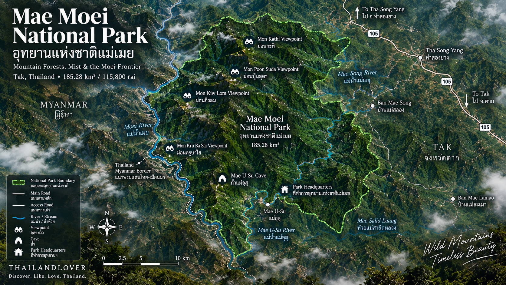
Mae Moei lies in Tha Song Yang District, Tak Province, in western Thailand. The park covers parts of Mae Usu and Mae Song subdistricts, in a mountainous landscape close to the Thai–Myanmar frontier.
Its western edge is closely associated with the Moei River, an important natural boundary between Thailand and Myanmar in this part of the country. Visitors are not simply entering a northern mountain forest. They are travelling into one of Thailand’s western frontier landscapes.
The approach is part of the experience. From the main north–south highway, the road turns into the mountains toward the park headquarters and its elevated viewpoints. There is relatively little flat land inside the park. Ridges, valleys and steep mountain terrain dominate instead.
The Landscape
Ridges, valleys and very little level ground
The park’s average elevation is around 680 metres. Its highest point is approximately 1,250 metres. That difference shapes the character of Mae Moei. Lower valleys support waterways and warmer forest. As the terrain rises, the landscape becomes increasingly exposed to cooler mountain conditions, particularly in the cool season.
What you move through is a landscape of long mountain ridges, forest-covered slopes, narrow valleys, seasonal streams, limestone formations and elevated viewpoints — and, when the weather agrees, mist-filled valleys.
The park is also an important headwater area. The Mae Song, Mae Usu and Mae Salid Luang systems, together with the Moei River, are among the waterways associated with the landscape. That relationship between mountain, forest and water is one of the defining characteristics of Mae Moei.
The Moei River & the Western Frontier
The park’s name comes from the Moei River, one of the defining geographical features of western Tak. Unlike the major river systems that dominate much of northern Thailand, the Moei is closely associated with the international boundary between Thailand and Myanmar.
At Mae Moei, that creates a distinctive sense of place. The mountain landscape does not end at the park boundary. Across the river lies another country. The ridges and valleys continue into the wider mountainous landscape of the Myanmar frontier.
Forests & Ecology
Mae Moei forms part of the forested mountain landscape of western Thailand. The broader Tak region contains several important forest types. Mae Moei’s terrain supports a mixture of forest environments influenced by elevation, moisture, slope and geology.
The park is particularly important as a watershed landscape. Forested slopes capture rainfall and feed streams that eventually form larger waterways. The Mae Usu, Mae Song and Mae Salid Luang systems are not simply scenic features. They are part of the ecological infrastructure of the region.
The forest also provides habitat for a range of wildlife. Seeing it is never guaranteed. Mae Moei is a natural habitat, not a wildlife park. The appropriate experience is observation rather than expectation: listen for birds, look for tracks, watch the forest edge, and allow the landscape to reveal itself slowly.
Mae U-Su Cave
ถ้ำแม่อุสุ · the underground landscape
If the viewpoints represent the open landscape of Mae Moei, Mae U-Su Cave represents its hidden geological world. Located in Mae Usu Subdistrict, it is a substantial limestone cave associated with the Mae Usu stream.
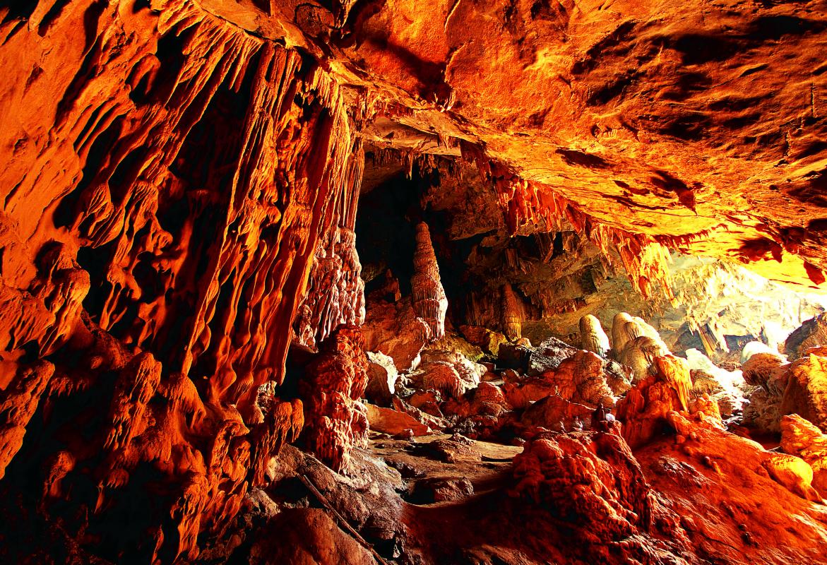
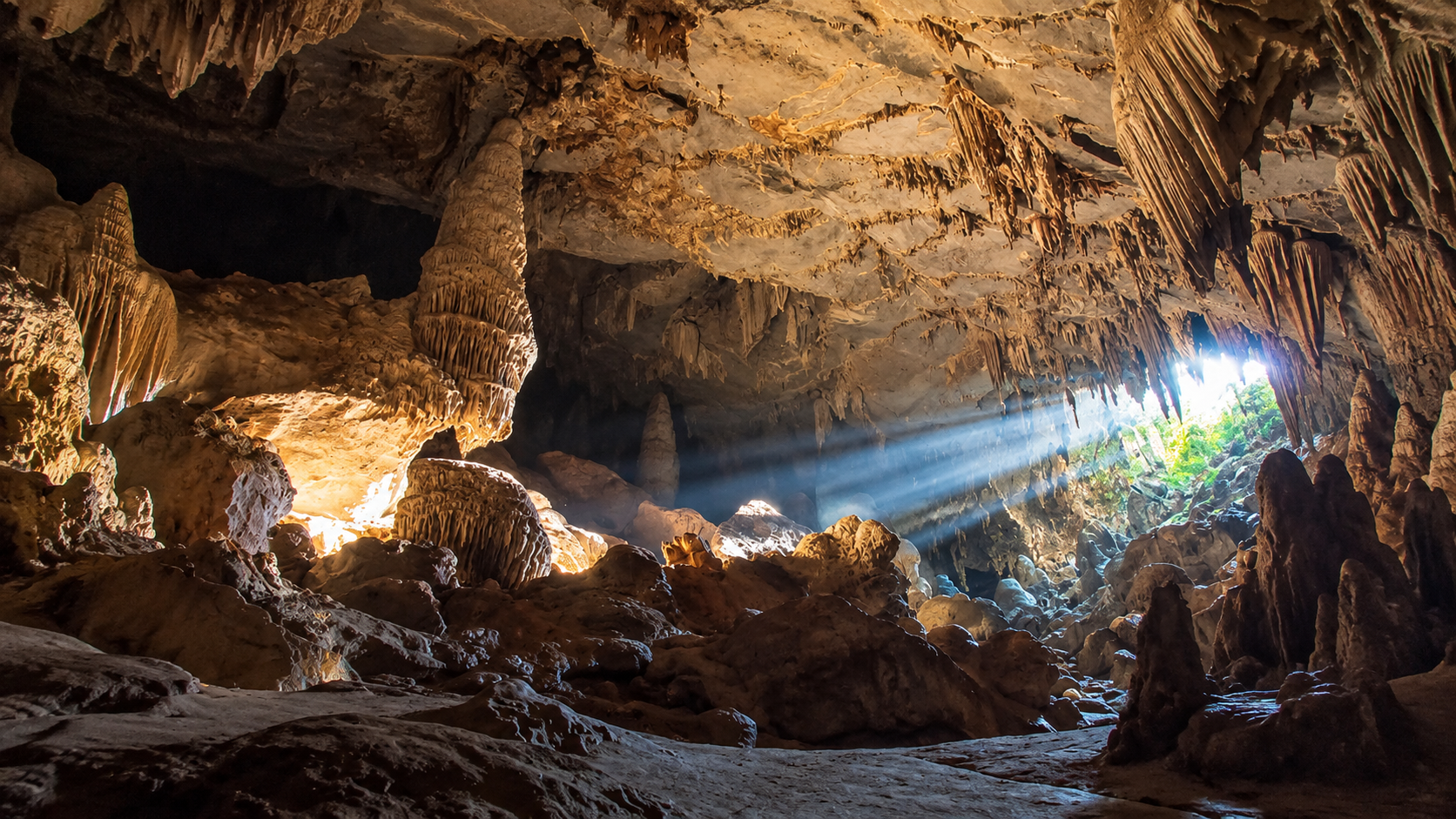
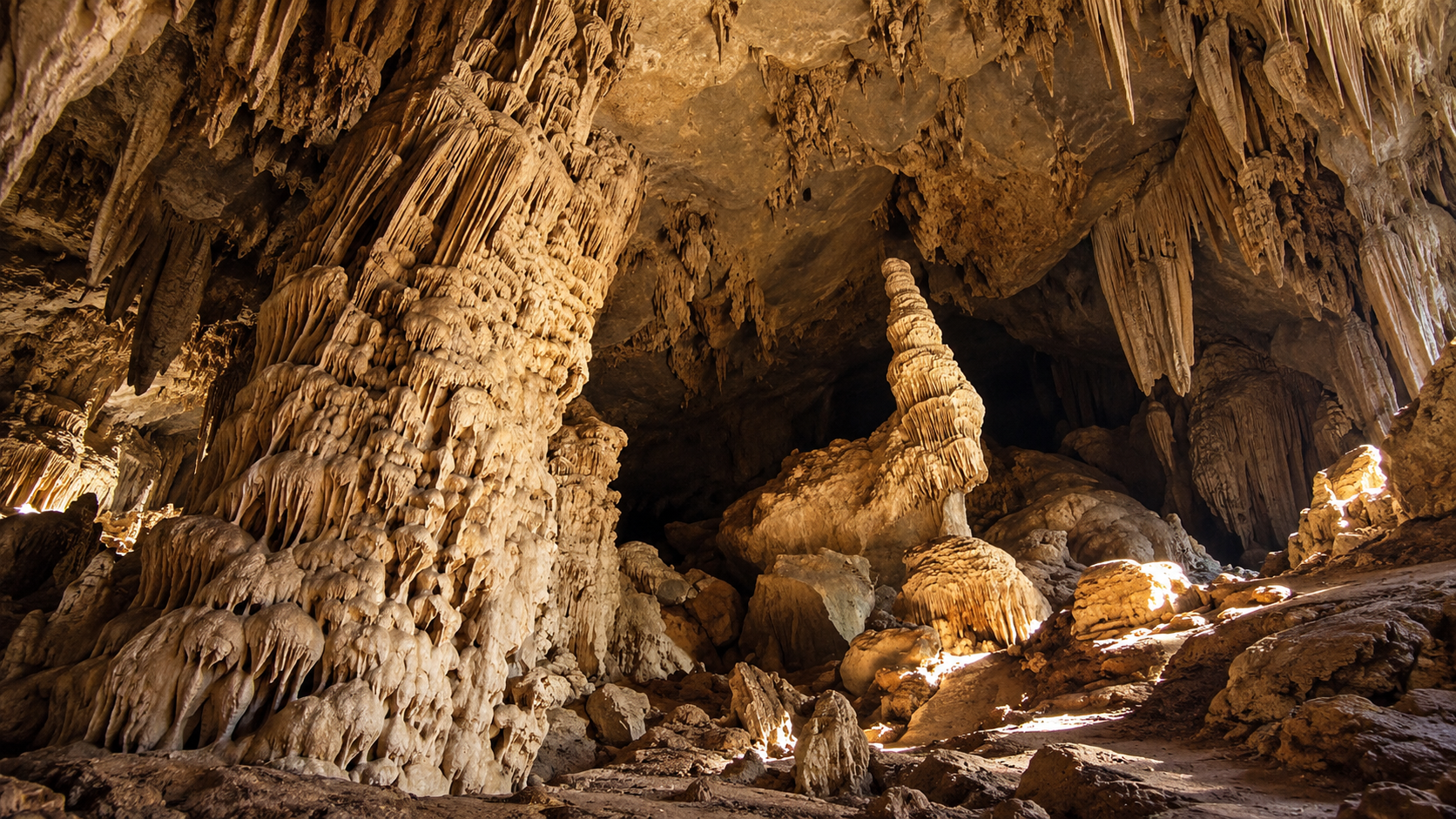
The Department of Mineral Resources describes it as a water cave, where the stream passes through the cave system. Inside are stalactites, stalagmites, columns, flowstone, cave sediments and limestone formations. The cave is particularly impressive because of its large chambers and high ceiling. Natural light enters through openings in the system, producing changing patterns of light and shadow.
The geological setting matters too. The limestone associated with Mae U-Su Cave is marine limestone — a much older geological history than the landscape visible on the surface.
Mon Kiew Lom
The sunrise viewpoint · about 13–14 km from headquarters
Mon Kiew Lom is one of Mae Moei’s signature viewpoints, particularly associated with sunrise and sea-of-mist views. It sits in the mountainous interior and looks across layers of ridges and valleys. Under suitable conditions, low cloud settles into the valleys below and produces the classic sea-of-mist effect.
Compared with some of the park’s longer hiking destinations, the viewpoint has a relatively accessible road connection. Geological information from the Department of Mineral Resources places it within the park and records a broad viewpoint overlooking successive mountain ranges. The distance from headquarters is approximately 13–14 kilometres, depending on the reference point and route.
Arrive before sunrise.
The landscape changes rapidly in the first hour of daylight. Dark ridges become visible. Mist begins to glow. The horizon brightens. The surrounding mountains gradually emerge. That transition is why Mon Kiew Lom is one of Mae Moei’s most photographed locations.
Mon Kru Ba Sai
Mist, mountains & evening light
Mon Kru Ba Sai is another established viewpoint in the park’s main mountain-viewing area, associated with broad mountain views and sea-of-mist conditions. Unlike Mon Kiew Lom, which is especially popular for sunrise, Mon Kru Ba Sai and nearby Mon Poon Suda are well positioned for views toward the western landscape.
That combination is useful if you are staying overnight: sunset at one viewpoint, sunrise at another.
The word Mon is a northern Thai term commonly used for a hilltop or elevated mountain location.
Mon Poon Suda
Mon Poon Suda sits close to Mon Kru Ba Sai. According to the Mae Song Subdistrict local authority, the two viewpoints are approximately 500 metres apart, while Mon Poon Suda is around 7.5 kilometres from the park headquarters.
The viewpoint is named after the photographer Poon Kessamras and his wife Suda, associated with the early photographic recognition of the place. Today its appeal is straightforward: mountains, mist, open sky, and a quieter perspective over the surrounding landscape. It is best experienced together with Mon Kru Ba Sai, not as an isolated stop.
The Viewpoint Behind the Headquarters
One of Mae Moei’s less commercial, and more rewarding, experiences is the viewpoint behind the park headquarters. This is not a roadside photo stop. Local government information describes it at approximately 1,100 metres, with broad views over the sea of mist and the chance to see both sunrise and sunset.
The documented route requires approximately 3–4 hours of walking, with an overnight stay recommended. It is a different type of Mae Moei experience. You are no longer simply driving to a viewpoint. You are entering the mountain landscape.
Mon Pui Mok
About 3.5 km on foot · around 1,171 m
For travellers who want a more active experience, Mon Pui Mok is the hiking-oriented alternative. The Mae Song local authority describes the route as approximately 3.5 kilometres on foot from the park headquarters, with an overnight stay required. The route passes through mountain terrain, with smaller waterfalls and open grassland along the way.
At approximately 1,171 metres, it provides a higher perspective over the surrounding landscape. It suits travellers prepared to walk and spend a night in the mountains, not visitors looking for a quick scenic stop.
Other Mountain Viewpoints
Mae Moei is frequently associated with a wider group of mountain viewpoints, including names such as Mon Kathi, Mon Krathing and Mon Pui Mok. Some of these names appear in older tourism and local references, and the exact access arrangements can change with seasonal management.
For a current ThailandLover guide, the most consistently documented core viewpoints remain:
- Mon Kiew Lom
- Mon Kru Ba Sai
- Mon Poon Suda
- Mon Pui Mok
- The viewpoint behind the park headquarters
That keeps the guide focused on places for which the available geographic information is relatively consistent. Names labelled on the orientation map, including Mon Kathi, should still be checked with the park before you treat them as an open stop.
A Park Built Around Mist
Sea of mist is the visual signature of Mae Moei. It is not a permanent attraction. It depends on moisture, overnight cooling, temperature differences, local topography, wind, cloud formation and recent rainfall.
Mae Moei’s deeply dissected mountain landscape creates many valleys where moist air can accumulate. That is why conditions can change dramatically from one morning to the next. One sunrise may reveal a dense white sea of mist. Another may offer clear mountain ridges. A third may be completely covered by cloud.
That unpredictability is part of the attraction.
When to Visit
- Cool season · November – February
- Best overall for classic Mae Moei experiences: cool temperatures, sunrise, mountain viewpoints, sea of mist, camping, photography and clear mountain views. Early mornings can be cold, particularly at elevated viewpoints. For photographers, the first hour after sunrise is often more rewarding than the moment of sunrise itself, as the changing light reveals the layers of the mountains.
- Hot season · March – April
- Warmer and generally drier. The atmosphere can be less consistently misty, and visibility may vary. More comfortable at lower elevations if you dislike cold-weather camping — and not the strongest season if classic cool-season sea-of-mist photography is the point. Check wildfire and haze conditions before travelling in the dry season.
- Rainy season · May – October
- Substantial rainfall. The mountains become greener and streams more active, but wet-season travel needs more caution. Roads can be slippery, visibility can deteriorate, and cave access is particularly sensitive to water levels. Mae U-Su Cave is subject to seasonal closure. If the cave is your priority, confirm its operating status with the park before departure.
The Best Time of Day
- Sunrise
- The defining time at Mae Moei, and the main event at Mon Kiew Lom. Arriving late means missing the most atmospheric part. Plan to be at the viewpoint before first light.
- Morning
- After sunrise, the mountain layers become increasingly visible. Mist may remain in the valleys for some time. Softer light, and usually a clearer atmosphere than later in the day — one of the best periods for photography.
- Afternoon
- Better for slower exploration, camping and shorter walks. At Mae U-Su Cave, historical geological descriptions note that natural light can enter and create particularly attractive illumination later in the day — if the cave is officially open.
- Sunset
- Mon Kru Ba Sai and Mon Poon Suda are particularly suitable for western-facing mountain views. Sunset here is less about the dramatic sun itself and more about the changing colour of the mountain layers.
Camping at Mae Moei
Mae Moei works particularly well as an overnight destination. The park has accommodation and camping facilities associated with the headquarters area. Published DNP accommodation records include four park houses:
- Mae Moei 101
- Phrai Phiman
- Mae Moei 102
- Chidchon
- Mae Moei 103
- Khu Phruetksa
- Mae Moei 104
- Rim Doi
Published accommodation data lists capacities ranging from four to six people for the individual houses, with the larger units priced at the higher end of the listed range. Availability and operating conditions change. Confirm current availability with the park before travelling.
Getting There
- By car
- The most practical option for most independent travellers. The main approach follows Highway 105, the Mae Sot–Mae Sariang route. From the Tha Song Yang area, turn toward Mae Salid Luang and continue on Route 1267 toward the park headquarters. The final mountain section includes steep terrain.
- The documented approach
- A government tourism source describes the route from Tha Song Yang toward the park as approximately 33 kilometres along Highway 105 to the Mae Salid Luang junction, followed by approximately 11 kilometres on Route 1267 toward the headquarters. Distances from Mae Sot or Tak should be treated as route-dependent, not fixed figures.
- From Mae Sot
- The most practical major urban gateway for western Tak. Follow Highway 105 north toward Tha Song Yang and continue toward the park access route. This is a mountain journey, not a short city-to-park transfer. Allow extra time for mountain roads, weather, stops, photography and slow traffic.
- By public transport
- Possible, and considerably less convenient. The elevated viewpoints and dispersed attractions make independent road access particularly useful. Without a car, arrange local transportation from Tha Song Yang or Mae Sot in advance rather than relying on spontaneous connections.
Road Conditions & Driving Notes
Mae Moei is not the place to drive aggressively.
The mountain approach includes gradients, curves, narrow sections, limited roadside space, reduced visibility in mist, and potentially slippery surfaces during rain. In the early morning, fog can substantially reduce visibility. If you are driving to a viewpoint before sunrise, allow considerably more time than the daytime journey.
A vehicle with good tyres and brakes is more important than a powerful engine.
Hiking & Outdoor Activities
Mae Moei suits travellers who enjoy combining road travel with short and moderate mountain walks.
- 1 · Sea-of-mist viewing
- The park’s signature activity.
- 2 · Sunrise photography
- Especially around Mon Kiew Lom. Be there before first light.
- 3 · Sunset photography
- Particularly around Mon Kru Ba Sai and Mon Poon Suda.
- 4 · Camping
- A natural fit for the elevated landscape around the headquarters.
- 5 · Longer hiking
- Routes toward Mon Pui Mok and the viewpoint behind the headquarters are the more immersive version of the park.
- 6 · Cave exploration
- Mae U-Su Cave, when officially open, is the park’s most distinctive geological experience.
- 7 · Nature observation
- Suitable for birdwatching and wildlife observation. Sightings are never guaranteed.
A Note on Wildlife
A wildlife habitat and forest ecosystem — not a guaranteed wildlife destination.
Mae Moei is a protected forest, not a wildlife-viewing enclosure. Historical descriptions mention species including muntjac, wild boar, barking deer, civets, macaques, gibbons, squirrels, junglefowl, hornbills, and reptiles and amphibians. Those records are not a promise that you will see them.
If you see an animal: stop, keep your distance, do not feed it, do not chase it, and let it disappear into the forest.
Geology
Mae Moei is particularly interesting because its landscape contains both mountain terrain and limestone formations. The most obvious expression of the limestone landscape is Mae U-Su Cave.
The Department of Mineral Resources identifies the cave as a limestone cave associated with ancient marine deposits, and documents features including stalactites, stalagmites, columns and flowstone. The cave is more than a scenic attraction. It is a geological record of an ancient marine environment that has subsequently been uplifted, fractured, weathered and shaped by water.
That is one of the strongest reasons Mae Moei deserves to be viewed as a landscape destination rather than simply a “sea of mist” viewpoint.
The Cultural Landscape
Mae Moei should also be understood within the wider human landscape of Tha Song Yang. The mountains are not an untouched wilderness separated completely from local communities. People have lived, travelled and farmed within this mountainous frontier landscape for generations. Around Mae U-Su, for example, local communities have historically used land surrounding the cave for agriculture.
This creates a more complex conservation landscape than the simple idea of “forest versus people.” For responsible travellers, that means respecting local communities, agricultural areas, village roads, cultural practices, local guides and restrictions around protected areas. The landscape is shared.
Responsible Travel
Mae Moei rewards visitors who travel lightly.
- Do not leave food at viewpoints. Food waste attracts wildlife and changes animal behaviour.
- Do not play loud music. The mountain landscape is one of the park’s greatest assets.
- Take rubbish with you — especially plastics, food packaging and cigarette waste.
- Do not enter closed caves. A closure is a safety and conservation decision, not an inconvenience to negotiate around.
- Do not walk outside designated routes. Mountain terrain can be unstable, and visibility can deteriorate rapidly.
- Do not collect rocks or cave formations. Limestone formations grow extremely slowly.
- Avoid single-use plastic where practical. Carry a reusable bottle and minimise packaging.
- Respect local communities. Do not photograph people without permission, particularly in villages and residential areas.
- Respect the border landscape. Do not approach restricted areas or cross unofficially.
Safety
Mae Moei is beautiful, but it is not a soft-adventure destination everywhere. Take particular care with:
- Steep mountain roads, slippery surfaces and fog
- Heavy rain, flash flooding and stream crossings
- Cave conditions, and any official closure
- Limited mobile connectivity in some areas
- Cold temperatures at night
- Remote hiking routes
For longer hikes, contact the park beforehand and follow current requirements regarding guides, registration and overnight stays. For Mae U-Su Cave, never enter during closure periods or when water levels are unsafe.
What Mae Moei Is — and Is Not
- Mae Moei is for you if you enjoy
- Mountains, mist, camping, sunrise, photography, quiet landscapes, road trips, nature, caves, slower travel, and places that still feel relatively remote.
- It may not be for you if you want
- A highly developed resort, shopping, nightlife, extensive restaurants, easy public transportation, a guaranteed sea of mist, or a large number of commercial attractions.
Mae Moei’s appeal comes from the opposite qualities. It is relatively quiet. It is mountainous. It requires some effort. And that effort is part of the experience.
How Long Should You Stay?
- One day
- Possible, but not ideal. A day trip can cover a viewpoint or two, depending on route and timing. Travelling all the way into Mae Moei simply for a quick photograph misses much of the character of the park.
- One night
- Recommended. Arrive in the afternoon, explore the surroundings, watch sunset, camp or stay overnight, wake before sunrise, visit Mon Kiew Lom, and continue exploring the next morning. For most visitors, one night is the minimum that makes the journey feel worthwhile.
- Two nights
- Best for slower travellers. More flexibility for multiple viewpoints, hiking, camping, weather changes, Mae U-Su Cave when open, photography, and simply enjoying the mountains. This is the version of Mae Moei that ThailandLover would recommend.
A ThailandLover Itinerary
Into the mountains, then the Mae Moei morning
- Day 1 · Morning
- Depart Mae Sot or Tha Song Yang. Continue along Highway 105 toward the Mae Salid Luang junction.
- Day 1 · Afternoon
- Enter the mountain route toward the park. Check in or set up camp. Explore the headquarters area.
- Day 1 · Late afternoon
- Head toward Mon Kru Ba Sai or Mon Poon Suda for mountain views and sunset conditions.
- Day 1 · Evening
- Return to camp. Dinner. Keep the evening quiet. Look at the stars.
- Day 2 · Before sunrise
- Leave early for Mon Kiew Lom.
- Day 2 · Sunrise
- Watch the mountain valleys fill with light.
- Day 2 · Morning
- Return toward the headquarters. Breakfast. A short nature walk, or another viewpoint. If Mae U-Su Cave is officially open, travel to Mae U-Su and follow the park’s current access procedure.
- Day 2 · Afternoon
- Begin the return journey. Two nights, if you have them, are the slower and better version of this plan.
ThailandLover Rating
An editorial assessment of the destination experience, not an official government rating. Mae Moei scores highly for landscape, atmosphere and sense of place. Its greatest strength is not a single landmark. It is the quality of time spent in the mountains.
- Landscape
- Ridges, valleys and a frontier that continues past the park line.
- Sea of mist
- The visual signature — never a guarantee.
- Sunrise
- The reason to wake before everyone else.
- Photography
- Light, layers and a cave that changes with the hour.
- Geological interest
- Mae U-Su Cave is more than a scenic stop.
- Hiking
- Short walks, and a few routes that ask for a night.
- Wildlife experience
- Habitat first. Sightings are not a promise.
- Accessibility
- A mountain drive, and much easier with your own vehicle.
- Facilities
- Park houses and camping — confirm first.
- Sense of place
- A threshold, not a checklist.
- Overall
- Come for the mist. Stay for the mountains.
Best for: mountain landscapes, sea of mist, sunrise, camping, photography, cave geology and slow travel.
Essential Information
- Destination
- Mae Moei National Park · อุทยานแห่งชาติแม่เมย
- Location
- Mae Usu & Mae Song, Tha Song Yang, Tak
- Area
- 185.28 km² / 115,800 rai
- Established
- 20 May 1999
- Landscape
- Average elevation ~680 m · highest point ~1,250 m
- Major waterways
- Moei River · Mae Usu · Mae Song · Mae Salid Luang
- Main experiences
- Sea of mist, sunrise, sunset, camping, hiking, mountain photography, Mae U-Su Cave
- Signature viewpoints
- Mon Kiew Lom · Mon Kru Ba Sai · Mon Poon Suda · Mon Pui Mok
- Main access
- Highway 105 → Mae Salid Luang junction → Route 1267
- Entrance fee
- DNP Group 2 · Thai adults THB 40 / children THB 20 · foreign adults THB 200 / children THB 100
- Accommodation
- Park houses and camping, subject to availability
- Mae U-Su Cave
- Seasonal access. Confirm the current operating status with the park.
- Best overall season
- November–February
Frequently Asked Questions
- What is Mae Moei National Park?
- A mountainous park in Tha Song Yang, Tak, on Thailand’s western frontier. Forested ridges, the Moei River, limestone caves and sea-of-mist viewpoints — Mon Kiew Lom, Mon Kru Ba Sai and Mon Poon Suda among them — define the landscape. ThailandLover’s view is that it is best experienced as a mountain landscape, not a checklist.
- Where is it?
- Mae Usu and Mae Song subdistricts, Tha Song Yang District, Tak. The western landscape is associated with the Moei River and the border with Myanmar. The practical gateway is Mae Sot or Tha Song Yang.
- How large is the park, and when was it established?
- 185.28 km², or 115,800 rai. Formally established on 20 May 1999 by Royal Decree, published in the Royal Gazette, Volume 116, Part 40 Kor. References to 1990 refer to an earlier survey period, not the formal establishment.
- What are the best viewpoints?
- Mon Kiew Lom for sunrise, about 13–14 kilometres from headquarters. Mon Kru Ba Sai and Mon Poon Suda for western views and evening light, about 500 metres apart. Mon Pui Mok is a longer hike of about 3.5 kilometres on foot, to around 1,171 metres. The viewpoint behind the headquarters is about 1,100 metres, a 3–4 hour walk, with an overnight stay recommended.
- When should I visit?
- November to February is the strongest overall window for cool air, sunrise, sea of mist, camping and photography. March to April is warmer and less consistently misty. May to October is greener, and Mae U-Su Cave is often closed because of high water. Mist is never guaranteed.
- Can I visit Mae U-Su Cave year-round?
- No. It is a water cave. Access follows the Mae Usu stream and is subject to seasonal closure when water levels are high. Never enter independently during a closure, or when conditions are unsafe. Confirm the current status with the park before you travel.
- How do I get there?
- Highway 105, then about 33 kilometres from the Tha Song Yang area to the Mae Salid Luang junction, and about 11 kilometres on Route 1267 toward the headquarters. Driving is the practical choice. The final section is steep mountain terrain. Public transport is possible, and much less convenient.
- What does it cost, and where do I stay?
- DNP Group 2: THB 40 / 20 for Thai adults and children, and THB 200 / 100 for foreign adults and children. Camping and four park houses — Phrai Phiman, Chidchon, Khu Phruetksa and Rim Doi — are associated with the headquarters, with listed capacities of four to six. Confirm before travel. Contact 061-352-3703.
More of Tak’s Forest Parks
- Doi Soi Malai National Park
- Another western Tak mountain forest — a different ridge system if you are already travelling the frontier.
- Taksin Maharat National Park
- Highland forest closer to Mae Sot — giant trees, cool air and a different side of the same province.
- Lan Sang National Park
- Waterfalls and forest just beyond Tak town, if the onward journey leads back toward the provincial centre.
- Khun Phawo National Park
- A slower Tak forest and mountain landscape for a longer western Thailand itinerary.
Location
Find Mae Moei National Park
Tha Song Yang, Tak 63150 · Highway 105 to Mae Salid Luang, then Route 1267