



Marine National Park · Satun
Tarutao National Park
อุทยานแห่งชาติตะรุเตา
Thailand’s First Marine National Park — Islands, Rainforest, Coral Reefs & a Remarkable History
Satun Province · Southern Thailand · Andaman Sea
Rainforest, limestone coast, mangroves, coral reefs and prison history — one protected marine territory near the Thailand–Malaysia frontier.
A Protected Landscape with a Memory
Tarutao National Park is not simply a collection of beautiful islands.
It is a landscape where rainforest, limestone coastlines, mangroves, coral reefs, beaches and human history exist within the same protected marine territory.
Located in the Andaman Sea near the Malaysia–Thailand maritime frontier, the park covers approximately 1,490 square kilometres and includes 51 islands, divided principally into the Tarutao Island Group and the Adang–Rawi Island Group. The southern boundary of the park lies only about 4.8 kilometres from the Thai–Malaysian border.
Tarutao became Thailand’s first marine national park, officially established on 19 April 1974. In 1982, it was recognised as an ASEAN Heritage Park. It should not, however, be described as a UNESCO World Heritage Site: Tarutao was considered for World Heritage inscription in 1991 but was not inscribed.
For travellers, Tarutao offers something increasingly unusual: an important island ecosystem — and one of Thailand’s most distinctive chapters of modern history.
Tarutao National Park at a Glance
- ~1,490 km²
- Park area across sea and islands.
- 51 islands
- Tarutao and Adang–Rawi groups.
- 1974
- Thailand’s first marine national park — 19 April.
- ASEAN Heritage
- Recognised in 1982 — not a UNESCO World Heritage Site.
- Pak Bara
- Main mainland gateway for boats into the park.
- Province
- Satun
- Region
- Southern Thailand
- Location
- Andaman Sea / Strait of Malacca
- Established
- 19 April 1974
- Park Area
- Approx. 1,490 sq km
- Number of Islands
- 51
- Major Island Groups
- Tarutao and Adang–Rawi
- Largest Island
- Ko Tarutao
- Major Developed Island
- Ko Lipe
- International Recognition
- ASEAN Heritage Park, 1982
- Geopark Context
- Part of the wider Satun UNESCO Global Geopark region
- Main Access Point
- Pak Bara Pier
- Best General Travel Season
- Approximately November–May
The park is administered by Thailand’s Department of National Parks, Wildlife and Plant Conservation (DNP).
Why Tarutao Is Different
Many Thai island destinations are primarily associated with beaches. Tarutao is different because the destination is built around a much larger ecological and geographical system.
The park contains:
- Tropical evergreen forest
- Beach forest
- Mangrove ecosystems
- Limestone landscapes
- Rocky coastlines
- Sandy beaches
- Coral reefs
- Offshore islands
- Caves
- Waterfalls
- Mountain trails
- Historic prison and settlement sites
The combination makes Tarutao particularly interesting for travellers who want more than a conventional beach holiday.
The Two Faces of Tarutao
Understanding the park becomes much easier if you think of it as two different island worlds.
1. The Tarutao Island Group
Centred on Ko Tarutao — forest, history and quiet bays
This is centred around Ko Tarutao, the largest island in the park. It is the more forested and historically important side of the park, characterised by mountainous terrain, dense forest, mangroves, numerous bays, beaches, waterfalls, caves, historic prison sites and forest trails.
Ko Tarutao is where the park’s history is most strongly felt.
2. The Adang–Rawi Island Group
About 40 km west — beaches, reefs and island-hopping
Important islands and sites include Ko Adang, Ko Rawi, Ko Lipe, Ko Hin Ngam, Ko Rok Loi, Jabang Channel, Ko Hin Son and smaller surrounding islands.
This side of the park is more strongly associated with beaches, coral reefs, snorkelling, diving and island-hopping.

Ko Tarutao — The Heart of the Park
Ko Tarutao is the largest island in Tarutao National Park. Unlike heavily developed island destinations, much of the island remains dominated by forest and natural landscapes. Its coastline mixes sandy beaches, rocky shores, mangroves and numerous bays.
The island’s principal areas include:
- Ao Phante Malacca
- Ao Son
- Ao Talo Wao
- Ao Talo Udang
- Ao Mo Lae
- Ao Chak
The island is also the best place to understand why Tarutao is more than a beach destination — its history as a former prison settlement is still visible in the landscape.
Ao Phante Malacca
Park headquarters and the main visitor base
Ao Phante Malacca is one of the main visitor areas on Ko Tarutao and the location of the park headquarters and visitor facilities. The long beach, surrounding forest and offshore views make it an important base for exploring the island.
Behind the park headquarters is Pha To Bu Viewpoint, one of the most accessible viewpoints on Ko Tarutao. From the viewpoint, visitors can look across the Andaman Sea toward surrounding islands and enjoy sunset views.
The ascent is relatively short compared with the island’s longer forest trails, making it one of the practical highlights for visitors staying on Ko Tarutao.
Pha To Bu Viewpoint
Sunset above the park headquarters
Pha To Bu sits above the park headquarters area and provides a broad panorama over the surrounding sea and islands. It is particularly attractive in the late afternoon, when the light changes across the Andaman horizon.
For ThailandLover, this is one of those places where the experience is not about a complicated attraction — it is simply about standing above the forest and watching Tarutao’s island landscape unfold around you.
Ao Son
Beach meeting deep forest
Ao Son is one of the larger beach areas on Ko Tarutao. The landscape combines sandy shoreline with forest, creating a quieter alternative to more developed Thai island destinations. The surrounding area is also associated with nature trails and small waterfalls.
Historically and ecologically, the area illustrates the unusual combination that defines Tarutao: a beach environment immediately connected to deep forest.
Ao Talo Wao
Eastern coast · sunrise and history
On the eastern side of Ko Tarutao, Ao Talo Wao offers a completely different atmosphere from the island’s western beaches. It is closely associated with the island’s former correctional settlement and is also known for its coastal landscape and sunrise views.
For travellers interested in Tarutao’s history, this is one of the places that should not be skipped.
Tarutao’s Prison History
Why these islands feel different
The history of Ko Tarutao is one of the most important reasons the island stands apart from other Thai island destinations.
In 1936, legislation concerning the detention of habitual offenders led Thailand’s Department of Corrections to search for a remote location suitable for a correctional settlement.
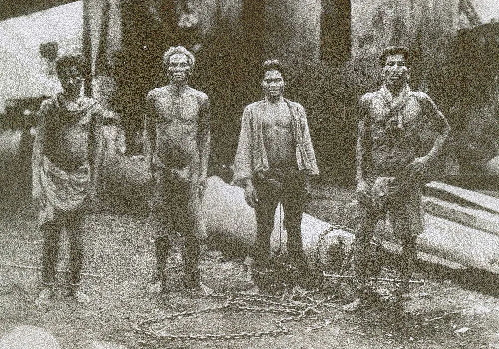
Ko Tarutao was selected because its isolated location and difficult natural terrain made escape extremely difficult. A government expedition reached the island in July 1937, and construction and pioneering work continued for almost a year. By 1938, Tarutao had become a correctional facility and vocational settlement.
Political prisoners were later sent to the island. In late 1939, 70 political prisoners associated with the Boworadet Rebellion and the Non-Commissioned Officers’ Rebellion were sent to Ko Tarutao and detained at Ao Talo Udang.
Today, the historic sites are part of the cultural landscape of the national park.
The forest is beautiful — but it also conceals traces of a period when the island was a place of forced isolation.
Ao Talo Udang
A living historical landscape
Ao Talo Udang is particularly important in understanding Tarutao’s prison history. The area was used for the former correctional settlement and political prisoner detention.
Today, visitors can explore the historical landscape and learn about the island’s former role through park interpretation and historical routes.
Rather than treating Tarutao simply as an island paradise, ThailandLover recommends experiencing this area as a living historical landscape.
Crocodile Cave — Tham Chorakhe
ถ้ำจระเข้ · mangrove approach, limestone interior
One of Ko Tarutao’s more unusual natural attractions is Crocodile Cave (Tham Chorakhe). The cave is reached by boat through a mangrove environment before continuing into the cave system. The interior contains limestone formations, including stalactites and stalagmites.
Government-linked tourism information describes the cave as approximately 300 metres deep, with the excursion involving a boat journey and exploration on foot. Visitors should arrange the trip through park staff rather than attempting to enter independently.
The Outer Islands
Ko Adang
เกาะอาดัง · second-largest island
Ko Adang is characterised by mountainous terrain, dense forest and beaches. One of its most famous attractions is Pha Chado Viewpoint, which looks toward Ko Lipe. Ko Adang is also associated with accommodation and camping managed within the national park system.
Because the island lies in the Adang–Rawi group, access is strongly dependent on seasonal marine conditions and annual park closure announcements.
Ko Lipe
เกาะหลีเป๊ะ · the tourism centre — not the wilderness
Ko Lipe is geographically part of the Tarutao National Park area, but its visitor experience is very different from Ko Tarutao and Ko Adang. It has developed into a major tourism centre with accommodation, restaurants, transportation services and other visitor infrastructure.
Tarutao National Park is the protected landscape. Ko Lipe is the highly developed tourism centre within that broader island system.
Travellers looking for a wilderness-oriented experience should not assume that staying on Ko Lipe provides the same atmosphere as staying on Ko Tarutao.
Ko Rawi
เกาะราวี
Compared with Ko Lipe, Ko Rawi is much less developed and is primarily experienced through marine excursions and nature-based tourism. Its beaches, forested interior and surrounding waters contribute to the classic island-hopping routes through the park.
Ko Rok Loi
เกาะรอกหลอย · compact white-sand stop
Ko Rok Loi is a small island known for its white beach and clear greenish-blue water. It is generally experienced as a stop during boat excursions rather than as a destination for long stays. Its triangular sandy shoreline and forested backdrop create one of the more recognisable visual landscapes of the outer island group.
Ko Hin Ngam
เกาะหินงาม · the black-stone beach
Ko Hin Ngam is one of the most distinctive small islands in the park. Its beach is covered not with conventional sand but with smooth dark pebbles and stones. When wet, the stones become glossy and reveal subtle patterns and tones.
The landscape is closely connected with local folklore and conservation messaging, and visitors should never remove stones from the beach. Ko Hin Ngam is also associated with nearby marine habitats and snorkelling sites.
Jabang Channel
ร่องน้ำจะบัง · soft coral and snorkelling
Jabang Channel (Rong Nam Jabang) is one of the better-known marine sites within the Adang–Rawi area. The site is associated with coral and soft-coral environments and is commonly included in snorkelling and marine excursions.
Visibility and sea conditions vary considerably with weather and season, so photographs seen during calm, clear conditions should not be treated as a guarantee of what visitors will see on any particular day.
Ko Khai — The Iconic Arch
เกาะไข่ · natural stone arch
Ko Khai is a small island famous for its natural stone arch. It is often included in boat routes through the Tarutao area and is one of the most recognisable photographic locations associated with the park — a good example of how relatively small islands can hold dramatic coastal formations created by long-term erosion.
Marine Life & Coral Reefs
Tarutao is important not only because of its beaches but because of the marine ecosystems surrounding the islands. Regional biodiversity information records extensive coral-reef areas within the park and identifies them as important habitats and nursery areas for marine life.
Visitors may encounter:
- Reef fish
- Hard corals
- Soft corals
- Sea anemones
- Crustaceans
- Molluscs
- Sea birds
- Marine reptiles
Historical tourism sources also record sea turtles in the wider park environment. However, travellers should not treat turtle sightings as guaranteed.
The same principle applies to coral: a beautiful reef exists because it is alive, not because it is a decorative attraction. Do not touch coral, stand on reefs, collect marine organisms or feed wildlife.
Forests & Wildlife
Tarutao’s ecological value extends well beyond the sea. The park contains several habitat types, including moist evergreen forest, dry evergreen forest, mixed deciduous forest, mangrove forest, beach forest, secondary forest, scrub and coastal environments.
Regional biodiversity sources have recorded a substantial diversity of mammals and birds across the park. Wildlife records include dusky langurs, crab-eating macaques, wild pigs, mouse deer, squirrels, tree shrews and numerous bird species including hornbills and raptors.
Hiking in Tarutao
Ko Tarutao offers a more substantial hiking experience than many visitors expect.
- ~12 km
- Park headquarters around Ao Phante Malacca → Ao Talo Wao through forest.
- ~8 km
- Route linking areas around Ao Chak, Ao Mo Lae and Ao Son, according to Thai tourism information.
These are not beach walks. Conditions can include heat and humidity, slippery surfaces, uneven terrain, dense vegetation and limited mobile connectivity.
Hikers should carry sufficient water, wear suitable footwear and follow current instructions from park officers.
The Geological Story of Tarutao
The wider Satun UNESCO Global Geopark, designated in 2018, covers areas of exceptional geological importance in Satun Province. UNESCO highlights the region’s Paleozoic fossil heritage and notes that Cambrian trilobites discovered on Ko Tarutao are among the oldest recorded in the Thai–Malay Peninsula.
Its importance is not simply scenic — the islands also preserve evidence of ancient geological environments over hundreds of millions of years.
Best Time to Visit
The broad travel season for the Tarutao island groups is generally November to May. Marine conditions are normally more favourable during the northeast-monsoon season, while the southwest monsoon can bring stronger winds, waves and heavy rainfall.
However, the exact operating status of individual islands and marine sites changes by annual DNP announcement.
Never rely on a generic “November–May” statement alone. Check the current DNP announcement immediately before travelling.
How to Get There
From Bangkok via Pak Bara
The most practical route is generally:
Bangkok → Hat Yai → Satun / Pak Bara → Boat → Tarutao National Park
Pak Bara Pier is the principal mainland gateway for marine travel into the park. Thailand Tourism Authority information places Ko Tarutao approximately 22 kilometres offshore from Pak Bara Pier. From the pier, boat services connect the mainland with the islands, although schedules and routes are seasonal.
How Many Days Should You Spend?
- 1 Day — Quick Island Experience
- Boat journey, Ko Tarutao, Ao Phante Malacca, Pha To Bu, selected historical sites, return to mainland.
- 2 Days / 1 Night — The Better Introduction
- Ko Tarutao, sunset at Pha To Bu, historical areas, forest walks, Ao Son, Crocodile Cave (subject to availability), overnight in the park.
- 3–4 Days — Nature & Island Exploration
- Combine Ko Tarutao + Ko Adang/Rawi + Ko Hin Ngam + Ko Rok Loi + marine excursions when seasonal access allows. Best for travellers interested in both the terrestrial and marine sides of the park.
Where to Stay
For the more nature-oriented experience, consider staying within the national park on Ko Tarutao. The DNP provides accommodation and camping facilities through its current reservation system.
Accommodation is intentionally simple. This is not a resort-island experience — it is designed around proximity to nature.
For travellers who prefer restaurants, nightlife and a much wider range of accommodation, Ko Lipe offers a completely different tourism environment.
What to Bring
- Lightweight quick-dry clothing
- Good walking shoes
- Sandals for beach areas
- Sun protection
- Insect repellent
- Reusable water bottle
- Waterproof bag
- Power bank
- Personal medication
- Small first-aid kit
- Flashlight / headlamp
- Dry bag for boat trips
- Snorkelling equipment if appropriate
For overnight stays on the quieter islands, prepare for much simpler facilities than those found on Ko Lipe.
Responsible Travel in Tarutao
Tarutao is a protected marine ecosystem. The most important visitor rules are simple:
- Do not take anything from the park
- Especially coral, shells, stones, marine organisms and plants. Ko Hin Ngam is an especially clear example of why this matters.
- Do not touch coral
- Even brief physical contact can damage living coral.
- Do not feed wildlife
- Feeding monkeys and other wildlife changes their natural behaviour and can create conflict with people.
- Carry your waste out
- If there is no appropriate disposal facility, take your waste with you.
- Follow seasonal closures
- A closed island is not a suggestion. Seasonal closures are part of conservation and visitor-safety management.
Photography Guide
Tarutao works particularly well for photographers because its visual identity changes dramatically between locations.
- Ko Tarutao
- Rainforest, historic buildings, long beaches, mangroves, Pha To Bu, sunrise at eastern bays.
- Adang–Rawi
- White beaches, turquoise water, limestone and granite islands, coral reefs, island silhouettes.
- Ko Hin Ngam
- Wet black stones — minimalist coastal photography.
- Pha To Bu
- Sunset, layered islands, wide-angle seascapes.
For the ThailandLover visual language, avoid presenting Tarutao only as an exaggerated tropical paradise. Its strongest story is the contrast between wild landscape + deep forest + open sea + human history.
Tarutao vs Ko Lipe
These destinations are often treated as if they are the same experience. They are not.
- Tarutao National Park
- Protected natural landscape · strong forest · historical prison sites · quiet and nature-oriented · national park accommodation · hiking and ecological exploration · best for nature/history
- Ko Lipe
- Developed island tourism centre · strong tourism infrastructure · restaurants, hotels and shops · more active and commercial · wide range of private accommodation · beach, dining and island activities · best for convenience
A ThailandLover itinerary can combine both. Ko Lipe gives you the convenience. Ko Tarutao gives you the story.
ThailandLover Recommended Experience
If you have enough time, do not treat Tarutao as simply another island-hopping stop.
- Day 1 — Pak Bara → Ko Tarutao
- Settle into the national park. Explore Ao Phante Malacca. Walk to Pha To Bu for sunset.
- Day 2 — History + Forest
- Explore historic areas around Ao Talo Udang and Ao Talo Wao. Consider a forest trail or Crocodile Cave excursion, depending on current conditions and park arrangements.
- Day 3 — Outer Islands
- Travel toward the Adang–Rawi group. Explore suitable marine sites such as Ko Hin Ngam, Ko Rok Loi or other islands open under current seasonal regulations.
- Day 4 — Adang / Lipe
- Continue toward Ko Adang or Ko Lipe, depending on your itinerary.
This approach allows Tarutao to unfold as a complete destination rather than as a single photograph.
Essential Information
- Official Name
- Tarutao National Park
- Thai
- อุทยานแห่งชาติตะรุเตา
- Province
- Satun
- Established
- 19 April 1974
- Area
- Approximately 1,490 sq km
- Islands
- 51
- Major Groups
- Tarutao and Adang–Rawi
- Largest Island
- Ko Tarutao
- Main Mainland Gateway
- Pak Bara Pier
- Best General Season
- November–May
- International Recognition
- ASEAN Heritage Park, 1982
- Geopark
- Within the wider Satun UNESCO Global Geopark region
ThailandLover Quick Take
- Go for
- Rainforest · Islands · Coral reefs · Hiking · History · Photography · Nature
- Best for
- Independent travellers · Nature lovers · Photographers · Families seeking nature · History enthusiasts · Responsible island travellers
- Don’t expect
- A single resort-style island experience
- The signature experience
- Ko Tarutao + Pha To Bu + historical sites + the Adang–Rawi marine landscape
Not a ranking — Tarutao is valuable precisely because it offers a different kind of island experience: less about luxury, more about landscape, history and protected nature.
Frequently Asked Questions
- What is Tarutao National Park?
- Thailand’s first marine national park (19 April 1974) in Satun — about 1,490 km² and 51 islands across the Tarutao and Adang–Rawi groups: rainforest, reefs, beaches and historic prison sites.
- Is Tarutao a UNESCO World Heritage Site?
- No. It is an ASEAN Heritage Park (1982) and part of the wider Satun UNESCO Global Geopark region, but it was not inscribed as a World Heritage Site.
- How do I get there?
- Bangkok → Hat Yai → Satun / Pak Bara Pier → boat. Ko Tarutao is about 22 km offshore from Pak Bara.
- When is the best time to visit?
- Generally November–May — always verify current DNP seasonal closures before you go.
- What is the difference between Tarutao and Ko Lipe?
- Tarutao is the protected forest-and-history landscape. Ko Lipe is the developed tourism centre within the same wider island system.
- Can I stay overnight on Ko Tarutao?
- Yes — DNP accommodation and camping. Facilities are simple and nature-oriented. Check the reservation system before travelling.
- How long should I spend?
- One day for a quick visit; two days with one overnight for a better introduction; three to four days to combine Tarutao with open Adang–Rawi sites.
More Andaman & Satun Parks
- Mu Ko Phetra National Park
- Satun and Trang limestone islands — Ao Nun, Ko Lidi, Ko Bulon and coastal geology.
- Thale Ban National Park
- Satun inland forest and wetland — a different face of the province.
- Hat Chao Mai National Park
- Trang’s limestone coast, Emerald Cave and dugong seascapes.
- Mu Ko Similan National Park
- Phang Nga’s famous Andaman reefs and island day trips.
- Mu Ko Surin National Park
- Northern Andaman marine wilderness and coral gardens.
Location
Find Tarutao National Park
Satun · Andaman Sea · Access via Pak Bara Pier