


Marine National Park · Phang Nga
Mu Ko Similan National Park
อุทยานแห่งชาติหมู่เกาะสิมิลัน
The Granite Islands of the Andaman Sea
Phang Nga · Southern Thailand · Andaman Sea
Few places in Thailand have a name that almost becomes a synonym for Thai seas. Similan is one of them — not only turquoise water and white sand, but granite, reef, turtles and a protected island ecosystem that tourism must share carefully.
More Than a Postcard
If we see Similan only as blue water, white sand and photo stops, we miss the story that matters most.
Behind the beauty is a world of granite rock, island forest, beaches shaped by weathering and marine sediment, coral reefs, underwater boulder fields, sea turtles and an ecosystem that needs tightly managed tourism.
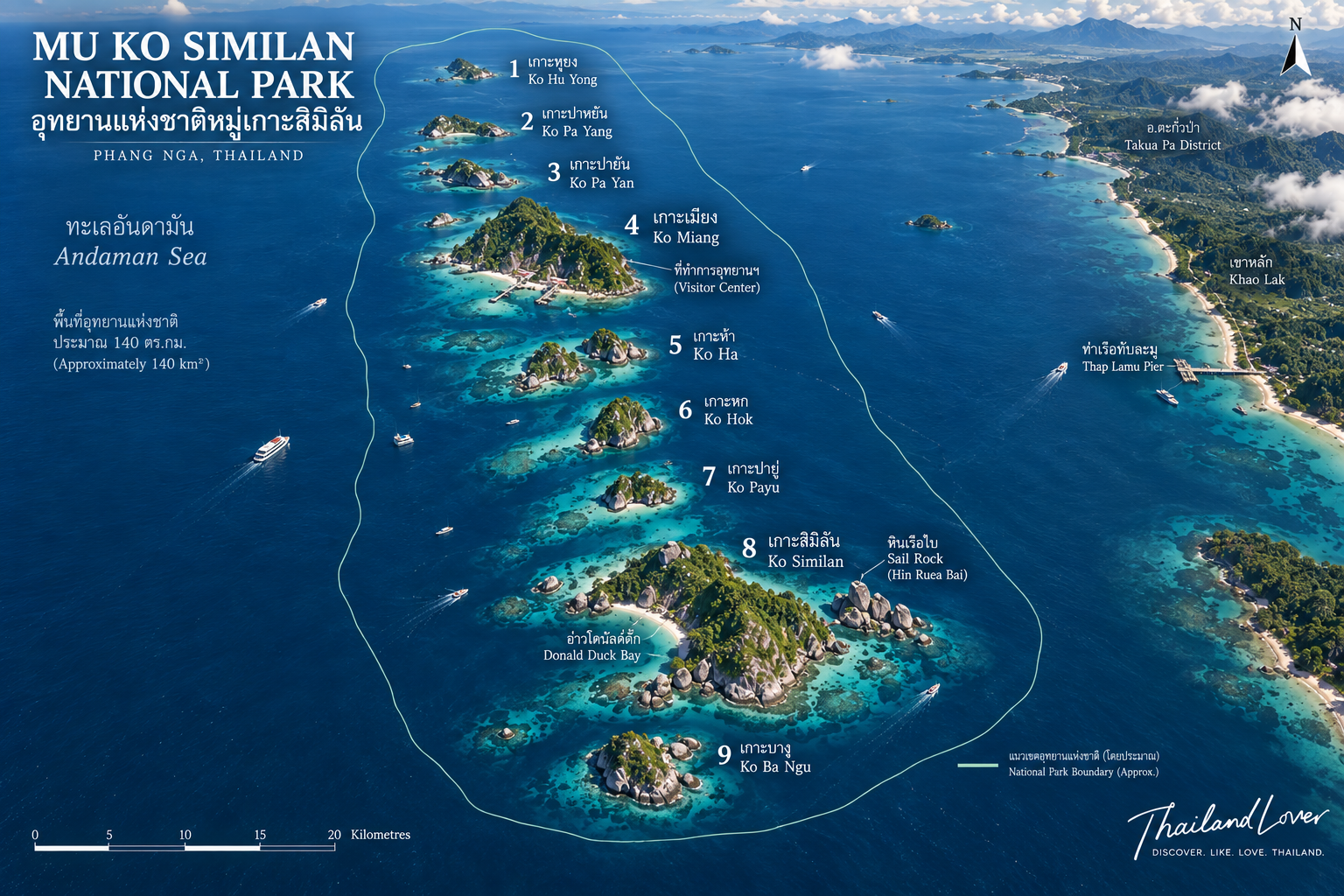
The islands lie about 70 kilometres off the Phang Nga coast and form a north–south chain of 11 islands in the Andaman Sea.
Similan is not merely a destination. It is a protected island ecosystem — where nature and travel must coexist carefully.
Beauty is only the beginning.
The Park at a Glance
- Official Name
- Mu Ko Similan National Park
- Thai Name
- อุทยานแห่งชาติหมู่เกาะสิมิลัน
- Province
- Phang Nga
- District
- Khura Buri
- Subdistrict
- Ko Phra Thong
- Region
- Southern Andaman coast
- Sea
- Andaman Sea
- Area
- Approx. 140 km² / 87,500 rai
- Established
- 1 September 1982
- National Park No.
- 43rd of Thailand
- Original Area
- Approx. 128 km²
- Expansion
- Ko Bon & Ko Tachai added in 1998
- Islands
- 11 (originally 9)
- Main Geology
- Granite
- Opening Season
- 15 October – 15 May
- Travel Format
- One-day trip / diving
- Overnight on Islands
- Not permitted for tourists
- Signature Island
- Ko Similan / Island No. 8
- Signature Landmark
- Sail Rock
- Signature Bay
- Horseshoe Bay
- Main Visitor Island
- Ko Miang / Island No. 4
- Major Activities
- Snorkeling & scuba diving
- Mainland Gateway
- Thap Lamu / Khao Lak area
Park establishment records note an original area of about 128 km². After Ko Bon and Ko Tachai were added in 1998, the total became roughly 140 km².
Where Is Mu Ko Similan?
The Similan Islands sit in the Andaman Sea, west of Phang Nga Province. The park’s terrestrial area falls within Ko Phra Thong Subdistrict, Khura Buri District.
About 70 kilometres from the mainland, Similan feels more like an offshore island wilderness than a nearshore beach island. Access is by boat, and sea conditions shape every journey.
What Does “Similan” Mean?
The word Similan comes from Yawi or Malay and means “nine” — because the original group was nine main islands.
Hence Mu Ko Similan — the Nine Islands. Even though the park now protects 11 islands, the name still carries the history of that original nine.
From Nine Islands to Eleven
When the park was declared in 1982, it covered the original nine islands. In 1998, Ko Bon and Ko Tachai were added — bringing the total to 11.
The Eleven Islands · North to South
- Ko Tachai
- Ko Bon
- Ko Ba Ngu — Island No. 9
- Ko Similan — Island No. 8
- Ko Pa Yu — Island No. 7
- Ko Hok — Island No. 6
- Ko Ha — Island No. 5
- Ko Miang — Island No. 4
- Ko Pa Yan — Island No. 3
- Ko Payang — Island No. 2
- Ko Hu Yong — Island No. 1
Ko Miang ≠ Ko Similan. Ko Bon ≠ Ko Tachai. Each island has its own landscape, habitat and role.
The Granite Islands
If one word should stick when you talk about Similan, it is granite.
Most of the islands are granite terrain — a different geology from the limestone karst common in Phang Nga and Krabi. Instead of layered cliffs and caves, Similan is full of massive granite boulders, stacks, cliffs and strange rock shapes carved by waves and weathering.
Coasts are irregular. Western shores are often steeper and more exposed; eastern sides hold more beaches and reefs in places — a wild coast and a sheltered coast on the same island.
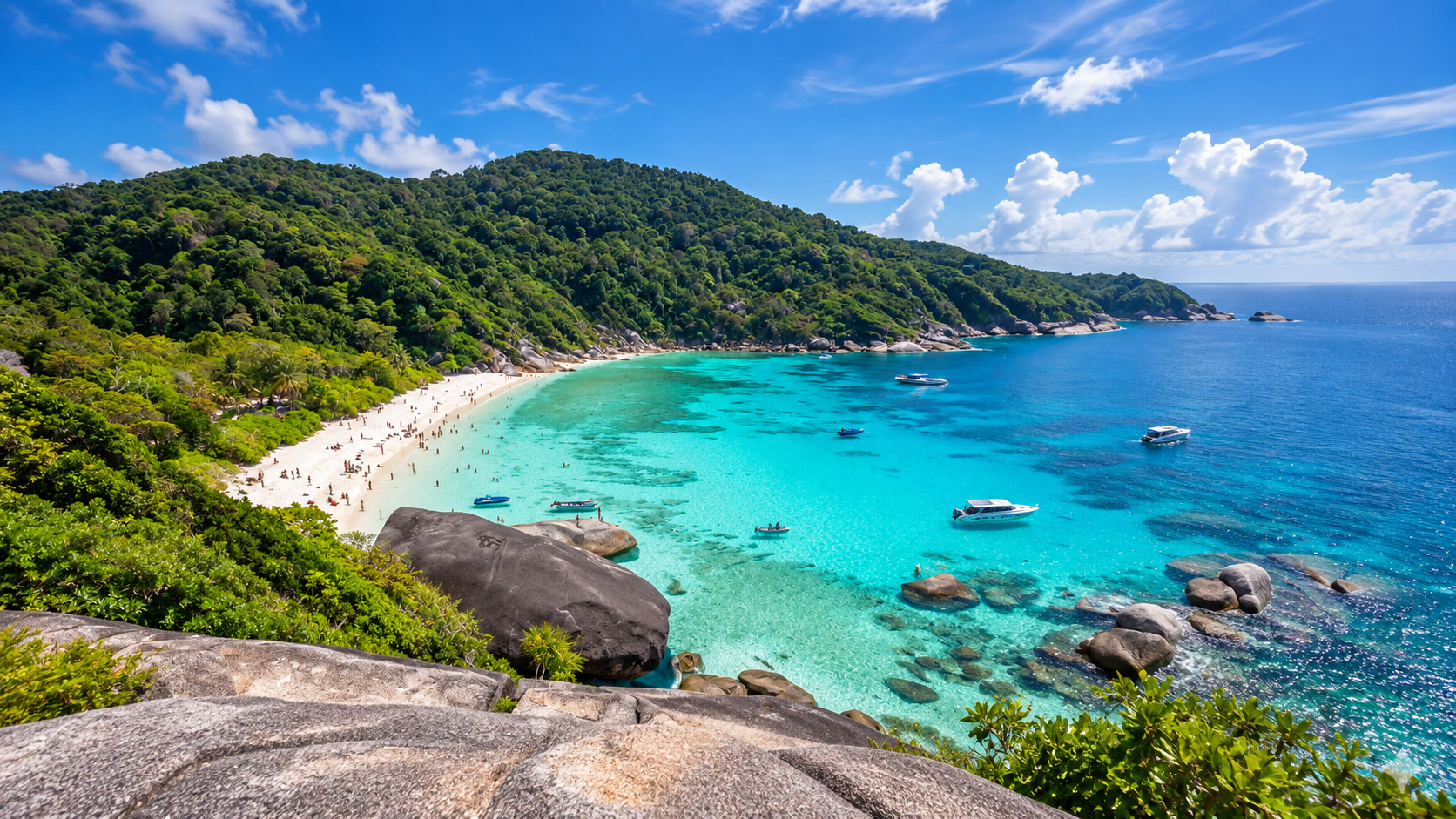
That is why so many Similan photographs hold the same frame: granite boulders + white sand + turquoise water.
Ko Similan — Island No. 8
เกาะแปด · The Face of Similan
If one island is the “face” of the park, it is Ko Similan — the largest island and the one visitors know best. Here you find beaches, bays, forest, granite, walking trails, viewpoints and the park’s most famous landmarks.
Sail Rock
หินเรือใบ · The Visual Identity of Similan
Sail Rock is the park’s most famous symbol — a great granite mass that, from some angles, looks like a sail above the sea. Images of this rock have become almost the visual identity of the islands.
For ThailandLover, the deeper point is that it was never built as a landmark. It is the result of geology + weathering + erosion + time. Nature made its own monument.
From around Sail Rock, a nature trail climbs to a viewpoint — Tourism Authority of Thailand information cites about 150 metres. From the top, the bay opens in roughly a 180-degree sweep. Rock, forest, beach and sea read as one landscape.
Horseshoe Bay
อ่าวเกือก · Signature Beach Landscape
Horseshoe Bay is a defining bay of Ko Similan — a curved shoreline wrapped by granite and forest, fine sand and clear water when conditions are right. In 2026, the Department of National Parks reported that Horseshoe Bay was ranked among the world’s Top 10 beaches — a reflection of its international landscape reputation.
Ko Miang — Island No. 4
เกาะเมียง · Visitor Island & Twin Beaches
Ko Miang was historically a visitor-service hub. It has beaches on two sides: Princess Beach (หาดเจ้าหญิง) and Honeymoon Beach (หาดเล็ก), linked by an island trail — a clear contrast of east-coast and west-facing shorelines.
Princess Beach is one of the best-known sands on Ko Miang — fine sand, clear water, forest behind. Treat it as part of an ecosystem, not only a photo set. Honeymoon Beach is smaller and quieter.
One animal that has become a local character here is the chicken crab (ปูไก่). Watch and photograph responsibly — do not catch or disturb wildlife for a shot.
Ko Hu Yong — Island No. 1
เกาะหูยง · Sea Turtle Sanctuary
The southernmost of the original islands, Ko Hu Yong has a long beach and critical value for sea-turtle conservation. It is not open for ordinary tourist landings.
Not every beautiful island is a tourist island. Some places matter more as habitat than as attractions.
Beaches on Hu Yong and other southern islands can serve as nesting ground. In 2026 (B.E. 2569), the park reported ongoing green-turtle hatchings — a reminder that closing access is wildlife management, not inconvenience for its own sake.
Ko Payang & Ko Pa Yan
Ko Payang (Island No. 2) is mountainous rock and cliff, with small sand pockets and restricted access. Resource information notes naval oversight and that outsiders are not permitted to land; coral surrounds the island.
Ko Pa Yan (Island No. 3) is very small, steep and cliffy, without large beaches — not a land-tourism island, but valuable for marine habitat and reef around its shores.
Ko Ha, Ko Hok & Ko Pa Yu
- Ko Ha · Island No. 5
- A small island with varied underwater terrain. One site often mentioned is the Garden Eel area, with soft coral, sea fans and fish schools.
- Ko Hok · Island No. 6
- Popular with divers for reef and underwater variety. TAT notes nearly 200 metres of reef in places. A reminder that Similan is often more impressive below the surface than above it.
- Ko Pa Yu · Island No. 7
- Favoured for snorkeling and diving — reefs and rock piles. Wave, current and visibility change constantly; never treat brochure conditions as a daily guarantee.
Ko Ba Ngu — Island No. 9
เกาะบางู · Advanced Diving Landscape
Mostly rocky coasts and cliffs rather than big beaches — but famous underwater. Signature sites include Christmas Point and Three Trees: boulder fields, channels, caves and swim-throughs that give diving a different character from shallow reef gardens.
Ko Bon — The Manta Island
North of the original group, Ko Bon draws divers to areas such as West Ridge. Currents and underwater topography can concentrate large pelagic life at times — including manta rays.
Manta Ray is a possibility, not a promise.
Ko Tachai
The Island That Nature Asked Us to Wait For
One of the most beautiful islands in the group — white sand, clear water, a strongly natural character. Tourists cannot currently land on Ko Tachai.
TAT information for 2026 states the island remains closed for nature recovery, closed to tourist landings since 2016.
Conservation sometimes means saying no to tourism.
The Underwater World
Similan’s global reputation comes from the world below — not only clear water, but reefs, soft corals, sea fans, boulder fields, caves, channels, walls, sandy bottoms, coral gardens and pelagic species.
What sets many sites apart is that underwater terrain still echoes the granite above: boulders, walls, ledges, swim-throughs and pinnacles. Divers are exploring an underwater granite landscape, not only looking at coral.
Notable Dive Sites
- Christmas Point — boulder fields and swim-throughs
- Elephant Head Rock — complex granite channels, caves and soft coral; currents can be strong
- West of Eden / East of Eden — reef and rock landscapes
- Shark Fin Reef — underwater rock piles resembling shark fins from above
- Honeymoon Bay — reef around Ko Miang
Which sites are open can change with park management and sea conditions.
Marine Life
Reef fish, groupers, barracuda, butterflyfish, parrotfish, lionfish, clownfish, angelfish, eels, crabs, shrimp, starfish, sea urchins, sea fans and soft corals are part of the reef community. Larger animals known to occur include manta rays, turtles and dolphins; whales or rarer species may appear in the wider area.
- Omura’s Whale · 2026
- In May 2026, DNP reported a group of Omura’s whales near Similan — estimated at no fewer than five animals. A reminder that these waters belong to a larger Andaman marine ecosystem.
- Dolphins · 2026
- In March 2026, DNP reported more than 50 bottlenose dolphins near Fantasy Rock. Use this as a recent wildlife record — not as “dolphins every day.”
- Sea Turtles
- Nesting habitat on selected beaches; green-turtle hatchings tracked in 2026. Beaches are nesting ground, not only recreation.
ThailandLover prefers “may encounter” or “known to occur” — never “guaranteed to see.”
Why the Park Closes
Current published season: open 15 October – 15 May; closed after 16 May so land and sea systems can recover.
Closure is not only “rain and waves.” It also supports coral recovery, lower visitor pressure, waste and wastewater management, patrols, marine wildlife care, and safety for visitors and staff.
In 2026 the park continued coral surveys even outside the tourism season, tracking change and restoration — with climate change noted as a factor that must be watched seriously.
No Overnight Tourism
Tourists cannot currently stay overnight on the Similan islands. DNP cancelled tourist overnight stays from 4 October 2018, shifting to day-trip formats to address waste, wastewater and ecological impact.
Older guides that still advertise camping on Island 4 or Island 8 should not be used for current ThailandLover planning. This is date-aware travel information.
Primary format today: one-day island experience and diving (day diving or liveaboard within seasonal rules).
Things to Do
- One-Day Island Trip
- Morning departure, beaches and snorkeling, lunch, return afternoon or evening — timing depends on pier, boat type, sea state and operator itinerary.
- Snorkeling
- Designated sites when conditions are calm. Rule one: Look. Don’t touch.
- Scuba Diving
- Day diving or liveaboard. Match site and current to certification and experience; follow dive guides and use mooring buoys.
- Landscape & Viewpoint
- Sail Rock trail, Horseshoe Bay, granite boulder photography — stay on designated routes.
Travel Smart · Match the Island to You
- Beach person — Ko Miang + Ko Similan
- Photographer — Sail Rock + Horseshoe Bay
- Snorkeler — Ko Pa Yu and designated snorkel areas
- Diver — Ko Hok, Ko Ba Ngu, Ko Bon and itinerary sites
- Wildlife lover — turtle conservation story + marine wildlife (no guarantees)
- Slow traveller — fewer stops, more time reading the landscape
How to Get There
- From Bangkok
- Fly or travel to Phang Nga or Phuket, then continue to Thap Lamu Pier (Thai Mueang, Phang Nga) — a main gateway for Similan boats.
- From Phuket
- A major international gateway. Road transfer to Phang Nga-side piers, then boat to the islands.
- From Khao Lak
- Closest popular base for Thap Lamu day trips — a favourite launching point for Similan visits.
Boat time depends on boat type + departure point + sea conditions. Fast boats may take roughly 1–1.5 hours in good conditions — treat that as orientation, not a guarantee.
Best Time to Visit
Under the current system, 15 October – 15 May is the window for tourism: snorkeling, diving, island sightseeing, beach time and photography.
That does not mean every day is calm and clear. Early season can still carry previous weather; mid-season is often better for marine activities; late season needs closer attention to wind and rain. “Best month” is not one answer for divers, photographers, families and calm-sea seekers.
What to Bring — and What Not To
- Water, hat, sunglasses, sun shirt, dry clothes, walking shoes
- Dry bag, towel, personal medication, camera
- Mask, snorkel and fins if your operator does not provide them
- Reusable bottle and bag; reef-safe sunscreen; zero-waste mindset
Do not bring excess single-use plastic, foam containers, or gear that can damage coral. Do not collect shells, corals, rocks or any living thing from the park.
Responsible Travel
On the beach: stay in designated areas; do not take sand or shells; do not disturb animals; take all rubbish with you.
In the water: do not stand on or touch coral; do not chase or feed fish; control buoyancy; use designated moorings. In 2026, Similan staff still recovered ghost nets and fishing debris to protect reef and wildlife.
Around wildlife: keep distance; no flash near animals; no chasing for photos; no nesting-area entry.
Who Should Visit?
- Best for
- Nature lovers, divers, snorkelers, photographers, families, first-time Thailand visitors, marine wildlife enthusiasts, responsible travellers.
- Less suitable for
- Travelers seeking nightlife, luxury resort stays on the islands, long island stays, unlimited beach access, or large-scale entertainment.
Before You Go
- Opening season — 15 October – 15 May
- Weather — forecast and sea state
- Boat schedule — departure and return
- Park rules — latest DNP regulations
- Closed areas — which islands or sites are open that season
- Diving conditions — sites and your certification level
- Travel insurance — especially for water sports and diving
Current baseline policy: open season 15 Oct–15 May; closed season principally 16 May–14 Oct; no tourist overnight on the islands; primary formats are one-day trip and diving — confirmed in DNP guidance for 2026.
ThailandLover Field Notes
- Destination
- Mu Ko Similan National Park
- Province
- Phang Nga
- Landscape
- Granite islands · white beaches · tropical forest · coral reefs · open Andaman Sea
- Signature Landmark
- Sail Rock
- Signature Island
- Ko Similan / Island No. 8
- Signature Beach
- Horseshoe Bay
- Signature Visitor Island
- Ko Miang / Island No. 4
- Signature Wildlife
- Sea turtles · manta rays · dolphins · reef life
- Signature Experience
- Snorkeling + diving + granite island landscape
- Travel Style
- Nature · marine · adventure · responsible travel
The Islands Have Different Jobs
- Ko Similan
- Landscape + viewpoint + beach
- Ko Miang
- Visitor service + beach + forest
- Ko Hu Yong
- Sea-turtle conservation
- Ko Payang / Ko Pa Yan
- Marine habitat
- Ko Ha / Ko Hok / Ko Pa Yu
- Diving & snorkeling
- Ko Ba Ngu
- Advanced diving landscape
- Ko Bon
- Pelagic marine life
- Ko Tachai
- Conservation & recovery
Frequently Asked Questions
- Why is it called Similan?
- Because “Similan” comes from Yawi/Malay and means “nine”, referring to the original nine islands.
- How many islands are there?
- Currently 11. The original group had nine; Ko Bon and Ko Tachai were added in 1998.
- Which island is the biggest?
- Ko Similan — Island No. 8, also the park’s strongest visual identity.
- What is Similan famous for?
- Granite landscapes, white beaches, clear water, coral reefs, snorkeling, scuba diving and marine biodiversity.
- Can I climb Sail Rock?
- Follow the designated trail to the viewpoint. Do not leave the route or climb unstable formations.
- Can I stay overnight?
- No for ordinary tourists. Overnight accommodation was cancelled in 2018; the park runs mainly as day-trip and diving.
- Can I visit Ko Tachai?
- Not for ordinary island visits. TAT’s 2026 information states it remains closed to tourist landings for nature recovery.
- Can I visit Ko Hu Yong?
- It is an important sea-turtle nesting area and is not open for ordinary tourist visits.
- Can I see manta rays?
- They occur in the wider Similan–Bon area, but sightings vary. Never treat them as guaranteed.
- Can I see whale sharks?
- They may occur in the wider Andaman diving region; a sighting at a specific Similan site is never guaranteed.
- Is Similan good for beginners?
- Snorkeling at designated calm sites can suit beginners. Scuba depends on site, current and certification.
- Is Similan open all year?
- No. Tourism season is generally 15 October–15 May, then seasonal closure.
Related Destinations
- Mu Ko Surin National Park
- Similan’s northern Andaman sister — another offshore marine park from the Khura Buri coast.
- Mu Ko Ra–Ko Phra Thong
- Closer coastal islands sharing the same Phang Nga waterscape and gateway region.
- Khao Lak–Lam Ru National Park
- Mainland rainforest and coastline behind the popular Similan day-trip base.
- Si Phang-nga National Park
- Inland waterfalls and forest in Phang Nga — a different face of the same province.
- Hat Chao Mai National Park
- Andaman marine park further south — dugongs, seagrass and Trang’s coastal islands.
- Tarutao National Park
- The Andaman’s great southern island park — another lesson in space, season and conservation.
- Mu Ko Lanta National Park
- Krabi’s island park — beaches, reefs and a different Andaman rhythm.
- Mu Ko Phetra National Park
- Satun–Trang limestone and island seascapes along the lower Andaman.
Location
Find Mu Ko Similan National Park
Andaman Sea · Ko Phra Thong, Khura Buri, Phang Nga · Gateway: Thap Lamu / Khao Lak