



National Park · Satun
Thale Ban National Park
อุทยานแห่งชาติทะเลบัน
A Hidden Wetland in the Rainforest Along Thailand’s Malaysian Border
Khuan Don · Mueang Satun · Southern Thailand
A freshwater lake inside a mountain valley, then rainforest, caves, waterfalls and a forest that keeps going toward Malaysia. This is Satun beyond the islands.
Not a Sea Park
Thale Ban National Park (อุทยานแห่งชาติทะเลบัน) is one of southern Thailand’s most unusual inland national parks. Despite the name, it is not a marine national park. It is a protected land-based forest and wetland in southern Satun, stretching along the Thai–Malaysian border.
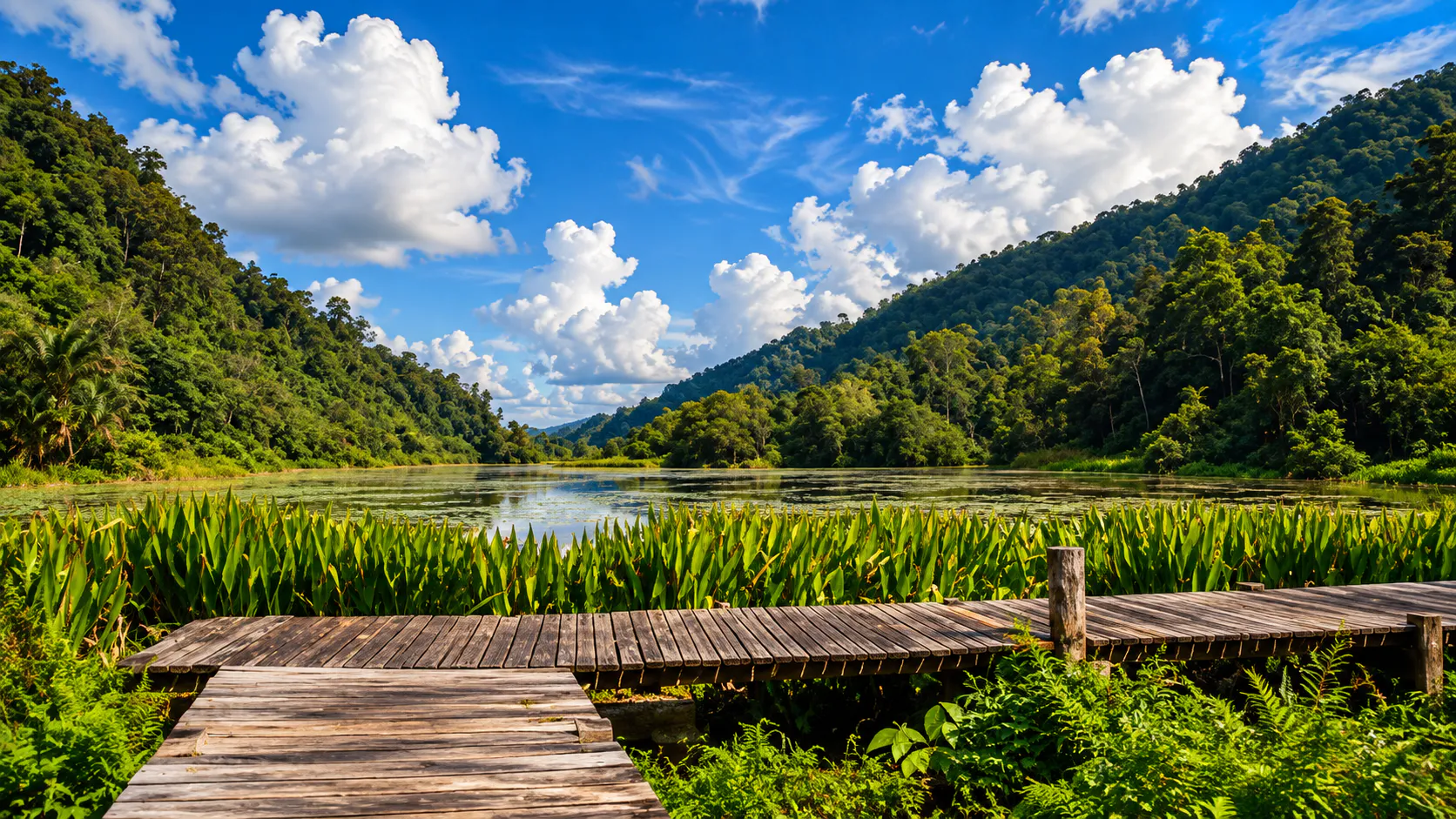
Inside one relatively compact area you find a freshwater lake, rainforest, limestone mountains, granite landscapes, caves, waterfalls, wetlands and wildlife habitat. At the centre lies Bueng Thale Ban, a freshwater wetland ringed by mountains. The lake is the visual heart of the park.
Beyond the water, Thale Ban becomes wilder. Streams drop from the mountains, caves cut through limestone, waterfalls appear in the forest, and the western edge reaches the Andaman coastal environment. For travellers exploring Satun past the better-known islands, this is a different side of the province.
The destination is the ecosystem itself.
At a Glance
- ~196 km²
- Current area — about 122,500 rai, after the 1991 expansion.
- 1980
- Established 27 October as Thailand’s 20th national park.
- 125 rai
- Bueng Thale Ban, the freshwater wetland at the centre.
- 756 m
- Highest point, in the Chin mountain range.
- Perlis
- The southern boundary meets Malaysia.
- Thai name
- อุทยานแห่งชาติทะเลบัน
- Province
- Satun, Southern Thailand
- Main districts
- Khuan Don and Mueang Satun
- Park type
- Terrestrial national park
- Landscape
- Rainforest, freshwater wetland, mountains, limestone, granite, caves and waterfalls
- Originally established
- 27 October 1980 — about 101.68 km²
- Expanded
- 1991, adding forest toward the Puyu coastal area
- Signature landscape
- Bueng Thale Ban
- Signature wildlife
- Khiat Wak — the “Water Dog” frog
- Main waterfalls
- Ya Roi and Ton Plio
- Major caves
- Ton Din, Pha Diao and Puyu
- Border
- Perlis, Malaysia
Thale Ban was officially established on 27 October 1980 as Thailand’s 20th national park. The protected area was later expanded in 1991 to include additional forest toward the Puyu coastal area, bringing the park to approximately 196 square kilometres.
Why Thale Ban Is Different
Several geographical systems meet inside the same protected landscape. You can move through them in one visit:
- Freshwater wetland
- Rainforest
- Mountain streams
- Limestone caves
- Waterfalls
- Granite mountains
- Border forest
- Andaman coastal ecosystems
The park works particularly well for travellers interested in nature rather than a single viewpoint. It is a clear example of a national park protecting an entire ecological system.
The Story Behind the Name
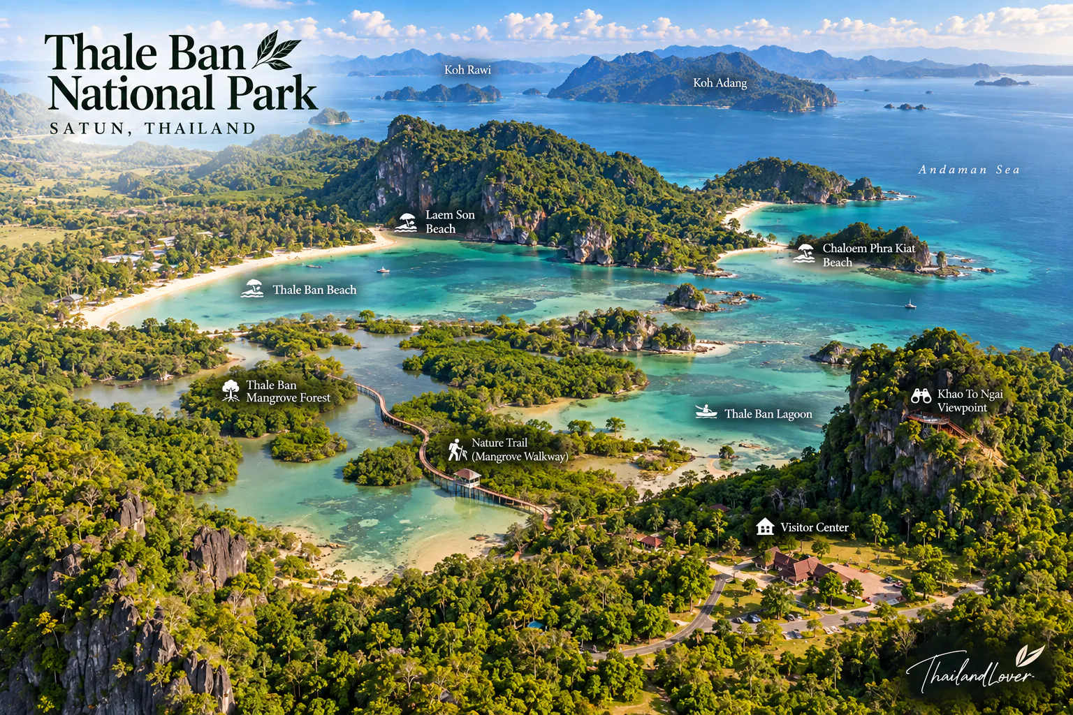
The name Thale Ban is associated with the local Malay term “Lert Re Ban”, referring to a collapsed or subsided body of water.
According to the Department of National Parks’ historical account, the large wetland formed between Khao Chin and Khao Mot Daeng, where the ground subsided and created a freshwater basin. The name later evolved into “Thale Ban.”
The lake is not a scenic pond placed in the forest. It is part of the geological structure of the landscape.
Bueng Thale Ban
บึงทะเลบัน · the green heart of the park
Bueng Thale Ban is the most recognisable landscape in the national park. The freshwater wetland covers approximately 125 rai and sits in a valley surrounded by the Chin and Wang Pra mountain ranges.
Dense vegetation borders the lake, including the distinctive Bakong aquatic plant, which grows abundantly around the wetland. A wooden walkway and waterside resting areas let visitors experience the water without having to enter the forest itself. This is the best place to begin.
The Wetland Walk
The wooden nature walkway around Bueng Thale Ban is one of the easiest ways into the park. It suits slow walks, birdwatching, nature photography, plant observation, family visits and early-morning exploration.
The atmosphere changes through the day. In the morning, mist and soft light can settle around the water and forest. Later, sunlight opens the vegetation and the mountain walls.
For photographers, the strongest images are often the smaller ones: water plants, reflections, tree textures, birds, and the line where open water meets dense forest.
The Bakong Wetland
One visual signature of Bueng Thale Ban is Bakong, a distinctive aquatic plant growing densely around parts of the lake. The vegetation creates a clear transition:
- Open freshwater
- Wetland plants
- Forest edge
- Mountain forest
That makes the lake an excellent place to understand wetland ecology without a difficult hike. It is also important habitat for freshwater organisms, birds and amphibians.
Meet the “Water Dog”
Khiat Wak · the sound of Thale Ban
One of Thale Ban’s most unusual natural features is not something you necessarily see. It is something you hear.
The Khiat Wak, also locally known as Ma Nam or “Water Dog,” is an amphibian of the wetland around Bueng Thale Ban. Its call has been described as resembling a young dog. The calls are particularly noticeable during quiet periods, especially at night and in wetter conditions. The animal has become one of the natural symbols of the park.
Sometimes the most memorable wildlife experience begins with a sound rather than a photograph.
Ya Roi Waterfall
น้ำตกยาโรย · nine levels in the forest
Ya Roi Waterfall is one of the principal attractions of the park. It originates in the headwaters of the Hua Kraming forest in the Chin mountain range and descends through nine levels. Several levels form natural pools.
The upper section is particularly scenic, where water divides into streams as it falls over the rock face. Local government information describes the upper waterfall as having a drop of approximately 10 metres. Humid forest surrounds the falls, so the journey feels more remote than the short distance from the main visitor area might suggest.
Visiting Ya Roi
Ya Roi is approximately 6.7 kilometres from the park headquarters, with a further short access section to the waterfall area according to local government information. The environment can become slippery in wet weather. Expect forest trails, uneven rocks, wet surfaces, stream crossings or streamside walking, and stronger flow during rainy periods.
Ton Plio Waterfall
น้ำตกโตนปลิว · water from the Chin mountains
Ton Plio Waterfall also originates in the Chin mountain range. Unlike Ya Roi’s nine cascading levels, Ton Plio is described as a larger multi-tiered waterfall descending from a high rock face within the forest.
It shows the relationship between the park’s mountains and its water. The Chin range acts as a watershed: streams leave the high ground, descend through forest, and become the waterfalls visitors see below. Access can vary, particularly in heavy rain. Check with park officers before travelling to the falls.
The Mountains of Thale Ban
A complex series of mountains dominates the park. The highest point is approximately 756 metres above sea level, in the Chin mountain range. These ridges are the source of the streams and waterfalls, and they create different habitats at different elevations.
- Khao Wang Chang
- Khao Hin Rong
- Khao Wang Phaniat
- Khao Chin
- Khao Mot Daeng
- Khao Hap Khoei
- Khao Kuang Yai
- Khao Kuang Lek
- Khao Wang Mu
- Khao Wang Kluang
- Khao Kayang
- Khao Klam
- Khao Puyu
Limestone Meets Granite
The western side of the park contains limestone, shale and quartzite, with limestone formations dating to the Ordovician geological period. Further east, around Khuan Don, the geology changes to granite and granodiorite associated with the Cretaceous period.
That contrast helps explain why Thale Ban holds such varied landscapes in a relatively small area. Limestone has produced caves and dramatic rock. Granite shapes the character of the eastern mountains. Water then connects both systems through streams and waterfalls.
Ton Din Cave
Ton Din Cave is one of the limestone caves associated with the park. Like other caves here, it has been shaped by water acting over geological time, with the classic features of a karst landscape.
Puyu Cave
Where limestone meets mangrove
Puyu Cave is one of the park’s most distinctive places because it joins two environments that are rarely experienced together: limestone karst and mangrove forest.
A waterway passes through the cave, so boats can travel through the limestone before emerging into the surrounding mangrove. Inside, visitors can see formations including stalactites and stalagmites. The experience is closer to a small-scale karst river journey than a conventional cave walk. It also shows how the inland forest connects to the coastal environment.
Puyu and the Andaman Edge
The western portion of Thale Ban extends toward the Andaman Sea. The ecological transition is remarkable:
- Mountain forest
- Freshwater systems
- Lowland forest
- Mangrove
- Andaman coast
The park should not be understood as an isolated inland lake. Its protected landscape extends into the broader ecological system of southern Satun.
Mangrove Forest
Mangrove occurs along the western coastal portion of the park. Species recorded in that environment include Rhizophora, Avicennia, Bruguiera, Sonneratia, Nypa, sea almond and other coastal plants.
Mangroves stabilise coastlines, provide nursery habitat for aquatic species, filter sediments, store carbon, and connect freshwater and marine ecosystems. The landscape is a different habitat from the rainforest farther inland.
Rainforest
The largest forest system in Thale Ban is moist evergreen forest. Satun’s high rainfall supports dense vegetation, particularly in valleys and on moist mountain slopes. Trees and plants recorded in the park include:
- Keruing
- Dipterocarp species
- Ironwood
- Hopea
- Meranti-related forest trees
- Wild mango
- Garcinia
- Rattan
- Ferns and climbing plants
The forest is particularly dense around streams. In the rainy season, water, moss, ferns and broadleaf vegetation give Thale Ban its characteristic deep-green appearance.
Wildlife
Thale Ban has exceptionally high biodiversity for a relatively compact national park. The Department of National Parks’ published species inventory records hundreds of animal species, including mammals, birds, reptiles, amphibians and freshwater fish.
Reported mammals include:
- Malayan tapir
- Serow
- Wild boar
- Muntjac
- Mouse deer
- Southern pig-tailed macaque
- Dusky langur
- White-handed gibbon
- Civets, squirrels and porcupines
The inventory also records large carnivores and other forest species in the wider park ecosystem.
A species being recorded in the park does not mean visitors are likely to see it. Many larger mammals are elusive and stay away from developed visitor areas. The best wildlife experience is often smaller: bird calls, frogs, insects, tracks and movement in the canopy.
Birdwatching
Thale Ban is particularly interesting for birdwatchers because several habitats sit close together: wetland, forest, mountain streams, open grassland and mangrove. The Department of National Parks’ inventory records 282 bird species, including hornbills, woodpeckers, kingfishers and many forest and wetland birds.
- Early morning
- The best general window. Move slowly and keep noise low.
- Late afternoon
- A second quiet period as the forest cools.
- Lake edge
- Birds are often easier to see against open water than inside dense forest.
Wang Pra Grassland
Wang Pra Grassland is a less-publicised part of Thale Ban. This open habitat contrasts sharply with the surrounding rainforest. It is part of the broader protected ecosystem and provides an open feeding and movement environment between forested areas.
It is not as straightforward a visitor stop as Bueng Thale Ban. Access can involve rougher roads and should be planned with park officers, particularly after rain. For experienced nature travellers, it adds another layer: a healthy forest landscape is not necessarily continuous dense forest. Open habitats have ecological value too.
The Malaysia Border Landscape
Thale Ban lies directly along the southern border of Thailand. The park’s southern boundary meets Perlis, Malaysia, while the northern side connects with other forest landscapes in southern Thailand. Ecological systems do not stop at the international boundary. Across the border, the landscape continues into protected forest.
Thale Ban is a border forest, not merely a local recreation park.
The Cultural Landscape
The forests of Thale Ban have long been associated with Maniq communities, whose traditional knowledge of the southern forest is part of the cultural history of the region. Older Thai government sources often use terms such as “Sakai” or “Ngoh Pa.” Those terms are increasingly recognised as historical wording rather than appropriate shorthand for the people themselves.
Climate
Thale Ban is one of Thailand’s wetter national parks. It receives strong influence from the southwest monsoon, particularly between May and October. Rainfall is substantial: Department of National Parks information records an annual average of approximately 2,281 millimetres.
The wetter period can produce stronger waterfalls and intensely green forest. The relatively drier period generally falls around December–March, although Satun can still see rain outside that window.
Best Time to Visit
- December – March
- The easier outdoor season. Generally more suitable for walking, lake photography, camping, birdwatching and exploring the wider park. Rain remains possible, but conditions are usually more manageable.
- May – October
- The green season. The forest becomes exceptionally lush and waterfalls can be more impressive. Trails are wetter, rocks are slippery, and some remote areas are harder to reach.
- September – November
- This period can remain particularly wet. Check local weather and road conditions before visiting waterfalls or caves.
How to Get There
Satun city → Khuan Don → Wang Prachan
From Satun city, travel toward Khuan Don and continue along the route toward Wang Prachan and the Malaysian border. The main park headquarters and Bueng Thale Ban visitor area are in Wang Prachan Subdistrict, Khuan Don District.
The road journey is straightforward by private car. More remote attractions can require additional local access. For Wang Pra Grassland and some waterfalls, road conditions can be more challenging, particularly after heavy rain.
How Long Should You Stay?
- Half day
- Bueng Thale Ban, the nature walkway, birdwatching, photography and a short look at the forest edge.
- One full day
- The lake, Ya Roi Waterfall if access allows, forest walks, birdwatching and a slower look at the visitor landscape.
- Two days / one night
- The lake at different times of day, waterfalls, forest, camping, night sounds and early-morning birds. After dark the wetland becomes an acoustic landscape — frogs, insects and nocturnal wildlife replace daytime visitor noise.
Staying Overnight
The Department of National Parks currently lists accommodation and camping at the park headquarters. The reservation system includes park houses, youth camp facilities and a camping area. The principal camping area is listed as Lan Thale Ban.
Facilities are simple and nature-oriented. Confirm current availability directly with the Department of National Parks before travelling. Accommodation, camping rules and operating conditions can change.
What to Bring
- Lightweight breathable clothing
- Good walking shoes, plus sandals for wet areas
- Rain jacket
- Insect repellent and sun protection
- Reusable water bottle and a waterproof bag
- Binoculars, camera and a power bank
- Personal medication and a small first-aid kit
For waterfall or cave excursions, add shoes with strong grip, quick-dry clothing, a dry bag and extra clothes. In the rainy season, waterproofing equipment matters more than almost anything else you pack.
Safety
Thale Ban is a rainforest. Do not underestimate it simply because the main lake is easy to reach.
- Waterfalls. Wet rock can be extremely slippery.
- Caves. Never enter during dangerous weather, or without checking access.
- Heavy rain. Stream levels can rise quickly.
- Remote forest. Mobile coverage may be unreliable.
- Wildlife. Never approach, feed or photograph animals at close range.
- The border. Stay in permitted visitor areas and follow park officers.
Responsible Travel
Thale Ban’s value depends on its ecological integrity.
- Stay on designated trails and carry rubbish out
- Avoid single-use plastics
- Never feed wildlife or collect plants
- Never remove rocks or cave formations
- Never touch or damage limestone
- Keep noise low and avoid nesting or breeding wildlife
- Follow seasonal closures and respect local communities
The lake is especially sensitive. Do not release soap, food waste or chemicals into the water.
Photography Guide
Thale Ban is a destination for atmosphere rather than spectacle.
- Bueng Thale Ban
- Reflections, mountain framing, wetland vegetation, morning mist and wildlife silhouettes.
- Ya Roi
- Layered cascades, ferns, moss, human scale and long-exposure water.
- Forest
- Natural light filtering through the canopy.
- Puyu Cave
- Limestone textures, boat scale, the cave entrance and the mangrove transition.
- Night
- If you stay over, the sounds of the wetland can become as interesting as the view.
A ThailandLover One-Day Route
A relaxed day — not every attraction forced into the schedule
- 08:00
- Arrive at Thale Ban National Park.
- 08:15
- Walk Bueng Thale Ban. Explore the wooden walkway and wetland vegetation.
- 09:30
- Birdwatch around the lake.
- 10:30
- Continue toward Ya Roi Waterfall, subject to current access.
- 12:30
- Lunch and rest.
- 13:30
- Return through the forest.
- 15:00
- Explore the visitor area and the surrounding landscape.
- 16:00
- Return toward Satun.
A Two-Day Nature Itinerary
- Day 1 — Wetland & forest
- Satun to Thale Ban. Bueng Thale Ban, the nature walkway, birdwatching, forest exploration, Ya Roi Waterfall if open, sunset, and overnight in the park.
- Day 2 — Deeper landscape
- Early-morning wetland and birdwatching. Ton Plio Waterfall if accessible. Optional Wang Pra Grassland. Continue toward Puyu and the coastal landscape where appropriate.
Remote routes should always be confirmed with park officers before departure.
Thale Ban and Tarutao
Both are in Satun Province. They represent completely different sides of it. A ThailandLover Satun itinerary can include both.
- Park type
- Thale Ban is terrestrial. Tarutao is marine.
- Water
- Freshwater wetland · islands and the Andaman Sea
- Forest
- Mainland rainforest · island forest
- Rock
- Limestone caves · coastal caves and islands
- Signature
- Mountain waterfalls · beaches and coral reefs
- Setting
- Malaysia border forest · offshore maritime landscape
- Wildlife
- Forest species and birdwatching · marine ecosystems and island exploration
- Journey
- Inland nature · an island trip
Tarutao shows Satun from the sea. Thale Ban shows Satun from the forest.
ThailandLover Quick Take
- Go for
- Freshwater wetland, rainforest, waterfalls, caves, birdwatching, wildlife, photography and camping
- Signature landscape
- Bueng Thale Ban
- Signature sound
- The call of the Khiat Wak
- Waterfalls
- Ya Roi and Ton Plio
- Caves
- Ton Din, Pha Diao and Puyu
- Best for
- Nature travellers, photographers, birdwatchers, families, slow travellers and ecotourism
- Easier season
- December–March
- Lush forest
- Rainier months, subject to trail and safety conditions
- Do not expect
- A resort-style destination or a marine-island experience
- The real attraction
- A freshwater wetland surrounded by rainforest and mountains on Thailand’s southern border
Essential Information
- Official name
- Thale Ban National Park · อุทยานแห่งชาติทะเลบัน
- Province
- Satun
- Main area
- Khuan Don and Mueang Satun
- Established
- 27 October 1980
- Current area
- Approx. 196 km² / 122,500 rai
- Highest point
- Approx. 756 m, Chin range
- Main lake
- Bueng Thale Ban · approx. 125 rai
- Visitor area
- Bueng Thale Ban / park headquarters, Wang Prachan
- Border
- Perlis, Malaysia
- Stay
- Park houses and camping at Lan Thale Ban, subject to availability
- Entrance fees
- Published tourism information lists THB 40 / 20 for Thai adults / children and THB 200 / 100 for foreign adults / children. Verify with the Department of National Parks before you travel.
- Park contact
- Department of National Parks information has listed 083-533-1710; published government tourism information has also listed 074-750-758. Confirm the current number before travelling.
Frequently Asked Questions
- Is Thale Ban a marine park?
- No. It is a terrestrial national park — rainforest, a freshwater wetland, mountains, caves and waterfalls. The western edge meets mangrove and the Andaman coast, but the heart of the park is inland.
- Where is it, and how large is it?
- Khuan Don and Mueang Satun, on the border with Perlis, Malaysia. Established 27 October 1980 and expanded in 1991 to about 196 km², or 122,500 rai. The visitor area is at Wang Prachan.
- What is Bueng Thale Ban?
- The signature freshwater wetland, about 125 rai, in a valley between the Chin and Wang Pra ranges. A wooden walkway makes it the easiest way to start.
- What is the Khiat Wak?
- An amphibian of the wetland, also called Ma Nam or Water Dog. Its call has been compared to a young dog and is easiest to hear at night and in wetter weather.
- When is the best time to visit?
- December to March is generally easier for walking, photography and camping. May to October is greener, with stronger waterfalls and wetter trails. Average annual rainfall is about 2,281 mm.
- How do I get there from Satun city?
- Travel toward Khuan Don, then Wang Prachan and the Malaysian border. A private car is the straightforward option. Some waterfalls and Wang Pra Grassland need extra local access after rain.
- Can I stay overnight?
- Yes — park houses, youth camp facilities and camping at Lan Thale Ban are listed by the Department of National Parks. Confirm availability and fees before you go.
More of Satun & the Southern Border
- Tarutao National Park
- Satun from the sea — rainforest islands, coral, prison history and the Adang–Rawi archipelago.
- Mu Ko Phetra National Park
- Limestone islands between Satun and Trang — Ao Nun, Ko Lidi and the coastal geology north of Thale Ban.
- San Kala Khiri National Park
- Forest and hills on the Songkhla side of the Malaysian border.
- Khao Nam Khang National Park
- Songkhla’s border rainforest, caves and the Thepha headwaters.
- Namtok Sai Khao National Park
- Waterfalls and forest in Pattani, another quieter park of the deep south.
Location
Find Thale Ban National Park
Wang Prachan, Khuan Don, Satun · headquarters and Bueng Thale Ban sit on the road toward the Malaysian border