


Park Spotlight · Far South
Namtok Sai Khao National Park
อุทยานแห่งชาติน้ำตกทรายขาว
A Hidden Rainforest Landscape Across Three Southern Provinces
Pattani · Yala · Songkhla, Southern Thailand
There are waterfalls that become famous because of their size. And there are waterfalls that become special because of where they are. Namtok Sai Khao belongs to the second kind.
Welcome to Sai Khao
Deep in the Sankalakhiri Mountain Range of southern Thailand, this protected landscape stretches across the borders of Pattani, Yala and Songkhla.
Its signature waterfall drops from a forested cliff before continuing downstream through a series of natural cascades and pools. But the waterfall is only the beginning. Behind it is a humid evergreen forest, mountain streams, ridges approaching 1,000 metres, caves, viewpoints and a network of headwaters that eventually feeds the Thepha River system.
The landscape is also culturally connected to the communities surrounding Sai Khao and the historic temple area nearby. For travellers exploring southern Thailand, Namtok Sai Khao offers something increasingly difficult to find:
A genuine mountain-forest experience without the scale or crowds of Thailand’s better-known national parks.
At a Glance
- 40 metres
- Sai Khao’s main cliff drop — then cascades and pools continue downhill.
- 69.57 km²
- Approximately 43,482 rai across three southern provinces.
- 1,000 m
- Nang Chan Mountain — the highland source of the park’s streams.
- 110th park
- Gazetted 28 May 2008 — a young park in an old mountain forest.
- Official English name
- Namtok Sai Khao National Park
- Thai name
- อุทยานแห่งชาติน้ำตกทรายขาว
- Province headquarters
- Pattani
- Provinces covered
- Pattani, Yala & Songkhla
- Main districts
- Khok Pho, Mueang Yala, Yaha & Saba Yoi
- Area
- Approx. 43,482 rai · 69.57 km²
- Mountain range
- Sankalakhiri Range
- Highest area
- Nang Chan Mountain, approx. 1,000 m
- Established
- 28 May 2008 · Thailand’s 110th national park
- Signature attraction
- Sai Khao Waterfall · approx. 40 m main drop
- Other waterfalls
- Phong Phong · Phra Mai Phai · Ka Dae · Aranyawarin
- Other highlights
- Pha Phaya Ngu · mountain viewpoints · nature trails · caves
- Forest type
- Humid evergreen / tropical rainforest
- Major watershed
- Headwaters contributing to the Thepha River system
Official provincial and government documents consistently identify the park’s current commonly reported area as approximately 43,482 rai, or about 69.57 km², and describe the park as covering parts of Pattani, Yala and Songkhla.
Where Is Namtok Sai Khao National Park?
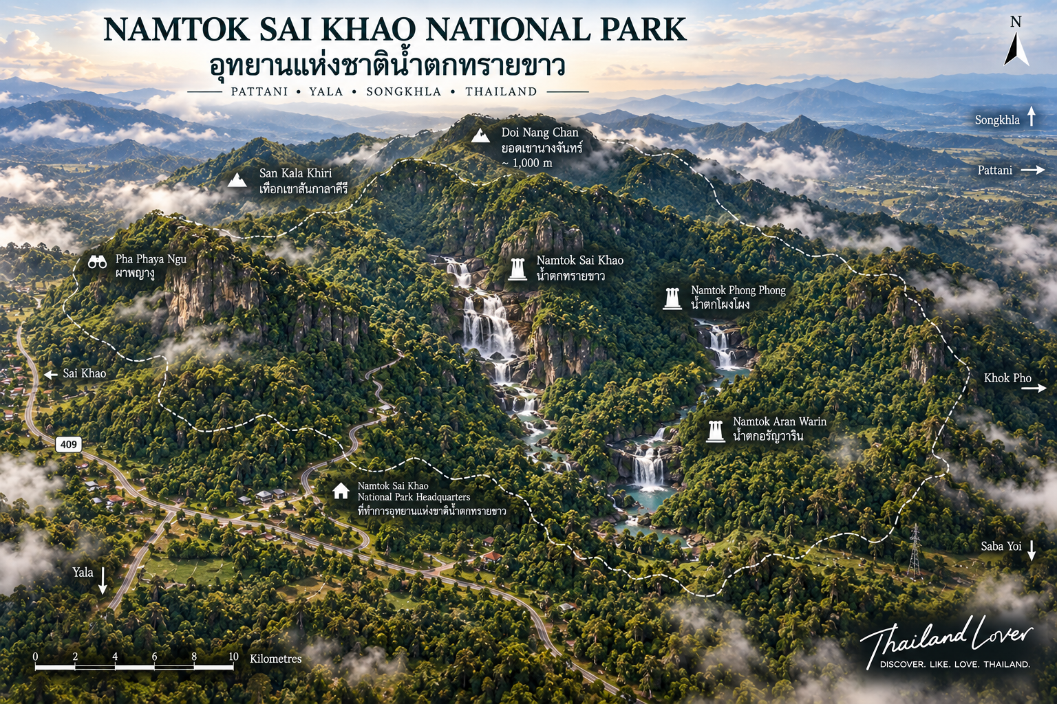
Namtok Sai Khao sits in southern Thailand, on the Sankalakhiri mountain system. The principal visitor area is in Sai Khao Subdistrict, Khok Pho District, Pattani Province. The protected landscape then extends across provincial boundaries into Pattani, Yala and Songkhla.
This makes Sai Khao unusual. The park is administratively associated with one province, but ecologically it belongs to a much larger mountain landscape.
Three Provinces, One Mountain Landscape
The park covers forest along the Sankalakhiri range — part of the natural landscape of the far south, with ridges and watersheds extending through several provinces and toward the Thai–Malaysian border region.
The forest does not stop where one provincial boundary ends. Neither does the water. Streams originating in the mountains flow downhill, join larger waterways and eventually contribute to the Thepha River system.
Sai Khao is a watershed landscape, not simply a waterfall destination.
The Sankalakhiri Mountain Range
The backbone of Sai Khao
The terrain is mountainous: ridges, steep slopes, forested valleys, streams, waterfall channels, small plateaus and rocky formations. The highest area is associated with Nang Chan Mountain, traditionally described at approximately 1,000 metres above sea level.
That elevation matters in southern Thailand. It creates cooler and wetter conditions at higher elevations and helps maintain the forest and streams below.
A mountain made of water
Rain falls on the mountain. The forest absorbs and slows it. Small streams begin, combine, then descend through valleys and over cliffs. One result is Sai Khao Waterfall. The same system produces several other streams and falls.
Follow the water
The best way to understand Sai Khao is to follow the water. The park protects an interconnected water system rather than a single attraction. The waterfall is the visible expression of the mountain.
Sai Khao Waterfall
The park’s signature attraction
Sai Khao Waterfall is the feature that gives the national park its name. It is located in Moo 5, Sai Khao Subdistrict, Khok Pho District, Pattani, formed by water descending from the mountain before falling over a cliff of approximately 40 metres.
After the main drop, the water continues through a series of natural cascades and pools. The result is a waterfall landscape rather than a single vertical curtain. DASTA’s community-based tourism database describes the main waterfall as falling from a cliff approximately 40 metres high, then continuing through descending levels to form a large natural pool.
From cliff to cascade
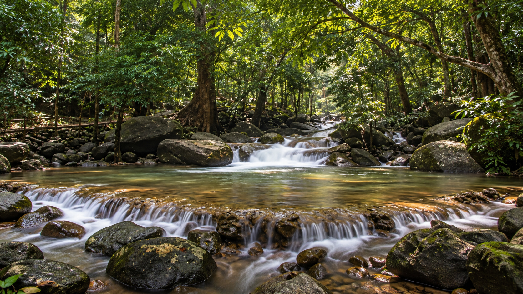
The most dramatic section is the upper drop. The lower section is where the character of the waterfall becomes more interesting: rocks divide the flow, small cascades appear, pools form, and the stream narrows and widens. For photographers, this is more useful than a waterfall that can only be viewed from one angle.
The Former Name: Takon Waterfall
Local historical accounts say Sai Khao Waterfall was formerly known as Takon Waterfall. The waterfall was reportedly discovered around 1932 (B.E. 2475) by Phra Khru Siriratthanakon, also known as Than Si Kaew, the former abbot of Sai Khao Temple.
He encouraged local residents to improve the area around the waterfall, beginning its development as a recreational destination. The site was subsequently managed under the forestry authorities before becoming part of the national-park system.
A Forest Waterfall, Not a Resort Waterfall
One of Sai Khao’s most important characteristics is its setting. The waterfall is surrounded by humid forest. There are no large urban developments around the main cascade. The sound of the water is accompanied by birds, insects, wind through trees, running streams and forest sounds.
The atmosphere is considerably more natural than many easily accessible waterfalls elsewhere in Thailand.
The waterfall pools
At the base and lower sections, the stream forms natural pools — among the most attractive places to stop and rest. Swimming conditions depend on rainfall, water level, current speed, recent weather and park safety instructions.
Never assume that a natural waterfall pool is safe simply because it looks calm. Mountain streams can change rapidly after heavy rainfall.
When Sai Khao Waterfall Is Most Impressive
The waterfall depends heavily on rainfall. During wetter months, water volume increases, the cascade becomes more powerful, the surrounding forest becomes intensely green, streams become more active, and the atmosphere becomes cooler and more humid. During drier periods, the flow may be lighter and individual rocks and channels become more visible.
There is therefore no single “best” season for everyone.
Rainy season
The most dramatic period for waterfall photography. Rain feeds the mountain; the mountain feeds the stream; the stream feeds the waterfall. The trade-off: wet rocks become slippery and stream conditions can become dangerous.
Drier months
Cooler, drier weather can be more comfortable for walking, and visibility may be better. Waterfall flow may be lower. If the waterfall is your primary objective, check current conditions before travelling.
A Waterfall Landscape, Not a One-Waterfall Park
Local tourism information describes Sai Khao as the most prominent waterfall, followed by Phong Phong and Aranyawarin. Several other streams complete the picture.
- Phong Phong Waterfall
- Seven levels of mountain water at the Th.Kh.1 Phong Phong ranger station in Pak Lo Subdistrict, Khok Pho. A large pool sits at the lowest level. From below, water winds down the cliff through forest — a very different character from Sai Khao. The stream originates in the Nang Chan mountain area. Camping has been associated with this ranger station; confirm current access before travelling.
- Phra Mai Phai Waterfall
- Associated with the park’s second ranger unit, in a more forested section. Less about a single dramatic drop, more about the network of streams that make up Sai Khao.
- Ka Dae Waterfall
- Another waterfall within the protected landscape. Official local descriptions use slightly different transliterations — Ka Dae, Kae Dae, Kae Kae. ThailandLover uses Ka Dae Waterfall unless the park publishes a preferred Romanisation.
- Aranyawarin Waterfall
- Another named waterfall in the park, often listed after Sai Khao and Phong Phong. Together they make the point: this is a waterfall landscape.
Pha Phaya Ngu
The Snake King Rock · Cliff of the Serpent King
One of the park’s most unusual geological features is Pha Phaya Ngu — a large rock formation whose shape resembles the head of a giant snake emerging from a steep rock face. DASTA describes the formation as approximately the height of a four-storey building.
Local belief holds that the rock represents a benevolent serpent spirit that protects local residents and visitors from danger. The rock is geological. The story is cultural. Neither needs to replace the other.
A natural formation with a local cultural meaning — not simply “a snake-shaped rock.”
The Forest
Humid evergreen forest
Namtok Sai Khao lies in one of southern Thailand’s humid forest environments. Vegetation is dominated by evergreen forest adapted to substantial rainfall. Historical descriptions record trees including yang, sia, krabak, kalo, lum pho, khai khiao, sataw, riang and takian thong. The understory includes rattan, ferns, vines, wild palms, orchids and other tropical plants.
Do not look at the forest as one green wall. It has layers.
- Canopy — the tallest trees capture sunlight
- Understory — smaller trees and shrubs grow below
- Forest floor — ferns, leaf litter and fungi occupy the damp ground
- Stream zone — moisture-loving plants grow around the water
- Epiphytes — orchids and other plants use larger trees as support
Wildlife, Birds & Smaller Life
Historical records associated with the area include serow, wild boar, muntjac, Malayan porcupine, mouse deer, macaques, langurs, gibbons, civets, squirrels, monitor lizards, snakes, frogs, turtles, freshwater fish, crabs and freshwater shrimp. These should be understood as recorded or historically reported wildlife, not a promise of what visitors will see. Large mammals are naturally difficult to encounter.
The serow
One of the more notable mammals associated with the mountain landscape is the serow — a goat-antelope-like ungulate adapted to steep rocky terrain. Its presence reflects the rugged character of the mountain. If you encounter one, maintain distance. Do not chase it. Do not attempt to photograph it at close range.
Birds
Historical records include hill mynas, magpies, bulbuls, hawks, cuckoos and forest songbirds. Early morning is the most sensible time: the forest is cooler, bird activity is higher, and the light is softer.
Butterflies & insects
Streams and flowering plants can be particularly productive. If you slow down, you may notice far more than you would while walking directly toward the waterfall. The forest is not empty between the major attractions.
The Watershed
Where the water begins
Namtok Sai Khao is important because it protects headwaters. The mountains give rise to streams including Huai Sai Khao, Huai Phong Phong, Huai Bon, Huai Ka Dae, Huai Lam Yang, Huai Khlong Ruea, Huai Ton Takhian, Huai Lam Ching and Huai Lam Phaya. These streams eventually contribute to the Thepha River system.
A waterfall is visible. A watershed is not. But the watershed is arguably more important. The forest stores water, slows runoff, protects soil, maintains stream flow, provides habitat and supports downstream communities.
The Sankalakhiri range also forms a significant geographic divide. Some slopes send water toward Pattani and Thepha-related waterways; others connect with watersheds farther south and west. This is one reason the mountain landscape has long been important beyond tourism.
Protecting the forest protects more than scenery. It protects water.
From Takon Waterfall to Thailand’s 110th National Park
The waterfall existed long before the national park. Around 1932, the abbot of Sai Khao Temple is credited with discovering or developing the site for local recreation. The waterfall was subsequently managed under the forestry authorities. By the late twentieth century, government agencies began surveying the surrounding forest for formal protection.
The forest was surveyed as part of an effort to establish a national park covering the Khao Yai and Sankalakhiri forest areas. One challenge was ensuring that local agricultural and settlement areas were not unnecessarily included. Government agencies worked with local administrative organisations and provincial committees to refine the boundary. The final process involved Pattani, Yala and Songkhla.
Namtok Sai Khao National Park was officially established through a Royal Decree published in the Royal Gazette, Volume 125, Part 71 Kor, dated 28 May 2008. It became Thailand’s 110th national park — relatively young compared with Thailand’s earliest parks.
The Park Today
The park is managed as a protected forest landscape with recreation, conservation and educational functions: waterfalls, forest trails, viewpoints, wildlife habitat, mountain streams, camping areas and nature study. Surrounding communities also participate in tourism-related activities. A provincial project brief specifically identifies the park as a site for ecotourism and community-linked tourism development, with the objective of generating local employment and income while promoting conservation.
The forest provides water, recreation, tourism income, educational opportunities and ecological services. Local communities provide knowledge, food, services, cultural interpretation and access to the landscape. The relationship works best when tourism benefits both sides.
A Different Kind of Southern Thailand
Visitors often associate southern Thailand with beaches, islands, diving, resorts and seafood. Namtok Sai Khao tells another story: mountain + rainforest + waterfall + watershed.
The sea is not visible from every viewpoint. But its influence is present in the climate and rainfall that keep the forest green. The park receives substantial monsoon rainfall — one of the reasons the forest remains evergreen, streams remain active, waterfalls flow, moss and ferns thrive, and humidity remains high.
The word “Sai Khao” is often translated literally as White Sand, associated with the pale appearance of streambeds and sediment around the waterfall area. ThailandLover does not present a single folk etymology as definitive unless the park provides an official explanation. What matters visually is that the pale streambed contrasts with the darker forest and rock around it.
Best Time to Visit
- November – February
- Comfortable mountain weather. Generally better for walking and combining waterfalls with longer outdoor activities.
- March – May
- Hotter conditions. The forest can still remain green, but midday hiking becomes less comfortable. Early mornings are preferable.
- June – October
- Rainforest at its greenest. Strongest waterfall conditions, fuller streams, intensely green forest — and extra caution on wet rocks and stronger currents.
For waterfalls
Rainier periods — and immediately after rain for photography.
For hiking
Cooler, drier months. For birdwatching, early morning year-round. For quiet visits, weekday mornings.
Getting There
The main Sai Khao Waterfall area can be reached from Highway 409, the Pattani–Yala route. From Highway 409, travel to the Na Pradu junction, then continue along the Na Pradu–Sai Khao road for approximately 7 kilometres toward the waterfall.
DASTA’s tourism database describes the route as approximately 28 kilometres along Highway 409 from the relevant Pattani–Yala approach, followed by approximately 7 kilometres on the local road to Sai Khao Waterfall.
- From Pattani — the main waterfall is approximately 30 kilometres from Khok Pho District according to local tourism information. The route is relatively straightforward compared with more remote mountain waterfalls.
- From Yala — approach via the Highway 409 corridor. Because the park extends into Yala, several forest areas are geographically closer to Yala than to the main Pattani visitor entrance.
- From Songkhla — the Songkhla portion lies around Saba Yoi District. Access to remote sections should not be assumed to be equivalent to access to the main Sai Khao waterfall. Always check with park officials regarding which ranger stations and trails are currently open.
How Long Should You Stay?
- Quick visit
- 1–2 hours — enough for the main waterfall area.
- Half day
- 3–5 hours — waterfall, forest walk, photography and Pha Phaya Ngu.
- Full day
- Combine Sai Khao Waterfall, a nature trail, a viewpoint and an additional waterfall area.
- Overnight
- Camping may be possible at designated sites, particularly around ranger stations such as Phong Phong, subject to current regulations and availability.
Things to Do
- 1. Visit Sai Khao Waterfall
- The essential experience — see the main drop and follow the stream downstream.
- 2. Walk along the stream
- The water is the best guide. Follow it carefully through the forest.
- 3. Visit Pha Phaya Ngu
- See the snake-shaped rock and learn the local story behind it.
- 4. Explore Phong Phong
- A seven-level waterfall with a large lower pool and a more secluded forest atmosphere.
- 5. Other waterfalls
- Depending on current access: Phra Mai Phai, Ka Dae and Aranyawarin.
- 6. Birdwatch
- Start early. Stay quiet. Watch the canopy and forest edges.
- 7. Photograph the rainforest
- Look beyond the waterfall — streams, moss, roots, ferns and shafts of light.
- 8. Hike
- Nature trails and forest routes. Check current conditions and whether a ranger or guide is required before entering remote sections.
Photography Guide
Namtok Sai Khao has a strong visual identity. Use rocks and forest as framing elements at the waterfall. Shoot the stream downstream rather than only toward the main drop. Use forest layers to create depth. Photograph Pha Phaya Ngu from a safe distance. Early mornings after rainfall can create mist.
Do not make every photograph about the waterfall. Try: waterfall → stream → forest → mountain → detail.
That sequence tells a much stronger story. The viewer begins to understand where the water comes from and where it is going.
Families, Facilities & Practical Advice
Family travel
The main waterfall area can be suitable for a nature outing. Supervise children around water, avoid slippery rocks, do not enter strong currents, follow park signs, and avoid remote trails unless properly prepared. This is a forest environment, not an amusement park.
Accessibility
The main visitor area is more accessible than remote sections. Natural terrain still means paths may include uneven ground, slopes, rocks, steps and wet surfaces. Visitors with mobility limitations should check current conditions with the park before travelling.
Facilities & camping
Facilities are concentrated around developed visitor areas. Depending on location and current operations, visitors may find parking, toilets, visitor facilities, ranger stations, rest areas, and accommodation or camping. Remote waterfalls should be treated as wilderness areas — bring what you need.
Camping has historically been associated with the park, particularly around the Phong Phong ranger-station area. Current camping availability, fees and booking procedures should be checked directly with the park before travelling.
What to bring
- Sufficient drinking water
- Shoes with grip — wet forest and waterfall rocks are slippery
- Rain jacket, especially in the wet season
- Insect repellent
- A dry bag for phone and camera
- Binoculars for birdwatching
- Snacks — do not assume remote ranger stations have food
Safety
The most important risk at Sai Khao is not the forest itself. It is water. Heavy rainfall can rapidly increase stream levels. Potential hazards include flash floods, strong currents, slippery rocks, falling branches, landslides, leeches, snakes, heat and humidity. If the park closes a trail or waterfall area, do not enter.
- Never stand directly below a waterfall after heavy rainfall
- Never cross a swollen stream simply because it looks passable
- Never climb wet rock faces for photographs
- Never underestimate water coming from higher ground
- Do not feed, chase, touch or collect animals or plants
A waterfall can change within minutes. Wildlife encounters should remain wild: stop, observe, give it space. The forest is their habitat. You are the visitor.
The Cultural Landscape
Namtok Sai Khao is surrounded by a rich cultural landscape: Sai Khao Temple, Wat Chang Hai, historic mosques, local communities, traditional southern food and rural agricultural landscapes. This creates an opportunity to experience both the natural and cultural sides of Pattani.
Sai Khao Temple
The history of the waterfall is closely associated with Sai Khao Temple, whose former abbot is credited in local accounts with developing the waterfall area in the early twentieth century. A visit to Sai Khao should not necessarily end at the waterfall. Look at the community around it.
Wat Chang Hai
For a broader Khok Pho itinerary, Wat Chang Hai Rat Burana Ram is one of the region’s important religious destinations, historically associated with Luang Pu Thuat. A natural pairing: Sai Khao’s forest landscape + Khok Pho’s religious heritage.
Why the Park Matters
The value of Namtok Sai Khao extends far beyond tourism. The park protects forest, water, wildlife, mountain ecosystems, headwaters, local recreation and scientific resources. Its forests are part of the wider Sankalakhiri mountain ecosystem.
It is one of the protected forest landscapes of Thailand’s southern border region. Its importance is increased by its position across three provinces. It provides a protected link between mountain forests that would otherwise be increasingly fragmented by roads, agriculture and settlement.
The Sankalakhiri range continues beyond provincial boundaries, part of a larger landscape extending toward Malaysia and the Thai–Malaysian frontier. For wildlife, this continuity can be crucial. For conservation, it makes cooperation between jurisdictions important.
A recreation area + a watershed + a wildlife habitat + a forest refuge.
Essential Information
- Official name
- Namtok Sai Khao National Park
- Thai
- อุทยานแห่งชาติน้ำตกทรายขาว
- Provinces
- Pattani, Yala & Songkhla
- Main visitor area
- Sai Khao Subdistrict, Khok Pho District, Pattani
- Area
- Approx. 43,482 rai / 69.57 km²
- Mountain range
- Sankalakhiri Range
- Highest area
- Nang Chan Mountain, approx. 1,000 m
- Established
- 28 May 2008 · national park no. 110
- Main attraction
- Sai Khao Waterfall · approx. 40 m main drop
- Other waterfalls
- Phong Phong · Phra Mai Phai · Ka Dae · Aranyawarin
- Geological feature
- Pha Phaya Ngu
- Forest
- Humid evergreen / tropical rainforest
- Major watershed
- Thepha River system
- Main route
- Highway 409 to Na Pradu, then ~7 km toward Sai Khao
Frequently Asked Questions
- Where is Namtok Sai Khao National Park?
- The main entrance and Sai Khao Waterfall are in Sai Khao Subdistrict, Khok Pho District, Pattani. The national park extends into Yala and Songkhla.
- How large is the park?
- The current commonly cited official area is approximately 43,482 rai, or about 69.57 km².
- When was the park established?
- Officially on 28 May 2008 — Thailand’s 110th national park.
- How high is Sai Khao Waterfall?
- The main waterfall drops from a cliff approximately 40 metres high, then continues through cascading levels and pools.
- How many levels does Sai Khao Waterfall have?
- Descriptions are not consistent. ThailandLover describes it as a main 40-metre drop followed by cascading levels, rather than a single official tier count.
- What is Phong Phong Waterfall?
- Another major waterfall in the park — a seven-level cascade with a large pool at its lowest level.
- What is Pha Phaya Ngu?
- A large rock formation resembling the head of a giant snake. Local belief describes it as a benevolent serpent spirit protecting people in the area.
- Which provinces does the park cover?
- Pattani, Yala and Songkhla.
- What mountain range is the park in?
- The Sankalakhiri Mountain Range.
- What is the highest mountain?
- The Nang Chan Mountain area is traditionally described at approximately 1,000 metres above sea level.
- Can I swim?
- Natural pools have traditionally been used for recreation, but conditions depend on weather, water level and park regulations. Check with park staff first.
- Is it suitable for families?
- The main waterfall area can work well for a family nature outing — children must be supervised around streams, pools and slippery rocks.
- Can I camp?
- Camping has been associated with the park, particularly around Phong Phong, but current availability and rules should be confirmed with park staff.
- What is the best time to visit?
- Strongest waterfall conditions during or after substantial rainfall. Easier hiking in the cooler, drier months.
More Southern Forest
- Khao Nam Khang National Park
- Misty Songkhla rainforest, waterfalls and the historical tunnel on the Thai–Malaysian border.
- Bang Lang National Park
- Yala’s vast southern rainforest, reservoir and multi-tier waterfalls.
- Budo–Su-ngai Padi National Park
- Another Deep South rainforest across three provinces — Pacho Waterfall and Golden Leaf.
- San Kala Khiri National Park
- More of the same Sankalakhiri mountain system in Songkhla.
- Thale Ban National Park
- Southern rainforest and wetland on the Satun side of the border landscape.
- All Nature & Parks
- Browse ThailandLover’s national park guides across the country.
Location
Find Namtok Sai Khao
Moo 5, Sai Khao Subdistrict, Khok Pho, Pattani — from Highway 409 via Na Pradu