


Park Spotlight · Near Bangkok
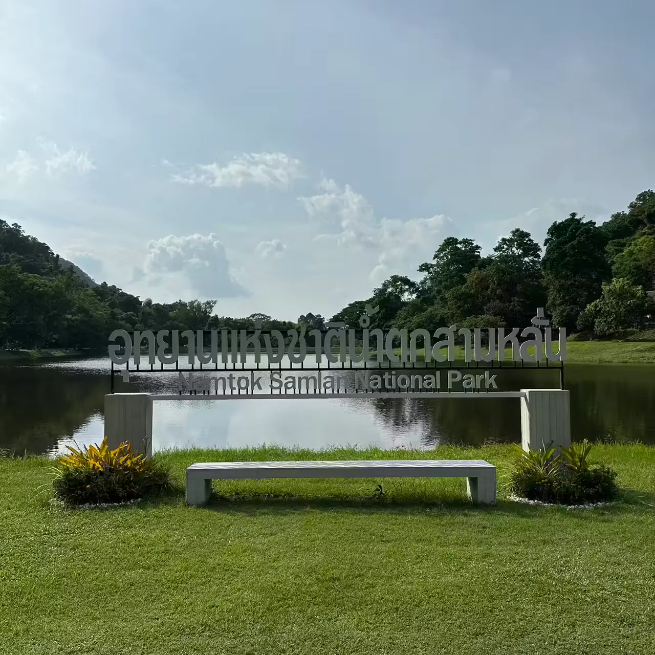
Namtok Sam Lan National Park
อุทยานแห่งชาติน้ำตกสามหลั่น
Waterfalls, Forest Trails & Quiet Mountain Landscapes Near Bangkok
There are places in Thailand where the wilderness feels impossibly far from the capital. And then there is Namtok Sam Lan National Park.
A Forest Escape Without the Expedition
Located in Saraburi Province, just beyond the urban edge of Bangkok, this compact national park protects a landscape of low mountains, forested valleys, rocky streams and seasonal waterfalls.
It is not a vast highland wilderness like Khao Yai, or a dramatic limestone landscape like some of Thailand’s southern parks. Its appeal is quieter: a genuine forest escape that can be reached without committing to a long journey.
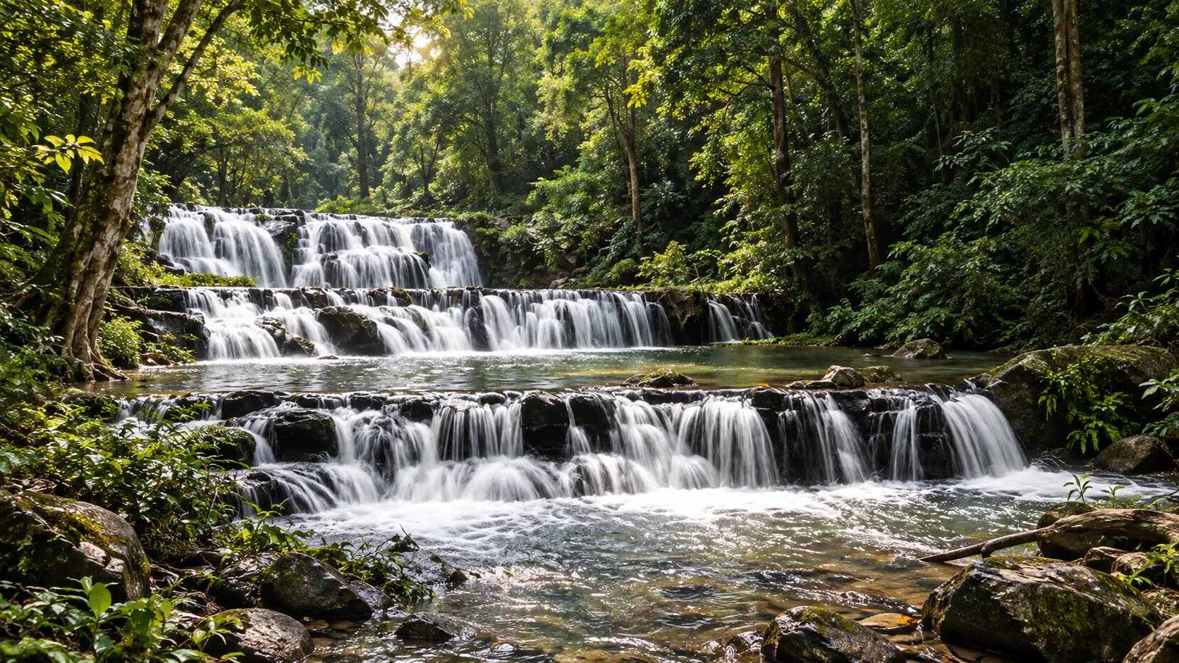
The park’s most famous feature is Sam Lan Waterfall, a broad cascade flowing over a series of natural rock shelves. Nearby are Pho Hin Dat Waterfall and Ton Rak Sai Waterfall, while the surrounding hills provide walking routes, forest scenery and viewpoints.
Today it is one of Saraburi’s most accessible nature destinations — particularly attractive for travellers looking for waterfalls, easy forest exploration, camping and a slower day away from Bangkok.
At a Glance
- 44.57 km²
- Approximately 27,856.25 rai across four Saraburi districts.
- 27th park
- Gazetted 2 June 1981 as Khao Sam Lan National Park.
- 329 m
- Khao Krok — the highest point, with views toward Saraburi.
- Day trip
- Close enough to Bangkok for a waterfall morning and a city evening.
- Official name
- Namtok Sam Lan National Park
- Thai name
- อุทยานแห่งชาติน้ำตกสามหลั่น
- Province
- Saraburi
- Districts covered
- Mueang Saraburi, Nong Khae, Wihan Daeng and Kaeng Khoi
- Area
- Approx. 27,856.25 rai · 44.57 km²
- Established
- 2 June 1981 · Thailand’s 27th national park
- Former names
- Khao Sam Lan National Park · Phra Phutthachai National Park
- Highest point
- Khao Krok, approx. 329 m
- Main attraction
- Sam Lan Waterfall
- Other waterfalls
- Pho Hin Dat · Ton Rak Sai
- Landscape
- Low mountain ranges, valleys, forest and rocky streams
- Forest types
- Mixed deciduous and dry dipterocarp forest
- Nearest major city
- Saraburi
- Best known for
- Waterfalls, camping, forest walks and accessible nature
The park currently covers approximately 27,856.25 rai, equivalent to 44.57 square kilometres, across four districts of Saraburi. The figure is supported by government and environmental references.
Where Is Namtok Sam Lan National Park?
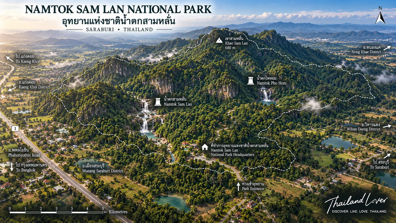
Namtok Sam Lan is in Saraburi Province in central Thailand, east of Bangkok. The protected landscape extends across parts of Mueang Saraburi, Nong Khae, Wihan Daeng and Kaeng Khoi. Headquarters and the principal visitor area are in Nong Pla Lai Subdistrict, Mueang Saraburi District.
That geography is one of its greatest advantages. Unlike many of Thailand’s larger national parks, visitors do not need to travel deep into the countryside. The park sits relatively close to Saraburi city and can be incorporated into a day trip from Bangkok — a short nature escape rather than a major expedition.
Why Is It Called Sam Lan?
The name comes from Sam Lan Waterfall, the park’s signature cascade. Water flows over a broad rocky surface divided into several descending sections. The formation resembles a series of steps or shelves.
The Thai word “Sam Lan” refers to the three-part appearance associated with the waterfall. Rather than being famous for a single enormous vertical drop, Sam Lan is characterised by the way water spreads across the rock and descends through successive levels.
This makes the waterfall especially attractive after rainfall, when the streams become more active and the surrounding forest turns intensely green.
The Story Behind the National Park
The history of Namtok Sam Lan is more complicated than its present-day name suggests. Before becoming a national park, the area was associated with Namtok Sam Lan Forest Park, inside the Phra Chai National Reserved Forest.
In the 1970s, Thailand’s forestry authorities began studying the surrounding forest for possible national-park designation. Survey reports identified a mountainous landscape with forests, streams, waterfalls and wildlife habitat. The National Park Committee supported designation, and the area was formally established as Khao Sam Lan National Park.
The proclamation was published in the Royal Gazette on 2 June 1981, making it the 27th national park of Thailand.
From Khao Sam Lan to Namtok Sam Lan
In 2000, the park was renamed Phra Phutthachai National Park, reflecting archaeological, historical and cultural associations in the surrounding landscape. The name did not remain permanently. On 31 May 2006, the Department of National Parks changed it again to Namtok Sam Lan National Park — emphasising the park’s best-known natural feature and its established tourism identity.
The Landscape
Namtok Sam Lan is not a high-altitude mountain park. Its landscape is a series of relatively low but complex hills and valleys, generally extending from northwest to southeast, with narrow plains between the hills.
The highest point is Khao Krok, rising to approximately 329 metres above sea level. Modest beside Thailand’s major mountain parks, it is significant locally because its elevated position provides views toward Saraburi town and the surrounding area.
The visitor experience is not about conquering a high summit. It is about moving gradually between forest, rock, streams, waterfalls and small mountain viewpoints.
Khao Krok viewpoint
For landscape photography, Khao Krok is one of the park’s more interesting elevated locations. During the Second World War, the high ground was reportedly used by Japanese military forces as an observation point — a historical layer noted in government planning documents.
ThailandLover treats this as a layer of the landscape rather than presenting the viewpoint primarily as a war-history attraction. The forest remains the main experience. Sunrise, late afternoon and periods of atmospheric haze are particularly interesting.
Three Waterfalls, One Compact Landscape
- Sam Lan Waterfall
- The signature fall, close to headquarters. Water flows across a wide rocky platform divided into descending sections — broad and horizontal rather than towering. Surrounding rocks create natural places to sit and photograph. Sam Lan is a seasonal waterfall. After rain it becomes considerably more impressive; in drier periods volume can decline substantially. If the waterfall is your primary reason for visiting, recent rainfall matters more than a particular month.
- Pho Hin Dat Waterfall
- A short distance from headquarters — government planning material places it roughly 300 metres away. Smaller than Sam Lan, with water flowing over a relatively low rocky area surrounded by vegetation and large trees. A quieter stop. The name refers to the rocky landscape around the fall.
- Ton Rak Sai Waterfall
- Associated with a short forest route from the main park area. Water drops from a rocky cliff of approximately 7 metres into a pool below. Large rocks around the pool provide natural sitting places. Planning material places it approximately 400 metres from headquarters — a small forest waterfall, not a major trekking destination.
The Forest & the Rocks
Namtok Sam Lan protects a relatively compact forest ecosystem surrounded by heavily developed central Thailand. That geographic context makes the forest particularly important.
Vegetation includes mixed deciduous forest, dry dipterocarp forest, bamboo-dominated areas, riparian vegetation around streams and smaller patches of denser woodland. Recorded trees include Siamese rosewood, Burma padauk, dipterocarp species, teng, rang, takhian thong, makha mong and tabaek. Composition changes with elevation, soil, moisture and disturbance history.
This is not a tropical rainforest in the southern humid-evergreen sense. Its character is typical of central Thailand’s seasonal forest landscape.
Geology
Soils include clayey and sandy-loam types; underlying formations include shale. That combination contributes to broad rock surfaces and shallow cascades rather than only tall vertical falls.
For photographers
The attraction is not simply water falling from a cliff. It is the interaction between water + layered rock + forest + seasonal light.
Wildlife, Birds & Small Details
Namtok Sam Lan is not a large-mammal safari destination. Its relatively small size and proximity to urban and agricultural areas mean visitors should not expect encounters comparable with Khao Yai.
Recorded animals include wild boar, barking deer, mouse deer, macaques, junglefowl, pheasants, squirrels, small mammals, numerous birds, butterflies and other insects. These should be understood as recorded or reported wildlife, not guaranteed sightings. Birdlife is particularly noticeable — you may hear the forest even when animals remain hidden.
Birdwatching
The combination of seasonal forest, streams, waterfalls, bamboo, mixed woodland and open edges creates different habitats in a small area. Early morning is generally better than midday. Bring binoculars rather than relying only on a long zoom.
Butterflies & insects
After rainfall, insect activity can increase considerably. Macro photographers may find butterflies, moths, beetles, dragonflies, forest insects and fungi around damp ground and fallen wood. Walk slowly. Look down. Look at stream edges.
The champagne mushroom
One unusual natural subject associated with the park is the “champagne mushroom”, also called a cup fungus — small fungi in vivid pink, red, orange or reddish-orange, sometimes on dead branches. Their cup-like shapes can resemble miniature champagne glasses. They are seasonal and should never be collected. Government and provincial tourism material specifically identifies them as a nature subject found in the park.
Water: The Hidden Importance of the Park
The waterfalls are visually attractive, but the park’s ecological importance goes beyond tourism. The hills and forest act as a watershed. Rain falling on the forest moves through small streams and drainage channels before continuing into the surrounding agricultural landscape.
Forest → rainfall absorption → streams → downstream water → agriculture and communities.
Protecting relatively small forest areas near cities still matters. This one supports both biodiversity and the hydrological system around Saraburi.
What to Do
- 1. Visit Sam Lan Waterfall
- The obvious starting point. Visit after rainfall if stronger flow is your priority.
- 2. The other waterfalls
- Combine Sam Lan with Pho Hin Dat and Ton Rak Sai for three perspectives on the same water landscape.
- 3. Walk the forest
- An accessible introduction to central Thailand’s seasonal forests. Observe vegetation, rocks, insects and birdlife.
- 4. Photograph Khao Krok
- The highest point offers a different perspective from the waterfalls.
- 5. Camp overnight
- Daytime is waterfalls and trails. At night the forest becomes quieter — insects, frogs and nocturnal sounds. Confirm current arrangements before travelling.
- 6. Macro details
- After rain, look for fungi, moss, insects and small forest subjects. Macro work can be more rewarding here than only photographing the main fall.
A better slow-travel sequence: waterfall → forest → small details → viewpoint → sunset → camp.
Best Time to Visit
There is no single best month for every traveller. The ideal timing depends on what you want to see.
- October – January
- Cool season. Generally more comfortable for walking and camping. The forest may be less intensely green than peak rainfall, but conditions can be pleasant.
- February – April
- Hot season. Temperatures rise and waterfall flow can become lower. Less reliable if the waterfall is your main objective.
- May – September
- Rainy season. Greatest potential for strong waterfall flow and a lush forest. Trails and rocks become slippery; streams can turn dangerous after heavy rain.
For waterfalls
Rainy season, or the period shortly after rainfall.
For walking & camping
The cooler months. For photography, after rain: darker rocks, saturated green, possible mist, more visible fungi and insects.
How to Get There
Namtok Sam Lan is relatively easy to reach by road. From Bangkok, travellers generally head toward Saraburi via Phahonyothin Road / Highway 1, then continue through the Saraburi road network toward the park. Road access is one of the park’s major advantages.
Because recommended routes can change, ThailandLover recommends using current navigation data immediately before departure rather than relying solely on a static description. For international visitors without a car, private transport or a local taxi/ride from Saraburi is usually more practical than infrequent public transport.
Can you visit from Bangkok in one day?
Yes. That is one of the defining characteristics of Namtok Sam Lan — particularly with a private car or hired driver.
- Morning — Bangkok → Saraburi → the park
- Late morning — Sam Lan Waterfall
- Lunch — picnic or local food
- Afternoon — Pho Hin Dat → Ton Rak Sai → forest walk
- Late afternoon — Khao Krok area, then return toward Saraburi
- Evening — back to Bangkok
If you dislike rushed itineraries, an overnight camping trip is a better way to experience the park.
Camping, Accommodation & Facilities
Camping is one of the park’s practical attractions. Accessible terrain and proximity to Bangkok make it suitable for visitors who want to try camping without travelling deep into remote wilderness.
Before camping, confirm whether the camping area is open, whether tents are available for rent, whether you may bring your own tent, current fees, fire restrictions, water availability, seasonal closures and weather. These details change. ThailandLover does not hard-code camping prices into evergreen content unless they have been confirmed directly from the park for the current season.
Stay in the park
Camping or park accommodation can provide a more immersive experience — night sounds, cooler air, a slower morning.
Stay in Saraburi
Hotels and resorts around the city offer greater convenience and make it easier to combine the park with cultural and historical attractions.
Facilities associated with the park include visitor areas, parking, toilets, recreational areas and camping. Because this is a relatively accessible national park, do not expect wilderness-style remoteness — and do not assume every service operates continuously. Confirm camping, park rooms, shops, equipment rental and seasonal waterfall access if those are why you are travelling.
Safety, What to Bring & Responsible Travel
The waterfalls may look gentle, but the rocks can become extremely slippery — particularly after rainfall.
- Do not stand directly beneath strong currents
- Do not climb wet rock faces
- Do not enter pools when water levels are rising
- Do not walk across slippery rocks barefoot
- Do not enter streams during thunderstorms or flash-flood conditions
A stream that looks harmless in dry weather can become dangerous after heavy rain. If park officials close an area, follow the closure immediately.
What to bring
- Drinking water, comfortable walking shoes, quick-drying clothing
- Hat, sunscreen, insect repellent, a small first-aid kit
- Waterproof bag, camera, binoculars, power bank
- Light rain jacket in the wet season
- For camping: tent, sleeping gear, headlamp, toiletries, food, waterproof storage
Responsible travel
Namtok Sam Lan is a relatively small protected area. Visitor behaviour matters more here than in a remote wilderness.
- Take rubbish out, or use designated waste facilities
- Do not collect mushrooms, plants, rocks or wildlife
- Do not feed animals or play loud music in forest areas
- Stay on designated routes; do not carve names into trees or rocks
- Follow seasonal closures and camping regulations
Namtok Sam Lan vs Khao Yai
These two destinations should not be treated as substitutes. Khao Yai is a huge protected landscape with much greater ecological scale, elevation and wildlife habitat. Namtok Sam Lan is much smaller and closer to urban areas.
Choose Sam Lan if you have a day
A waterfall, forest, short walks, camping and a quiet nature break — without turning the journey into an expedition.
Choose Khao Yai for scale
Large-scale wildlife viewing, long trekking routes, extensive mountain landscapes and multi-day exploration.
Sam Lan is particularly suitable for families, weekend travellers, campers, beginner hikers, photographers and anyone who wants a compact example of central Thailand’s seasonal forest. Travellers seeking extreme wilderness may find it too accessible. That is not a flaw. Its strength is nature without excessive travel time.
Nearby Experiences & Photography
A visit can be combined with other attractions around Saraburi. One of the most notable nearby cultural destinations is Wat Phra Phutthachai, whose name is closely connected with the park’s former identity as Phra Phutthachai National Park. Combining the park with Saraburi’s cultural landscape can turn a short waterfall visit into a broader central Thailand experience.
- Sam Lan Waterfall — wide-angle to capture waterfall and forest together
- Water movement — a slower shutter when flow is sufficient
- Rocks — layered surfaces as strong foregrounds
- Forest details — fungi, moss, leaves, insects, bark, small streams
- Khao Krok — wider landscape from the high point
Essential Information
- Official name
- Namtok Sam Lan National Park
- Thai
- อุทยานแห่งชาติน้ำตกสามหลั่น
- Province
- Saraburi
- Districts
- Mueang Saraburi, Nong Khae, Wihan Daeng, Kaeng Khoi
- Area
- 27,856.25 rai / 44.57 km²
- Established
- 2 June 1981 · national park no. 27
- Highest point
- Khao Krok, approx. 329 m
- Main waterfall
- Sam Lan Waterfall
- Other waterfalls
- Pho Hin Dat · Ton Rak Sai
- Main activities
- Waterfalls, nature walks, photography, birdwatching, camping
- Best waterfall period
- Rainy season and periods following rainfall
- Best for walking
- Cooler season
- Nearest major city
- Saraburi
- Day trip from Bangkok
- Yes
- Main route
- Highway 1 / Phahonyothin toward Saraburi, then local roads to Nong Pla Lai
Frequently Asked Questions
- Where is Namtok Sam Lan National Park?
- In Saraburi Province, covering parts of Mueang Saraburi, Nong Khae, Wihan Daeng and Kaeng Khoi. Headquarters are in Nong Pla Lai, Mueang Saraburi.
- How far is it from Bangkok?
- Close enough to make a practical day trip by road.
- When was the park established?
- As Khao Sam Lan National Park on 2 June 1981 — Thailand’s 27th national park.
- Was it always called Namtok Sam Lan?
- No. Originally Khao Sam Lan, later Phra Phutthachai, then renamed Namtok Sam Lan on 31 May 2006.
- How large is the park?
- Approximately 27,856.25 rai / 44.57 km².
- What is the highest mountain?
- Khao Krok, approximately 329 metres.
- What is the main attraction?
- Sam Lan Waterfall — a broad cascade over descending rock shelves.
- Are there other waterfalls?
- Yes — Pho Hin Dat and Ton Rak Sai.
- Can you swim?
- Only where the park permits it. Avoid streams during heavy rain or rapidly rising water.
- Is the waterfall open all year?
- Attractions can close seasonally. Water flow varies considerably with rainfall. Sam Lan is a seasonal waterfall.
- Can you camp?
- Yes — an established activity, subject to current rules and availability.
- Is it suitable for children?
- Main visitor areas can work for families. Supervise children closely around rocks, streams and waterfalls.
- Can I see wildlife?
- Wildlife is present, never guaranteed. Birds and smaller forest animals are more realistic than large mammals.
- What should I bring?
- Water, comfortable shoes, insect repellent, sun protection, rain protection and a waterproof bag.
More Central Thailand Nature
- Namtok Chet Sao Noi National Park
- Seven cascades on the Muak Lek stream — another accessible waterfall landscape from Saraburi.
- Khao Yai National Park
- The large neighbouring wilderness — for wildlife, long trails and a fundamentally different scale.
- Pang Sida National Park
- Eastern forest and waterfalls in the same broader central–east landscape.
- Thap Lan National Park
- A much larger protected forest further east, for travellers who want more space.
- All Nature & Parks
- Browse ThailandLover’s national park guides across the country.
Location
Find Namtok Sam Lan
53 Moo 1, Nong Pla Lai, Mueang Saraburi — off Highway 1 / Phahonyothin toward Saraburi