


National Park · Saraburi & Nakhon Ratchasima
Namtok Chet Sao Noi National Park
อุทยานแห่งชาติน้ำตกเจ็ดสาวน้อย
Seven Cascades. One River. A Landscape Shaped by Water.
Muak Lek · Wang Muang · Pak Chong
Where the Muak Lek stream turns seven low rock terraces into a living landscape of water, forest and stone.
A River Landscape, Not Just a Waterfall
Namtok Chet Sao Noi National Park is one of Thailand’s most accessible waterfall landscapes — but its appeal goes beyond a popular swimming spot.
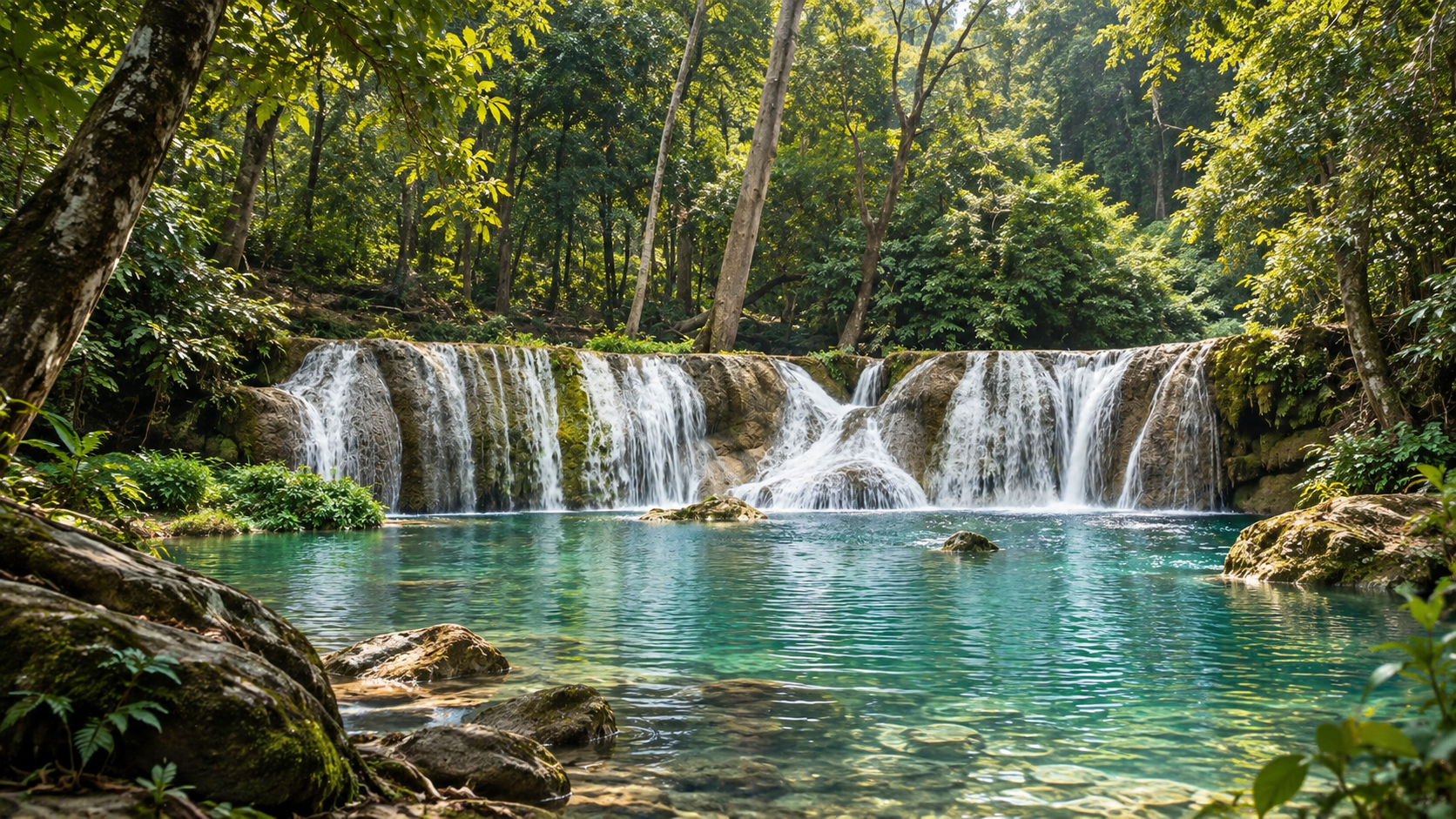
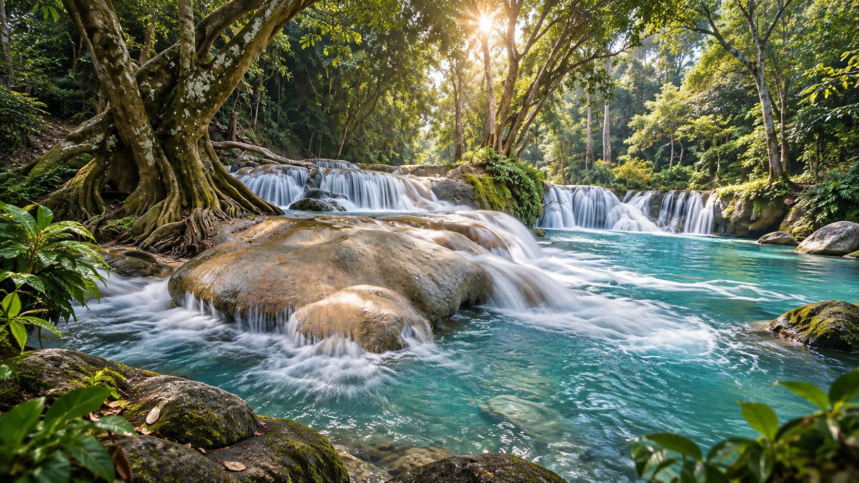
At the heart of the park, the Muak Lek stream moves across a broad sequence of natural rock shelves, creating seven low cascades rather than one dramatic vertical drop. Water spreads across the rock, gathers in shallow pools, disappears beneath the forest canopy and continues downstream.
The result feels remarkably different from Thailand’s high-mountain waterfalls. Here the experience is horizontal rather than vertical: a river, limestone and rock terraces, forest shade, shallow pools and a continuous sound of moving water.
The park also tells a larger story about landscape restoration. Much of the present forest has developed through rehabilitation and natural regeneration, transforming land that was once significantly disturbed into a protected landscape.
For ThailandLover, Chet Sao Noi is best understood not simply as “a waterfall near Bangkok”, but as a river landscape where geology, water, forest recovery and recreation meet.
At a Glance
- Official English Name
- Namtok Chet Sao Noi National Park
- Thai Name
- อุทยานแห่งชาติน้ำตกเจ็ดสาวน้อย
- Location
- Saraburi and Nakhon Ratchasima, Thailand
- Main Districts
- Muak Lek & Wang Muang (Saraburi); Pak Chong (Nakhon Ratchasima)
- Established
- 26 December 2016
- National Park Number
- 129th national park of Thailand
- Original Protected Area
- 26,238 rai / approximately 41.98 km²
- Former Status
- Chet Sao Noi Forest Park (est. 21 May 1980)
- Main Watercourse
- Muak Lek stream
- Signature Attraction
- Chet Sao Noi Waterfall · seven main levels
- Typical Height per Level
- Approximately 2–4 m (some sources 2–5 m)
- Waterfall Sequence
- About 490 metres
- Geological Setting
- Sandstone, shale, chert and limestone
- Landscape Character
- Low mountains, plains, recovering forest, perennial stream
- Telephone
- +66 36 346 586
The park was formally established on 26 December 2016 under a Royal Decree and became Thailand’s 129th national park. The officially established area was approximately 26,238 rai, covering protected land in both Saraburi and Nakhon Ratchasima.
Why Chet Sao Noi Is Different
Thailand has many spectacular waterfalls. Some are defined by height. Others by volume, dramatic cliffs or remote mountain settings.
Chet Sao Noi belongs to a different category. Its character comes from breadth, repetition and the movement of water across rock.
Instead of falling hundreds of metres, the Muak Lek stream descends through a succession of relatively low rock terraces. Each level creates a small change in elevation, producing cascades, shallow pools and broad sheets of water.
The entire sequence extends for approximately 490 metres from the first to the seventh level. Individual levels are generally low, with published official environmental information describing heights of approximately 2–4 metres.
This is why the waterfall can feel more like a natural river park than a conventional cliff waterfall.
The Muak Lek Stream
The River Is the Real Main Character
The story of Chet Sao Noi begins upstream. The Muak Lek stream is the principal watercourse associated with the park and is central to both its ecology and its landscape.
Historical forestry records describe the stream as originating from the mountainous area around Khao Yai in Pak Chong before flowing through the Muak Lek landscape and eventually joining the Pa Sak River near Wang Muang.
Within the national park, the stream provides a permanent source of water through a landscape that is otherwise relatively dry. Surrounding terrain contains low mountains and plains, with relatively shallow soils and areas that can become dry. Along the stream, moisture creates a different microenvironment: greener vegetation, aquatic plants, shade and a cooler atmosphere.
The river therefore acts as an ecological corridor through the landscape.
Chet Sao Noi Waterfall
Seven Low Cascades Along the Muak Lek Stream
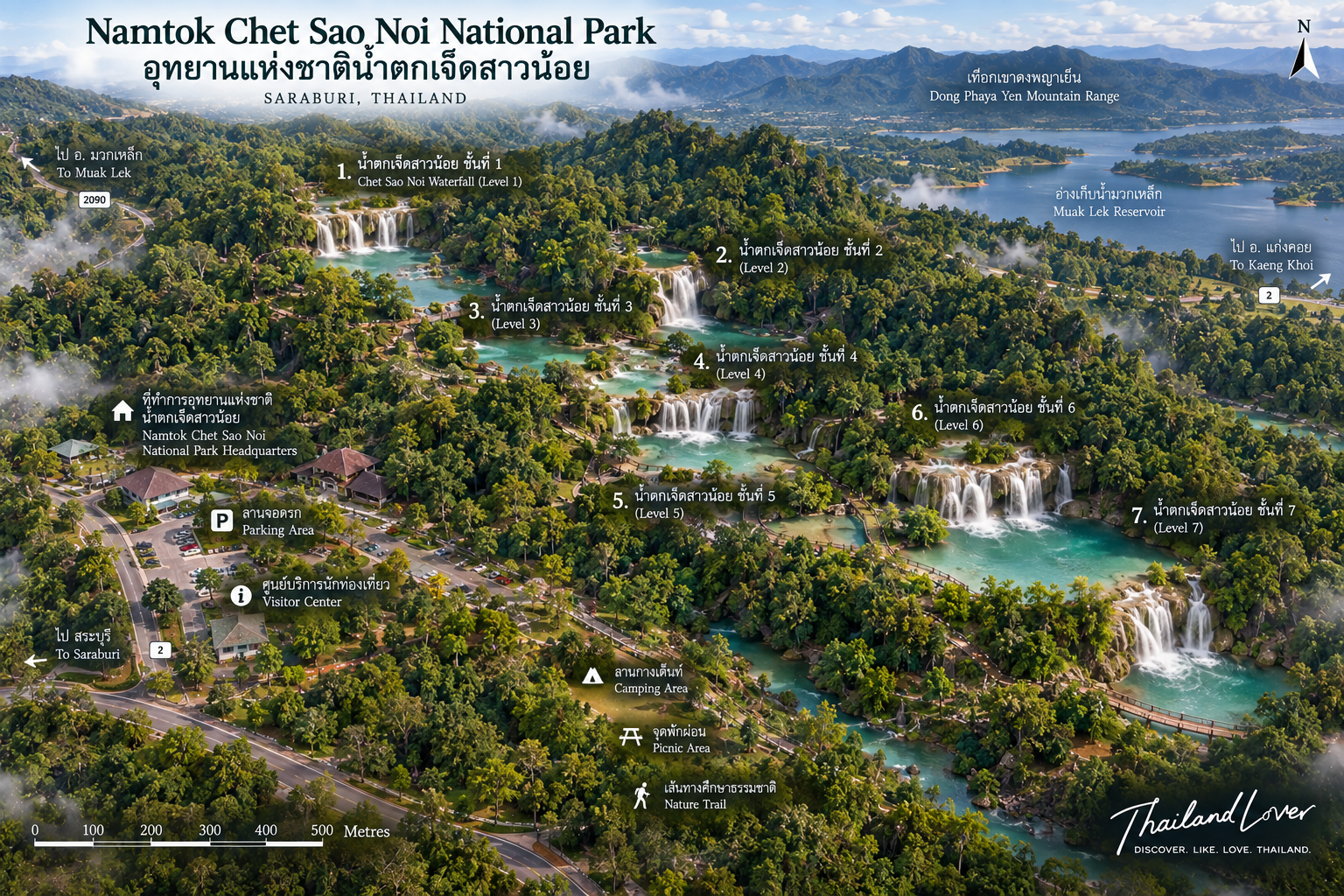
The signature attraction consists of seven main levels, formed where the Muak Lek stream passes across a sequence of natural rock terraces.
Each level is relatively low compared with Thailand’s major mountain waterfalls. Official environmental information records individual drops of approximately 2–4 metres, while tourism materials commonly describe them as approximately 2–5 metres. The waterfall sequence extends for roughly 490 metres.
The fourth level is widely regarded as one of the most visually attractive sections because its approximately four-metre drop creates a broad curtain of water over the rock shelf.
The seven levels are not isolated waterfalls. They form a connected sequence along the same stream.
Water falls. · It spreads. · It gathers. · It flows again. · And then the landscape repeats.
That rhythm is what gives Chet Sao Noi its character.
Understanding the Seven Levels
The seven levels should not be interpreted as seven enormous individual waterfalls. They are better understood as seven principal stages in one continuous cascade system.
The stream repeatedly drops over low rock shelves, creating pools and shallow channels between levels. This structure explains why the waterfall is popular for recreation: the landscape naturally creates numerous places where water slows down and spreads across relatively broad rock surfaces.
Water conditions change continuously. A low-flow period can make the terraces appear gentle and shallow, while heavy rainfall can transform the same stream into a significantly stronger and more dangerous flow.
The park has repeatedly used temporary closures as a safety measure during heavy rainfall and flash flooding. In August 2026, for example, the park temporarily closed Levels 1–7 and Koh Si Chang Waterfall after heavy rainfall caused the Muak Lek stream to rise rapidly and flow strongly.
The Geology Behind the Waterfall
A Waterfall Built on Rock Structure
Chet Sao Noi’s form is controlled by the geological structure beneath and around the river. Thailand’s Natural Environment information system identifies sandstone, shale, chert and limestone within the geological sequence associated with the waterfall area.
The stream encounters rock layers and surfaces with different resistance to erosion. Over long periods, flowing water exploits weaknesses, joints and variations in rock hardness. Softer sections wear down faster; harder surfaces remain as shelves.
The result is not a single deep gorge. Instead, the landscape develops a succession of relatively low steps.
This is the geological reason Chet Sao Noi looks more like a broad natural staircase than a towering waterfall.
A Landscape of Shallow Pools
One of the most recognizable characteristics of Chet Sao Noi is the series of pools created beneath the cascades. The relatively low vertical drops allow water to spread over the rock before collecting in pools and continuing downstream.
Rock → Water → Pool → Rock Shelf → Cascade → Pool
Repeated throughout the waterfall system, this sequence creates unusually accessible scenery. Visitors do not need to stand far from a huge vertical waterfall to experience the landscape. Much of the attraction can be appreciated from close to the stream.
That accessibility is one reason Chet Sao Noi became such a popular recreational destination long before it was upgraded from forest park to national park.
The Story Behind the Name
Why “Chet Sao Noi”?
The name Chet Sao Noi literally refers to “Seven Little Girls” or “Seven Young Girls.” It combines the number of waterfall levels with the local place name associated with Ban Sao Noi, a settlement located north of the waterfall.
Historical explanations in tourism and local materials connect the discovery of the seven-level waterfall with the nearby village, producing the memorable name. It is therefore not simply a poetic name invented for tourism.
It reflects both the physical structure of the waterfall and the local geography surrounding it.
From Forest Park to National Park
A Long Transition
Chet Sao Noi was not originally established as a national park.
- 5 September 1978
- Forestry authorities surveyed the waterfall area with the intention of establishing a forest park. The original surveyed area was approximately 500 rai, later adjusted through land-status considerations and additional surveys.
- 21 May 1980
- Formally established as Chet Sao Noi Forest Park, covering approximately 540 rai at the time. Visitor numbers grew steadily thereafter.
- 2002 onward
- The Forest Department recognized that the area and management framework should be reconsidered — expanding protection along the watershed and undertaking broader ecological and management studies.
- 26 December 2016
- Elevated to national-park status as Thailand’s 129th national park.
A National Park Born from Landscape Restoration
One of the less obvious stories of Chet Sao Noi is forest recovery. The park’s present landscape is not uniformly old-growth forest.
Government environmental planning documents describe substantial areas as forest that has been rehabilitated through planting and forest that is recovering naturally. This reflects the area’s earlier history of disturbance and land degradation.
Bamboo-dominated areas, planted forest, naturally regenerating forest and riparian vegetation form a mosaic across the park.
The national park therefore represents more than the preservation of an untouched landscape — it also represents a continuing process of ecological recovery.
The Forest
A Recovering Forest Landscape
The park is characterized by a mixture of forest and open areas rather than one continuous mature forest type. Government environmental information identifies areas of bamboo, recovering forest and vegetation associated with the Muak Lek stream.
The riparian environment is particularly important. Plants recorded in wetter areas include water-associated trees and shrubs, aquatic plants, ferns, rattan and other moisture-dependent vegetation.
The contrast between dry upland areas and the greener river corridor is one of the defining ecological characteristics of the park.
Rare Plants
Sirindhorn’s Champak
One of the more remarkable botanical records associated with the park is Sirindhorn’s Champak (Magnolia sirindhorniae).
Government environmental planning information identifies the species as a rare plant recorded at only two locations in Thailand in the cited source: Sap Champa in Lopburi, and Namtok Chet Sao Noi National Park.
Chet Sao Noi is not simply a recreational waterfall. It is part of a protected ecological landscape with botanical value.
Wildlife
A Small Park with More Wildlife Than the Waterfall Suggests
Although Chet Sao Noi is highly accessible and receives substantial recreational use, the wider protected area provides habitat for wildlife. Government environmental documents record species including:
- Serow (Capricornis sumatraensis) — a protected wild mountain ungulate
- Sunda pangolin / Malayan pangolin (Manis javanica)
- Golden jackal (Canis aureus)
- Red giant flying squirrel
- Malayan porcupine
Birds
- Greater racket-tailed drongo
- Black-winged kite
- Collared scops owl
- Rosy minivet
- Large racket-tailed drongo
These records describe wildlife documented within the wider park landscape — not a guarantee that visitors will encounter them during an ordinary waterfall visit.
Beyond the Seven Cascades
Pha Nam Yot
A Seasonal Cliff Landscape
Government environmental planning information identifies Pha Nam Yot, a cliff approximately 30 metres high. During the rainy season, water emerges or drips from the cliff and breaks into fine spray, creating a seasonal waterfall-like effect.
Unlike Chet Sao Noi, which is defined by a permanent stream system, Pha Nam Yot is more strongly associated with seasonal water conditions — an example of how the park changes character between dry and wet periods.
Siritep Waterfall
A Smaller Water Feature within the Park
Siritep Waterfall is considerably less famous than Chet Sao Noi and should not be presented as a second equivalent to the main waterfall. Its importance lies in showing that the park’s hydrological landscape extends beyond the seven principal cascades.
Koh Si Chang Waterfall
Another Waterfall in the Park
Koh Si Chang Waterfall offers a quieter alternative within the park’s broader water landscape. Recent safety announcements specifically included both Chet Sao Noi Waterfall Levels 1–7 and Koh Si Chang Waterfall — demonstrating that both sites are managed as part of the same protected area and subject to the same weather-related safety considerations.
The Bridge Between Two Regions
Where Central Thailand Meets Isan
One of the more unusual features associated with the destination is the “Bridge Across Regions”, a pedestrian crossing associated with the boundary between Saraburi and Nakhon Ratchasima.
The Muak Lek stream forms part of the geographic boundary between the two provinces. A visitor can physically cross from the Central Thailand side into the northeastern side of the country while following the same river landscape.
Chet Sao Noi is therefore not merely a waterfall in one province — it sits at a meeting point between Saraburi and Nakhon Ratchasima, and between two major geographic regions of Thailand.
Two Provinces, One Protected Landscape
- Saraburi Province
- Muak Lek District · Wang Muang District
- Nakhon Ratchasima Province
- Pak Chong District
- Gazetted Area
- Approximately 26,238 rai · about 41.98 km² at national-park establishment
Landscape and Elevation
Chet Sao Noi is not a high-elevation mountain park. Its terrain consists primarily of low mountain ranges, hills, plains, stream valleys and recovering forest.
- Waterfall Elevation
- Approximately 180 m above mean sea level
- Highest Point in Park
- Approximately 402 m above mean sea level
It is a lowland-to-low-mountain waterfall landscape rather than a high-altitude wilderness destination.
The Waterfall and the Seasons
When the Landscape Changes
- Wetter Periods
- The Muak Lek stream becomes fuller; cascades become more powerful; surrounding vegetation becomes greener; smaller seasonal water features become more visible.
- Drier Conditions
- Water flow can decrease; rock terraces become more exposed; pools can appear calmer; the waterfall takes on a more recreational character.
A waterfall can be beautiful under low flow and spectacular under higher flow — but high water can also make it dangerous.
Water Safety Is Part of the Experience
Chet Sao Noi is often associated with swimming and recreation, but the park’s river is a natural water system. Conditions can change quickly. Heavy rainfall upstream can increase water volume and current strength even when conditions immediately around the waterfall appear manageable.
On 31 August 2026, following heavy overnight rainfall, the park temporarily closed all seven levels of Chet Sao Noi Waterfall and Koh Si Chang Waterfall because the Muak Lek stream had risen rapidly and become dangerously strong. The closure lasted one day while officials assessed water levels and site conditions.
Never judge waterfall safety by appearance alone. Always follow current instructions from park officials.
Best Time to Experience the Landscape
- Greener Landscapes & Stronger Water
- The rainy season can produce the most dramatic river conditions — and the greatest flash-flood risk.
- Comfortable Outdoor Recreation
- The cooler months generally offer more comfortable conditions for walking and exploring the park.
- Swimming
- Warmer months can be attractive for cool freshwater recreation, but water conditions should always be checked before entering.
The best approach is not simply to choose a month. It is to choose a safe water condition.
Accessibility
One of Chet Sao Noi’s defining characteristics is accessibility. Unlike remote waterfall destinations that require long treks through mountainous terrain, the principal waterfall area has established visitor infrastructure and walking routes — including infrastructure designed to improve access for visitors with disabilities.
Chet Sao Noi therefore works particularly well for:
- Families
- Older travellers
- Casual nature visitors
- Photographers
- Visitors travelling with children
- Travellers who want a nature experience without a long mountain hike
TAT also presents Chet Sao Noi as an accessible Saraburi destination and describes its seven-level stream waterfall and shaded recreational areas.
What to Expect on Arrival
Chet Sao Noi is not the kind of national park where the visitor experience begins with a long expedition. The experience is immediate.
You arrive. · You hear the water. · You enter the shaded landscape. · Then the stream begins to reveal itself through the trees.
The main waterfall area is relatively easy to explore, and the sequence of pools and cascades creates numerous viewpoints. The most attractive approach is not to rush directly to one “best” viewpoint.
Walk. Follow the water. Observe how the character of the stream changes from one level to another.
Photography
Photograph the Water, Not Just the Waterfall
Chet Sao Noi is particularly well suited to photography because of its layered landscape. Instead of photographing only a vertical cascade, try to include:
- The entire width of the stream
- Rock terraces
- Reflections in the pools
- Forest canopy
- People providing scale
- Bridges and pathways
- Flowing water crossing the rock shelves
The fourth level is traditionally regarded as one of the most photogenic sections of the main waterfall.
For a more editorial ThailandLover image, avoid treating the location simply as a “swimming waterfall.” The stronger story is water moving through a recovering forest landscape.
A Different Kind of National Park
Chet Sao Noi does not compete with Thailand’s great wilderness parks on remoteness or altitude. That is not its purpose. Its strength is different. It combines:
Accessibility · Geology · Water · Forest restoration · Recreation · Cross-provincial geography
This makes it an excellent example of a national park where conservation and public recreation exist side by side.
Practical Visitor Notes
Before You Go
Because Chet Sao Noi is a river-based attraction, conditions can change rapidly after heavy rain. Check the park’s latest official announcement before travelling, particularly during the rainy season.
Do not rely solely on an old travel blog for opening status, swimming conditions, temporary closures, entrance fees or activity availability. These operational details can change.
Entrance Fees
Historical DNP fee schedules have listed:
- Thai adults
- THB 20
- Thai children
- THB 10
- Foreign adults
- THB 100
- Foreign children
- THB 50
These rates were introduced following the park’s national-park designation. Because park fees and categories can be revised, verify the current DNP rate before treating any published price as a permanent fact.
Opening Hours
Open according to current park operating conditions. Check official announcements before travelling. The national park can temporarily suspend access to the waterfall during severe weather, flooding or safety assessments.
Getting There
Chet Sao Noi National Park is located in the Muak Lek area of Saraburi, with the wider protected area extending into Wang Muang District and Pak Chong District in Nakhon Ratchasima.
The destination is particularly accessible from the Bangkok metropolitan area and is frequently incorporated into Saraburi and Muak Lek itineraries. Tourism Authority of Thailand itineraries place Chet Sao Noi alongside other Saraburi attractions and describe the waterfall as being reached via the Muak Lek route.
For international visitors, a private car or hired vehicle is generally the most flexible option because the wider national park contains multiple sites rather than a single urban attraction.
How Long Should You Spend?
- Quick Visit · 1–2 Hours
- Enough to see the main waterfall and walk through the principal visitor area.
- Relaxed Visit · Half a Day
- Better for walking, photography, sitting beside the stream and exploring the waterfall sequence without rushing.
- Full-Day Nature Itinerary
- Combine the national park with other attractions around Muak Lek and Saraburi. Treat Chet Sao Noi as a nature destination, not simply a photo stop.
What to Bring
- Lightweight clothing
- Walking shoes or footwear suitable for wet surfaces
- Swimwear if swimming is permitted
- A change of clothes
- Drinking water
- Sun protection
- Waterproof protection for cameras and phones
- Small towel
- Insect protection
Most importantly: do not enter the water when park officials prohibit swimming or when currents are visibly strong.
Responsible Travel
Chet Sao Noi is a heavily visited natural area. The simplest way to protect it is also the most important:
- Leave No Litter
- Take rubbish out when required.
- Do Not Damage Vegetation
- Stay on designated routes where requested.
- Do Not Disturb Wildlife
- Do not feed, chase or attempt to handle wild animals.
- Respect the River
- Do not use soap, shampoo or other substances in the natural stream.
- Follow Temporary Closures
- A closed waterfall is not an inconvenience — it is a safety and conservation decision.
Frequently Asked Questions
- What is Namtok Chet Sao Noi National Park?
- Thailand’s 129th national park, established on 26 December 2016. It covers about 26,238 rai (41.98 km²) across Saraburi and Nakhon Ratchasima and is known for the seven-level Chet Sao Noi Waterfall on the Muak Lek stream.
- How many levels does Chet Sao Noi Waterfall have?
- Seven main levels along one continuous cascade sequence of roughly 490 metres, with typical individual drops of about 2–4 metres.
- Where is the park?
- Muak Lek and Wang Muang districts in Saraburi, and Pak Chong District in Nakhon Ratchasima. The Muak Lek stream forms part of the provincial boundary.
- Is it good for families?
- Yes — the principal waterfall area is relatively accessible and suited to families, older travellers and visitors who want nature without a long mountain trek. Always check current water and safety conditions.
- Can you swim?
- Only where and when park rules permit. Never enter during strong currents or temporary closures. On 31 August 2026 the park closed Levels 1–7 and Koh Si Chang Waterfall after the Muak Lek stream rose rapidly.
- What are the entrance fees?
- Historical DNP schedules list Thai adults THB 20, Thai children THB 10, foreign adults THB 100 and foreign children THB 50. Verify the current DNP rate before travelling.
- When is the best time to visit?
- Choose a safe water condition rather than a fixed month. Rainy season can mean stronger flow and higher flood risk; cooler months are often more comfortable for walking.
- What else is there besides the main waterfall?
- Koh Si Chang Waterfall, Siritep Waterfall, the seasonal cliff feature Pha Nam Yot, recovering forest, rare plants such as Sirindhorn’s Champak, and the Bridge Across Regions between the two provinces.
Related Destinations
- Khao Yai National Park
- The great mountain forest upstream of the Muak Lek watershed — Thailand’s pioneering UNESCO World Heritage landscape.
- Thap Lan National Park
- Expansive protected forest in Nakhon Ratchasima’s Isan highlands.
- Namtok Chat Trakan National Park
- Another seven-tier waterfall story — this time in the sandstone mountains of Phitsanulok.
- Nature & Parks
- More protected landscapes across ThailandLover’s national-park collection.
Location
Find Namtok Chet Sao Noi National Park
Muak Lek, Saraburi · Pak Chong, Nakhon Ratchasima