



National Park · Northern Thailand
Phu Soi Dao National Park
อุทยานแห่งชาติภูสอยดาว
Pines, mist, wildflowers and a mountain camp earned on foot
Uttaradit · Phitsanulok · Northern Thailand
A highland world of three-needle pines, misty trails, wildflowers, waterfalls and one of Thailand’s most memorable mountain camps.
A Landscape You Walk Into
Phu Soi Dao National Park is one of northern Thailand’s great highland landscapes. Straddling Uttaradit and Phitsanulok, it protects approximately 340.21 square kilometres of mountainous forest, watersheds, pine woodland and high-elevation grasslands.
Its most famous destination is the Phu Soi Dao Three-Needle Pine Plateau — a highland campsite surrounded by pine trees and seasonal wildflowers. Getting there is part of the experience. From park headquarters, hikers follow a 6.5-kilometre mountain trail through dense forest and five major uphill sections before reaching the pine plateau at approximately 1,633 metres.
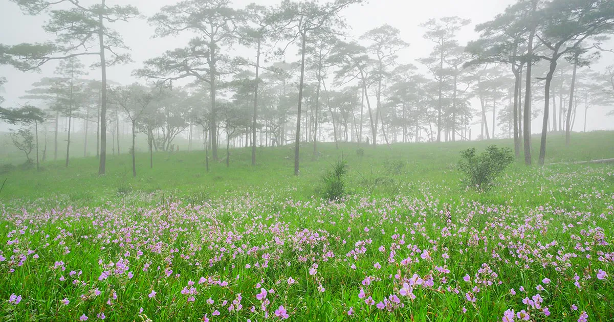
During the rainy season, the grassland becomes famous for purple Murdannia gigantea, locally known as Dok Ngon Nak. Mist moves through the pine trees, waterfalls strengthen, and the mountain takes on a completely different character.
For experienced hikers, another challenge waits beyond the plateau: the 2,102-metre Phu Soi Dao summit, reached by a separate, more demanding route when the park officially opens the activity.
This highland trek is a standout destination in ThailandLover’s Nature & Parks collection — not a mountain to conquer in a hurry, but a landscape to experience slowly.
One forest step. One wildflower. One cloud at a time.
At a Glance
- Official Name
- Phu Soi Dao National Park
- Thai Name
- อุทยานแห่งชาติภูสอยดาว
- Region
- Northern Thailand
- Provinces
- Uttaradit & Phitsanulok
- Area
- Approximately 340.21 km² / 212,633 rai
- Highest Summit
- Phu Soi Dao — approximately 2,102 m
- Pine Plateau
- Approximately 1,633 m
- Landscape
- Mountain forest, pine forest, grassland, waterfalls and highland ecosystems
- National Park Status
- Established by Royal Decree in 2008
- Signature Experience
- 6.5-km trek to the Three-Needle Pine Plateau
- Best Known For
- Pine forest, wildflowers, mist, waterfalls and highland trekking
Why Visit Phu Soi Dao?
Phu Soi Dao feels different from many of Thailand’s better-known mountain destinations. There are no cable cars. No paved road takes you to the pine plateau. No large resort sits among the trees. To reach the heart of the landscape, you have to walk.
The trail climbs through forest before opening onto a broad highland of three-needle pine trees, grasses, wildflowers and enormous skies. In the rains, purple flowers appear among the grasses. In cooler months, the landscape becomes quieter and colder, with morning mist often drifting across the plateau. At night, the absence of city lights creates a natural setting for looking up at the stars.
The journey is demanding enough to feel like an adventure. The reward is not simply reaching the top — it is spending time in a landscape that feels remarkably far from the lowlands.
The Phu Soi Dao Mountain Range
Phu Soi Dao forms part of a rugged mountain system along the Thai–Lao border. Terrain ranges from approximately 500 metres to more than 1,800 metres across much of the park. The mountains form an important watershed, feeding streams including the Nam Pat and Nam Khan systems.
Approximately 85% of the park is mountainous and forested; the rest is relatively level. As you climb, vegetation changes. Lowland forest gives way to cooler, wetter mountain forest, then high-elevation pine woodland and grassland.

The Three-Needle Pine Plateau
ลานสนสามใบ · Lan Son Sam Bai · approximately 1,633 m
The signature landscape of Phu Soi Dao is the Three-Needle Pine Plateau. Spread across more than 1,000 rai of natural highland, it is rolling terrain of three-needle pine trees, grasses and seasonal wildflowers.
There are no permanent hotels here. Visitors who stay overnight camp in the designated area. You arrive carrying your equipment — or arrange for porters — and spend the night beneath the pine trees. That simplicity is part of the attraction.
The 6.5-Kilometre Trek
Five major climbs · typically 4–6 hours uphill
The trail from the Phu Soi Dao Waterfall area to the pine plateau is approximately 6.5 kilometres. Most hikers take around 4–6 hours, depending on fitness, weather, trail conditions and pack weight. It is not technical mountaineering, but it is physically demanding.
- 1. Noen Song Yat
- The first major climb — an early indication that this is considerably more than an ordinary nature walk.
- 2. Noen Prap Sian
- The steepest and most famous section. Hikers often slow down and take longer breaks here.
- 3. Noen Pa Ko
- Forest dominated by Ko trees. Compared with the previous climb, the terrain can feel more manageable.
- 4. Noen Suea Khrong
- A long uphill associated with tiger trees and increasingly open mountain vegetation.
- 5. Noen Morana
- The final major climb before the pine plateau. The land remains steep, but the landscape begins to open.
Exact conditions change with weather and trail maintenance. In the rainy season, mud and slippery surfaces can significantly increase difficulty.
Wildflower Season
ดอกเงือกนาค · Dok Ngon Nak · Murdannia gigantea
Phu Soi Dao is particularly famous for Dok Ngon Nak, the purple wildflower Murdannia gigantea. During the rainy season, the flowers emerge across the grassland of the pine plateau — a contrast of green grasses, dark pine trunks, mist and grey mountain skies.
The main flowering period is generally around August–September, although timing and intensity vary with rainfall. In 2026, park-area updates reported flowers beginning to bloom in early August — a reminder that actual conditions shift from year to year.
The flowers are small and delicate. They are best appreciated at ground level rather than treated as a backdrop to walk through.
- Other highland plants
- Soi Suwanna, fragrant grasses, small seasonal ground flowers, orchids and other highland species. Cooler months bring different plants into view; some areas may show colourful foliage, including red maple leaves. Exact species and periods vary with elevation, rainfall and temperature.
Waterfalls
- Phu Soi Dao Waterfall
- A five-tier cascade at the lower visitor area — one of the park’s most accessible attractions. Traditional names: Phu Soi Dao, Sakaeo Duean, Muean Fan, Kannika and Supaporn. Fed by mountain streams, it is described by government tourism information as flowing throughout the year. It sits beside Highway 1268, close to headquarters — forest and waterfall without the long climb.
- Sai Thip Waterfall
- A smaller, more intimate seven-tier waterfall associated with the higher mountain landscape. Individual drops are generally around 5–10 metres. The surrounding forest is particularly moist; moss grows across rocks beside the stream. Access can vary with weather — follow current park instructions.
Forest Ecosystems
Several forest communities change with elevation, which is why the park feels ecologically diverse despite a relatively compact visitor area.
- Three-Needle Pine Forest
- Above approximately 1,400 metres, large areas of three-needle pine (Pinus kesiya) occur naturally — the ecosystem that gives the high plateau its look. The forest floor holds grasses and seasonal ground flowers.
- Hill Evergreen Forest
- Above approximately 1,000 metres, cooler, wetter conditions support oak and other highland plants. Ferns, orchids, ginger relatives and epiphytes are common.
- Lower-Elevation Forest
- Mixed forest communities adapted to warmer, more seasonal conditions in the foothills.
Wildlife
Species reported from the wider landscape include forest mammals, birds and other mountain fauna. Visitors may encounter wild boar, muntjac, smaller forest mammals, birds, butterflies, reptiles and amphibians.
Large-animal sightings are unpredictable. Treat encounters as a privilege, not a guaranteed attraction. Keep food secured, never feed animals, and maintain a safe distance.
The Thai–Lao Border
A mountain landscape between two countries
Phu Soi Dao lies along the Thailand–Laos border. The ridge forms part of the natural frontier. A border marker in the highland has become one of the landmarks of the trek.
The marker has particular historical significance because this border landscape was also affected by the 1987–1988 Ban Rom Klao conflict between Thailand and Laos. Today the area is primarily experienced as a protected mountain landscape.
Follow park instructions around the border. Never cross into restricted areas.
The 2,102-Metre Summit
Beyond the pine plateau
The 2,102-metre Phu Soi Dao summit is a separate challenge from the standard trek to the 1,633-metre pine plateau. When the park opens the summit activity, it is organised as a special multi-day trek.
A 2024 government-announced program, for example, involved a 3-day, 2-night itinerary, with an additional approximately 3-kilometre summit route from the pine plateau and a long ascent and descent on the same day.
Do not treat the two experiences as equivalent. The summit route has separate annual arrangements, safety requirements and capacity limits. Always check the current year’s announcement before planning around it.
Camping on the Pine Plateau
There are no conventional hotels on the pine plateau. Visitors stay in tents in the designated camping area. The park provides tent-related services; equipment can also be carried by porters.
Current DNP reservation information states that registration for the pine plateau is available during a designated morning window, closing at 13:00. Visitors arriving after the cutoff are not permitted to register for the ascent. Porter and equipment-carrying fees are separate.
Sunrise, Sunset & Stars
- Sunset
- Late-afternoon light moves across pine trees and grassland. Open terrain gives wide views toward distant ranges.
- Sunrise
- Early morning can bring low clouds and mist between the trees. Temperatures can be significantly lower than in the lowlands — a warm sleeping system is essential.
- Stargazing
- High elevation and a remote setting offer an open horizon and comparatively little artificial light on clear nights. Cloud, fog and rain can completely obscure the sky in the rainy season. Treat stargazing as an opportunity, not a guarantee.
Best Time to Visit
- July–August
- Forest intensely green. Waterfalls generally at their most impressive. Rain, mud and slippery trails are common. First wildflowers begin appearing.
- August–October
- Classic wildflower season. Dok Ngon Nak and other seasonal flowers can turn the plateau purple-and-green. Mist is common. For many visitors, the most visually distinctive period.
- November–January
- Cooler and drier. Morning mist around the pine forest. Annual opening of the plateau can vary — check the latest park announcement.
- February–June
- The pine plateau is normally closed for seasonal environmental recovery. This is conservation, not merely an inconvenience. Dates can change by year.
- July–August
- Green forest, strong waterfalls, early wildflowers, frequent rain
- August–October
- Purple Dok Ngon Nak, mist, lush grassland
- November–January
- Cooler weather, pine forest, morning mist, clearer mountain views
- February–June
- Seasonal closure of the pine plateau for environmental recovery
Is Phu Soi Dao Difficult?
The answer depends on which experience you choose.
- Waterfall area · Easy to moderate
- The main waterfall is accessible without the highland trek.
- Pine plateau · Moderate to challenging
- The 6.5-kilometre ascent takes approximately 4–6 hours and includes several steep sections. Fitness matters, particularly when carrying camping equipment.
- 2,102-metre summit · Challenging
- Substantially more demanding, operated as a special activity under park supervision. Follow the year’s eligibility and safety requirements rather than assuming the route is always available.
How to Prepare
Do not judge the trek solely by its 6.5-kilometre distance. The important factor is elevation gain combined with steep terrain.
- Train with stairs or uphill walking
- Practice hiking with a loaded backpack
- Break in your hiking shoes
- Prepare for rain even when the forecast looks uncertain
- Start early enough to reach the plateau safely
- Keep a steady pace rather than climbing quickly
- Take regular short breaks
- Follow instructions from park staff
The goal is not to reach the top as fast as possible. The goal is to reach it safely.
What to bring
- Essential
- Hiking shoes with grip, rain jacket, warm layers, headlamp, water bottle, personal medicines, small first-aid kit, sunscreen, insect repellent, dry bags, portable power bank.
- Overnight camping
- Sleeping bag suitable for cool mountain nights, sleeping mat, tent if not renting one, warm clothing, food and snacks, cooking equipment where permitted. Avoid overpacking — every kilogram becomes heavier on the steep sections.
Photography Guide
- Pine forest
- Use tall pine trunks as vertical lines. Early-morning mist can create atmospheric depth.
- Wildflowers
- A low camera position works particularly well. Avoid stepping into flower patches for a better composition.
- Waterfalls
- Wet conditions provide rich greens around Sai Thip. Use caution on slippery rocks.
- Sunrise
- Arrive at your viewpoint before sunrise rather than moving through the campsite in the dark without a headlamp.
- Night sky
- Use a tripod and protect equipment from moisture and condensation. Cloud conditions can change quickly at high elevation.
How to Get There
The principal visitor entrance and trek starting point are in Huai Mun Subdistrict, Nam Pat District, Uttaradit Province. The park also extends into Chat Trakan District, Phitsanulok. The final approach to the visitor centre is via Highway 1268.
For independent travellers, a private vehicle or rental car is generally the most practical option. The park is remote compared with major northern cities — plan fuel, food and accommodation accordingly. If you intend to hike to the pine plateau, arrive with enough time to complete registration before the daily cutoff.
Where to Stay
The main park area provides accommodation and camping facilities. On the pine plateau, visitors generally camp rather than stay in permanent rooms.
Travellers who do not plan to camp can use accommodation around Nam Pat, Uttaradit or other nearby towns and visit the lower park attractions. For the full Phu Soi Dao experience, an overnight stay on the pine plateau is what allows sunset and sunrise in the same landscape.
Travel Tips
- Respect the annual closure — do not attempt to enter the plateau during recovery periods
- Register early: current DNP information specifies a morning window and a 13:00 cutoff for the ascent
- Pack light — steep terrain makes extra weight surprisingly tiring
- Use a porter if needed; services are available
- Prepare for rain: the famous flower season overlaps with the wet months
- Protect the flowers — stay on appropriate paths and never pick them
- Leave no trace — carry waste out
- Follow border restrictions; never cross barriers or markers
Essential Information
- Park
- Phu Soi Dao National Park — Uttaradit & Phitsanulok, Thailand
- Area
- Approximately 340.21 km² / 212,633 rai
- Pine Plateau
- Approximately 1,633 m
- Phu Soi Dao Summit
- Approximately 2,102 m
- Main Trek
- Approximately 6.5 km to the pine plateau
- Typical Trek Time
- Approximately 4–6 hours uphill
- Main Forests
- Three-needle pine, hill evergreen and other natural forest communities
- Three-Needle Pine Plateau
- Highland grassland and pine landscape at approximately 1,633 metres.
- Dok Ngon Nak Wildflowers
- Purple seasonal flowers that typically appear during the rainy season.
- Phu Soi Dao Waterfall
- A five-tier waterfall near park headquarters.
- Sai Thip Waterfall
- A seven-tier waterfall surrounded by moist forest and moss-covered rocks.
- 2,102-Metre Summit
- A separate, more demanding high-altitude route operated only during designated periods.
- Thai–Lao Border Landscape
- A mountain frontier with historical significance.
- Pine-forest Camping
- An overnight experience beneath the three-needle pines.
Frequently Asked Questions
- Where is Phu Soi Dao National Park?
- Northern Thailand, across Uttaradit and Phitsanulok. The main entrance and trek start are in Huai Mun, Nam Pat District, Uttaradit, via Highway 1268. The park also extends into Chat Trakan, Phitsanulok.
- How difficult is the trek to the pine plateau?
- Moderate to challenging. About 6.5 kilometres with five major uphill sections. Most hikers take 4–6 hours. Not technical mountaineering, but physically demanding — especially with camping gear.
- When do Dok Ngon Nak wildflowers bloom?
- Generally around August–September, depending on rainfall. In 2026, park-area updates reported blooms beginning in early August.
- Is the pine plateau open year-round?
- No. It is normally closed from about February to June for environmental recovery. For 2026, the tourism season opened from 1 July 2026. Confirm dates every year.
- Can I visit without hiking to the plateau?
- Yes. Phu Soi Dao Waterfall, a five-tier cascade beside Highway 1268 near headquarters, is accessible without the highland trek.
- What is the 2,102-metre summit?
- A separate, more demanding route beyond the 1,633-metre pine plateau, typically run as a special multi-day activity when the park opens it. Check the current year’s announcement.
Related Destinations
- Namtok Chat Trakan National Park
- Seven-tier waterfall country in neighbouring Phitsanulok — a natural pairing with Phu Soi Dao’s lower falls.
- Lam Nam Nan National Park
- Uttaradit’s reservoir-and-ridge landscape around Sirikit Dam — a different scale of northern water country.
- Phu Hin Rong Kla National Park
- Phitsanulok highland sandstone, history and cool-season forest — another northern mountain with a slower story.
- Thung Salaeng Luang National Park
- Savanna grassland and pine country further into Phitsanulok’s interior highlands.
Location
Find Phu Soi Dao National Park
Huai Mun · Nam Pat · Uttaradit · Chat Trakan · Phitsanulok · Northern Thailand