


National Park · Phrae & Uttaradit
Lam Nam Nan National Park
อุทยานแห่งชาติลำน้ำน่าน
Where Mountains Meet the Water
Forests · Mountains · Sirikit Reservoir
A ThailandLover guide to a quieter northern landscape — forested mountains, streams, waterfalls and the vast waters of Sirikit Reservoir, stretching across Phrae and Uttaradit.
Forests, Mountains & the Great Reservoir
Where mountain forests meet the vast waters of Sirikit Reservoir, Lam Nam Nan National Park is one of northern Thailand’s more quietly compelling landscapes.
Stretching across Phrae and Uttaradit, the park combines rugged mountain ranges, dry and evergreen forests, streams, waterfalls and the immense reservoir created by Sirikit Dam. It is not defined by a single dramatic summit or one iconic waterfall. Lam Nam Nan is about the relationship between forest, water and mountain terrain.
It is a landscape best experienced slowly: following a forest road toward a viewpoint, walking a short nature trail, watching the mountains dissolve into the reservoir, or taking a boat out among the islands and rocky formations of the lake.
For ThailandLover, this is not simply a place to check in. It is a destination for travellers who want to understand how northern Thailand’s forests and waterways come together.
At a Glance
- 999.15 km²
- The park’s published area — 624,468 rai.
- 1,350 m
- Phu Phaya Pho, the highest point.
- 2 provinces
- Phrae and Uttaradit, one mountain landscape.
- 2 nature trails
- Study routes of about 2.5 km and 4 km.
- 1998
- Established as Thailand’s 87th national park.
- Official Name
- Lam Nam Nan National Park
- Thai Name
- อุทยานแห่งชาติลำน้ำน่าน
- Location
- Phrae & Uttaradit, Northern Thailand
- Administrative Areas
- Primarily Mueang Phrae District, Phrae; Tha Pla and Nam Pat, Uttaradit
- Officially listed area
- 999.15 km² / 624,468 rai
- Highest Point
- Phu Phaya Pho — 1,350 m
- Established
- 30 September 1998 · National Park No. 87
- Landscape
- Mountain ranges, forest, streams, waterfalls and reservoir
- Major Water Feature
- Sirikit Reservoir
- Signature Experience
- Mountain-and-reservoir landscapes
- Nature Trails
- 2.5 km and 4 km
- Best-known Viewpoints
- Pa Daeng, Nam Kruai and Lam Nam Nang Phaya routes
- Main Waterfalls
- Choeng Thong · Huai Mun · Doi Pha Mok
- Main Water Landscape
- Sirikit Reservoir · Kaeng Nang Phaya · Ko Nom Sao
- Park Headquarters
- Pha Lueat Subdistrict, Tha Pla District, Uttaradit
- Contact
- +66 90 604 7793
The Landscape
Lam Nam Nan occupies a broad mountainous landscape above and around the northern part of Sirikit Reservoir. One side is dominated by forested mountains. The other opens toward a huge body of water created by Sirikit Dam.
The result is a distinctly northern Thai sequence:
- Layered mountain ridges and forested slopes
- Streams, small waterways and waterfalls
- Rocky rapids and reservoir islands
- Forest viewpoints and long views across the water
The forests matter beyond scenery. They form part of the watershed feeding the surrounding river systems and the reservoir above Sirikit Dam. Government information describes the area as a watershed associated with the Yom River system in Phrae and tributary waters flowing toward the Nan River system in Uttaradit.
Lam Nam Nan is more than a scenic destination. Its forests are part of a much larger hydrological landscape.
Two Provinces, One Mountain Landscape
The park extends across Phrae and Uttaradit, linking two provinces through a continuous landscape of mountains and forest.
- The Phrae side
- Forest around the Mae Kham, Mae Kon and Mae Sai landscapes — mountain roads, viewpoints and Choeng Thong.
- The Uttaradit side
- The right bank of the Nan watershed, with Mae Charim and Nam Pat forest areas, and the park headquarters above the reservoir.
The relationship between the two provinces becomes especially visible around Phu Phaya Pho, the park’s highest point. At about 1,350 metres, it forms a natural high point along the boundary between Phrae and Uttaradit.
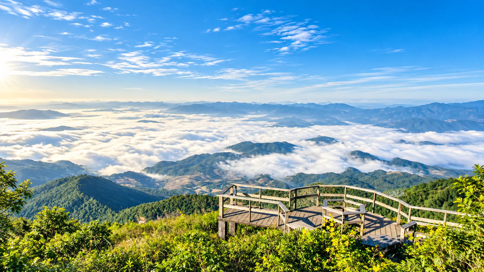
Phu Phaya Pho
The high point between Phrae and Uttaradit · 1,350 m
Phu Phaya Pho is the highest point in the park and one of the clearest expressions of its mountainous character. It lies along the route between Choeng Thong and Kiu Khian, rising above the surrounding forest with expansive views toward Sirikit Reservoir.
Its significance is not only elevation. It is also the geographical meeting point between Phrae and Uttaradit, which makes the summit landscape particularly meaningful within the park.
For travellers interested in mountain scenery rather than conventional tourist attractions, this is one of the landscapes worth seeking out. Access can vary with weather and road conditions. Check locally before attempting remote routes.
Sirikit Reservoir
The water landscape of Lam Nam Nan
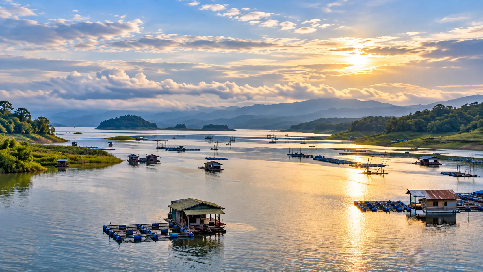
The most visually defining feature of the park is the Sirikit Reservoir. Created by Sirikit Dam, it extends through a mountainous landscape where forested ridges rise directly from the water.
It does not look like a conventional lake. It feels more like a flooded mountain valley, with islands, inlets and rocky formations breaking the surface. That is the park’s strongest visual sequence:
Mountains, then forest, then water, then islands, then distant ridges.
The reservoir is particularly attractive for scenic boat trips, photography, sunrise and sunset, watching mountain silhouettes change, relaxing beside the water, camping near the shore, and simply seeing how the forest and the lake belong together. The Tourism Authority of Thailand identifies the reservoir as one of the park’s principal attractions, and notes its islands and formations as suitable for sightseeing by boat.
Ko Nom Sao
An island with a distinctive shape
Ko Nom Sao is one of the recognisable features within the reservoir. Its name refers to a shape that resembles a woman’s breast. It is best understood as part of the wider reservoir experience, not as a standalone attraction.
From a boat, the island becomes one element in a larger composition of open water, forested mountains, scattered islands, changing light and distant ridgelines. Photographers like it because the landscape changes considerably with the time of day and the weather. The Tourism Authority of Thailand specifically identifies Ko Nom Sao and the surrounding reservoir among the park’s scenic attractions.
Suriyan–Chantra Lake Viewpoint
Sunrise, moonlight and mountain water
One of the more evocative viewpoints associated with Lam Nam Nan is the Suriyan–Chantra Lake Viewpoint. The name refers to the relationship between the sun and the moon — fitting a landscape where the reservoir becomes a natural mirror for changing light.
- Early morning
- Soft mountain silhouettes, low mist, reflected light, quiet water and changing colour across the ridges.
- Clear evenings
- The same water takes on a completely different character. Stay for the light, not only the viewpoint sign.
This is one of the places where Lam Nam Nan works best as an atmospheric destination rather than a checklist destination.
Kaeng Nang Phaya
Water, rock and forest
Kaeng Nang Phaya is a rocky rapid landscape on the Lam Nam Nang Phaya watercourse. Small and larger rock formations create a series of natural rapids, with water passing through forest.
When water levels are suitable, the combination is exposed rock, flowing water, forest, shade, and natural pools. Government tourism information describes it as a scenic rocky formation with water flowing throughout the year.
As with every natural water environment here, conditions can change significantly in the rainy season. Follow current instructions from park staff.
The Waterfalls
Lam Nam Nan’s waterfalls share a theme: small waterways supported by healthy forest catchments. Do not judge them by height. Their appeal is the surrounding forest and the seasonal water landscape. They work better as part of a broader day of forest roads, viewpoints and mountains than as destinations that require an entire day on their own.
Choeng Thong Waterfall
Choeng Thong is on the Phrae side, in the Cho Hae area of Mueang Phrae District. It is not a giant waterfall. That is precisely why it fits this park. The attraction is flowing water, forest and a relatively intimate setting, not vertical scale. Local tourism information describes clear, cool water and natural pools, with water flowing through the year under normal conditions. It suits a relaxed nature visit more than a search for a dramatic multi-tiered fall.
Huai Mun Waterfall
Huai Mun is another smaller waterfall in the same forest story. Together with Choeng Thong and Doi Pha Mok, it shows what the catchments support. Water levels vary through the year, so the visual character can change substantially between dry and wet periods.
Doi Pha Mok Waterfall
Doi Pha Mok is another natural waterfall identified within the park. Like the others, its character depends strongly on rainfall and seasonal flow. The surrounding forest is as important as the fall itself. These sites are the chance to leave the reservoir and experience Lam Nam Nan from a more intimate forest perspective.
Nature Trails
Two short routes for a closer look at the forest
The park provides two nature-study trails, approximately 2.5 km and 4 km. Both are designed to bring visitors closer to the forest while opening viewpoints across the surrounding landscape and Sirikit Reservoir. They suit travellers who want more than a roadside stop, but are not looking for a full-day expedition.
- Forest vegetation and changing terrain
- Viewpoints toward the reservoir
- Birdlife, seasonal flowers and natural streams
Trail conditions change with rainfall, maintenance and season. Always check locally before setting out.
Forest Ecology
The park’s ecological character is shaped by elevation, seasonal climate and its position in a major watershed. Government information identifies several major forest types.
- Dry dipterocarp forest
- Adapted to a pronounced dry season, and often more open in dry periods. Common in drier northern landscapes.
- Mixed deciduous forest
- A seasonally changing forest, with a marked difference between wet and dry months.
- Hill evergreen forest
- Found at higher, cooler elevations. This is the park’s more humid mountain environment.
- Dry evergreen forest
- More structurally dense than dry dipterocarp, and greener through much of the year.
Together, these forests create a landscape that changes considerably with elevation and season.
Wildlife & Birds
Lam Nam Nan provides habitat for a range of forest wildlife. Government and local administrative information describes species such as barking deer, deer, wild boar and bear, along with numerous birds. One local government source notes that more than 200 bird species have been recorded in the wider park landscape.
Wildlife should be understood as part of the ecosystem, not as a guaranteed visitor attraction. Seeing a wild animal is never something visitors should expect or attempt to force.
Walk slowly, keep noise low, remain on established routes, and let the forest come to you.
Birdwatching
The park is particularly interesting for travellers who enjoy birds. Mature forest, streams, the reservoir edge, mountain slopes and seasonal vegetation create different habitats within relatively close proximity. Early morning is generally the most rewarding period. Serious birdwatching needs binoculars, and more time than a conventional sightseeing itinerary.
Seasons
Lam Nam Nan changes character through the year.
March – May · Hot season
The landscape becomes warmer and drier. This period can be good for reservoir scenery, boat trips, early-morning photography, sunrise, and selected waterfalls and streams where water remains. Midday can be hot, particularly in exposed areas.
ThailandLover verdict: good for water-based landscapes, but plan outdoor time around the cooler parts of the day.
June – September · Green season
Rain transforms the forest. The landscape becomes greener, wetter, more atmospheric, and more dramatic around streams and waterfalls. It is a good season for nature study. Rain can also affect roads, trails, waterfall access, visibility and mountain routes.
ThailandLover verdict: one of the most beautiful seasons for the forest, but flexibility is essential.
October – February · Cool season
This is arguably the most comfortable period. Cooler temperatures make hiking, camping, photography, viewpoints and reservoir exploration more pleasant. Early mornings can lay atmospheric layers over the mountains and water. The park itself identifies October–February as the winter period for camping, canoeing, nature trails, and plant and bird observation.
ThailandLover verdict: the strongest all-round season for a first visit.
When Should You Go?
- Best overall
- October – February.
- Green forests & waterfalls
- June – September.
- Reservoir & sunrise / sunset
- October – May, weather depending.
- Cooler camping
- November – January.
- Forest & birds
- Early morning, especially in the cooler months.
Things to Do
Lam Nam Nan is best experienced through a combination of activities, not a single attraction.
- 1. Explore Sirikit Reservoir
- Look beyond the nearest shoreline. The relationship between water, islands and ridges is the park’s defining landscape.
- 2. Take a boat trip
- From the water the landscape becomes three-dimensional. Mountains rise behind islands. Forest slopes descend toward the lake. Rocky formations appear between the channels.
- 3. Walk a nature trail
- Choose the 2.5 km or the 4 km study route. Enough forest to feel the place, without a long trek.
- 4. Chase viewpoints
- Especially along the Pa Daeng, Nam Kruai and Lam Nam Nang Phaya routes — a changing sequence of forest, mountain and views toward the reservoir.
- 5. Visit a waterfall
- Choeng Thong, Huai Mun or Doi Pha Mok. Judge them by forest and seasonal water, not by height.
- 6. Camp beside the water
- Park accommodation and camping are listed among visitor services. Cooler months are the strongest overnight season, from first light through evening.
- 7. Photograph first light
- Do not arrive only in the afternoon. Early morning can reveal mist, layered mountains, reflected light, calm water and island silhouettes.
Getting There
From Uttaradit
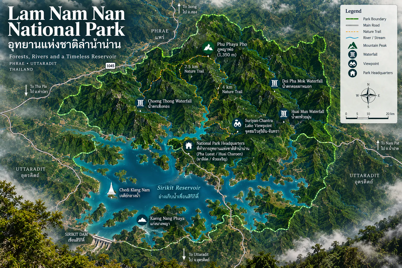
The main visitor base is in Pha Lueat Subdistrict, Tha Pla District. Headquarters sits north of Sirikit Dam, in the landscape above the reservoir. From Uttaradit, travellers generally approach the Tha Pla / Sirikit Dam area, then continue toward the park.
From Phrae
The park can also be approached from the Phrae side, particularly toward the Choeng Thong / Phu Phaya Pho landscape. This side is more strongly associated with mountain roads, forest and viewpoints.
By private car
A private car is the most practical option. The park is geographically spread out, and attractions are not concentrated into one compact visitor zone. A car lets you combine viewpoints, forest trails, waterfalls and the reservoir in the same trip.
Where to Stay
Inside the park
The park provides accommodation and camping areas. Government tourism information lists park houses and camping facilities. The provincial tourism authority lists two park houses and camping among the options, although individual availability should be confirmed before travel. For a nature-focused visit, staying overnight is preferable to treating Lam Nam Nan as a quick roadside stop.
Outside the park
- Best base for the reservoir
- Tha Pla / Sirikit Dam area.
- Best base for city comfort
- Uttaradit.
- Best base for the Phrae side
- Mueang Phrae.
How Long Do You Need?
- Half day
- Reservoir views, one viewpoint, a short stop. It only scratches the surface.
- One full day
- A good minimum: Sirikit Reservoir, viewpoints, one nature trail and one waterfall.
- 2 days / 1 night
- ThailandLover recommendation. The most balanced way to see water and forest without rushing.
- 3 days / 2 nights
- Best if you also want the more remote mountain landscapes toward Phu Phaya Pho.
A suggested ThailandLover escape
Two days and one night. The point is to experience the landscape, not to collect every attraction.
- Day 1 — Water & mountains
- Arrive in the Sirikit Dam / Lam Nam Nan area. Explore the reservoir in the late morning. Follow scenic routes and viewpoints in the afternoon. Head toward a reservoir viewpoint for changing light. Camp or stay overnight.
- Day 2 — Forest & waterfalls
- Sunrise over the reservoir. Walk the 2.5 km nature trail. Visit a nearby waterfall in the late morning. Continue toward another viewpoint or scenic route, then depart.
What Makes Lam Nam Nan Different?
Thailand has many famous national parks — spectacular peaks, enormous waterfalls, limestone cliffs, caves, beaches, cloud forests. Lam Nam Nan is different. Its strength is composition.
It brings together landscapes that are often experienced separately:
- Mountain forest
- Streams and waterfalls
- Rocky rapids
- Sirikit Reservoir
- Islands and mountain horizons
This is a park for travellers who enjoy landscape rather than individual attractions.
Who Should Visit?
- Nature lovers and landscape photographers
- Road-trip travellers and couples looking for quiet scenery
- Campers and birdwatchers
- Travellers interested in northern Thailand beyond the major tourist circuit
- Visitors who enjoy reservoirs, mountain landscapes and a slower national-park pace
- Photographers
- Mountain, water and changing light give the park real visual depth.
- Campers
- The reservoir and the cooler northern climate make a natural overnight setting.
- Slow travellers
- Lam Nam Nan rewards time rather than speed.
Who may not love it?
This may not be the right park if you are looking for a major waterfall with spectacular vertical drops, highly developed tourist infrastructure, cafés and restaurants inside the park, easy access to every attraction, a dense cluster of iconic photo spots, or an adventure park with organised activities everywhere.
This is a landscape destination. Its appeal is quieter.
Responsible Travel
Lam Nam Nan is a watershed landscape. That matters. The forests around the reservoir are not simply scenery. They regulate water, support wildlife and protect mountain ecosystems.
- Carry out all rubbish, and avoid single-use plastic where you can
- Stay on designated trails and use designated camping areas
- Never feed wildlife, and never approach wild animals
- Keep noise low
- Do not collect plants, rocks or other natural materials
- Respect fire restrictions and follow park officers
- Do not enter water when conditions are unsafe
- Check local conditions before remote mountain routes
The best souvenir from Lam Nam Nan is the landscape exactly as you found it.
Important Safety Notes
The park combines mountains and a large reservoir. Conditions can change quickly.
- Around water
- Never assume that calm-looking water is safe. Follow local instructions on boating, swimming, water levels, weather and storms.
- During rain
- Heavy rainfall can raise stream and waterfall flow quickly. Do not enter streams or rocky rapids when levels rise.
- On mountain roads
- Remote roads may be steep, narrow or uneven. Drive slowly. Do not head into unfamiliar mountain routes after dark.
- In the cool season
- Higher elevations and early mornings can be significantly cooler. Bring an extra layer if you are camping.
Entrance Fees & Facilities
Tourism Authority of Thailand information currently lists the following admission rates. Fees, exemptions, camping charges, accommodation charges and operating conditions can change. Always verify current rates and opening conditions with the park before travelling.
- Thai visitors
- Adult 20 THB · Child 10 THB
- Foreign visitors
- Adult 100 THB · Child 50 THB
Depending on current operating conditions, facilities include park headquarters, accommodation, camping areas, nature trails, scenic viewpoints, visitor information and access to reservoir activities.
Best Photography Moments
- Sunrise
- Reservoir and mountain silhouettes can make excellent early-morning compositions.
- Sunset
- Open water and layered ridges give strong sunset framing.
- After rain
- Wet forest, waterfalls and atmospheric mountains can be particularly photogenic.
- Dry season
- Clearer visibility can open stronger long-distance mountain views.
ThailandLover Rating
An editorial assessment of the destination experience, not an official government rating. Lam Nam Nan scores particularly highly for landscape composition, reservoir scenery and quiet nature, rather than for large-scale adventure attractions.
- Landscape
- Forest, ridges and water in one composition.
- Mountain views
- Phu Phaya Pho and the viewpoint roads.
- Reservoir scenery
- The park’s defining landscape.
- Photography
- Stay for low light.
- Nature experience
- Quiet, and better for it.
- Wildlife potential
- Habitat, not a guaranteed sighting.
- Hiking
- Short study trails, not a long expedition.
- Waterfalls
- Intimate forest falls, not vertical spectacle.
- Camping
- Strongest in the cooler months.
- Accessibility
- A car helps. Remote roads need a local check.
- Facilities
- Park houses, camping and headquarters — not a resort.
- Overall
- A landscape to move through slowly.
Essential Information
- Destination
- Lam Nam Nan National Park · อุทยานแห่งชาติลำน้ำน่าน
- Region
- Northern Thailand · Phrae & Uttaradit
- Published area
- 999.15 km² / 624,468 rai
- Highest point
- Phu Phaya Pho, 1,350 m
- Established
- 30 September 1998 · National Park No. 87
- Main landscape
- Mountain forest and Sirikit Reservoir
- Nature trails
- 2.5 km and 4 km
- Main attractions
- Sirikit Reservoir, Kaeng Nang Phaya, Ko Nom Sao, Suriyan–Chantra Lake Viewpoint, Choeng Thong, Huai Mun and Doi Pha Mok waterfalls, Phu Phaya Pho
- Accommodation
- Park houses and camping — confirm before travel
- Headquarters
- Pha Lueat Subdistrict, Tha Pla District, Uttaradit 53190
- Telephone
- +66 90 604 7793
Frequently Asked Questions
- What is Lam Nam Nan National Park?
- A landscape across Phrae and Uttaradit where forested mountains meet Sirikit Reservoir. It is about forest, water and mountain terrain together — viewpoints, short trails, rocky rapids and reservoir islands — not a single famous summit.
- How large is the park?
- The published area is 999.15 km² (624,468 rai). A minor adjustment of about 24.61 rai in Uttaradit was in public consultation in 2026. That is not a redefinition of the whole park.
- What is the highest point?
- Phu Phaya Pho, 1,350 metres, on the Phrae–Uttaradit boundary between Choeng Thong and Kiu Khian. Check road and weather conditions before going.
- When should I go?
- October to February is the strongest all-round season, including camping and trails. June to September is greener and wetter. The reservoir photographs well from October to May when the weather allows. Go early for birds and light.
- How do I get there?
- Headquarters is in Pha Lueat, Tha Pla, Uttaradit, north of Sirikit Dam. From Uttaradit, go via Tha Pla and the dam. From Phrae, the Choeng Thong and Phu Phaya Pho side is the natural approach. A car is the practical way to see more than one part of the park.
- What are the entrance fees?
- TAT lists 20 THB for Thai adults and 10 THB for Thai children, and 100 THB for foreign adults and 50 THB for foreign children. Confirm rates, camping and accommodation with the park on +66 90 604 7793.
- How long do I need?
- A half day is only a glimpse. One full day is a fair minimum. ThailandLover recommends two days and one night. Add a third day if Phu Phaya Pho is the point of the trip.
More of Phrae & Uttaradit
- Doi Pha Klong National Park
- A more compact Phrae landscape — stone, caves and the Yom — a useful contrast with Lam Nam Nan’s reservoir and ridges.
- Mae Yom National Park
- Further along the Yom watershed that Lam Nam Nan’s Phrae forests also feed.
- Wiang Kosai National Park
- Another forested park on the Phrae–Lampang side of northern Thailand.
- Phu Soi Dao National Park
- Uttaradit’s high mountain country — a different scale of northern peak from Phu Phaya Pho.
Location
Find Lam Nam Nan National Park
Pha Lueat, Tha Pla, Uttaradit 53190 · north of Sirikit Dam