



National Park · Phrae & Lampang
Wiang Kosai National Park
อุทยานแห่งชาติเวียงโกศัย
Where Mountain Forests Meet Cascading Waterfalls
Wang Chin · Long · Thoen · Northern Thailand
Waterfalls · Forest mountains · Hot springs · Nature trails — a quieter protected landscape between Phrae and Lampang.
The Quiet Side of Phrae
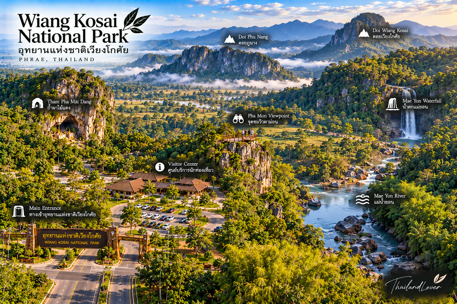
Tucked between the mountains of Phrae and Lampang, Wiang Kosai National Park (อุทยานแห่งชาติเวียงโกศัย) is one of Northern Thailand’s quieter protected landscapes.
It is best known for Mae Koeng Luang Waterfall, a seven-tiered cascade descending through steep forested mountain country. But the park offers more than a waterfall. Its forests protect headwaters, wildlife habitat, natural hot springs, mountain trails, old-growth trees and streams flowing toward the Yom River.
For travellers who prefer nature, quiet landscapes and authentic northern Thailand over crowded attractions, Wiang Kosai offers a slower way to experience the region.
Where mountain forests meet cascading waterfalls, hot springs, and the quiet landscapes of Phrae.
At a Glance
- 35th
- National park of Thailand. Established 9 October 1981 — the first in Phrae.
- ~410 km²
- Approximately 256,250 rai of mountain forest across Phrae and Lampang.
- Seven tiers
- Mae Koeng Luang — the signature staircase waterfall near headquarters.
- Check August–September
- Seasonal closure for flash floods and landslides. Confirm before you travel.
- Official Name
- Wiang Kosai National Park
- Thai Name
- อุทยานแห่งชาติเวียงโกศัย
- Province
- Phrae, with parts extending into Lampang
- Districts
- Long & Wang Chin, Phrae · Thoen, Sop Prap & Mae Tha, Lampang
- National Park No.
- 35
- Established
- 9 October 1981
- Area
- Approximately 256,250 rai / 410 km²
- Highest Elevation
- Approximately 1,267 m above sea level
- Landscape
- Mountain ranges, steep valleys, waterfalls and forested headwaters
- Main Forest Types
- Dry evergreen forest and mixed deciduous forest
- Signature Attraction
- Mae Koeng Luang & Mae Koeng Noi Waterfalls
- Other Highlights
- Mae Jork Hot Spring, Mon Mae Koeng, nature trails, ancient Takian trees
- Best Known For
- Waterfalls, forest scenery and peaceful northern mountain landscapes
The name “Wiang Kosai” refers to an old name associated with Phrae. The park was the first national park established in the province.
A Forest Between Two Provinces
Phrae · Lampang · watershed mountains
One of the interesting characteristics of Wiang Kosai is its geographical reach. The national park covers mountainous forest in both Phrae and Lampang, forming part of the larger forest landscape of northern Thailand.
The terrain is dominated by sandstone mountains, steep slopes, valleys and streams. Average elevation is around 800 metres, while the highest point reaches approximately 1,267 metres above sea level.
These mountains are more than scenery. They function as important watersheds. Streams originating in the park include Mae Koeng, Mae Jork, Mae Sin and Mae Pak. These waterways eventually form tributaries of the Yom River, connecting the mountain forest with the wider river system of northern Thailand.
This is one reason Wiang Kosai feels so green and alive around its valleys and waterfalls.
Mae Koeng Luang Waterfall
น้ำตกแม่เกิ๋งหลวง · the signature landscape
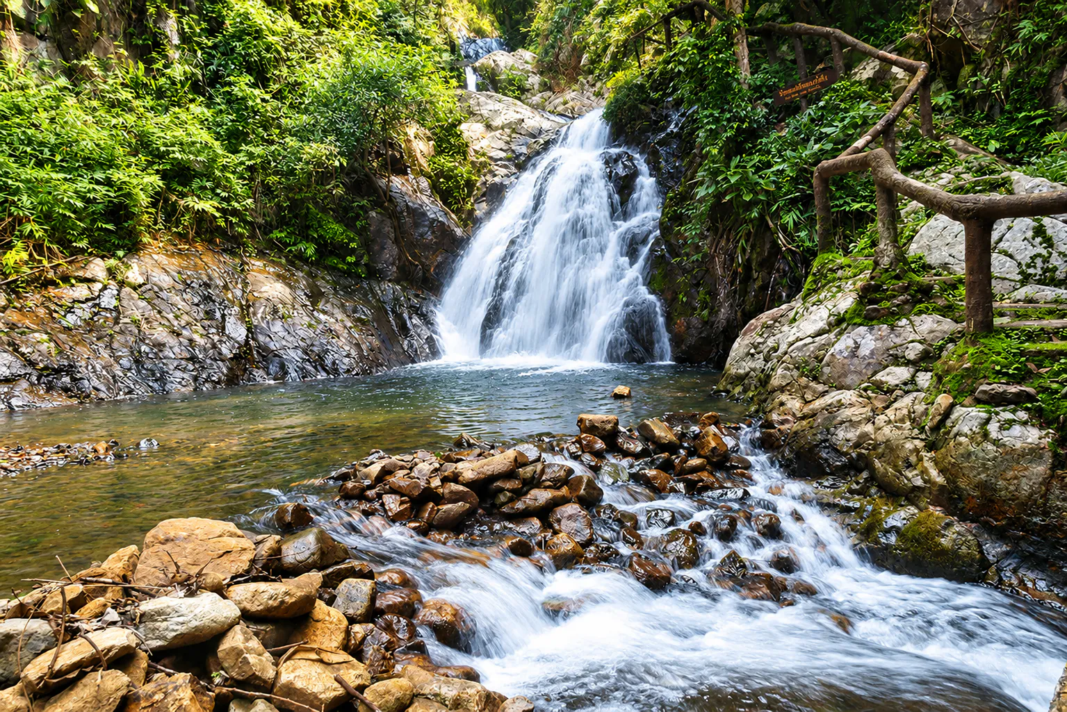
If there is one image that defines Wiang Kosai, it is Mae Koeng Luang Waterfall.
The waterfall descends through seven natural tiers, creating the appearance of a giant staircase carved into the forested mountainside. The local name is particularly appropriate — “Mae Koeng” is associated with the idea of a staircase, reflecting the waterfall’s stepped formation.
The seven levels descend for roughly 213 metres, framed by dense forest and steep mountain terrain. The lower area is close to park headquarters, making it one of the park’s most accessible natural attractions.
During suitable water conditions, some pools can offer opportunities to enjoy the water. Conditions can change rapidly, especially in the rainy season — always follow current instructions from park officials.
Forest → rock → water → mountain.
That combination is what makes Wiang Kosai distinctly northern.
Mae Koeng Noi Waterfall
น้ำตกแม่เกิ๋งน้อย · a walk into the same landscape
Beyond Mae Koeng Luang is Mae Koeng Noi Waterfall, another cascade within the same natural landscape.
Mae Koeng Noi is less immediately accessible than the main waterfall and requires walking from headquarters. The Tourism Ministry’s national attraction directory records the walking distance at approximately 2 kilometres.
Together, Mae Koeng Luang and Mae Koeng Noi form the central waterfall landscape of Wiang Kosai — better experienced on foot than as a quick photo stop.
Mon Mae Koeng
ม่อนแม่เกิ๋ง · a different view of waterfall country
Wiang Kosai is not only about looking at waterfalls from below. The park also has mountain viewpoints, including Mon Mae Koeng, where the landscape opens toward surrounding forest and mountain ranges.
The viewpoint becomes particularly atmospheric during the cooler months, when northern Thailand’s mountain landscapes can take on a softer, mistier character.
This is the side of Phrae that many travellers pass without seeing — quiet ridgelines, forest valleys and mountains stretching beyond the main roads.
Mae Jork Hot Spring
น้ำพุร้อนแม่จ๊อก · geothermal heat in the forest
Another distinctive attraction is Mae Jork Hot Spring, located approximately 5 kilometres from park headquarters and recorded at around 80°C.
That temperature is extremely hot. Treat the spring as a natural geothermal feature rather than an ordinary bathing pool.
The attraction is interesting because it reveals another side of the park’s geology and hydrology. Wiang Kosai is a landscape where water appears in several forms:
- Cool mountain streams
- Waterfalls
- Naturally heated groundwater
More Waterfalls to Discover
Mae Koeng is only the best-known waterfall system. Official park information also lists other water features, including:
- Mae Phung Luang Waterfall
- Mae Rang Waterfall
- Mae Sin Waterfall
- Huai O Waterfall
- Pan Jen Waterfall
- Mae Jork area
- Mae Pak and other mountain streams
The Takian Forest
ดงตะเคียน · ancient trees in a living forest
One of the quieter highlights of Wiang Kosai is its Takian forest, listed by the Department of National Parks as a natural attraction. Takian trees are important hardwoods of Thailand’s forests and can grow into large, impressive specimens.
Official tourism information specifically identifies an area known as Dong Takian, associated with large, old Takian trees.
For travellers interested in forest ecology, this is a reminder that Wiang Kosai is not simply a collection of waterfalls — its real value lies in the forest ecosystem surrounding them.
Giant Vines & Forest Trails
The park also lists Giant Vine and a nature study trail among its official attractions — particularly suitable for visitors who want to understand the forest rather than simply photograph it.
A nature trail lets you slow down and notice details that are easy to miss from a vehicle:
- Forest structure
- Vines and climbing plants
- Bamboo, palms and rattan
- Orchids and ground plants
- Streams and small waterways
- Signs of wildlife
Less about ticking off attractions. More about reading the landscape.
Forests of Wiang Kosai
Dry evergreen above · mixed deciduous below
Vegetation changes with elevation and terrain. Upper mountain areas are primarily associated with dry evergreen forest, while lower areas contain mixed deciduous forest.
Important tree species recorded by the Department of National Parks include:
- Afzelia xylocarpa
- Dipterocarp species
- Lagerstroemia species
- Pterocarpus macrocarpus
- Xylia xylocarpa
- Teak, bamboo, palms and rattan
Dry-season deciduous landscapes at lower elevations gradually give way to greener forest environments higher in the mountains — the characteristic northern mountain appearance of Wiang Kosai.
Wildlife
Wiang Kosai provides habitat for a variety of forest wildlife. Official information records species such as:
- Wild boar
- Muntjac
- Squirrels
- Tree shrews
- Various bird species
Historical records also mention larger animals, including wild elephants, tigers and sambar deer, but the park’s current official profile emphasises the smaller mammals and birdlife commonly associated with its forest and water environments.
A Small Orchid With a Short Season
Wiang Kosai Lin Mangkon · Pat Daeng · Sang Hin
The park has highlighted a small terrestrial orchid locally known as Wiang Kosai Lin Mangkon, also called Pat Daeng or Sang Hin.
It grows around rocks and is reported to flower only once a year, generally around September to November.
Rather than a large, dramatic attraction, this orchid rewards visitors who pay attention to the forest floor — a seasonal detail that is easy to overlook.
The Seasons of Wiang Kosai
- March – May · Hot season
- Temperatures can become high, particularly around April. Forest areas may feel considerably warmer than the cooler mountain season.
- June – October · Rainy season
- The landscape becomes greener and waterfalls can become more dramatic. Mountain streams can also rise rapidly and slopes may become unstable.
- November – February · Cool season
- Generally the most comfortable period for exploring the mountain environment. Official climate information records temperatures dropping to about 13°C in December, while April can reach around 39°C.
When Should You Visit?
For a classic Wiang Kosai experience, the cool season from November to February offers comfortable conditions for walking, sightseeing and time outdoors.
The period immediately after the rainy season can also bring attractive green landscapes and stronger waterfalls — check local conditions carefully.
Camping & Staying Overnight
Stay inside the forest if you can
Wiang Kosai is equipped for visitors who want to stay within the national park. The current DNP reservation system lists:
- Accommodation
- Wiang Kosai 102 — Mae Jork · Wiang Kosai 103 — Mae Koeng Noi
- Camping
- Wiang Kosai Camping Area · Youth Camp Camping Area
- Tents
- Three-person tents listed in both camping zones
Availability depends on the park’s operating schedule and reservation system. Check official DNP booking information before making plans.
How to Experience Wiang Kosai
Wiang Kosai works particularly well for travellers who enjoy combining several small experiences rather than rushing through a checklist.
- A simple visit
- Mae Koeng Luang → Nature Trail → Forest → Viewpoint — ideal for a short nature visit.
- A slower day
- Mae Koeng Luang → Mae Koeng Noi → Mae Jork Hot Spring → Forest exploration — better if you want more time inside the park.
- An overnight experience
- Waterfall → Nature Trail → Sunset / mountain atmosphere → Camping — lets the forest become the main experience, not only the background to a waterfall stop.
Getting There
Phrae → Wang Chin → Mae Koeng
The main visitor area around Mae Koeng is accessed from Phrae toward Wang Chin. The park connects to the regional road network via Highway 1023, the Phrae–Wang Chin route.
Official DNP information identifies the main visitor area around Mae Koeng in Wang Chin District, Phrae Province.
- Practical approach
- Reach Phrae first, then continue by road toward Wang Chin and the national park.
- Best transport
- A private car or hired vehicle is the most flexible option — attractions are distributed across a large mountainous area.
A Landscape Built Around Water
The most interesting way to understand Wiang Kosai is to follow its water.
Rain falls on the mountains. The forest absorbs and releases it. Streams form in the valleys. Water descends over sandstone. Waterfalls appear. Some water emerges from the ground as hot springs. And eventually these streams become part of the river system flowing toward the Yom River.
That makes the park more than a scenic destination.
It is a watershed landscape.
Why Wiang Kosai Feels Different
Wiang Kosai does not have the international profile of Thailand’s most famous national parks. And that is part of its character.
There are no enormous limestone cliffs dominating the horizon. No famous beach. No major resort town inside the park. Instead, the experience is built from smaller details:
- A seven-level waterfall
- A forest trail
- A hot spring
- Old trees
- Mountain streams
- Quiet valleys
- The changing light of Northern Thailand
It is a place where the landscape becomes more interesting the longer you stay.
Responsible Travel
Wiang Kosai is a protected watershed and forest ecosystem. Visitors can help protect it by following a few simple principles:
- Stay on designated trails and visitor areas
- Follow temporary closures and warning signs
- Do not enter waterfalls or streams when conditions are unsafe
- Never leave plastic, food waste or other rubbish behind
- Do not collect plants, rocks, flowers or forest products
- Keep noise levels low
- Do not feed wildlife
- Avoid disturbing birds and other animals
- Do not enter restricted forest areas without authorisation
- Respect local communities and park staff
Essential Information
- Park
- Wiang Kosai National Park · อุทยานแห่งชาติเวียงโกศัย
- Location
- Wang Chin District, Phrae, Thailand
- Area
- Approximately 256,250 rai / 410 km²
- Established
- 9 October 1981
- National Park Number
- 35
- Highest Point
- Approximately 1,267 metres above sea level
- Main Attraction
- Mae Koeng Luang & Mae Koeng Noi Waterfalls
- Other Attractions
- Mae Jork Hot Spring, Mae Phung Luang, Mae Rang, Mae Sin, Huai O, Pan Jen, Dong Takian, Giant Vine and nature trails
- Park Contact
- +66 81 030 8663
- 2026 seasonal closure
- 1 August – 30 September 2026
- Scheduled reopening
- 1 October 2026
- Official information
- Department of National Parks, Wildlife and Plant Conservation
Frequently Asked Questions
- What is Wiang Kosai National Park?
- A mountain-forest national park across Phrae and Lampang — best known for Mae Koeng Luang’s seven-tier waterfall, Mae Koeng Noi, Mae Jork Hot Spring, forest trails and quiet watershed landscapes feeding the Yom River.
- Where is it?
- Main visitor area around Mae Koeng in Wang Chin District, Phrae. Park forest also reaches Long (Phrae) and Thoen, Sop Prap and Mae Tha (Lampang). Access via Highway 1023 on the Phrae–Wang Chin route.
- When is the best time to visit?
- November–February for cooler walking weather. Post-rain landscapes can be lush, but streams rise quickly. Confirm seasonal closures — for 2026, tourism closure was announced 1 August–30 September.
- Can I camp overnight?
- Yes — DNP lists lodging at Mae Jork and Mae Koeng Noi, plus camping areas and tent rental. Check the official reservation system and operating schedule first.
- What should I not miss?
- Mae Koeng Luang, Mae Koeng Noi, Mae Jork Hot Spring, Mon Mae Koeng, the nature trail and Dong Takian’s old Takian trees.
More of the Yom Country
- Mae Yom National Park
- Natural teak forest and Kaeng Suea Ten on the Yom River between Phrae and Lampang.
- Doi Pha Klong National Park
- Mountain streams that also feed the wider Yom system in Phrae.
- Lam Nam Nan National Park
- Reservoir shores and mountain forest linking Nan and Uttaradit.
- Si Nan National Park
- Southern Nan’s mountain-and-river landscape — Doi Samer Dao, cliffs and dark skies.

Location
Find Wiang Kosai National Park
Wang Chin District, Phrae · main visitor area around Mae Koeng · park forest continues into Lampang