



National Park · Phitsanulok · Phetchabun
Thung Salaeng Luang National Park
อุทยานแห่งชาติทุ่งแสลงหลวง
Thai Savanna · Pine Forests · Mountain Grasslands · Waterfalls · Wildlife
Phitsanulok · Phetchabun · Northern Thailand
Where dense forest opens into sweeping grassland, pine woodland and misty mountain valleys — one of Thailand’s most distinctive protected landscapes.
The Open Side of Thailand’s Wild North
There is a part of northern Thailand where the landscape suddenly opens.
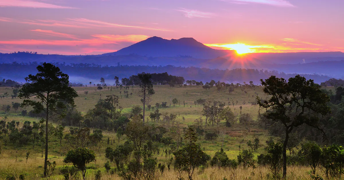
The dense forest gives way to sweeping grasslands. Pine trees rise above open woodland. Mist settles across the valley in the early morning, and wildflowers appear among the grasses after the rains.
This is Thung Salaeng Luang National Park (อุทยานแห่งชาติทุ่งแสลงหลวง).
Spreading across the mountains of Phitsanulok and Phetchabun, the park is one of Thailand’s most distinctive protected landscapes. Rather than being defined by a single waterfall or mountain peak, it is known for the remarkable relationship between forest, savanna-like grasslands, mountains and water.
Its signature landscapes include Thung Salaeng Luang, Thung Nang Phaya and Thung Noen Son, while waterfalls, caves, streams and pine forests reveal other sides of the park.
Walk into the grassland. Watch the mist move across the forest. Discover one of Thailand’s great open landscapes.
At a Glance
- No. 3
- Thailand’s third national park — established 29 January 1963.
- 1,262 km²
- Approximately 789,000 rai of protected mountain landscape.
- 1,028 m
- Khao Khae — the park’s highest point.
- Thai Savanna
- Open grassland meeting pine forest and mountain valleys.
- Nong Mae Na
- Gateway to the grasslands, pine woodland and slow nature routes.
- Official Name
- Thung Salaeng Luang National Park
- Thai Name
- อุทยานแห่งชาติทุ่งแสลงหลวง
- Provinces
- Phitsanulok and Phetchabun
- Districts
- Wang Thong, Nakhon Thai, Noen Maprang, Khao Kho and Wang Pong
- Established
- 29 January 1963
- National Park No.
- 3
- Official Area
- Approximately 789,000 rai / 1,262.40 km²
- Mountain Range
- Phetchabun Mountain Range
- Highest Point
- Khao Khae — approximately 1,028 m
- Main Landscape
- Grassland, savanna-like woodland, pine forest, evergreen forest, deciduous forest and mountains
- Famous For
- Thung Salaeng Luang, Thung Nang Phaya, Thung Noen Son and Kaeng Sopha Waterfall
- Best For
- Nature, photography, camping, hiking, wildflowers, wildlife and scenic landscapes
The park covers parts of five districts across Phitsanulok and Phetchabun. The Department of National Parks currently lists approximately 789,000 rai (1,262.40 km²).
Why Thung Salaeng Luang Is Special
Thailand has many spectacular forests. Thung Salaeng Luang is different because of its open landscapes.
Large areas of grassland interrupt the surrounding forest, creating a landscape that feels almost like a natural savanna. The result is a sequence of contrasting environments:
- Dense Forest
- Pine Woodland
- Open Grassland
- Mountain Valley
- Waterfall
The park’s official description calls it “the savanna of Thailand’s forest.” This open character is particularly striking in the early morning, when mist floats above the grass and the surrounding hills emerge gradually through the haze.
The Story Behind the Name
The name Thung Salaeng Luang comes from the large grassland known as Thung Salaeng Luang in the southern part of the park.
The Department of National Parks explains that the name is believed to be connected with Salaeng Jai, a large tree whose ripe fruits have an orange-red color and whose seeds contain strychnine.
The landscape was historically characterized by rolling terrain, different forest types and abundant wildlife. The name therefore reflects both the landscape and the vegetation historically associated with the area.
The important point for visitors is that the name is not simply a poetic description — it is rooted in the ecological character of the landscape.
A National Park with a Long History
The conservation history of Thung Salaeng Luang goes back to the early development of Thailand’s national-park system.
On 7 October 1959, the Cabinet approved the principle of establishing several forest areas as national parks, including Thung Salaeng Luang. Surveys followed in 1960.
The area was subsequently officially declared a national park through a Royal Decree published in the Royal Gazette on 29 January 1963. This made Thung Salaeng Luang Thailand’s third national park.
The park’s boundaries were later adjusted. In 1972, part of the original area was withdrawn and the national-park boundary was redefined. A further legal adjustment followed in 1975. The currently published park area is approximately 789,000 rai.
The Phetchabun Mountains
Sandstone plateaus · valleys · open uplands
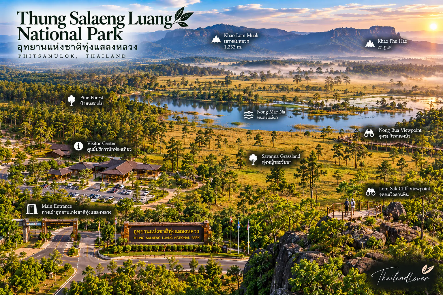
Thung Salaeng Luang lies within the Phetchabun Mountain Range, which generally runs from north to south and forms an important geographical divide between Phitsanulok and Phetchabun.
The average elevation of the park is approximately 500 metres above sea level. Its highest point is Khao Khae, reaching approximately 1,028 metres.
The underlying geology is dominated by sandstone. This helps explain the shape of the landscape: broad or relatively flat mountain tops contrast with deeply incised valleys and steep slopes where erosion has cut into the sandstone.
The park does not simply rise into sharp alpine peaks. Instead, it creates layered mountain plateaus, valleys, cliffs and open uplands.
A Major Watershed
The mountains of Thung Salaeng Luang are also important as a source of water. Streams originating in the park include:
- Huai Khek Yai
- Huai Khek Noi
- Lam Nam Thum
- Khlong Chomphu
- Khlong Nam Poi
- Khlong Wang Thong
- Huai Kok
These waterways connect the mountain forests with larger river systems and surrounding communities. The park is therefore important not only for tourism but also for watershed protection and regional water security.
The grasslands may be the visual highlight. The forest is the infrastructure beneath them.
Thung Salaeng Luang
The great grassland · approximately 10 km²
The park’s namesake landscape is one of its most recognizable scenes. Thung Salaeng Luang is a broad grassland landscape of approximately 10 km², located in the southern part of the national park around the Nong Mae Na area.
The grassland is surrounded by dry dipterocarp woodland, creating an unusual transition between open meadow and forest. Mountains form the backdrop, giving the landscape a strong sense of scale.
In the early morning, mist can settle above the grass. During the dry season, the deciduous forest changes color as leaves turn yellow and reddish tones spread across the landscape. During the rainy season, the grassland becomes greener and small wildflowers appear.
The scenery changes dramatically throughout the year.
The Flowers of Thung Salaeng Luang
One of the park’s seasonal pleasures is its wildflower display. During the rainy season, small flowers emerge among the grass. The Department of National Parks specifically highlights species such as:
- Soi Suwan-na
- Dusita
- Jok Bawai
These flowers can create small patches of color across the open grassland. They are delicate rather than spectacular in the conventional sense. The beauty comes from seeing them spread naturally through the enormous landscape.
Visitors should avoid walking directly through flower patches. The grassland is an ecosystem, not a garden.
Thung Nang Phaya
ทุ่งนางพญา · open grass, isolated trees, mountain backdrop
Another important open landscape is Thung Nang Phaya. Like Thung Salaeng Luang, it combines grassland and woodland, creating a broad natural clearing within the mountain forest.
The landscape is particularly atmospheric when morning mist settles between the grass and trees. For photographers, Thung Nang Phaya offers a different composition from the more expansive Thung Salaeng Luang:
Open grass + isolated trees + mountain backdrop
The best photographs often come from the subtle interaction between light, mist and vegetation rather than from a single landmark.
Thung Noen Son
ทุ่งเนินสน · pine forest and highland grassland
Thung Noen Son is one of the park’s most distinctive highland environments. The landscape combines open grassland with two-needle pine trees, creating a cool, spacious atmosphere.
Unlike the dense evergreen forests found elsewhere in Thailand, the pine woodland allows considerable light to reach the forest floor. Grasses, ferns and seasonal plants grow between the trees.
The area is particularly attractive for travelers interested in:
- Landscape photography
- Camping
- Nature walks
- Seasonal wildflowers
- Quiet forest environments
Access to some areas can be seasonal or subject to park regulations, so visitors should check current conditions before planning a visit.
Kaeng Sopha Waterfall
น้ำตกแก่งโสภา · the great waterfall of the Khek River
Kaeng Sopha Waterfall is one of the major natural attractions associated with Thung Salaeng Luang National Park. The waterfall lies along the Khek River and forms a series of powerful cascades flowing through a rocky gorge.
Its appearance changes significantly with rainfall. During wetter periods, the river becomes much stronger and the waterfall can appear dramatic. During drier conditions, exposed rocks become more visible and the character of the falls changes.
The waterfall is one of the clearest examples of how the park’s sandstone geology interacts with flowing water.
Son Som Waterfall
Son Som Waterfall is another waterfall within the park. It is located in a forested environment and provides a quieter contrast to the larger Kaeng Sopha area.
The surrounding vegetation gives the waterfall a more intimate character. As with many waterfalls in mountain parks, water volume depends strongly on rainfall. A visit during the wet season can produce a completely different experience from a visit during the dry season.
Wang Nam Yen Rapids
Kaeng Wang Nam Yen is a scenic rapids area associated with the park’s waterways. Rather than a single vertical waterfall, the landscape here is shaped by fast-moving water passing through rocky channels.
The site demonstrates another side of the park’s hydrology. The same mountains that create open grasslands and forests also generate streams and rapids that eventually feed larger river systems.
Caves of Thung Salaeng Luang
The park’s sandstone and limestone-related landscapes also contain caves. The Department of National Parks lists several cave attractions, including:
- Bat Cave
- Tham Duean–Tham Dao
- Phra Wang Daeng Cave
These are different types of natural environments from the open grasslands. Visitors should not assume that every cave is freely accessible year-round. Caves are sensitive environments, and access may depend on safety, conservation, weather and local management conditions.
Phra Wang Daeng Cave
Phra Wang Daeng Cave is among the best-known cave systems associated with Thung Salaeng Luang. The cave is part of the park’s extensive underground landscape and is known for its large-scale passages and geological formations.
The cave environment is significantly different from the open grasslands above. Darkness, humidity, water and limestone formations create specialized habitats for cave organisms, including bats.
Cave exploration should only be undertaken under appropriate supervision and according to current park regulations.
The Forests of Thung Salaeng Luang
One of the park’s greatest strengths is its forest diversity. The Department of National Parks identifies seven major vegetation communities.
1. Hill Evergreen Forest
Found at elevations of approximately 1,000 metres and above. Typical plants include wild mango relatives, oaks, stone oaks, mountain forest species and two-needle pine. The understory contains mosses, ferns, vines, rattan and various herbs.
2. Moist Evergreen Forest
Found at approximately 800 metres and above, especially along moist valleys and slopes. The forest supports a dense mixture of trees, vines and epiphytes. Mosses and ferns are particularly common in damp environments.
3. Dry Evergreen Forest
Dry evergreen forest occurs across areas from approximately 500 metres upward. The canopy remains relatively dense but experiences a stronger seasonal influence than moist evergreen forest.
4. Pine Forest
One of the park’s signature forest types. The pine forest occurs around 700–900 metres and often forms a mosaic with grassland. Two-needle pine is particularly characteristic. The combination of pine trees and open grass is one of the landscapes most strongly associated with Thung Salaeng Luang.
5. Mixed Deciduous Forest
Found around 400–700 metres. Trees include rosewood, padauk, Lagerstroemia, Afzelia, Siamese rosewood and various deciduous species. Bamboo and seasonal understory plants are common.
6. Dry Dipterocarp Forest
This forest type occurs at lower elevations, around 400 metres. Trees include dipterocarps, teng, rangs, phluang and wild mango. During the dry season, the forest becomes more open and leaf fall creates a distinctive golden-brown landscape.
7. Grassland
The grasslands are among the park’s defining landscapes. They contain numerous grass species, together with scattered small trees and seasonal flowering plants. These grasslands are not simply areas where forest failed to grow — they are a distinctive ecological community shaped by environmental conditions and historical land management.
Wildlife
Thung Salaeng Luang supports a wide range of wildlife across its different forest habitats. The Department of National Parks records species including:
- Asian elephant, gaur, sambar deer and wild boar
- Northern pig-tailed macaque and northern leaf monkey
- Hare, common palm civet, squirrels and bats
- Numerous birds, reptiles, amphibians and freshwater fish
Birdlife includes green pigeons, Asian palm swift, blue-winged pitta, common myna, white-crested laughingthrush, flycatchers, drongos and other forest and grassland birds.
Wildlife sightings are never guaranteed. The park is a natural habitat, not a wildlife enclosure. Observe quietly and give animals plenty of space.
A Landscape for Birdwatchers
The combination of forest, pine woodland and open grassland creates a particularly interesting environment for birdwatching. Different habitats support different species.
- Forest birds occupy the canopy
- Grassland species use open areas
- Streams and wetlands attract birds associated with water
For serious birdwatchers, the park is therefore more interesting than a single viewpoint might suggest. Bring binoculars, move slowly and listen. Often the first sign of a bird is its call rather than its appearance.
The Changing Seasons
Rainy Season · May–October
The forest becomes lush and the streams carry more water. Grasslands turn green. Wildflowers appear across open areas. The park can be particularly atmospheric under mist and low clouds. September generally receives the greatest rainfall.
Cool Season · November–February
This is the cooler period and one of the most comfortable times for outdoor exploration. Mornings can be cold, particularly at higher elevations. Mist over the grasslands is one of the season’s most beautiful scenes.
Hot Season · March–June
Temperatures increase, with the DNP recording maximum temperatures around 29°C. The dry landscape becomes more prominent. In dry dipterocarp forests, trees shed their leaves and the landscape can turn yellow, orange and reddish brown.
Best Time to Visit
The best season depends on what you want to see.
- Morning mist
- November–February — cool mornings provide some of the park’s most atmospheric conditions.
- Green grasslands
- Rainy season — the landscape becomes lush and wildflowers appear.
- Wildflowers
- Rainy season into the transition toward the cool season. Flowering depends on rainfall and local conditions.
- Hiking
- Cool season — lower temperatures make long walks more comfortable.
- Waterfalls
- Rainy season — water levels are generally stronger, although heavy rain can affect access and safety.
Nong Mae Na
หนองแม่นา · the gateway to the open landscape
The Nong Mae Na area in Phetchabun is one of the most important visitor areas for experiencing the park’s grasslands. It provides access to landscapes including:
- Thung Salaeng Luang
- Thung Nang Phaya
- Thung Noen Son
- Kaeng Wang Nam Yen
The Tourism Authority of Thailand identifies Nong Mae Na as one of the main access points and notes a 3-kilometre nature study route beginning at the Nong Mae Na office.
For travelers who want to experience the park without undertaking a demanding multi-day trek, this area is particularly useful.
Nature Study Trail
The Pho Ko Rice Field Nature Study Route is a short nature-study route associated with the Nong Mae Na area. The trail is approximately 3 kilometres.
It provides an accessible introduction to the park’s natural environment. Rather than focusing on one attraction, the route allows visitors to observe vegetation, grassland and forest interactions at a slower pace.
Cycling and Slow Exploration
Some areas of the park can be explored by bicycle or vehicle depending on current park regulations and road conditions. The open landscapes around Nong Mae Na are particularly suited to slow travel.
The landscape is not designed to be rushed. A forest road, a patch of pine woodland and a grassland vista can change dramatically with the time of day.
For ThailandLover travelers, this is a destination where the journey between attractions is part of the attraction.
Camping
Camping is one of the best ways to experience Thung Salaeng Luang. The DNP currently lists visitor accommodation and camping facilities in several zones.
The Nong Mae Na area, approximately 60 km from the main park office, provides accommodation, tents and a camping area. The park also has camping facilities around the sling bridge / Khek River area.
The Tourism Authority of Thailand also lists tent rental and camping facilities in the Nong Mae Na area. For current availability, visitors should use the official DNP reservation system.
How to Get There
Because Thung Salaeng Luang covers a very large area, the best route depends on which part of the park you want to visit.
To Nong Mae Na
A common approach is from Phetchabun / Khao Kho. Travelers follow the road toward Khao Kho and continue toward Nong Mae Na. The Tourism Authority of Thailand describes access from Phetchabun via Highway 21 before continuing toward Khao Kho and the Nong Mae Na area.
From Phitsanulok
Travelers can approach from the Phitsanulok–Lom Sak route via Highway 12. This is useful for visitors exploring the northern and central sections of the park. The Tourism Authority of Thailand identifies Highway 12 as one of the principal approaches from Phitsanulok.
Driving in the Park
Thung Salaeng Luang is large. Do not assume that attractions shown on a map are close together. Some visitor areas are separated by many kilometres of forest road.
For remote attractions, road conditions can vary with the season. During rainy periods, unpaved or forest roads may become muddy. Before driving to a remote location:
- Check current road conditions
- Ask park staff about access
- Check whether four-wheel drive is required
- Allow extra travel time
- Avoid remote roads after dark unless permitted and necessary
What to Bring
- A day visit
- Comfortable walking shoes, drinking water, sun protection, insect repellent, a light rain jacket, camera, binoculars and a small first-aid kit.
- Camping
- Warm clothing, headlamp, personal medication, waterproof bags, sleeping equipment where required and sufficient drinking water.
Temperatures can drop considerably at night, especially during the cool season.
Responsible Travel
The open grasslands can look resilient. They are not. Grassland plants and seasonal flowers are part of a living ecosystem.
- Stay on paths
- Use designated trails and roads only.
- Protect wildflowers
- Do not pick flowers or walk through flower patches.
- Respect wildlife
- Do not feed animals or disturb birds.
- Leave no trace
- Do not leave food or plastic waste behind.
- Protect caves
- Do not enter caves without permission or appropriate guidance.
- Protect streams
- Do not use soap or chemicals in streams.
A photograph is enough. The landscape should remain intact for the next visitor.
Thung Salaeng Luang and Khao Kho
The park is often visited together with Khao Kho, but they are not the same destination.
Khao Kho is a broader mountain tourism area with resorts, viewpoints and agricultural landscapes. Thung Salaeng Luang is a protected national-park landscape.
The two can work well together in an itinerary:
Khao Kho → Nong Mae Na → Thung Salaeng Luang → Waterfalls → Forest
This allows travelers to experience both the developed mountain destination and the protected forest landscape.
A Different Side of Northern Thailand
Thung Salaeng Luang does not look like the stereotypical image of northern Thailand. There are no towering limestone cliffs like Krabi. No dramatic rice terraces dominate the scenery.
Instead, there are wide grasslands, pine trees, sandstone mountains and mist drifting across open country. It feels spacious. Quiet. Almost unexpected.
And that is precisely why it belongs on a Thailand nature itinerary.
Why Visit Thung Salaeng Luang?
Because it offers something relatively rare in Thailand: space.
A place where you can look across a grassland rather than through a forest. Where a pine tree can stand alone against the sky. Where mist moves slowly through a valley. Where wildflowers appear naturally after the rains. And where an enormous protected forest continues beyond the horizon.
Thung Salaeng Luang is not about one spectacular attraction. It is about the relationship between all of them — forest, grassland, mountain, water and wildlife.
ThailandLover Travel Guide
- Best for
- Nature lovers, photographers, campers, hikers, birdwatchers, wildlife enthusiasts and slow travellers
- Travel style
- Nature, wildlife, landscape and camping
- Don’t miss
- Thung Salaeng Luang, Thung Nang Phaya, Thung Noen Son, Kaeng Sopha Waterfall, Kaeng Wang Nam Yen and Nong Mae Na
- Best experience
- Spend a night near Nong Mae Na and explore the grasslands around sunrise, when mist and soft light transform the landscape
- Travel character
- Open, peaceful, wild, misty and expansive
Essential Information
- Park
- Thung Salaeng Luang National Park · อุทยานแห่งชาติทุ่งแสลงหลวง
- Location
- Phitsanulok · Phetchabun, Thailand
- Established
- 29 January 1963 · National Park No. 3
- Official DNP area
- Approximately 789,000 rai / 1,262.40 km²
- Mountain range
- Phetchabun Mountain Range
- Highest point
- Khao Khae — approximately 1,028 metres
- Main landscape
- Grassland, pine forest, evergreen forest, deciduous forest, mountain forest and streams
- Signature landscapes
- Thung Salaeng Luang · Thung Nang Phaya · Thung Noen Son
- Main waterfall
- Kaeng Sopha Waterfall
- Other attractions
- Son Som Waterfall · Kaeng Wang Nam Yen · Bat Cave · Tham Duean–Tham Dao · Phra Wang Daeng Cave
- Main visitor areas
- Park Headquarters · Nong Mae Na · Khek River / sling-bridge area
- Park contact
- +66 55 268 019
+66 88 756 4940
Opening conditions, road access, camping availability, cave access and temporary closures can change according to weather, conservation requirements and park regulations. Check the Department of National Parks before travelling.
Frequently Asked Questions
- What is Thung Salaeng Luang National Park?
- Thailand’s third national park, known for open savanna-like grasslands, pine forests, mountain valleys and waterfalls across Phitsanulok and Phetchabun. Signature landscapes include Thung Salaeng Luang, Thung Nang Phaya and Thung Noen Son.
- Where is it, and how large is it?
- Five districts across Phitsanulok and Phetchabun: Wang Thong, Nakhon Thai, Noen Maprang, Khao Kho and Wang Pong. Established 29 January 1963. Official area: approximately 789,000 rai, or 1,262.40 km².
- When is the best time to visit?
- November–February for cool mornings and mist. Rainy season for green grass, wildflowers and stronger waterfalls. Cool season for comfortable hiking.
- What should I not miss?
- Thung Salaeng Luang, Thung Nang Phaya, Thung Noen Son, Kaeng Sopha Waterfall, Kaeng Wang Nam Yen and Nong Mae Na — especially around sunrise.
- How do I get there?
- For Nong Mae Na grasslands, approach via Phetchabun or Khao Kho. From Phitsanulok, use Highway 12 toward Lom Sak for northern and central sections. Plan by zone — the park is very large.
- Is camping available?
- Yes, around Nong Mae Na and the Khek River / sling-bridge area. Use the official DNP reservation system for current availability.
- How do I contact the park?
- +66 55 268 019 and +66 88 756 4940. Confirm roads, camping and cave access before you travel.
More Parks Near the Phetchabun Mountains
- Khao Kho National Park
- Nearby highland tourism country — misty ridges, viewpoints and a natural partner itinerary with Nong Mae Na.
- Phu Hin Rong Kla National Park
- Rocky highland plateaus, pine woodland and history in the same mountain belt of Phitsanulok.
- Nam Nao National Park
- Forest valleys, wildlife habitat and another major protected landscape on the Phetchabun side.
- Tat Mok National Park
- Waterfalls and quieter forest walks in Phetchabun’s mountain country.
Location
Find Thung Salaeng Luang National Park
Phitsanulok · Phetchabun · Phetchabun Mountain Range · Nong Mae Na for the grasslands