



National Park · Phetchabun
Khao Kho National Park
อุทยานแห่งชาติเขาค้อ
Mountains, Mist, Forests & the Memory of a Battlefield
Phetchabun · Northern-central Thailand
Highland forest, ridgelines and waterfalls — and the same mountains that once formed a Cold War battlefield now visited for mist, silence and memory.
More Than a Mountain Destination
Khao Kho is more than a mountain destination. It is a landscape where highland forests, dramatic ridgelines, waterfalls and morning mist meet one of the most important chapters of modern Thai history.
The same mountains that now attract travellers for cool weather and panoramic views once formed a strategic battlefield during the Communist insurgency in Thailand.
Today, the landscape is peaceful. Forest trails run through regenerated woodland. Waterfalls descend through sandstone country. Clouds gather over the valleys in the early morning. And former military positions, memorials and battlefield sites remain as reminders of a difficult period that shaped the modern identity of Khao Kho.
This highland landscape is a standout destination in ThailandLover’s Nature & Parks collection.
For travellers who want to understand Phetchabun beyond viewpoints and cafés: nature, history, memory and landscape — all in one mountain region.
At a Glance
- Official Name
- Khao Kho National Park
- Thai Name
- อุทยานแห่งชาติเขาค้อ
- Province
- Phetchabun
- National Park
- 125th national park of Thailand
- Established
- 18 May 2012
- Area
- Approximately 301,698 rai (482.72 km²)
- Districts
- Khao Kho, Lom Kao, Lom Sak and Mueang Phetchabun
- Landscape
- Mountain forests, ridges, cliffs, streams and waterfalls
- Character
- Highland forest and panoramic mountain country
- Historical Significance
- Former battlefield associated with the Communist insurgency
The name Khao Kho is associated with the kho palm (Livistona speciosa), historically abundant in these highlands. The vegetation has changed, but the name remains.
The Khao Kho Landscape
Khao Kho forms part of the broader Phetchabun mountain system in northern-central Thailand. The landscape is not a single isolated mountain. It is a complex highland environment of ridges, valleys, forests, sandstone formations and watersheds.
Instead of arriving at one summit and looking down, visitors move through an entire mountainous landscape. Roads climb and descend along ridgelines. Forest remains on steeper slopes. Valleys open into agricultural areas and settlements. Mist settles in lower terrain during suitable weather, producing the famous sea-of-mist scenery associated with Khao Kho.
The protected area also forms part of an important watershed. Forests contribute to streams and headwaters associated with major river systems, including the Pa Sak and the Yom–Nan basin.
A Landscape Shaped by Forest
The national park contains a mixture of natural forest types, including deciduous forests, dry dipterocarp forest, evergreen forest and areas of grassland. Plant diversity includes teak, dipterocarp species, ironwood, rosewood-related species, chestnut and other native trees, together with wild orchids and understory plants.
Reports on the park’s biodiversity have included wild elephants, wild boar, barking deer, porcupines, civets, langurs, monitor lizards and many species of birds and butterflies.
For visitors, the most valuable experience is not necessarily seeing a large animal. It is seeing how quickly a mountain landscape can become genuinely wild once the road disappears into the forest.

The Waterfall Country of Khao Kho
Water is one of the defining features of Khao Kho. Streams and waterfalls range from easily accessible cascades to remote sites requiring trekking. Some have changed considerably after flood events — older guidebooks may not describe what visitors see today.
- Than Thip Waterfall
- น้ำตกธารทิพย์. Drops approximately 26 metres, with a broad rock area and a pool. The area was originally established as Than Thip Forest Park in 1995 before the surrounding forests were incorporated into Khao Kho National Park.
- Wang Nam Rin Waterfall
- น้ำตกวังน้ำริน. A smaller cascade in the Than Thip area, with abundant ferns — modest in scale, interesting for forest rather than spectacle.
- Staircase Waterfall
- น้ำตกขันบันได / Namtok Khan Bandai. A sequence of natural rock steps resembling a staircase, in a shaded stream environment.
- Kaeng Liang Pha Waterfall
- น้ำตกแก่งเลียงผา. Broad rocky area and steep cliffs. The name is linked to local accounts of serow once inhabiting the surrounding area.
- Tad Fa Waterfall
- น้ำตกตาดฟ้า. Older park information describes a single-drop waterfall approximately 40 metres high and around 100 metres wide, in the northern Lom Kao–Lom Sak area. More suited to trekking than a roadside stop.
- Wang Tum Waterfall
- น้ำตกวังตูม. A forest waterfall associated with Huai Sam Muang, with a sizeable pool below the cascade.
- Pha Lat Waterfall
- น้ำตกผาลาด. A sandstone-cliff and forest-stream environment. Access has historically involved trekking — the kind of place that shows the difference between Khao Kho as a mountain destination and Khao Kho as a protected forest landscape.
Cliffs, Ridges & Viewpoints
- Pha Khoi Thoe
- ผาคอยเธอ. A newer natural viewpoint along a steep mountain landscape. Wild elephants have been observed around Pha Khoi Thoe and Lan Krasip Chan — a reminder that these forests remain ecologically active, not merely scenic backdrops.
- Khao Ya
- เขาหย่า. Closely associated with Khao Kho Royal Palace and historic military positions. The summit area provides broad views and helps explain how the modern landscape developed after the armed conflict.
The Morning Sea of Mist
Mist is one of Khao Kho’s most recognizable natural phenomena. During suitable weather — especially in the cooler months and after rain — moist air can accumulate in valleys below the ridges. From elevated viewpoints, the landscape may appear to transform into a white sea of cloud.
But the mist should not be treated as a guaranteed attraction. It is a weather phenomenon. Clear nights, temperature differences, moisture and calm air all influence whether substantial mist forms.
You do not come to Khao Kho to order a sea of mist.
You come early enough to give nature a chance.
When the Mountains Became a Battlefield
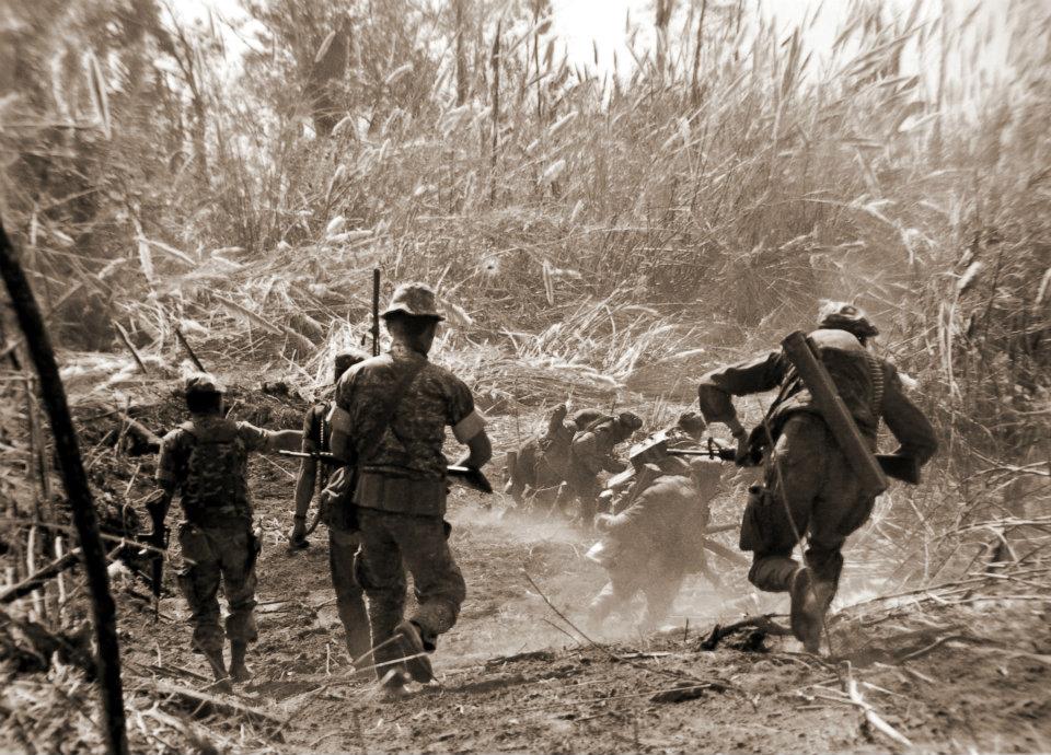
The history of Khao Kho cannot be separated from Thailand’s Cold War era. During the late 1960s through the early 1980s, the mountainous areas around Khao Kho became an important theatre of conflict involving the Thai government and the Communist Party of Thailand (CPT) insurgency.
The mountains provided natural advantages: difficult terrain, dense forest, steep ridges, concealed movement routes, strategic high ground and limited access from the lowlands. Government forces responded with military operations intended to regain control. The conflict was not a single battle. It was a prolonged series of operations. The commonly cited period is 1968–1982.
Why Khao Kho Was Strategic
Mountain ridges gave whoever controlled them a major advantage: observation, defensive positions, and terrain that made conventional operations difficult. The wider area also connected parts of Phetchabun with neighbouring mountain territory toward Phitsanulok and Loei.
This is why many of today’s roads and viewpoints have a different meaning through a historical lens. A road that now carries travellers to a viewpoint once had strategic importance. A quiet ridge that now attracts photographers once had military positions.
Khao Kho Sacrificial Monument
อนุสรณ์สถานผู้เสียสละเขาค้อ
One of the most important historical sites in the Khao Kho landscape is the Khao Kho Sacrificial Monument. It commemorates civilians, soldiers and police officers who lost their lives during the fighting.
The monument is distinctive for its triangular marble form, rising approximately 24 metres. Its three-sided form represents the cooperation and sacrifice of civilians, soldiers and police. The site was officially inaugurated on 20 February 1984, when King Bhumibol Adulyadej and Queen Sirikit visited the area.
Standing there today, the surrounding landscape is remarkably peaceful. That contrast is precisely what makes the site powerful.
The Bangkok Position
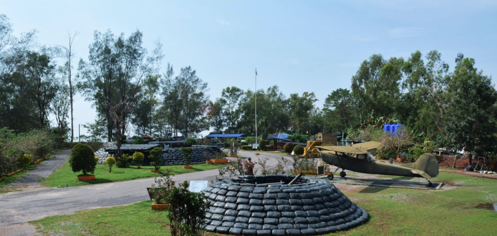
Near the memorial area are remnants associated with former military defensive positions, including trenches and bunkers. Unlike a conventional museum, the landscape itself becomes the exhibit. For visitors interested in history, this is a place to experience slowly rather than photograph and leave.
Itti Base — The Weapon Museum
ฐานอิทธิ
Itti Base occupies a former strategic military position. Today it displays military equipment associated with the conflict, including artillery, armoured vehicles, a tank and other battlefield equipment — much of it outdoors against the mountain landscape.
Weapons of war surrounded by the mountains that have now returned to peace.
Haw Chinese War Memorial
อนุสรณ์จีนฮ่อ
The memorial commemorates military personnel from the 93rd Division, a Chinese military formation whose members later became established in northern Thailand and whose forces participated in operations against Communist insurgents. Some were involved in the Khao Kho conflict.
The site helps place the battlefield within a wider Cold War regional context — beyond the conventional story of the Thai Army and the CPT insurgency.
Khao Kho Royal Palace
พระตำหนักเขาค้อ
The palace was constructed in the mid-1980s in connection with royal visits and the development of the region. The surrounding landscape had recently been associated with military conflict; the royal presence represented a different vision — community development, agriculture, environmental restoration and peaceful use of the highlands.
It is part of the story of Khao Kho’s transition from conflict zone to peaceful mountain destination.
Khao Kho Beyond the National Park
Khao Kho National Park is not the same thing as Khao Kho District or the entire Khao Kho tourism area.
Many famous attractions associated with a “Khao Kho trip” sit in the wider landscape rather than necessarily inside the legal park boundary:
- Khao Kho Sacrificial Monument
- Itti Base Weapon Museum
- Haw Chinese War Memorial
- Khao Kho Royal Palace
- Wat Phra That Pha Son Kaew
- Kanchanapisek Pagoda
- Khao Takhian Ngo
- local agricultural areas, mountain resorts and viewpoints
TAT itself presents the national park together with the palace, Itti Base, Wat Phra That Pha Son Kaew and the Haw Chinese War Memorial as a combined Phetchabun itinerary.
They belong to the Khao Kho destination ecosystem — not every landmark lies inside the park.
Wat Phra That Pha Son Kaew
วัดพระธาตุผาซ่อนแก้ว
Although it should not automatically be described as an attraction inside the national park, Wat Phra That Pha Son Kaew is one of the defining landmarks of the wider Khao Kho region. The temple sits dramatically among the mountains. On favourable mornings, clouds and mist can surround the landscape, creating one of Phetchabun’s most recognizable scenes.
Kanchanapisek Pagoda
พระบรมธาตุเจดีย์กาญจนาภิเษก
Another important cultural landmark in the wider area. Together with the memorials, royal sites and Buddhist landmarks, it shows that Khao Kho cannot be reduced to a nature destination alone.
What Makes Khao Kho Different?
Its identity comes from several overlapping layers rather than one dominant attraction.
- 01 — Mountains
- A broad highland landscape rather than a single isolated summit.
- 02 — Forest
- Protected mountain forest, wildlife habitat and watershed.
- 03 — Water
- Waterfalls, streams and forest drainage.
- 04 — Mist
- Weather that can transform valleys into a morning sea of cloud.
- 05 — History
- Former battlefields, memorials and military positions.
- 06 — Memory
- The region remembers the people who died rather than erasing the past. Names of roads, villages and bridges still carry that history.
- 07 — Peace
- The mountains that once witnessed conflict are now visited for rest, nature and contemplation.
The Khao Kho Experience
- Nature lovers
- Forest, waterfalls, ridges and viewpoints.
- Photographers
- Arrive before sunrise and work with changing mist, mountain layers and morning light.
- History lovers
- Follow the battlefield story through the Sacrificial Monument, Itti Base, former military positions and the Haw Chinese War Memorial.
- Slow travellers
- Stay in the mountains, wake before sunrise and allow weather to determine the day.
A better approach than a checklist is three layers: the landscape, the history, and the transformation from contested territory into a destination for conservation, agriculture, tourism and peaceful living.
When to Visit
Khao Kho has a relatively cool highland climate compared with Thailand’s lowland destinations.
- Cool season · November–February
- Generally the most comfortable period. Cool mornings, clearer air and favourable conditions for viewpoints.
- Hot season · February–May
- Temperatures rise, particularly outside early morning and evening. The highland can still feel considerably more comfortable than the lowlands.
- Rainy season · May–October
- The forest becomes particularly lush. Waterfalls can be more impressive, and clouds can create dramatic scenery. Heavy rain can affect trails and waterfall access — check current park conditions before remote routes.
Essential Information
- Destination
- Khao Kho National Park
- Province
- Phetchabun
- Area
- 301,698 rai / approximately 482.72 km²
- Status
- Thailand’s 125th national park · 18 May 2012
- Signature Experience
- Mountain viewpoints and sea of mist — when weather allows
- Historical Era
- Communist insurgency / Cold War · approximately 1968–1982
- Nearby Cultural Landmarks
- Royal Palace, Wat Phra That Pha Son Kaew, Kanchanapisek Pagoda
Frequently Asked Questions
- What is Khao Kho National Park?
- Thailand’s 125th national park, established on 18 May 2012 in Phetchabun. About 482.72 km² of highland forest, ridges, waterfalls and watershed across four districts.
- Is every Khao Kho attraction inside the park?
- No. The park is not the same as Khao Kho District or the whole tourism area. Memorials, Itti Base, the palace and Wat Phra That Pha Son Kaew belong to the wider destination.
- Can I see the sea of mist every morning?
- No. Mist is weather, not a scheduled attraction. Cooler months and conditions after rain can help. Come early enough to give nature a chance.
- Why is Khao Kho historically important?
- From about 1968 to 1982 the mountains were a theatre of the Communist insurgency. Memorials, former military positions and Itti Base remain in the wider landscape.
- When is the best time to visit?
- November–February is generally most comfortable for viewpoints. The rainy season can make waterfalls stronger. Check current park conditions before remote routes.
- How do I contact the park?
- DNP lists 0 8128 45223. Headquarters are in Sado Phong, Khao Kho District, Phetchabun 67270.
Related Destinations
- Phu Hin Rong Kla National Park
- The neighbouring highland to the north — another landscape where forest and Cold War history occupy the same mountains.
- Tat Mok National Park
- Waterfalls and forest in Phetchabun, another side of the province’s protected highlands.
- Nature & Parks
- More protected landscapes across ThailandLover’s national-park collection.
Location
Find Khao Kho National Park
Sado Phong, Khao Kho, Phetchabun 67270