


National Park · Prachuap Khiri Khan
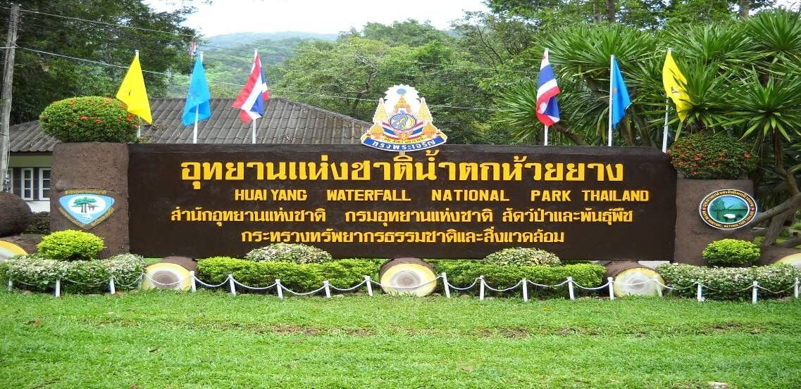
Namtok Huai Yang National Park
อุทยานแห่งชาติน้ำตกห้วยยาง
Where the Mountains Meet the Sea
Thap Sakae · Mueang Prachuap Khiri Khan · Bang Saphan
Follow the forest streams of the Tenasserim Range from Huai Yang Waterfall toward Khao Luang and the Gulf of Thailand.
A Mountain-to-Sea Landscape
There are places in Thailand where the mountains feel far removed from the sea.
Namtok Huai Yang National Park is not one of them.
Here, the Tenasserim mountain range rises sharply from the narrowest part of Thailand, creating forests, streams and waterfalls only a short distance from the Gulf of Thailand.
At the centre of the park is Huai Yang Waterfall, formed by the Huai Yang stream as it descends from the mountain landscape of Khao Luang. But the waterfall is only the beginning.
Beyond the cascades are mountain forests, watershed valleys, wildlife habitat, rare freshwater species and a rugged highland landscape that eventually reaches the natural boundary between Thailand and Myanmar.
For ThailandLover, Huai Yang is best understood not as a single waterfall attraction, but as a mountain-to-sea landscape — a place where the Tenasserim Range, forest watersheds and the Gulf of Thailand exist remarkably close together.
At a Glance
- Official English Name
- Namtok Huai Yang National Park
- Thai Name
- อุทยานแห่งชาติน้ำตกห้วยยาง
- Province
- Prachuap Khiri Khan
- Districts
- Mueang Prachuap Khiri Khan, Thap Sakae and Bang Saphan
- Established
- 8 December 1991
- National Park Number
- 70th national park of Thailand
- Gazetted Area
- 100,625 rai / approximately 161 km²
- Mountain Range
- Tenasserim Range
- Main Summit
- Khao Luang · approximately 1,250 m
- Main Waterfall
- Huai Yang Waterfall
- Main Watercourse
- Huai Yang stream
- Landscape
- Mountain forest, watershed, waterfalls and foothills
- Border Landscape
- Natural Thailand–Myanmar frontier
- Nearest Major Town
- Thap Sakae / Prachuap Khiri Khan
- Park Character
- Waterfalls, forest, hiking, wildlife and mountain landscapes
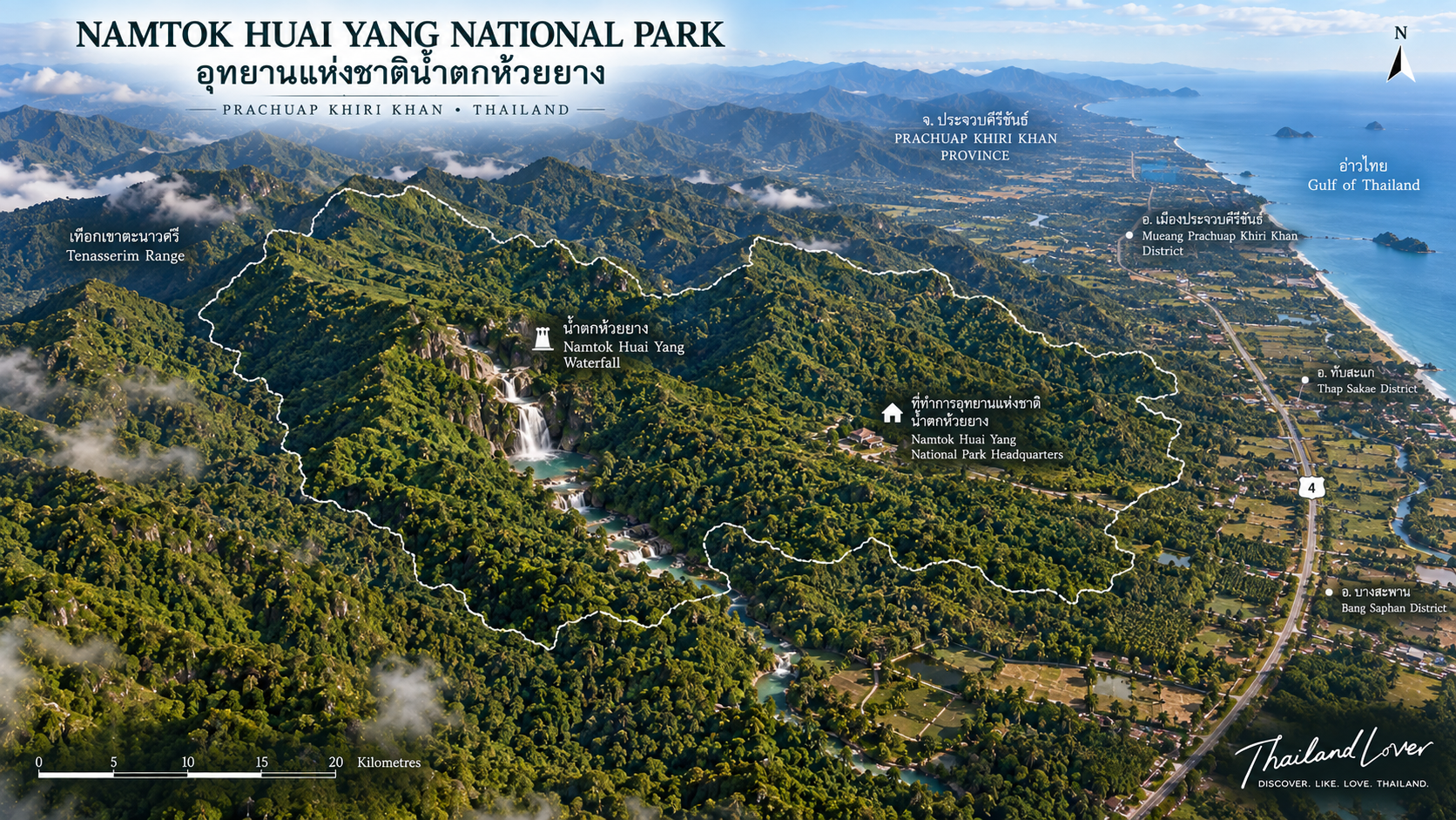
The Department of National Parks currently lists Namtok Huai Yang National Park as covering parts of Bang Saphan, Thap Sakae and Mueang Prachuap Khiri Khan districts. The park covers approximately 100,625 rai, or 161 square kilometres.
It was gazetted on 8 December 1991 as Thailand’s 70th national park.
The Landscape
A Narrow Country Between Mountain and Sea
Prachuap Khiri Khan is geographically unusual. The province forms one of the narrowest sections of Thailand, with the Tenasserim mountain system running close to the country’s western boundary and the Gulf of Thailand lying to the east.
Namtok Huai Yang National Park occupies part of this mountain landscape. The result is a dramatic geographic relationship:
Mountain → Forest → Stream → Lowland → Gulf of Thailand
The park is therefore more than a collection of waterfalls. It is a watershed landscape. Streams descending from the Tenasserim Range supply water to lower-lying areas and form the ecological backbone of the park.
The Tenasserim Range
Thailand’s Western Mountain Frontier
The park lies within the Tenasserim Range, one of the major mountain systems of mainland Southeast Asia. The range forms much of the natural frontier between Thailand and Myanmar.
In the Huai Yang landscape, the mountains are not simply scenic backdrops. They determine elevation, rainfall, stream formation, forest distribution, wildlife habitat and the direction of water flowing toward the lowlands.
The western mountain zone also creates a natural ecological transition between Thailand’s central peninsula and the forest systems farther west.
Khao Luang
The High Point of Huai Yang
At the heart of the park’s mountain landscape is Khao Luang, the highest summit in Namtok Huai Yang National Park. Published park references place the summit at approximately 1,250 metres above sea level.
Khao Luang is considerably more remote than the main waterfall. The Department of National Parks currently describes the route from the park headquarters, passing through the Huai Yang Waterfall area and continuing into the mountain. The climb takes approximately 5–6 hours on foot, with much of the route steep and only short sections of relatively level ridge. Access is seasonal and requires coordination with park officials.
This is not a casual waterfall walk. It is a genuine mountain excursion.
The Thailand–Myanmar Frontier
A Mountain Boundary
One of the most significant geographic characteristics of Khao Luang is its relationship with the international border. The Department of National Parks describes the summit area as part of the natural boundary between Thailand and Myanmar.
This gives the mountain a significance beyond its elevation. The landscape is simultaneously a watershed, a mountain ecosystem, a national-park landscape and part of a transboundary mountain system.
From a ThailandLover perspective, this is one of the details that separates Huai Yang from an ordinary waterfall destination.
Huai Yang Waterfall
The Waterfall That Gives the Park Its Name
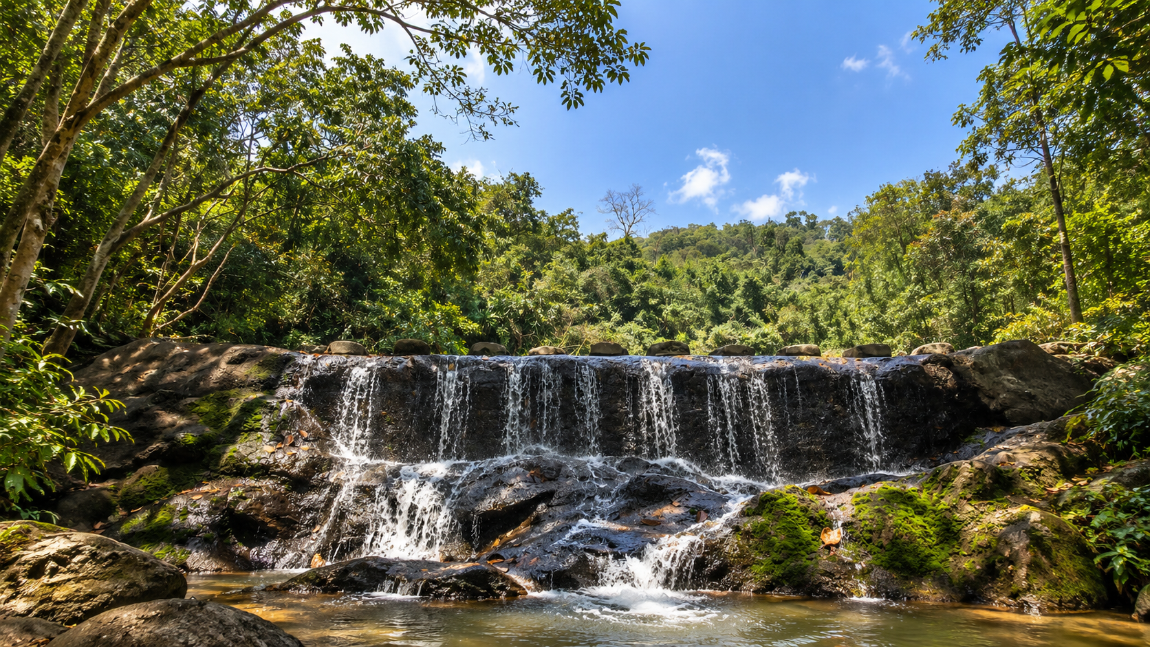
Huai Yang Waterfall is the park’s signature attraction and the feature from which the national park takes its name. The waterfall is formed by the Huai Yang stream, which descends from the forested mountain landscape of Khao Luang.
Unlike Thailand’s giant vertical waterfalls, Huai Yang is characterized by a sequence of smaller cascades, rock shelves and pools. The landscape is intimate rather than monumental. Water moves through granite and rocky terrain, collecting in pools before continuing downstream.
How Many Levels Does Huai Yang Waterfall Have?
Why You May See Different Numbers
This is one of the details that requires caution. Different Thai government and tourism documents describe the waterfall using different numbers of levels.
The Office of Natural Resources and Environmental Policy and Planning (ONEP) currently describes Huai Yang Waterfall as a five-tier waterfall. Its environmental profile identifies five principal levels and places the waterfall at approximately 80 metres above mean sea level.
Other official and local tourism documents describe the waterfall as having seven or nine levels, reflecting either different ways of counting individual cascades or different historical descriptions of the waterfall system.
The Main Waterfall Experience
The visitor experience begins close to the park headquarters. From there, a nature trail follows the stream into the forest.
The sounds of the visitor area disappear. · The forest becomes denser. · The stream becomes more prominent. · Rock shelves appear. · Then the first cascades begin.
The attraction is not a single viewpoint. It is the progression through the forest alongside the water.
Rock, Water and Forest
Huai Yang Waterfall is especially attractive because of the relationship between three elements:
- Rock
- Large exposed rocks create natural channels, shelves and pools.
- Water
- The Huai Yang stream continuously reshapes the landscape and creates the cascades.
- Forest
- Vegetation surrounds the stream, creating shade and a humid microclimate.
ONEP identifies the geological setting around the waterfall as including granite and lateritic material. The result is a waterfall landscape that feels very different from the broad limestone terraces found at some other Thai waterfalls.
The Forest Around the Falls
A Mountain Forest Mosaic
The wider national park contains several forest environments associated with elevation and moisture. Published descriptions identify hill evergreen forest, dry evergreen forest, mixed forest communities, bamboo and other vegetation associated with mountain watersheds.
The waterfall environment itself is noticeably wetter than the surrounding lower landscape, creating a distinct riparian environment around the stream.
ONEP’s environmental profile of Huai Yang Waterfall describes surrounding vegetation as mixed deciduous forest, with trees such as Lagerstroemia, Terminalia and Ficus, together with bamboo in the understory.
The waterfall is not an isolated natural feature. It is a product of the mountain watershed around it.
The Water Source
From Khao Luang to the Lowlands
The Huai Yang stream originates in the mountain landscape of the Tenasserim Range. Rainfall is captured by the forest and released through streams and tributaries. As the water descends, gravity creates the cascades of Huai Yang Waterfall.
The waterfall therefore represents only one visible point in a much larger hydrological system. The actual landscape begins much higher in the mountains.
Dry Season vs. Rainy Season
The Waterfall Changes with the Weather
Huai Yang is a rainfall-dependent waterfall. ONEP specifically notes that the waterfall has less water during the dry season.
- Wetter Periods
- The stream becomes stronger; pools fill more quickly; cascades become more continuous; the surrounding forest becomes intensely green.
- Drier Periods
- Water flow can become significantly lower; more rock surfaces become visible; some smaller cascades may lose much of their flow; the landscape becomes quieter and more exposed.
The waterfall should therefore be understood as a seasonal mountain water system, not a fixed photographic scene.
Wildlife
A Forest Connected to the Tenasserim Mountains
The park’s forest provides habitat for a variety of mammals and birds. Published park information records wildlife including:
- Mainland serow
- Indochinese leopard
- Wild boar
- Indian muntjac
- Malayan porcupine
- Dusky langur
- Gibbons
- Squirrels and numerous forest birds
Birds recorded in older tourism material
- Great hornbill
- Green pigeon
- Hill myna
- Barbets
- Bulbuls
- Red junglefowl
These should be understood as species associated with the wider park ecosystem rather than animals that visitors are guaranteed to encounter.
The Panda Crab
One of the Park’s Most Remarkable Small Animals
One of Huai Yang’s most interesting biological stories is not a large mammal. It is a tiny freshwater crab.
The Panda Crab, scientifically known as Phricotelphusa sirindhorn, is associated with clean mountain streams and waterfalls in western Thailand. The species has been recorded at Huai Yang Waterfall as well as several other waterfall systems in western Thailand.
Its striking black-and-white coloration gives it the familiar “panda crab” name. Because it depends on mountain-stream environments, its presence is closely connected with the quality and ecological integrity of the water system.
For visitors, this is a species to observe only if encountered naturally. It should never be collected, handled or disturbed.
Why the Panda Crab Matters
The Panda Crab provides a useful way to understand the park. A waterfall is not only scenery. Its water supports an entire ecological community.
Small aquatic animals depend on clean water, suitable stream temperatures, rocky streambeds, oxygen-rich flowing water and intact forest around the watershed.
Protecting the waterfall therefore means protecting the mountain ecosystem that feeds it.
Other Waterfalls in the Park
Huai Yang is not the only waterfall within the national park. The wider protected area contains several waterfall systems.
Khao Lan Waterfall
A larger waterfall system located south of the main park area. Older official tourism information describes water descending from a cliff of approximately 50 metres, with a pool at the upper level. Access involves travelling from the main road to the park unit and continuing on foot. Khao Lan is particularly associated with the rainy season, when water volume increases.
Kha On Waterfall
Also known as Thap Mon
Located in the Bang Saphan section of the national park. Published tourism information describes it as a multi-level cascade, historically described as having nine levels. It is considerably farther from the main visitor area than Huai Yang Waterfall and should therefore be treated as a separate excursion rather than a quick add-on.
Huai Hin Dat Waterfall
Another waterfall system associated with the wider park landscape. Older tourism documentation describes a stream approximately six metres wide flowing through multiple waterfall levels. As with the other secondary waterfalls, conditions and access can depend strongly on rainfall and local management.
Other Forest Water Features
Historical tourism material also records additional waterfall locations, including Bua Sawan Waterfall.
Namtok Huai Yang is a watershed park, not simply a park built around one waterfall.
Khao Luang as a Wildlife Landscape
The higher elevations around Khao Luang provide a substantially different environment from the lower waterfall area. As elevation increases, temperatures become cooler, forest structure changes, streams become narrower, terrain becomes steeper and human access decreases.
This creates conditions suitable for wildlife that is less commonly encountered around the main visitor zone. The mountain should therefore be understood as the ecological core behind the waterfall system.
Hiking to Khao Luang
For Experienced Hikers
The route to Khao Luang is significantly more demanding than the waterfall trail. The DNP describes the route from the park headquarters through the Huai Yang waterfall area toward the summit as taking approximately 5–6 hours on foot, with much of the trail steep.
The summit route is not a casual self-guided attraction. Visitors wishing to climb Khao Luang must contact the national park and follow current instructions from park officials.
The DNP currently states that the summit route is open for tourism during approximately June–March, subject to park management and conditions. This seasonal detail should always be rechecked before a trip.
The View from the Mountains
One of the most distinctive characteristics of Huai Yang is the relationship between mountain and sea. The mountains are high enough to provide elevated viewpoints, yet the Gulf of Thailand is relatively close.
At appropriate viewpoints, the landscape opens eastward toward the coastal plain and Gulf. This creates one of the park’s defining visual relationships:
Forest in the foreground · Lowlands below · The sea beyond
Some viewpoints associated with the waterfall and mountain trails are particularly attractive around sunrise. As the sun rises over the Gulf of Thailand, the lowlands become visible beyond the forest.
At the falls, the landscape is intimate. From the mountain, it becomes expansive.
A Park Between Two Worlds
- To the East
- The Gulf of Thailand
- To the West
- The Tenasserim Range and the Myanmar frontier
- Between Them
- Forest, streams and lowland settlements
The park is therefore a physical bridge between coastal and mountain environments. This geographic position is one of its strongest stories.
History of the National Park
From Reserved Forest to National Park
The modern protected landscape was formed by combining forest areas including the Wang Duan and Huai Yang reserved forests. The area was subsequently upgraded into a national park.
On 8 December 1991, Namtok Huai Yang National Park was formally established as Thailand’s 70th national park. The park’s gazetted area is approximately 100,625 rai, equivalent to about 161 square kilometres.
A Royal Connection
Huai Yang in Thailand’s Modern Environmental Memory
Huai Yang Waterfall also has an important place in Thailand’s modern environmental history. On 16 May 1959, King Bhumibol Adulyadej and Queen Sirikit visited Huai Yang Waterfall in Prachuap Khiri Khan.
The Department of National Parks has highlighted this visit as part of the country’s long history of forest conservation awareness.
The importance of the visit is not simply ceremonial. It forms part of a much longer Thai narrative in which forests, watersheds and the relationship between water and human communities became increasingly important subjects of conservation.
The Meaning of “Huai Yang”
The name refers to the Huai Yang stream and the surrounding locality. In Thai geographic naming, “huai” commonly refers to a stream or small watercourse.
The park therefore takes its name directly from the landscape that defines it: the Huai Yang water system.
The Narrowest Thailand
Prachuap Khiri Khan is famous for being one of the narrowest parts of Thailand. The western mountains and the Gulf are separated by a relatively narrow strip of land.
Namtok Huai Yang lies within this unusual geographic setting. This makes the park particularly interesting for travellers who want to understand Thai geography.
You are not simply visiting a waterfall. You are standing inside one of the country’s most compressed mountain-to-sea landscapes.
Why the Forest Matters More Than the Waterfall
The waterfall is what people come to see. The forest is what makes the waterfall possible.
Without the mountain forest, rainfall would move more rapidly across the landscape; streams would become less stable; erosion would increase; wildlife habitat would decline; and the waterfall system would change.
The forest is therefore the infrastructure behind the scenery. This is the ecological story at the heart of Huai Yang.
The Waterfall as a Living System
A waterfall may look like a static object. It is not.
Rain falls on the mountains. · Water enters the forest. · Streams gather. · Gravity pulls water downhill. · Rock redirects the flow. · Pools slow it down. · Plants stabilize the banks. · Aquatic organisms live in the current. · The water continues toward the lowlands.
The waterfall is simply the visible point where this process becomes spectacular.
Responsible Travel
Protect the Watershed
Huai Yang is a relatively accessible national park, but the environment remains sensitive. Visitors should:
- Stay on designated trails
- Follow ranger instructions
- Avoid entering closed areas
- Never collect plants, animals or rocks
- Avoid feeding wildlife
- Carry rubbish out where required
- Avoid soaps and chemicals in streams
- Keep noise low
- Never enter waterfalls during dangerous water conditions
The Panda Crab and other stream-dependent species are especially sensitive to disturbance. The cleanest-looking stream is not necessarily an invitation to handle its wildlife.
Water Safety
Respect the Mountain Water
Mountain waterfalls can change quickly. Rainfall upstream may increase water volume and current strength even when the immediate area appears calm. Rock surfaces can also become extremely slippery.
This is particularly important at Huai Yang because the waterfall trail includes natural rocks and streamside terrain. Older risk assessments of the park identified the waterfall area itself as a significant location for visitor accidents, with slipping and flash-flood conditions among the hazards.
If park staff restrict access to the water, do not enter.
When to Visit
Choose Between Water and Hiking
- Rainy Season
- Best for: waterfall flow and green forest. Secondary waterfalls such as Khao Lan can also become more attractive. Trails become slippery and heavy rain can create dangerous stream conditions.
- Cool Season
- Best for: hiking and mountain exploration. Cooler months are generally more comfortable for walking. Khao Luang may also be accessible during the park’s permitted hiking season, subject to current conditions and ranger approval.
- Dry Season
- Best for: quieter forest experiences. Water flow can be lower — ONEP specifically notes less water during the dry season — but the surrounding forest can still be worthwhile.
Who Should Visit?
Namtok Huai Yang works particularly well for travellers who enjoy:
- Waterfalls — an accessible introduction to the park
- Forest walks — more immersive than viewing a waterfall from a road
- Photography — forest, rock, flowing water and mountain scenery
- Birdwatching — a variety of forest bird species
- Wildlife — mammals and stream-dependent species in the wider protected area
- Hiking — the demanding Khao Luang route with park guidance
- Geography — Thailand’s mountains, border and Gulf coast in one compressed landscape
Photography Guide
- The Waterfall
- Use the rock terraces and surrounding vegetation to frame the water. The strongest images show the relationship between forest + rock + water.
- The Forest
- Look upward. The canopy can provide stronger images than the waterfall itself, particularly when sunlight breaks through the leaves.
- The Mountain
- Use layered ridges, forest texture, distant lowlands and, where visible, the Gulf of Thailand.
A ThailandLover Day
- Morning
- Arrive early. The forest is cooler, quieter and more atmospheric. Walk toward Huai Yang Waterfall and follow the stream rather than rushing directly to the main viewpoint.
- Late Morning
- Explore the waterfall sequence. Spend time observing the rock formations and pools. If conditions allow and swimming is officially permitted, use only designated areas.
- Afternoon
- Return through the forest. Allow time for birdwatching and photography. Overnight camping offers a chance to experience the forest after day visitors have left.
If You Have More Time
Huai Yang works better as part of a wider Prachuap Khiri Khan itinerary. Possible combinations include Huai Yang Waterfall, Thap Sakae, Prachuap Khiri Khan town, Gulf coast beaches and other nearby protected areas.
The key is not to treat the waterfall as an isolated stop. The landscape becomes more meaningful when viewed from mountain to coast.
Practical Visitor Information
Location
Namtok Huai Yang National Park is in Prachuap Khiri Khan Province, covering areas of Mueang Prachuap Khiri Khan District, Thap Sakae District and Bang Saphan District. The principal waterfall and park headquarters are associated with Huai Yang Subdistrict, Thap Sakae District.
Getting There
The main visitor area is accessible from Phetkasem Road (Highway 4). From the main highway, visitors turn toward Huai Yang and continue inland toward the national park.
The park is also geographically connected to Huai Yang railway station on Thailand’s Southern Railway line. For international visitors, private transport is generally the most flexible option because the national park covers a large mountain area and its attractions are spread across different sections.
Distance and Orientation
The park is south of central Prachuap Khiri Khan. Published travel information places the main waterfall entrance roughly 27–36 kilometres south of Prachuap Khiri Khan town, depending on the reference point used. The park is relatively close to the main Phetkasem corridor but becomes progressively more mountainous as you travel inland.
Facilities
The main visitor area has basic national-park infrastructure, including visitor facilities, walking trails, camping areas, toilets, accommodation in the park system and basic food/service facilities. Availability can vary by season and park operating conditions. DNP’s reservation system is the appropriate source for current accommodation availability.
Entrance Fees
National-park entrance fees can change according to DNP policy. ThailandLover does not hard-code a fee here. Treat the current DNP reservation and park information systems as the authoritative reference for operational fees and conditions.
Opening Conditions
What to Bring
- Main Waterfall
- Comfortable walking shoes, water, sun protection, insect repellent, a small towel, change of clothes if swimming is currently permitted, and waterproof protection for electronics.
- Khao Luang
- Proper hiking footwear, sufficient water, food for a long hike, rain protection, headlamp, first-aid supplies and any equipment required by park officials. Attempt the summit only according to current ranger instructions.
Frequently Asked Questions
- What is Namtok Huai Yang National Park?
- Thailand’s 70th national park, established on 8 December 1991. It covers about 100,625 rai (161 km²) across three districts of Prachuap Khiri Khan and is known for Huai Yang Waterfall, Khao Luang and Tenasserim mountain forests close to the Gulf.
- How many levels does Huai Yang Waterfall have?
- ONEP currently describes five principal levels; other documents historically cite seven or nine. ThailandLover describes it as a multi-level forest waterfall rather than locking to a single number.
- Where is the park?
- In Prachuap Khiri Khan — Mueang Prachuap Khiri Khan, Thap Sakae and Bang Saphan. Headquarters and the main waterfall are associated with Huai Yang, Thap Sakae, inland from Highway 4.
- Can you hike Khao Luang?
- Yes, with park coordination. Expect roughly 5–6 hours of steep walking from headquarters. The route is typically open around June–March — always recheck with rangers.
- When is the best time to visit?
- Rainy season for stronger waterfall flow; cool season for hiking comfort; dry season for quieter forest but often less water.
- What is the Panda Crab?
- Phricotelphusa sirindhorn — a black-and-white freshwater crab of clean mountain streams. Observe only if encountered naturally; never collect or handle it.
- Are there other waterfalls?
- Yes — including Khao Lan, Kha On (Thap Mon), Huai Hin Dat and others. Treat them as separate excursions; access depends on rainfall and park management.
- What are the entrance fees?
- Fees change with DNP policy. Check current official DNP information before travelling.
Related Destinations
- Hat Wanakon National Park
- Gulf coastline near Huai Yang — beaches, islands and marine landscape on the same Phetkasem corridor.
- Kaeng Krachan National Park
- Thailand’s great Tenasserim wilderness farther north — a deeper mountain-forest counterpart.
- Namtok Chet Sao Noi National Park
- Another waterfall national park — accessible cascades on the Muak Lek stream in Saraburi.
- Nature & Parks
- More protected landscapes across ThailandLover’s national-park collection.
Location
Find Namtok Huai Yang National Park
Huai Yang, Thap Sakae, Prachuap Khiri Khan