


Marine National Park · Trat
Mu Ko Chang National Park
อุทยานแห่งชาติหมู่เกาะช้าง
Thailand’s Island of Rainforest and Sea
Trat · Eastern Thailand · Gulf of Thailand
A mountainous island, a chain of smaller islands, rainforest, waterfalls and coral — one protected landscape, not a resort beach with a national-park name attached.
At a Glance
Mu Ko Chang National Park is one of Thailand’s great eastern marine national parks — a vast protected landscape where a mountainous tropical island, surrounding smaller islands, rainforest, waterfalls, beaches, mangroves and coral reefs form one interconnected ecosystem.
Established on 31 December 1982, it became Thailand’s 45th national park. The park covers approximately 650 square kilometres / 406,250 rai. Around 70 percent of the protected area is marine.
The archipelago contains more than 40 islands. Commonly cited official tourism information describes 52 islands within the national park landscape.
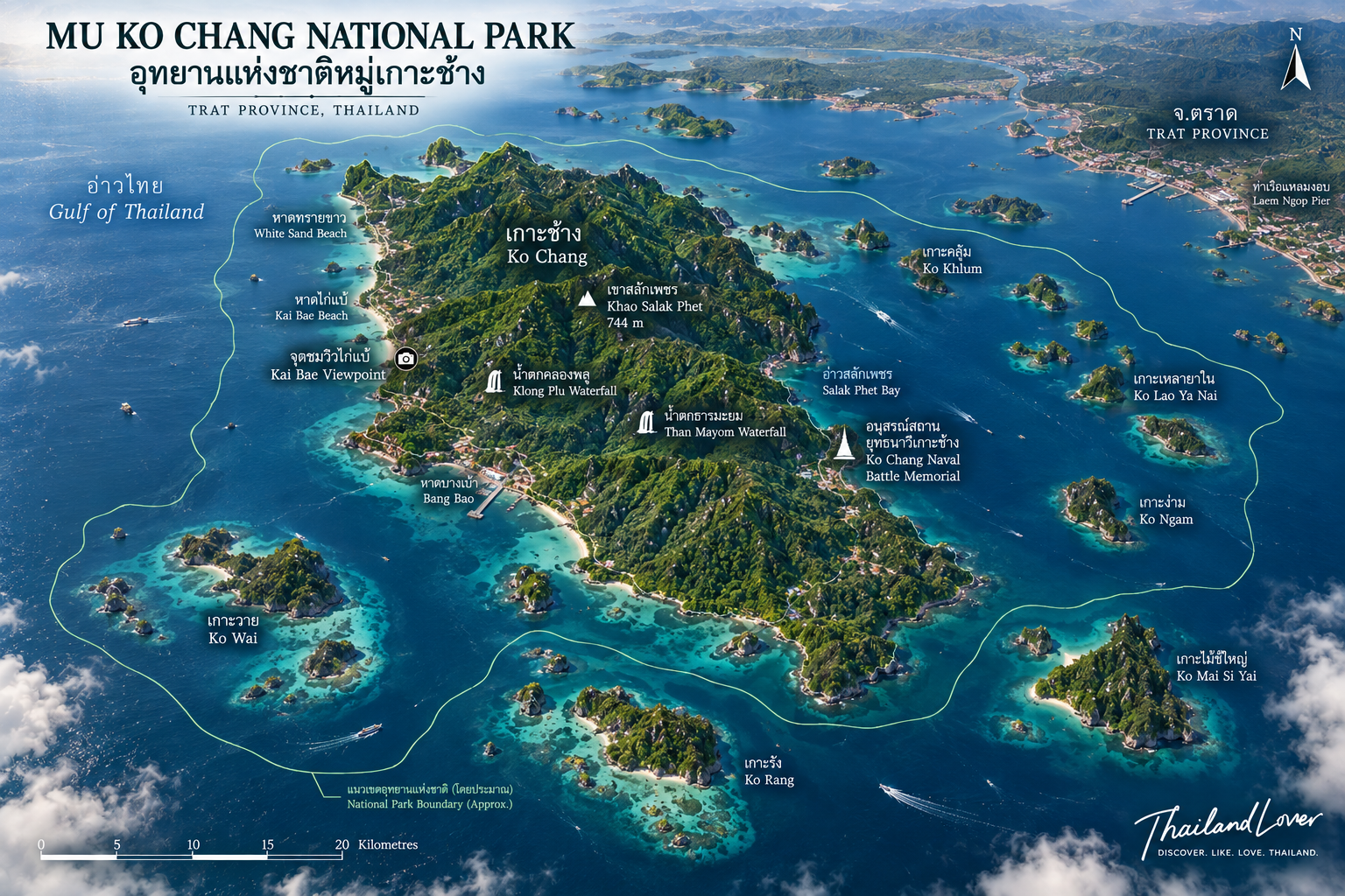
At its centre is Ko Chang — Elephant Island, Thailand’s second-largest island after Phuket by area. But the park is not simply Ko Chang. It also encompasses a wider archipelago, including areas around Ko Rang, Ko Wai, Ko Ngam, Ko Khlum, Ko Lao Ya and other islands and islets.
Mountain rainforest above the sea, waterfalls descending through forest, villages along sheltered bays, and coral reefs around offshore islands.
That combination is what makes Mu Ko Chang different.
Essential Facts
- Official Name
- Mu Ko Chang National Park
- Thai Name
- อุทยานแห่งชาติหมู่เกาะช้าง
- Province
- Trat
- Region
- Eastern Thailand
- Sea
- Gulf of Thailand
- Established
- 31 December 1982
- National Park Number
- 45th
- Total Area
- About 650 km² / 406,250 rai
- Marine Area
- About 503 km² · roughly 70%
- Archipelago
- About 52 islands in Thai tourism and park references
- Main Island
- Ko Chang · about 429 km²
- Highest Point
- Khao Salak Phet · about 743–744 m
- Main Waterfalls
- Than Mayom, Khlong Phlu, Khlong Nonsi, Khlong Nueng, Khiri Phet
- Major Marine Area
- Mu Ko Rang
- Main Communities
- Salak Phet, Salak Khok, Bang Bao, Khlong Son and others
- Historical Event
- Battle of Ko Chang, 17 January 1941
- Main Gateway
- Laem Ngop / Trat
- Main Access
- Vehicle ferry and passenger boat
- Park Authority
- Department of National Parks, Wildlife and Plant Conservation
The Meaning of Ko Chang
The name Ko Chang means “Elephant Island.” The island’s outline and prominent headlands have traditionally been associated with the shape of an elephant. The name is not derived from a native elephant population. Elephants are not indigenous wildlife of Ko Chang.
The island’s real natural identity is much more closely connected to mountain forests, freshwater streams, waterfalls, coastal ecosystems, coral reefs and small offshore islands. The elephant is a name and a symbol, not the ecological foundation of the island.
Where Is Mu Ko Chang National Park?
Mu Ko Chang National Park is in Trat Province in eastern Thailand, in the Gulf of Thailand close to the Cambodian border. The protected area extends around the Ko Chang archipelago and includes marine waters and islands associated with the wider Trat island group.
Administratively, the park is associated principally with the Ko Chang and Ko Kut districts of Trat Province. It lies offshore from the mainland coast around Laem Ngop, Trat and Khlong Yai. The main gateway is the Laem Ngop area, from which vehicle ferries and passenger boats connect with the island.
A National Park — Not Just an Island
This distinction is fundamental. When people say “Koh Chang,” they often mean the developed tourist island. When ThailandLover says Mu Ko Chang National Park, we mean the much larger protected landscape:
islands + forest + waterfalls + coastal habitats + coral reefs + surrounding sea
Some famous tourist beaches and developed areas of Ko Chang sit within or alongside the broader protected landscape but are not themselves synonymous with “the national park.” Some attractions marketed under the Koh Chang tourism brand are outside the park’s legally protected boundaries. For accurate travel writing, the two should not be treated as interchangeable.
The Geography of Ko Chang
Ko Chang is a large mountainous island approximately 30 kilometres long and 14 kilometres wide. Its total island area is generally given at around 429 square kilometres in local geographic references, although different datasets use slightly different measurement conventions.
A long mountain ridge runs through much of the interior. The result is a dramatic contrast: mountain in the centre, sea around it, settlements concentrated along the coast. The western side has become the main tourism corridor. The eastern and southern sides retain more extensive forest, fishing communities, sheltered bays and quieter coastal landscapes.
Khao Salak Phet
เขาสลักเพชร · The Roof of Ko Chang
The highest mountain on Ko Chang is Khao Salak Phet, rising to approximately 743 metres above sea level. Some tourism sources round this to 744 metres. The difference is insignificant for travel purposes. What matters is that Khao Salak Phet is the island’s highest summit.
It lies in the southern part of the island and forms part of the rugged interior that gives Ko Chang its silhouette. Unlike low-lying resort islands, Ko Chang is fundamentally mountainous. That explains nearly everything about its natural environment.
Why Ko Chang Has So Many Waterfalls
High mountains plus heavy rainfall produce abundant freshwater. Rain falls on the forested slopes, collects in streams and descends through steep terrain toward the coast. Among the best-known waterfalls are Than Mayom, Khlong Phlu, Khlong Nonsi, Khlong Nueng and Khiri Phet.
These are not isolated scenic attractions. They are expressions of the island’s watershed. The forest captures rainfall. The mountains channel it. The streams carry it downhill. The waterfalls reveal the elevation change. And the freshwater ultimately reaches the sea.
Than Mayom Waterfall
น้ำตกธารมะยม · Where Nature Meets Royal History
Than Mayom Waterfall lies on the eastern side of Ko Chang, close to the national park headquarters. Members of the Thai royal family visited the area, including King Rama V, King Rama VI and King Rama VII. King Rama V visited Ko Chang in 1876, and royal inscriptions associated with his visit remain on rock near the waterfall.
Than Mayom is simultaneously a waterfall, a forest landscape and a piece of Thai royal history. The waterfall itself consists of multiple cascades, with the upper sections generally regarded as the most impressive.
Khlong Phlu Waterfall
น้ำตกคลองพลู · Ko Chang’s Classic Forest Waterfall
On the western side of Ko Chang, Khlong Phlu Waterfall is one of the island’s best-known natural attractions. A forest trail from the Khlong Phlu entrance is relatively short compared with major mountain treks, but the terrain can be uneven and slippery after rain. The waterfall descends through a rocky gorge into a natural pool.
When rainfall is sufficient, green forest, granite rock and falling water create one of the most photogenic freshwater landscapes on the island. During prolonged dry periods, the volume can decrease substantially. A waterfall is not a permanent stage set. It responds directly to rainfall.
The Quieter Waterfalls
Khlong Nonsi Waterfall
North-eastern Ko Chang
Khlong Nonsi is quieter than Khlong Phlu. It suits visitors who prefer forest walking, fewer crowds, local landscapes and a slower experience. The eastern side of Ko Chang generally feels less dominated by resort tourism than the main western beach corridor.
Khlong Nueng Waterfall
Near Salak Phet
Near the southern community of Salak Phet, Khlong Nueng is known for a narrow rocky setting and a relatively dramatic vertical drop. The route can be more demanding than the easier waterfall walks. Ko Chang’s waterfalls are mountain environments, not theme-park attractions. Trail conditions can change rapidly after heavy rain.
Khiri Phet Waterfall
Southern Ko Chang
Khiri Phet can be combined with exploration of the southern side of the island, where the landscape becomes forest, plantations, fishing communities, sheltered bays and offshore islands. This is the side of Ko Chang that reveals the island beyond its resort image.
The Forest and the Geology
The natural character of Ko Chang is strongly associated with humid tropical forest. The island receives substantial rainfall, particularly during the south-west monsoon. Vegetation communities include moist evergreen forest, evergreen forest, coastal forest, mangrove, secondary vegetation around settled areas, and forest along streams and waterfalls.
Botanical research has documented a distinctive flora associated with the island’s granitic mountain landscape. The forest is not merely scenery. It is the island’s infrastructure. Without it there would be less water, fewer streams, fewer waterfalls and less habitat.
One of the lesser-known facts about Ko Chang is that its mountains are not primarily limestone. The underlying rocks are largely granitic. Botanical and geographical studies place the formation of the major granitic rocks in the region roughly 230–195 million years ago. This helps explain the rounded mountain forms and distinguishes Ko Chang from limestone landscapes such as Krabi, Phang Nga, Phi Phi and Mu Ko Ang Thong.
Granite mountains, rainforest, waterfalls and sea. A different geological world.
The Marine World of Mu Ko Chang
Although Ko Chang itself is enormous compared with most Thai islands, the national park’s identity is equally marine. Approximately 70 percent of the park’s total area is sea: coral reefs, sandy seabeds, rocky shores, mangrove, seagrass and coastal habitats, shallow bays, offshore islands and open Gulf waters.
Calling Mu Ko Chang simply a “jungle island” is incomplete. It is a marine national park built around a mountainous island system.
The waters around the smaller islands contain important coral communities, particularly around Ko Rang, Ko Wai, Ko Ngam and other southern offshore islands. The eastern Gulf is not identical to the Andaman Sea. Visibility varies with weather, wind, rain, sediment, currents and season. Good days can be excellent. Other days are less impressive. ThailandLover would rather state this honestly than promise crystal-clear water every day.
The Offshore Islands
Ko Rang
เกาะรัง · The Marine Gateway
Mu Ko Rang lies south-west of Ko Chang and west of Ko Mak, surrounded by coral habitats and shallow marine environments. It is known for snorkelling, diving, coral observation, small beaches and bird habitat. For travellers whose primary objective is underwater exploration, Ko Rang is often more important than the beaches of the main island.
Ko Wai
เกาะหวาย · A smaller rhythm
South of Ko Chang, Ko Wai is known for quiet beaches, coral, snorkelling and a small-island atmosphere. Fewer roads. Fewer buildings. More sea. You do not have to experience the park only from the main island.
Ko Ngam
เกาะง่าม · Two landforms, one island
Ko Ngam is characterised by two main landforms connected by a narrow area, producing sheltered waters and distinctive island scenery, particularly attractive from the sea. The smaller islands are not simply decorative satellites of Ko Chang. They form a network of marine habitats with their own ecological significance.
Mangroves and Coastal Forest
Mangrove ecosystems occur in suitable sheltered coastal areas, especially around protected bays and estuarine environments. They stabilise shorelines, trap sediment, provide nursery habitat, support coastal food webs and protect shorelines from wave energy. For an island national park, mangroves are part of the defence system. They help connect the land ecosystem with the sea.
Between inland rainforest and the sea is a transitional coastal environment. Beach forest and coastal vegetation must tolerate salt spray, strong sunlight, wind, sandy or rocky soils and periodic drought. These habitats are often overlooked by visitors rushing toward the beach. Ecologically, they form the first terrestrial barrier against the marine environment.
Wildlife, the Ko Chang Frog and Birds
The protected forests of Ko Chang support a variety of terrestrial wildlife. Historical park inventories have recorded dozens of mammal species and a substantial diversity of birds and reptiles. Reported wildlife includes wild boar, deer, stump-tailed macaque, small Asian mongoose, civets, squirrels, monitor lizards, snakes, amphibians and numerous bird species.
Exact species totals differ among inventories and publication dates, so ThailandLover does not present an old inventory number as if it were a definitive 2026 biodiversity census. Wildlife inventories are snapshots. They change with survey methods, taxonomy and habitat conditions.
The Ko Chang Frog
Limnonectes kohchangae
One of the most interesting animals associated with the island is the Ko Chang frog — Limnonectes kohchangae. It was historically regarded as an endemic species of Ko Chang. Later records indicated that the species also occurs on the mainland. It is more accurate to describe it as a species strongly associated with Ko Chang and originally considered endemic, rather than claiming without qualification that it exists nowhere else.
Birdlife
Forest and coastal habitats support birds of evergreen forest, streams, coastal forest, mangroves, open water and rocky shorelines. Notable birds reported from the island and surrounding habitats include the white-bellied sea eagle, Brahminy kite, hornbills, kingfishers, bulbuls, drongos and forest passerines. Early morning remains the best period for serious observation. Do not expect wildlife to perform for the camera.
Marine wildlife
The protected marine environment provides habitat for reef fish, coral communities, marine invertebrates, coastal birds, and sea turtles and other marine fauna recorded in the wider eastern Gulf. Large marine animals are not guaranteed sightings. This is not a marine safari park. The value of the ecosystem lies in allowing wildlife to remain wild.
The Human Landscape
Mu Ko Chang is not an uninhabited wilderness. People have lived on the island for generations. Traditional livelihoods included fishing, coconut cultivation, fruit growing, small-scale agriculture and coastal trade. Today tourism is one of the island’s most important economic activities. Traditional communities remain particularly visible on the eastern and southern sides.
Western Ko Chang — tourism. Eastern and southern Ko Chang — community, forest and sea.
The two are not separate worlds. They coexist within the same island landscape.
Salak Phet and the Old Ko Chang
สลักเพชร · The Southern Heart
Salak Phet is one of the most important traditional communities on Ko Chang. In the south-east, the settlement sits beside a large sheltered bay surrounded by mountains and smaller islands. The bay provides protection from rough seas. The surrounding forest provides freshwater. The sea provides fish. The sheltered environment made Salak Phet an important anchorage long before modern tourism.
Here the landscape is defined more by fishing boats, mangroves, coconut and fruit plantations, local restaurants, traditional communities, sheltered bays and offshore islands. It is slower, less polished, and in many ways more revealing. The island’s resort economy tells only half the story.
The area is also associated with Wat Salak Phet, a historic temple connected with the royal history of Ko Chang and the period when King Rama V visited the island. The island has a historical layer beneath its tourism economy.
The Battle of Ko Chang
17 January 1941 · A naval chapter
One of the most important historical events connected with the archipelago occurred on 17 January 1941. The Battle of Ko Chang took place during the Franco-Thai War between Thai and French forces, particularly in the southern island area. French naval forces engaged the Royal Thai Navy. The battle resulted in significant losses for the Thai side. It remains an important chapter in Thailand’s modern military and naval history.
Today the Ko Chang Yutthanawi Memorial at Laem Ngop on the mainland commemorates the event. The memorial is outside the national park itself, but the battle occurred within the wider maritime landscape of the Ko Chang archipelago.
The geography makes the history intelligible: deep sheltered bays, islands and channels, mountainous terrain, hidden anchorages and numerous passages between islands. Characteristics that are beautiful to tourists were strategically important to sailors.
The East and West of Ko Chang
- The west
- Most of the major tourism infrastructure: White Sand Beach, Khlong Prao, Kai Bae, Lonely Beach, Bailan, resorts, restaurants, bars and tour operators. This is the accessible, developed face of Ko Chang.
- The east
- Generally quieter: local communities, fishing villages, mangroves, waterfalls, forest, sheltered bays and the national park headquarters. It feels more closely connected to the island’s original landscape.
Neither side is “better.” They serve different purposes.
The western beaches
Ko Chang’s most famous beaches are concentrated on the western side: White Sand Beach, the best-known developed beach area; Khlong Prao, long and relatively spacious; Kai Bae, with tourism infrastructure and views toward offshore islands; Lonely Beach, historically associated with backpacker culture; and the Bailan / Khlong Kloi area, further south and generally more relaxed.
These beaches are important to Ko Chang tourism, but they should not all be described as “inside the national park.” Their relationship to the park boundary varies. For ThailandLover, accuracy comes before convenience.
Why Ko Chang Feels Different
Ko Chang has developed significantly, but its tourism scale remains different from Phuket. The island still contains large forested mountain areas, smaller communities, fewer major urban centres, more limited road infrastructure, large protected areas, and a stronger contrast between developed and undeveloped landscapes. It can still feel adventurous without being remote.
Koh Samui is more strongly associated with resort infrastructure. Ko Chang retains a stronger relationship with forest, fishing communities, mountains and waterfalls. You can spend the morning on a beach, drive through rainforest, hike to a waterfall, visit a fishing village and finish the day looking across a mountain bay. That diversity is Ko Chang’s advantage.
When to Visit
Ko Chang’s climate is strongly influenced by the south-west monsoon and the north-east monsoon. The west coast is particularly exposed during south-west monsoon weather. That affects waves, boat trips, snorkelling, diving, beach conditions and access to smaller islands.
The relatively calmer period is generally associated with November through May, although conditions vary from year to year. The wetter period is generally concentrated around the south-west monsoon season. Plan marine excursions around sea conditions, not simply calendar seasons.
- The green season
- Rain produces fuller waterfalls, deep green forest, fresh streams, lush mountains and fewer visitors in some periods. Seas can be rougher, some boat trips may be cancelled, and trails become slippery. For photographers and nature lovers, the green season can be exceptionally beautiful. For island-hopping, the dry and calm season is generally easier.
- The calmer period
- More predictable for island-hopping, snorkelling, diving, beach days and coastal photography, particularly from late year into the early part of the following year. “Dry season” never means guaranteed perfect weather. The Gulf remains a dynamic marine environment.
Park Closures and Current Access
ThailandLover deliberately avoids publishing an old annual closure date as if it were permanent law. The Department of National Parks publishes annual closure arrangements, and individual attractions or marine routes can also close temporarily because of heavy rain, strong waves, flooding, landslides, safety conditions, ecosystem recovery or maintenance.
The 2026 DNP and TAT national-park closure schedule should be checked immediately before travel. A national-park closure does not necessarily mean that the entire Ko Chang island tourism economy is closed. During previous temporary park closures, selected waterfalls and marine sites were closed while the wider tourist island remained accessible.
How to Reach Ko Chang and Get Around
The normal route is Bangkok → Trat / Laem Ngop → ferry → Ko Chang. Most travellers use the vehicle ferry from the mainland. The crossing is short compared with the overall journey from Bangkok. Once on Ko Chang, roads connect most of the developed coastal areas. The mountainous terrain means the road network generally follows the coast rather than crossing directly through the central mountains.
Transport options include rental car, motorcycle, songthaew, private driver, hotel transfers and tour vehicles. Motorcycles can be convenient but require caution. Some roads have steep gradients, sharp bends, wet surfaces, heavy rain and limited visibility. Ko Chang is not the place to treat a rental motorcycle as a casual accessory.
Island-Hopping, Snorkelling and Hiking
A major advantage of the national park is the ability to move beyond the main island. Common marine excursion destinations include Ko Wai, Ko Rang, Ko Ngam, Ko Khlum and other small islands. Some tours focus on snorkelling, some on beaches, some combine several islands, and others concentrate on fishing and community experiences. The best tour is not necessarily the fastest. It is the one whose itinerary matches what you actually want to experience.
The southern offshore islands, especially around Ko Rang, are among the principal marine recreation areas: coral communities, reef fish, sea anemones, rocky reefs and shallow coral gardens. Conditions vary by season. Look, don’t touch. Never stand on coral. Never collect coral or shells. Never feed fish. Never anchor carelessly on reef habitat.
Hiking ranges from relatively short waterfall walks to much more demanding mountain routes. Many visitors underestimate the terrain because they arrive by road. The centre of Ko Chang is mountainous and heavily forested. A trail that looks short on a map can become difficult because of humidity, heat, slippery rocks, steep slopes, high rainfall and lack of mobile signal. Use recognised trails and local or park guidance where appropriate.
Camping, Families, Couples and Photographers
Mu Ko Chang National Park provides camping in designated areas. At night the sounds shift from tourism to forest, insects and waves. For visitors who want the national park rather than simply the island resort experience, camping can be one of the most authentic options. Check current availability and park regulations before bringing equipment.
- Families
- Beach, swimming, waterfalls, easy nature walks, island trips, snorkelling, local food and community visits — with care around waterfalls, steep trails and boat transfers. This is not a controlled resort environment everywhere.
- Couples
- Strong for travellers who want more variety than a conventional beach resort. A good day can combine forest waterfall, a quiet lunch, a boat trip, sunset and seafood. The southern and eastern sides are quieter than the busiest western beaches.
- Photographers
- Mountain silhouettes, waterfalls, jungle, fishing villages, long beaches, offshore islands, coral seas, sunset on the west coast, sunrise over eastern bays, and mist after rain. The most interesting photographs often come from moving away from the obvious beach viewpoint.
Responsible Travel
Mu Ko Chang is a protected ecosystem under significant tourism pressure. Responsible travel is not optional.
- Protect the forest — stay on designated trails
- Protect the reefs — never stand on coral
- Do not feed wildlife
- Reduce plastic — marine debris travels easily between islands
- Respect fishing communities — the island existed before the resort industry
- Respect local beaches — take cigarette butts, bottles and food waste with you
- Follow park closures — a closed trail is a conservation or safety measure
The Real Value of Mu Ko Chang
Ko Chang’s greatest strength is not any single attraction. It is the combination.
Morning rainforest → waterfall → local fishing village → mountain bay → boat through offshore islands → coral reef → sunset over the Gulf
A beach alone cannot explain it. A waterfall alone cannot explain it. A coral reef alone cannot explain it. The national park is valuable because all of these systems exist within one connected landscape.
Frequently Asked Questions
- Is Ko Chang part of Mu Ko Chang National Park?
- Yes. A large portion of Ko Chang forms the main terrestrial component. Ko Chang and Mu Ko Chang National Park are not synonymous. The park is a much larger protected landscape of islands and surrounding marine waters.
- How many islands are in Mu Ko Chang National Park?
- Thai official tourism information commonly describes 52 islands. Some references use “more than 40.” Smaller islets and different mapping conventions can produce slightly different counts.
- How large is the park?
- Approximately 650 km², or 406,250 rai. Around 70 percent is marine.
- Is Ko Chang the second-largest island in Thailand?
- It is commonly described as Thailand’s second-largest island after Phuket by area, at approximately 429 km² in commonly cited geographic references.
- What is the highest mountain on Ko Chang?
- Khao Salak Phet, approximately 743–744 metres above sea level.
- What is the most famous waterfall?
- Khlong Phlu is probably the best-known visitor waterfall. Than Mayom is particularly important for its royal historical connection.
- Which side of Ko Chang is quieter?
- Generally the eastern and southern sides — local communities, forest, fishing and sheltered bays. The western side holds most of the major tourism infrastructure.
- Where is the best snorkelling?
- The offshore islands, particularly around Ko Rang. Conditions vary by season. Most visitors go by organised boat or private charter.
- Is Ko Chang suitable for families and couples?
- Yes for both, if you want beaches plus waterfalls, walks and island trips rather than a purely resort holiday. Take care around waterfalls, steep trails and boat transfers.
- Is Ko Chang good for hiking?
- Yes, with realistic expectations. The island is mountainous and tropical. Some trails are steep, humid and slippery.
- Is the Battle of Ko Chang important?
- Yes. The engagement on 17 January 1941 during the Franco-Thai War is commemorated at the Ko Chang Yutthanawi Memorial at Laem Ngop. That memorial is on the mainland, outside the national park. The battle itself occurred in the waters around the archipelago.
- Is Ko Chang heavily developed?
- Parts of it are — especially the western coast. Large areas of mountainous forest remain protected, and the east and south retain stronger connections to communities and natural landscapes. That contrast is one of the island’s defining characteristics.
Related Destinations
- Khao Laem Ya–Mu Ko Samet
- The Gulf’s other well-known eastern island park, closer to Rayong — a smaller, more limestone character than Ko Chang’s granite rainforest.
- Khao Khitchakut National Park
- Forest, granite and pilgrimage landscape in nearby Chanthaburi, inland from the Trat coast.
- Khao Chamao–Khao Wong
- Waterfalls and eastern forest on the road toward Trat, a useful contrast with the marine park.
- Mu Ko Ang Thong National Park
- The Gulf’s limestone archipelago west of Koh Samui — a completely different geology from Ko Chang.
Location
Find Mu Ko Chang National Park
Than Mayom, Ko Chang, Trat