

Marine National Park · Surat Thani
Mu Ko Ang Thong National Park
อุทยานแห่งชาติหมู่เกาะอ่างทอง
Thailand’s Living Archipelago
Surat Thani · Gulf of Thailand · West of Koh Samui
Forty-two limestone islands, a saltwater lagoon enclosed in rock, and a viewpoint that turns separate islands into one composition. This is not another beach attached to Koh Samui.
At a Glance
Mu Ko Ang Thong National Park is one of Thailand’s most distinctive marine national parks: an archipelago of 42 islands scattered across the western Gulf of Thailand, west of Koh Samui and north-west of Koh Phangan.
Established on 12 November 1980, it became Thailand’s 37th national park and one of the country’s earliest marine national parks.
The protected area covers approximately 63,750 rai, or 102 square kilometres, overwhelmingly marine. The islands themselves account for only around 18 square kilometres of the protected landscape.
Its identity is defined by steep limestone islands, sea cliffs, caves, sinkholes, forested ridges, sheltered bays, beaches, coral reefs, seagrass and the extraordinary Thale Nai — the Emerald Lagoon — on Ko Mae Ko.
The park is also internationally recognised as Ramsar Site No. 1184, designated in 2002, and became an ASEAN Heritage Park in 2019.
This is not simply a beach destination. It is a landscape shaped by limestone, sea, forest and time.
Come for the lagoon. Stay for the archipelago.
Essential Facts
- Official Name
- Mu Ko Ang Thong National Park
- Thai Name
- อุทยานแห่งชาติหมู่เกาะอ่างทอง
- Province
- Surat Thani
- District
- Ko Samui
- Sea
- Gulf of Thailand
- Established
- 12 November 1980
- National Park Number
- 37th
- Type
- Marine National Park
- Total Area
- About 63,750 rai / 102 km²
- Islands
- 42
- Terrestrial Area
- About 18 km²
- Highest Point
- About 396 m, Ko Phaluai
- Ramsar Site
- No. 1184 · 14 August 2002
- ASEAN Heritage Park
- 2019
- Main Visitor Island
- Ko Wua Ta Lap
- Signature Viewpoint
- Pha Chan Charat
- Signature Feature
- Thale Nai, Ko Mae Ko
- Signature Cave
- Bua Bok Cave
- Typical Hours
- 08:00–17:00 when open
- Regular Closure
- 1 November–15 December, subject to announcements
- Thai Entrance Fee
- 40 THB adult / 20 THB child
- Foreign Entrance Fee
- 300 THB adult / 150 THB child
Where Is Mu Ko Ang Thong?
Mu Ko Ang Thong National Park lies in the Gulf of Thailand, within Ang Thong Subdistrict, Ko Samui District, Surat Thani Province.
The archipelago is about 20–35 kilometres west of Koh Samui, depending on the point of reference, and roughly 30–35 kilometres south-west of Koh Phangan.
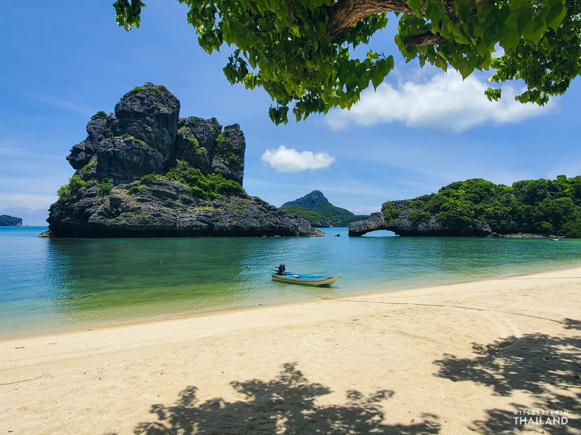
From the water, the islands appear as a long procession of green and grey limestone formations rising from a relatively shallow sea. The park is geographically close to some of Thailand’s best-known islands, but its character is completely different.
- Koh Samui
- A developed resort island with towns, roads and extensive tourism infrastructure.
- Koh Phangan
- Tourism combined with local communities and mountainous interiors.
- Mu Ko Ang Thong
- A protected archipelago. Its value lies in the relationship between the islands and the surrounding sea.
What Does “Ang Thong” Mean?
The Thai name Mu Ko Ang Thong can be understood as “the Golden Bowl Archipelago.”
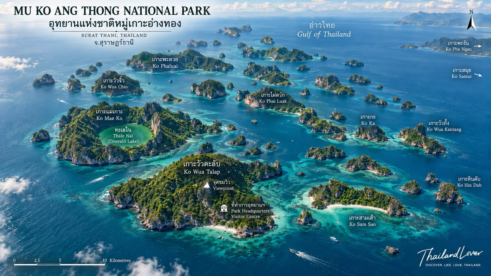
“Mu Ko” means a group or chain of islands. “Ang Thong” refers to a golden basin or bowl. The name is particularly appropriate when viewed from above: steep green mountains rising from blue water, sheltered bays opening between limestone walls, and hidden water bodies enclosed within the islands.
The landscape is less about one spectacular island than the composition of the entire archipelago.
A National Park Built Around the Sea
Unlike many terrestrial national parks in Thailand, Mu Ko Ang Thong is predominantly a marine protected landscape.
- 42 islands
- 102 km² of total protected area
- About 18 km² of terrestrial island area
- Extensive surrounding marine waters
- Coral reef, seagrass, mangrove and coastal vegetation
- Beach and limestone forest ecosystems
The relatively small amount of land compared with the total protected area is important. Mu Ko Ang Thong should not be understood as “42 islands with some surrounding sea.”
It is a marine national park in which the islands and sea function as one ecological system.
The 42 Islands
The archipelago consists of 42 islands and islets, most of them dominated by limestone geology. Among the better-known are:
- Ko Wua Ta Lap
- Ko Phaluai
- Ko Mae Ko
- Ko Sam Sao
- Ko Hin Dap
- Ko Nai Phut
- Ko Phai Luak
- Ko Wua Chio
- Ko Thai Plao
- Ko Wua Kantang
Not every island is open to visitors. A national park is not an invitation to land on every island, beach or reef within its boundary. Access is concentrated around designated locations and activities managed by the park. Many of the smaller islands remain effectively wild. That is part of the reason the archipelago still feels larger than it actually is.
The Limestone World of Ang Thong
The defining geological feature of Mu Ko Ang Thong is limestone karst. The islands rise steeply from the Gulf, producing sheer cliffs, rock pinnacles, caves, sinkholes, narrow passages, sheltered bays, rock terraces, natural arches and enclosed basins.
Over geological time, rainwater and seawater have dissolved and reshaped the rock. The result looks almost sculpted. There are few broad, flat islands here. The landscape rises sharply from sea level into forest-covered limestone hills.
The highest elevation in the archipelago is approximately 396 metres above sea level on Ko Phaluai.
Ko Wua Ta Lap
เกาะวัวตาหลับ · The Park’s Main Visitor Island
For most visitors, Ko Wua Ta Lap is the heart of Mu Ko Ang Thong. The island holds the national park headquarters and the main concentration of visitor facilities.
- Park headquarters and ranger station
- Restaurant and welfare facilities
- Accommodation and camping
- Beach in front of headquarters
- Nature trails
- Bua Bok Cave
- Pha Chan Charat Viewpoint
The beach sits directly in front of headquarters, so it is one of the easiest places in the park to combine swimming, rest and exploration. But Ko Wua Ta Lap is most famous for one thing: the view from above.
Pha Chan Charat Viewpoint
ผาจันทร์จรัส · The View That Explains Ang Thong
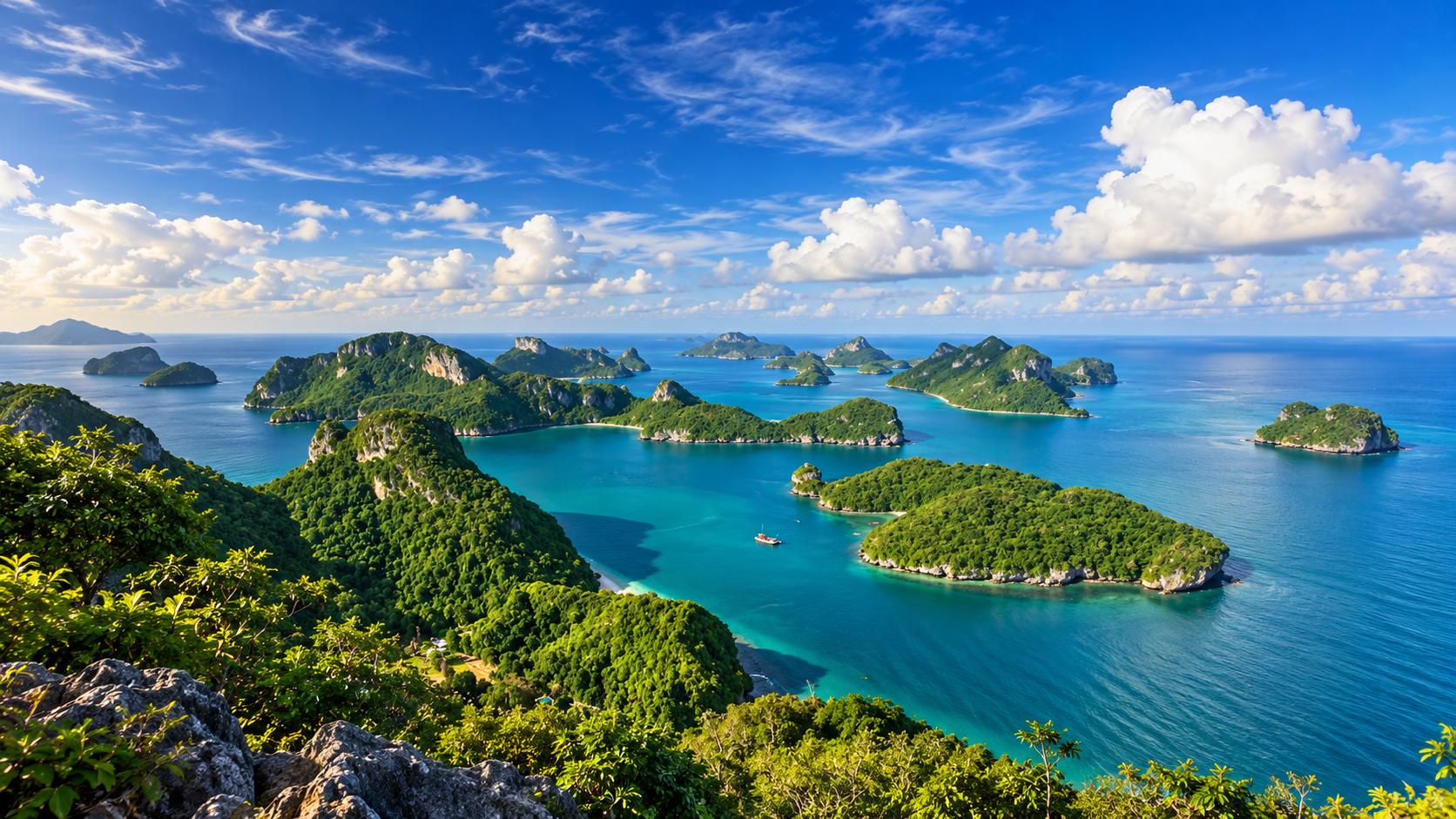
The Pha Chan Charat Viewpoint on Ko Wua Ta Lap is arguably the defining viewpoint of the park. The trail climbs through forest and limestone to an elevated lookout over the archipelago. From the top, individual islands become part of a larger composition: forest-covered limestone mountains floating in the Gulf of Thailand.
From sea level, visitors see islands. From the viewpoint, they see an archipelago. For ThailandLover, this is an essential experience.
The climb is steep in places and needs proper footwear, water and reasonable fitness. Conditions can become slippery after rain.
The viewpoint is not simply a place to take a photograph. It is where Ang Thong becomes understandable.
Bua Bok Cave
Near headquarters on Ko Wua Ta Lap is Tham Bua Bok — Bua Bok Cave. It contains limestone formations including stalactites and stalagmites. The name refers to forms within the cave associated with a blooming lotus.
The cave is another expression of the same geological processes that created Ang Thong’s cliffs, sinkholes and enclosed basins. It should not be treated as an isolated attraction. It is part of the larger limestone-karst system that defines the entire park.
Ko Mae Ko
เกาะแม่เกาะ · Home of the Emerald Lagoon
If Ko Wua Ta Lap is the visual symbol of the archipelago, Ko Mae Ko is its geological signature. Here lies Thale Nai, commonly known in English as the Emerald Lagoon or Mountain Lake.
Thale Nai is an enclosed saltwater body surrounded by limestone, formed through the development and subsidence of a limestone basin. According to established tourism and park descriptions, the lagoon is approximately:
- 250 metres wide
- 350 metres long
- Around 7 metres deep
- About 30 rai in area
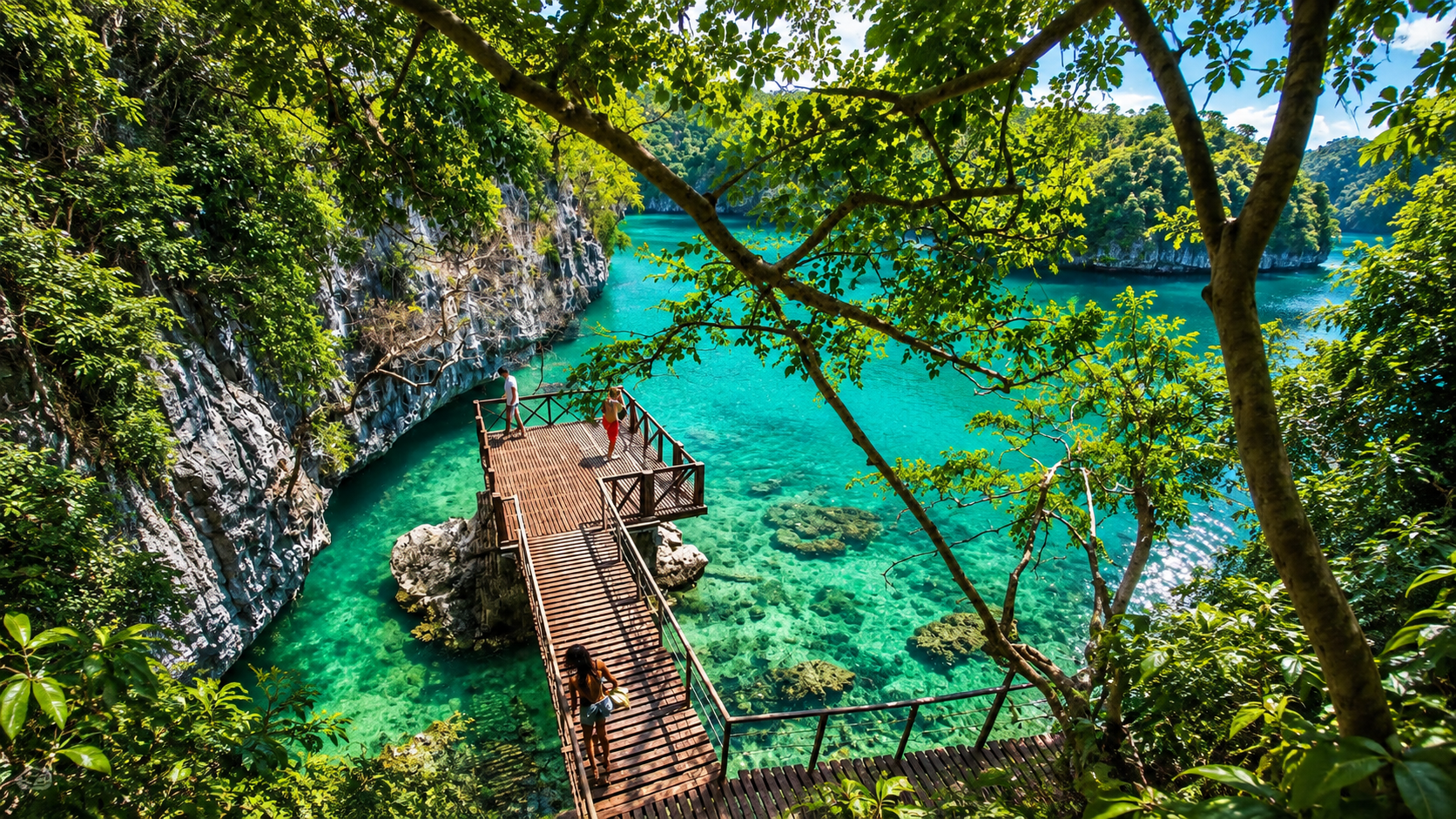
The water appears emerald green under favourable light. A viewpoint above the lagoon allows visitors to see the enclosed water on one side and the Gulf of Thailand on the other. That contrast is what makes Thale Nai extraordinary.
It is not simply a green lake. It is a saltwater landscape enclosed within a limestone island.
Thale Nai: A Geological Landscape, Not a Swimming Pool
One of the most important distinctions for responsible visitors is that Thale Nai should be treated as a geological and ecological feature, not an ordinary swimming attraction.
Visitors reach the viewpoint by boat and then walk a designated trail. The combination of limestone, enclosed water, surrounding forest and open sea creates one of the most recognisable landscapes in the Gulf of Thailand.
The Emerald Lagoon is best appreciated from the viewpoint.
Ko Sam Sao, Ko Hin Dap and the Outer Islands
Ko Sam Sao
เกาะสามเส้า · Coral, Anemones and a Natural Stone Bridge
Opposite Ko Mae Ko, Ko Sam Sao is known for its coastal landscape, coral and sea-anemone communities, and a distinctive natural stone bridge projecting towards the sea. Viewpoints reveal the geology from above. Ko Sam Sao lets visitors experience limestone formations and shallow marine ecosystems at the waterline. Surrounding waters have also been used for marine research, including studies of coral communities and juvenile coral recruitment.
Ko Thai Plao and Ko Wua Kantang
Coral and marine sightseeing
Waters around Ko Thai Plao and Ko Wua Kantang are among the locations associated with coral reef and marine sightseeing. Visibility is not guaranteed to resemble the crystal-clear conditions sometimes associated with the Andaman Sea. The western Gulf is influenced by sediment and water movement. Clarity changes with wind, rain, sea conditions, sedimentation, season and local currents.
Ang Thong is better understood as a landscape-and-marine ecosystem destination than as a destination whose primary purpose is deep-water diving.
Ko Hin Dap
เกาะหินดับ · Beach and layered rock
Ko Hin Dap is known for its attractive beach and distinctive layered rock formations. It is often described as having one of the longer beaches in the park. Thin, stacked limestone forms make the island particularly photogenic — beach and rock landscape together.
Ko Phaluai
เกาะพะลวย · The Largest Island and the Highest Point
Ko Phaluai holds the highest point in the park, approximately 396 metres. Unlike many of the smaller islands, it has a local community and a more substantial human landscape.
Mu Ko Ang Thong is not a completely uninhabited wilderness.
People have historically lived and worked within the archipelago, including through fishing, coconut cultivation and other traditional livelihoods. The relationship between local communities and the protected landscape is part of the story of Ang Thong.
Forests of Mu Ko Ang Thong
The forests are shaped by geology, shallow soils, salt spray and limited freshwater. Major habitat types include:
- Dry evergreen forest
- On the larger islands — habitat for birds, mammals, reptiles and other terrestrial wildlife.
- Limestone forest
- Specialised vegetation on slopes and cliffs, adapted to thin soils, rock crevices, strong sun, periodic drought and steep terrain.
- Beach forest
- A transition between land and sea, exposed to salt spray, wind and changing moisture.
- Mangrove
- In suitable sheltered coastal environments.
- Seagrass
- Habitat and feeding grounds in the marine ecosystem.
- Coral reef
- Shallow-water communities around parts of the archipelago.
Together these habitats give Ang Thong significance far beyond scenic value.
The Ang Thong Lady’s Slipper Orchid
One of the park’s most remarkable plants is the Ang Thong Lady’s Slipper Orchid, associated with the scientific name Paphiopedilum niveum in modern conservation references and with historical taxonomic treatment of the Ang Thong form.
It is closely associated with limestone habitats — rock crevices and suitable terrestrial environments within the archipelago. A plant restricted to a small island ecosystem shows how isolated limestone landscapes can produce specialised biological communities.
For ThailandLover, this is one of the details that turns Ang Thong from a beautiful island destination into a genuine biodiversity destination.
Wildlife of Small Islands
Terrestrial wildlife is constrained by the size and isolation of the islands. The park still supports mammals, birds, reptiles and amphibians.
Dusky Leaf Monkey
The forest’s most recognisable mammal
The dusky leaf monkey is particularly associated with the forested islands, and especially with Ko Wua Ta Lap. It is the largest commonly noted terrestrial mammal of the park. These are wild animals. They should never be fed, chased or encouraged to approach people.
Birds of Ang Thong
Cliffs, forest, beaches, mangrove and open sea create multiple feeding and nesting environments. Recorded birdlife in the broader ecosystem includes:
- White-bellied Sea Eagle
- Brahminy Kite
- Oriental Pied Hornbill
- Collared Kingfisher
- Pacific Reef Heron
- Other coastal and forest birds
For serious birdwatchers, an early morning visit is more rewarding than treating the park as a photographic stop.
Marine Wildlife, Reefs and the Coastal Connection
The marine ecosystem is one of the park’s greatest conservation values. Flagship fauna associated with Mu Ko Ang Thong in ASEAN conservation references include:
- Indo-Pacific bottlenose dolphin
- Finless porpoise
- Bryde’s whale
- Green turtle
Sightings are never guaranteed. A national park is a protected habitat, not a wildlife-show facility. Observe from a respectful distance and let the animals determine the encounter.
Coral reefs
Scientific research has documented coral communities in the park and examined juvenile coral recruitment at several locations. Shallow reef flats can function as areas of recruitment and recovery. Coral is also sensitive to rising sea temperatures, bleaching, sedimentation, physical damage, poor anchoring, marine pollution and excessive tourism pressure.
Do not stand on coral. Do not touch marine life. Do not collect shells or coral. Do not feed fish.
Seagrass, mangrove and the coast
The park should not be reduced to coral reefs. Mangroves trap sediment and provide nursery habitat. Seagrass supports food webs and shelters young organisms. Coral creates complex underwater habitat. Forests stabilise island soils. Beaches connect land and sea. The result is an ecological mosaic, not a collection of separate attractions.
Ramsar Site No. 1184 and ASEAN Heritage Park
Mu Ko Ang Thong was designated Ramsar Site No. 1184 on 14 August 2002. The Ramsar Convention identifies wetlands of international importance. In Ang Thong’s case, the recognition reflects interconnected coastal and marine ecosystems. The park is not valuable only because it is beautiful. It is internationally recognised as a wetland ecosystem of conservation importance.
In 2019, it became an ASEAN Heritage Park. That designation recognises protected areas of particularly high conservation importance and representative ecological value in Southeast Asia — limestone karst, island forests, coral, seagrass, mangroves, coastal habitats, marine biodiversity and geological uniqueness.
It is part of Southeast Asia’s regional conservation heritage.
The Human History of Ang Thong
Before becoming a national park, the islands had a human history of their own. The archipelago was historically associated with restricted areas under the Royal Thai Navy. Over time, local people established livelihoods including coconut cultivation, fishing, collection of bird nests and other coastal activities. Some islands therefore carry traces of human use alongside their natural landscapes.
A national park is not necessarily a place untouched by people. In many cases, it is a place where people, landscape and conservation have evolved together.
Kayaking, Snorkelling and Swimming
Kayaking
One of the most rewarding ways to experience the park from sea level. Depending on the route and conditions, it can reveal limestone walls, small bays, rock formations, coastal forest, sea caves, sheltered passages and beaches inaccessible by road. Strong wind, waves or currents can turn a comfortable route into a hazardous one. Follow the park and the tour operator.
Snorkelling
Generally more appropriate than expecting a major scuba-diving experience. Shallow waters and coral communities can show reef fish, corals, sea anemones and other invertebrates. Water clarity varies. A photograph taken on a particularly clear day is not a guarantee of daily visibility.
Swimming
Possible at designated beaches when conditions are safe. Waves, currents, wind and boat traffic change quickly. Swim only in appropriate areas and follow park instructions.
The Gulf decides the conditions.
Camping and Staying Overnight
Mu Ko Ang Thong is primarily a day-trip destination. Overnight accommodation and camping are available in designated areas on Ko Wua Ta Lap, subject to park rules and availability.
Staying overnight changes the experience. After the day-trip boats leave, the island becomes quieter: early light, forest sounds, a quieter beach, evening atmosphere, dawn over the Gulf, and more time for observation. For travellers who want to understand the park rather than check it off a list, an overnight stay can be particularly rewarding.
Always check availability and reservation procedures directly with the Department of National Parks before travel.
When to Visit, Hours and Fees
The most important consideration is not temperature. It is sea conditions. Strong wind and rough seas can make boat journeys uncomfortable, suspend routes, reduce snorkelling visibility, make trails slippery, or trigger temporary closures.
The park has an annual closure intended for natural recovery, maintenance and safety. Current published tourism information indicates a regular closure from 1 November to 15 December. Do not treat that as the only possible closure. Weather can close the park outside that window. In January 2026, for example, tourism activities were temporarily suspended because of strong waves and unsafe marine conditions.
Always check the latest DNP announcement before departure.
- Opening hours
- When open, published visitor information generally places hours at about 08:00–17:00. That is operating guidance, not a guarantee that every boat or attraction runs all day. Departure times depend on the operator, pier, vessel and sea.
- Entrance fees · National Park Group 2
- Thai citizens: 40 THB adult, 20 THB child. Foreign visitors: 300 THB adult, 150 THB child. These fees are separate from tour charges, boat fares and equipment rental. Verify the current rate before travel — DNP policies and exemptions can change.
How to Get There
There is no ordinary public ferry that simply drops visitors at Mu Ko Ang Thong the way the Koh Samui–Koh Phangan system works. The practical ways to visit are an organised tour, a licensed tour boat, a private charter, or a private boat arrangement subject to park rules.
Most visitors depart from Koh Samui. Common departure areas include Nathon, Bo Phut and other authorised tour piers. A speedboat reaches the park substantially faster than a larger excursion boat. The journey is part of the experience: as the developed coastline of Koh Samui falls behind, the horizon becomes limestone islands.
A typical day from Koh Samui
- Hotel transfer
- Boat departure and a scenic crossing of the Gulf
- Ko Wua Ta Lap — viewpoint or beach
- Ko Mae Ko and the Thale Nai viewpoint
- Kayaking or snorkelling
- Lunch, then return to Koh Samui
Exact routes vary. Not every tour visits every island. The name “Ang Thong National Marine Park” on an itinerary does not mean the same sequence of attractions will be included.
Not Koh Samui, Not Koh Phangan, Not Phi Phi
It is easy to think of Ang Thong as an excursion beach attached to Koh Samui. It is not. Koh Samui is a permanent island destination. Mu Ko Ang Thong is a protected archipelago managed primarily for conservation and controlled visitation. The contrast is what makes the excursion worthwhile.
Koh Phangan can also function as a gateway, but Ang Thong is not part of Koh Phangan. It is a separate national park in Ko Samui District, Surat Thani Province.
The park has sometimes been associated with The Beach, the novel by Alex Garland and the film starring Leonardo DiCaprio. The association has fed the international mythology of Thailand’s islands. The factual distinction matters: the famous film beach scenes were filmed primarily at Maya Bay on Phi Phi Leh in Krabi, not at Mu Ko Ang Thong. Ang Thong and Phi Phi are different protected landscapes in different seas. The comparison is useful only as cultural context.
Thailand’s Andaman coast is famous for limestone around Phang Nga and Krabi. Ang Thong belongs to the Gulf of Thailand. The islands are still limestone karst, but the marine environment, sediment, seasonal weather and reef character are different. Visibility is not always comparable with famous Andaman diving destinations. Ang Thong’s strongest visual asset is the relationship between land and sea — the silhouette of the archipelago.
The Best Experiences
If time is limited, ThailandLover would prioritise:
- 1. Pha Chan Charat Viewpoint
- The defining panoramic view of the entire archipelago.
- 2. Thale Nai on Ko Mae Ko
- The geological icon of Ang Thong.
- 3. Ko Wua Ta Lap Beach
- The easiest place to slow down at sea level.
- 4. Kayaking
- The best way to read the limestone coastline from the water.
- 5. Ko Sam Sao
- Coastal geology and marine scenery, including the stone bridge.
- 6. Snorkelling
- Best when sea conditions and visibility cooperate.
- 7. Bua Bok Cave
- A closer look at the limestone system.
- 8. Overnight stay
- For the park after the day-trip crowds leave.
Who Will Love Mu Ko Ang Thong?
- First-time visitors to Koh Samui
- Highly recommended. A completely different landscape from the resort beaches.
- Photographers
- Excellent. Limestone, open sea, forest and changing light — some of the strongest island panoramas in Thailand.
- Nature lovers
- Excellent. Terrestrial and marine systems in a relatively compact archipelago.
- Hikers
- Good. The viewpoints reward a short but steep and sometimes slippery climb.
- Families
- Good, if the family is comfortable with boats, heat, stairs and outdoor conditions.
- Snorkellers
- Good, with realistic expectations. Visibility is variable.
- Serious divers
- Not the strongest choice if diving is the primary purpose of the trip.
Responsible Travel
Mu Ko Ang Thong is a protected landscape. The correct visitor behaviour is simple.
- Leave the coral alone — never stand on, touch or break it
- Do not feed wildlife
- Take rubbish back — marine debris travels
- Use designated trails — limestone vegetation is fragile
- Do not collect shells, coral or plants
- Respect boat zones — never swim into boat traffic
- Follow temporary closures of trails, beaches and marine routes
A Different Kind of Island Paradise
The word “paradise” is overused in travel writing. Mu Ko Ang Thong deserves something more precise. It is a protected limestone archipelago.
The islands are not simply green. They are steep, fractured and sculpted. The sea is not simply blue. It surrounds reefs, seagrass, mangrove and shallow marine habitat. The forest is not simply tropical scenery. It supports specialised island wildlife. And the famous Emerald Lagoon is not simply a beautiful pool. It is the visible expression of a geological process.
Frequently Asked Questions
- Is Mu Ko Ang Thong National Park worth visiting?
- Yes. It is particularly worthwhile for travellers staying on Koh Samui who want a protected natural landscape rather than another resort beach.
- How many islands are in Mu Ko Ang Thong?
- The national park consists of 42 islands and islets. Not every island is open to visitors.
- Is the Emerald Lagoon freshwater?
- No. Thale Nai is a saltwater inland lagoon associated with a subsided limestone basin.
- Can you swim in the Emerald Lagoon?
- Treat it as a protected geological and ecological feature viewed from the designated viewpoint. Follow current park rules rather than assuming it is an ordinary swimming area.
- Is Mu Ko Ang Thong a Ramsar site?
- Yes. It was designated Ramsar Site No. 1184 on 14 August 2002.
- Is Mu Ko Ang Thong an ASEAN Heritage Park?
- Yes. It was designated an ASEAN Heritage Park in 2019.
- Can you stay overnight?
- Yes. Designated accommodation and camping are available on Ko Wua Ta Lap, subject to availability and current park regulations.
- Can you visit independently?
- Access is primarily by boat. Most visitors use organised tours or private charters. Independent access should follow current DNP rules and authorised boat operations.
- Is the park open all year?
- No. There is a regular annual closure, currently published as 1 November–15 December, and temporary weather-related closures can also occur.
- Is the sea always clear?
- No. Visibility changes with weather, wind, sediment and season.
- Is Ang Thong better for snorkelling or diving?
- For most visitors, snorkelling and coastal exploration are more practical than making the destination primarily about scuba diving.
- Is Mu Ko Ang Thong the same as Phi Phi?
- No. They are separate island groups in different provinces and different seas.
- Was The Beach filmed at Ang Thong?
- The famous film scenes were primarily filmed at Maya Bay on Phi Phi Leh in Krabi. Ang Thong has nevertheless been associated with the imagery of Thailand’s island landscapes.
Related Destinations
- Khao Sok National Park
- Surat Thani’s other great limestone landscape — inland rainforest and Cheow Lan, a different world from this marine archipelago.
- Than Sadet–Ko Pha-ngan National Park
- The neighbouring island park, closer to Koh Phangan’s own coast and waterfalls.
- Hat Khanom–Mu Ko Thale Tai
- Another Gulf marine park, further north, with a different island character.
- Hat Noppharat Thara–Mu Ko Phi Phi
- The Andaman limestone seascape often confused with Ang Thong in film lore. Not the same park, and not the same sea.
- Mu Ko Chang National Park
- The Gulf’s other great island park — granite rainforest, waterfalls and a much larger island, in Trat.
Location
Find Mu Ko Ang Thong National Park
Ko Wua Ta Lap, Ang Thong, Ko Samui, Surat Thani