


Marine National Park · Ranong
Mu Ko Ranong National Park
อุทยานแห่งชาติหมู่เกาะระนอง
Where Forest Meets the Andaman Sea
Ranong · Northern Andaman Coast · Southern Thailand
Rainforest, mangrove, islands, coral and seagrass — a Wet Andaman coast that still feels like a living system, not only a holiday beach.
A Coast That Still Connects
At the northern end of Thailand’s Andaman coast, one province still keeps mountain, rainforest, mangrove and sea unusually close together. That province is Ranong.
Offshore lies a chain of islands. That landscape is Mu Ko Ranong National Park — not “sea alone,” but the meeting of
Rainforest + Mangrove + Islands + Coral Reefs + Seagrass + Andaman Sea
It is more interesting as an ecosystem than as a weekend destination alone. Look deeper and the islands tell the same story as the whole province: rain, forest, water, sea, and people living between land and ocean.
The Park at a Glance
- Official Name
- Mu Ko Ranong National Park
- Thai Name
- อุทยานแห่งชาติหมู่เกาะระนอง
- Former Name
- Mu Ko Phayam National Park
- Province
- Ranong
- District
- Mueang Ranong
- Region
- Northern Andaman Coast
- Area
- About 347 km²
- Established
- 2001
- Renamed
- 23 February 2010
- Main Islands
- Ko Phayam, Ko Chang
- Other Highlights
- Ko Fai Mai, Ko Sai Dam and smaller islands
- Major Ecosystems
- Mangrove, rainforest, beaches, coral reefs, seagrass
- Biosphere Link
- Ranong Biosphere Reserve (UNESCO, 1997)
- Main Gateway
- Ranong / Pak Nam
DNP material places the park in Pak Nam, Ngao, Ko Phayam and Ratchakrut subdistricts of Mueang Ranong, stretching from the shore into the Andaman and toward the Thailand–Myanmar maritime frontier.
From Ko Phayam to Mu Ko Ranong
The park was first known as Mu Ko Phayam National Park because Ko Phayam is a signature island. The protected area always held more: Ko Chang, smaller islands, mainland coast, mangrove and marine systems.
On 23 February 2010 the name became Mu Ko Ranong National Park, to reflect that wider landscape.

A National Park Built Around the Coast
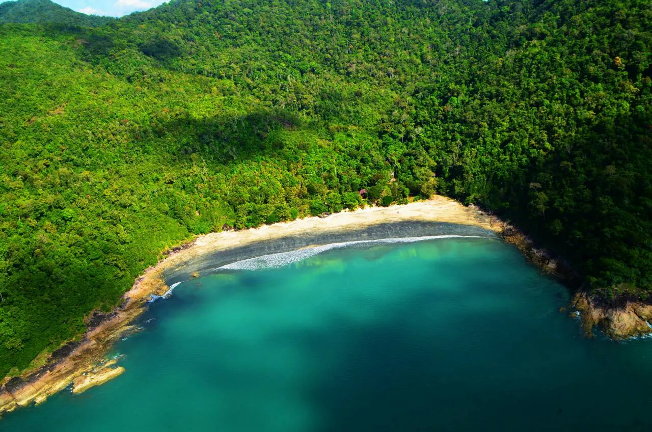
Unlike marine parks where limestone is the star, Ranong’s islands hold several landscapes together:
- Coastal mainland — the eastern edge tied to Ranong land
- Mangrove — one of the park’s defining systems
- Island forests — rainforest, beach forest and upland cover
- Beaches — sand, pebble and distinctive shores
- Coral reefs around the islands
- Seagrass meadows in coastal waters
Land → Mangrove → Seagrass → Coral → Open Sea
The Ranong Coast — Wet Andaman
Ranong is among Thailand’s wettest provinces. That humidity shapes the landscape: green mountains, streams, canals, rainforest, mangrove and sea working as one system.
So Mu Ko Ranong is not only postcard blue water. Its character is Wet Andaman — humid, green, with forest close to the sea.
The Mangrove Kingdom
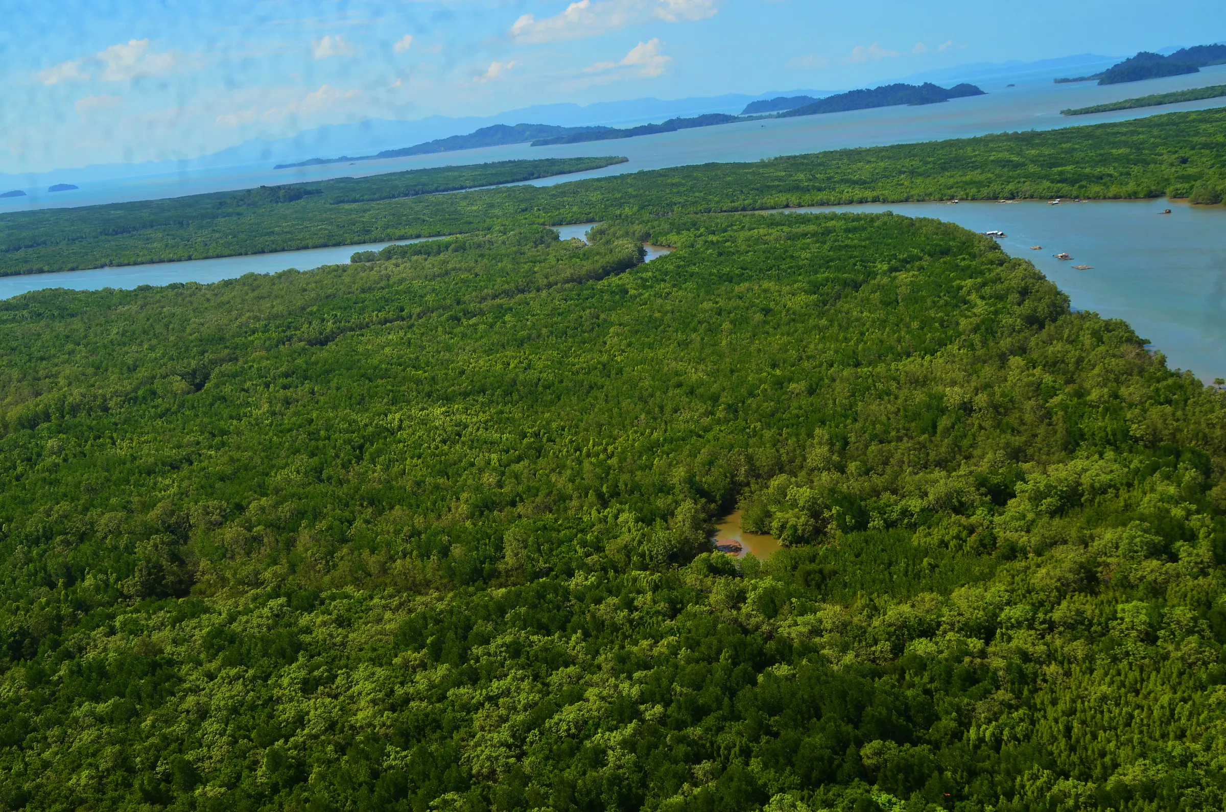
If one ecosystem must explain the park, it is mangrove. Ranong’s coastal mangrove has international weight and helped the coast become a UNESCO Ranong Biosphere Reserve in 1997 — notable for mangrove as a core element.
The biosphere covers about 190,782.10 rai in core, buffer, transition and marine zones. Part of that reserve overlaps Mu Ko Ranong. DMCR figures note about 64,572 rai of marine area within the biosphere numbers.
Mangrove is coastal infrastructure: roots hold sediment, dampen waves, shelter young fish, feed wildlife, host birds and link land to sea. Passing by boat, you are not only seeing trees — you are seeing one of the most productive coastal ecosystems on Earth.
Ko Phayam
เกาะพยาม · The island that put Ranong on the map
Ko Phayam sits about 33 km offshore, roughly 34.7 km², in Ko Phayam Subdistrict. Forest, beach, village, gardens and local livelihoods share the island.
It is not a mass-tourism megadestination: no big through-roads, no high-rises, smaller-scale tourism. The picture is beach + forest + village + small resorts + local life.
Ao Yai
อ่าวใหญ่
One of Phayam’s best-known western beaches — open shore toward the Andaman, strong for sunset, and a reminder that large coastal stretches still connect to the island’s nature.
Ao Khao Kwai
อ่าวเขาควาย
Named for the bay’s landform. Beach and forest; quieter than large resort strands. DMCR material also notes a Moken / sea people community near this bay — present carefully, without collapsing every island story into one ethnicity.
Phayam is not tourism alone: fishing, farming, gardens, small services and small business remain part of daily life.
Ko Chang
เกาะช้าง · The forested island
Ranong’s Ko Chang has a different character from Phayam. Island databases give about 20.2 km²; fisheries sources about 18.19 km² — methods differ. ThailandLover prefers approximately 18–20 km² in travel writing, not a hard headline figure.
If Phayam is beaches and community, Ko Chang is forest and quiet: mountain cover, smaller settlements, a slower island for travellers who want less noise.
Ko Fai Mai and Ko Sai Dam
Ko Fai Mai
เกาะไฟไหม้ · Pebble beach island
A small island near the Ko Chang line, known for a pebble beach of rounded, multi-coloured stones that catch light differently than sand. Government tourism notes rainforest cover on the island.
Ko Sai Dam
เกาะทรายดำ · Black sand and community
Famous for a black sand beach from dark sediments and organic coastal deposits. Close up, colours mix; the overall darkness comes from a high share of dark material — not marketing “100% pure black sand.”
A community older than a century still lives with coastal fishing: nets, shrimp paste (กะปิ), local catch and community tourism. A clear nature + community + culture place.
Laem Makham and Ao Po
Laem Makham offers about 4 km of mangrove nature trail — canals, intertidal ground, mangrove plants and coastal wildlife. Built for nature interpretation, not only photos.
Ao Po, south of Ko Sai Dam, is a quieter bay with strong mangrove scenery, linked to community tourism and homestays — nature and local food in one place.
Coral, Seagrass and Marine Life
Reefs surround the islands, but condition changes over time — temperature, sediment, water quality, storms, human activity and warming all matter. A 2024 survey around Ko Phayam found reefs generally in good condition, with boulder and encrusting coral groups prominent.
Seagrass is the other underwater meadow. DMCR surveys in 2026 covered potential areas around Ko Phayam, Ko Chang and Pak Khlong Bang Chak totalling more than 743 rai. A 2025 Phayam survey found about 33 rai and at least nine species, including Halophila ovalis, H. minor, H. decipiens, Cymodocea rotundata, Oceana serrulata, Halodule uninervis, H. pinifolia, Enhalus acoroides and H. major, with H. decipiens and H. pinifolia among the common finds.
Seagrass is feeding ground, nursery and shelter — and links to rare marine mammals such as dugongs. ThailandLover says the ecosystem supports marine life, including feeding habitat for dugongs — not a promise of sightings.
Birds, Forest and Rain
Mangrove and islands hold shorebirds, waterbirds, seabirds, forest birds, residents and migrants. For birdwatchers, Ranong’s mangrove coast is an overlooked destination.
Many islands are not beach alone. Ko Chang especially holds mountain rainforest. High humidity gives a tropical rainforest island feel — dense canopy, streams, epiphytes.
To understand Ranong, understand rain: long wet seasons keep the green — and mean travel planning must weigh weather + sea conditions, not only “tourist season.”
A Park Between Two Worlds
One side is mainland Thailand; the other the Andaman, and beyond it Myanmar. Nature, shipping, fishing and coastal history meet here.
DNP history notes that in the past Phraya Damrong Sucharit Mahitsornphakdi (Koh Su Chiang), then governor of Ranong, settled a Thai Muslim community under “Pa Hoi” on Ko Phayam as part of guarding against British encroachment when Britain held power in Burma. Traces of that story are still mentioned at Laem Farang near Ao Yai.
A sea that looks like rest once worked as a strategic frontier.
Conservation Today
Seagrass surveys and monitoring show conservation is not finished — it is measured and adjusted. A 2025 ministry measure for the Phayam islands covers beaches, coral, soft coral, seagrass, reef life and rare marine animals.
Enjoy the ecosystem without becoming part of the disturbance.
Things to Do
- 01 — Island hopping
- Phayam → Chang → smaller islands — each a different character.
- 02 — Beach walking
- Sand, forest edge and tide as the storyteller.
- 03 — Snorkelling
- When the sea allows; never stand on coral.
- 04 — Kayaking
- Mangrove and permitted coasts from water level.
- 05 — Laem Makham
- Mangrove interpretation on the nature trail.
- 06 — Birdwatching
- Morning along mangrove, mudflat and forest edge.
- 07 — Photography
- Boats, channels, black sand, forest, sunset, villages, tidal ground — documentary more than postcard.
- 08 — Community tourism
- Especially Ko Sai Dam: fishing, food and mangrove life with depth.
When to Visit
Island access follows monsoon and park notices. Check waves, rain, boat schedules, beach conditions, closures and sea safety before travel.
Government tourism information has listed annual closures for Ko Chang and Ao Khai Tao from 16 May–14 October. Dates can change by year.
Always check the latest park announcement.
How to Get There
From Bangkok: south on Phet Kasem — Bangkok → Chumphon → Ranong — then to a pier for the islands.
By air: Ranong Airport, then into town and the coast. From Ranong town continue toward Pak Nam and island boats.
Boat times to Ko Phayam vary by vessel and sea — check the current schedule. Ko Chang has fewer services; plan ahead, especially in rough weather or seasonal closures.
Responsible Travel
- Carry rubbish out; cut single-use plastic
- Use community services; stay on marked routes
- Respect mangrove; keep distance from wildlife
- Do not touch coral or walk on seagrass
- Do not take rocks or living things; do not feed or chase animals
- No anchors on reef; no entry to closed zones
- Check park notices; support local operators
Bring reef-aware sunscreen, rain layer, mosquito protection, dry bag and binoculars if birdwatching. Rain can rewrite plans quickly — flexibility is part of the trip.
Frequently Asked Questions
- Is Mu Ko Ranong the same as Ko Phayam?
- No. Phayam is a key island inside a wider park of coast, other islands and marine systems.
- Is all of Ko Phayam national park?
- No. The island mixes conservation, community and other uses.
- When was it renamed?
- From Mu Ko Phayam to Mu Ko Ranong on 23 February 2010 (established 2001).
- Is Ko Sai Dam really black?
- Yes in overall tone — from dark sediments and organic material, not every grain pure black.
- Can I see dugongs?
- Seagrass supports dugong feeding habitat. Sightings are not guaranteed.
- Open all year?
- Not every area. Ko Chang and Ao Khai Tao have been listed closed 16 May–14 October — confirm current notices.
Related Destinations
- Laem Son National Park
- Ranong–Phang Nga mangrove and quiet Andaman beaches.
- Mu Ko Ra–Ko Phra Thong
- Further south — Andaman savannah, wetland and quiet islands.
- Mu Ko Surin National Park
- Offshore Andaman reefs and islands of Phang Nga.
- Lam Nam Kra Buri National Park
- River and forest inland toward the same northern Andaman belt.
- Mu Ko Phetra National Park
- Limestone islands of Satun and Trang further down the coast.
Location
Find Mu Ko Ranong National Park
Mueang Ranong / Pak Nam · Ko Phayam, Ranong