

National Park · Prachuap Khiri Khan
Khao Sam Roi Yot National Park
อุทยานแห่งชาติเขาสามร้อยยอด
Where Mountains Meet the Sea
Prachuap Khiri Khan · Kui Buri · Sam Roi Yot · Gulf of Thailand
Discover a landscape unlike anywhere else in Thailand — hundreds of limestone peaks rising above wetlands, caves, beaches and the Gulf of Thailand.
A Landscape Like Nowhere Else
There are national parks defined by mountains. There are national parks defined by the sea. And then there is Khao Sam Roi Yot — where dramatic limestone peaks rise directly beside wetlands, beaches, caves and the Gulf of Thailand.
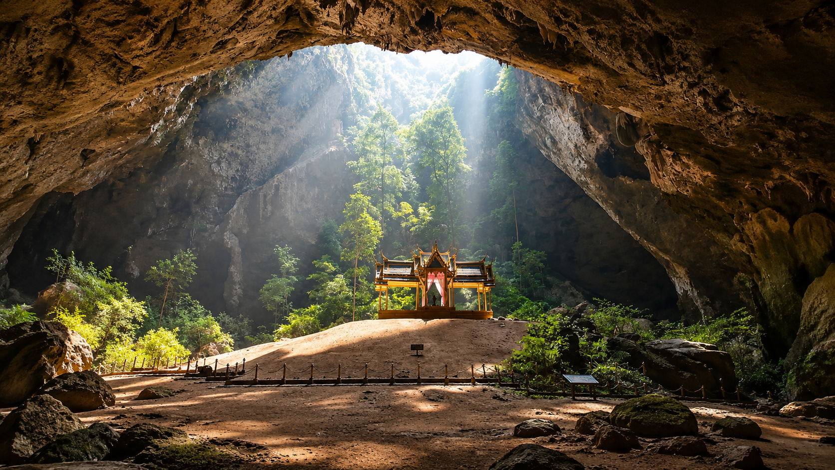
Just south of Hua Hin lies one of Thailand’s most remarkable protected landscapes: a world of karst mountains, freshwater marsh, migratory birds, hidden caves, quiet beaches and the legendary Phraya Nakhon Cave, where a royal pavilion stands beneath a shaft of natural light.
Located in Prachuap Khiri Khan Province, about 60 kilometres south of Hua Hin, the park protects limestone mountains, freshwater marshes, coastal plains, beaches, mangroves, caves and offshore limestone islands. It was established on 28 June 1966 as Thailand’s 4th national park — and historically as Thailand’s first marine national park.
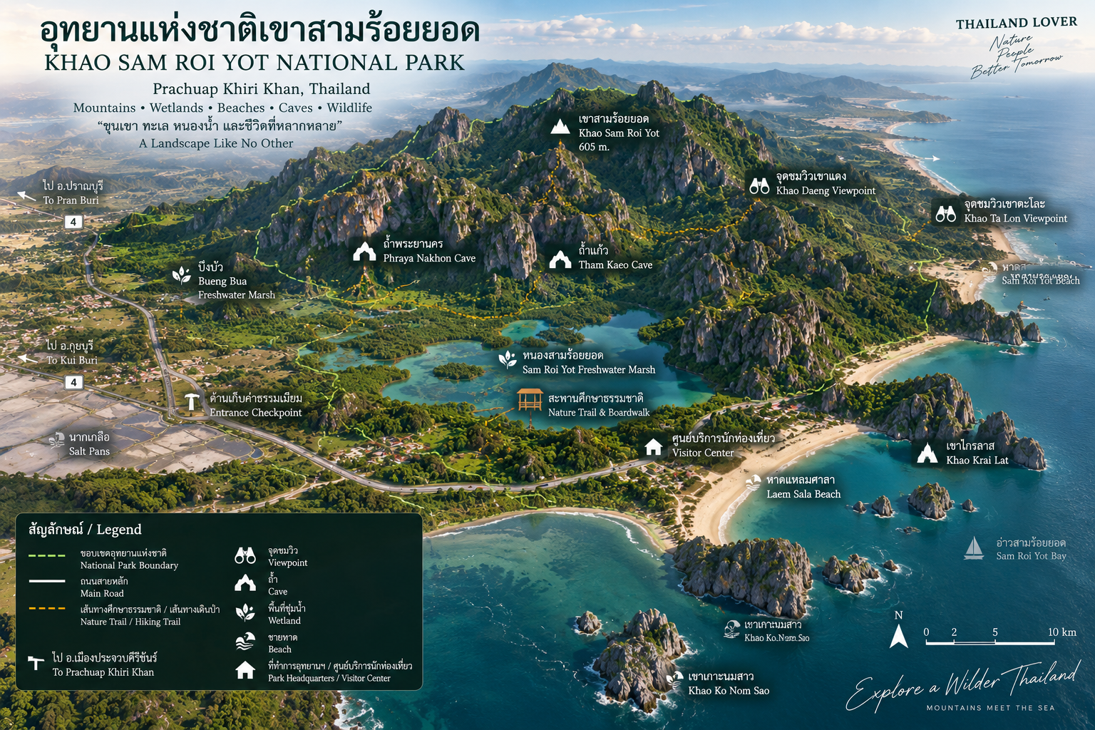
The park covers approximately 98.08 km², or around 61,300 rai. Older records describe the original nationally protected area as about 61.28 km² before later boundary changes. Roughly 20% is marine. The land holds limestone peaks, caves and extensive freshwater wetlands. At its highest point, Khao Sam Roi Yot rises to about 605 metres.
The mountain itself is only part of the story. The real magic is the relationship between ecosystems — a standout in ThailandLover’s Nature & Parks collection.
Mountain → Wetland → Forest → Cave → Beach → Sea.
At a Glance
- Official Name
- Khao Sam Roi Yot National Park
- Thai Name
- อุทยานแห่งชาติเขาสามร้อยยอด
- Province
- Prachuap Khiri Khan
- Districts
- Kui Buri & Sam Roi Yot
- Area
- Approx. 98.08 km² / 61,300 rai
- Highest Peak
- Khao Sam Roi Yot — approx. 605 m
- Established
- 28 June 1966
- National Park No.
- 4th national park of Thailand
- Special Status
- Thailand’s first marine national park
- Mountain Type
- Limestone / karst
- Major Wetland
- Thung Sam Roi Yot · Bueng Bua
- Signature Cave
- Phraya Nakhon Cave
- Historic Pavilion
- Khuha Kharuehat Pavilion (1890)
- Signature Viewpoint
- Khao Daeng Viewpoint
- Major Waterway
- Khao Daeng Canal
- Major Beaches
- Laem Sala Beach · Sam Phraya Beach
- Other Caves
- Kaew Cave · Sai Cave
- Wildlife Highlight
- Wetland and migratory birds — ~300 recorded species
- Landscape
- Mountains · Wetlands · Caves · Beaches · Islands · Mangroves
- Nearest Hub
- Hua Hin — about 60 km north
Why Is It Called “Sam Roi Yot”?
The Mountain of Three Hundred Peaks
Khao Sam Roi Yot literally evokes a mountain with three hundred peaks. The name reflects the unusual limestone landscape, where sharp and rounded summits rise closely together.
There are also traditional legends. One local story tells of a Chinese junk caught in a storm, wrecked among the rocks. Survivors supposedly reached the islands — about 300 people — giving rise to an older name interpreted as “Ko Sam Roi Rot,” the island of three hundred survivors, later associated with Sam Roi Yot.
Another explanation is simpler: the area contains an extraordinary number of limestone peaks, appearing almost like hundreds of individual summits. These are local traditions, not geological explanations of how the mountain formed. Thailand’s Office of Natural Resources and Environmental Policy and Planning records both versions of the naming tradition.
A Sea of Limestone
Khao Sam Roi Yot is one of Thailand’s most distinctive karst landscapes. Karst develops where soluble rock — especially limestone — is gradually dissolved by water over geological time. The result can include towers, cliffs, caves, sinkholes, underground drainage, isolated peaks and steep limestone walls.
The Department of Mineral Resources identifies the park as an important geological site because of this topography. Look at the mountains from a distance and the name suddenly makes sense. Instead of one continuous ridge, the landscape appears filled with countless limestone forms rising independently from the plains.
605 metres above the sea
The highest point is approximately Khao Sam Roi Yot — 605 metres. It is not a giant mountain by Thai standards. Its significance comes from shape and setting. The limestone peaks rise dramatically from relatively low coastal plains, creating an extraordinary vertical contrast.
Wetland below → forest → limestone cliffs → 605-metre peaks → sky → Gulf of Thailand.
The landscape is compact, but visually enormous.
Thung Sam Roi Yot
ทุ่งสามร้อยยอด · The Wetland at the Heart of the Park
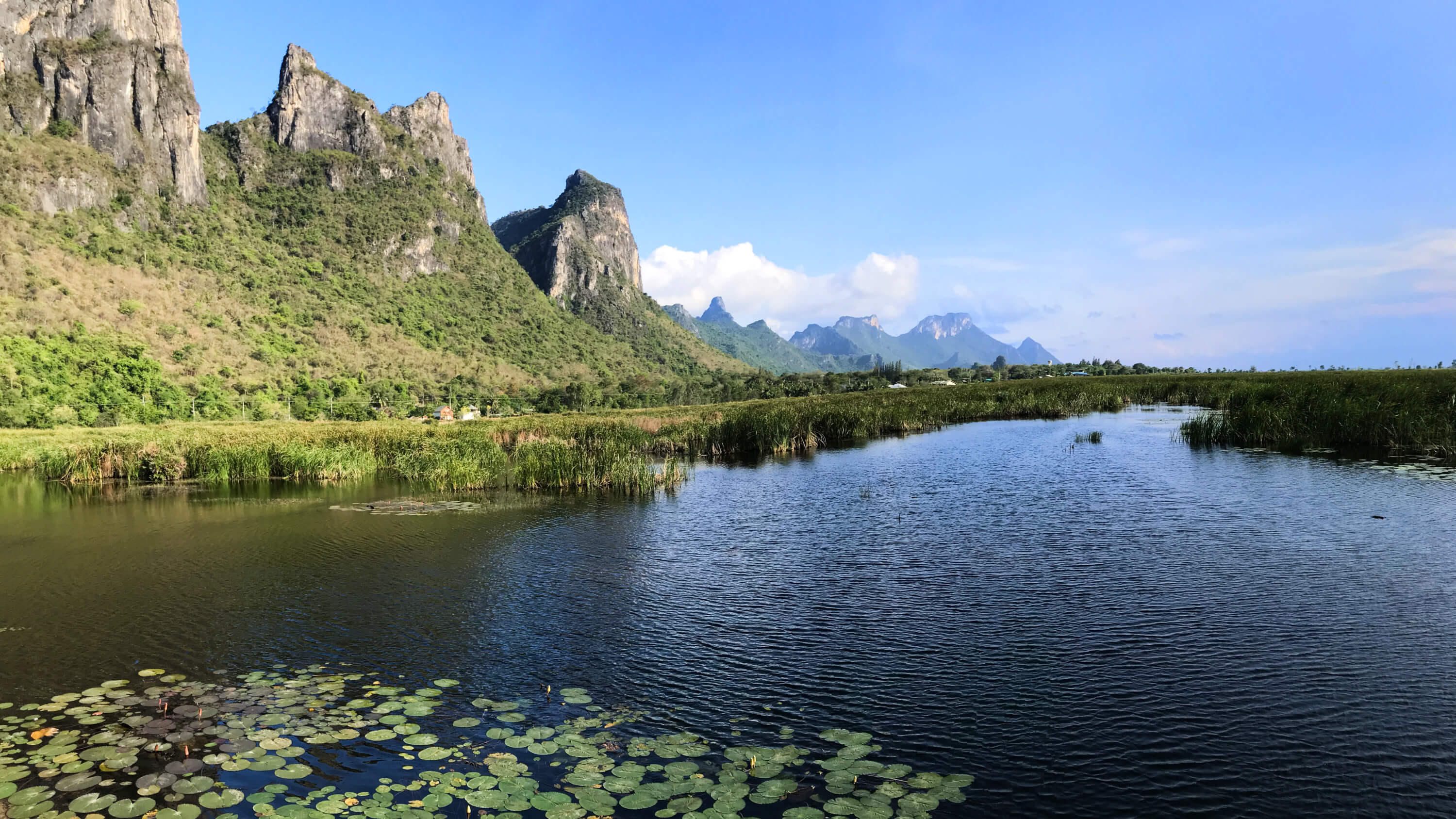
If Phraya Nakhon Cave is the park’s most famous cultural-natural landmark, Thung Sam Roi Yot is arguably its most important ecological feature. The wetland occupies a huge area between the limestone mountains and the coast. It is primarily a freshwater marsh, surrounded by the dramatic limestone range.
The Department of Mineral Resources describes the Sam Roi Yot marsh as covering approximately one-third of the park, supporting rich aquatic vegetation and about 300 recorded bird species.
This is not simply a mountain park. It is also a wetland park.
Bueng Bua
บึงบัว · The Most Peaceful Side of Sam Roi Yot
Inside the Thung Sam Roi Yot wetland is Bueng Bua, a freshwater marsh that has become one of the park’s most recognisable nature experiences. A wooden nature-study boardwalk extends into the wetland, allowing visitors to experience the marsh without disturbing the habitat.
The scene is remarkably simple: water, lotus, reeds, birds, mountains, sky. The mountains surround the wetland like a natural amphitheatre. Thailand Tourism Directory describes Bueng Bua as a large freshwater wetland surrounded by the Sam Roi Yot range, with a wooden walkway extending into the marsh.
Bird Paradise
Where the East Asian–Australasian Flyway Meets Thailand
Khao Sam Roi Yot is one of Thailand’s important birdwatching destinations. The wetland lies along the East Asian–Australasian Flyway, one of the world’s major migratory bird routes. The park is valuable not only for resident birds but also for migratory species using wetlands and coastal habitats during their annual movements.
Habitats include freshwater marsh, reed beds, mangroves, mudflats, coastal forest, limestone forest and open agricultural land surrounding the protected area.
Look down into the wetland
At Bueng Bua, the mountains create a dramatic background. But the real action is often much smaller. Look into the reeds. Watch the water. Listen for calls. Then look toward the sky.
Depending on season and conditions, birdwatchers may encounter herons, egrets, kingfishers, waders, rails, waterhens, shorebirds, raptors and migratory species.
A visitor rushing through Khao Sam Roi Yot sees the mountains. A birdwatcher sees an ecosystem.
Phraya Nakhon Cave
ถ้ำพระยานคร · The Icon of Khao Sam Roi Yot
There is a reason Phraya Nakhon Cave is one of Thailand’s most recognisable natural landmarks. Inside a vast limestone chamber, sunlight enters through a collapsed section of the cave roof. Beneath that opening stands the elegant Khuha Kharuehat Pavilion.
A royal pavilion. Inside a cave. Surrounded by limestone formations. Illuminated by a shaft of natural sunlight. It is not an artificial tourist attraction. It is a structure placed inside a naturally formed geological cathedral.
The cave is part of the experience
Reaching Phraya Nakhon requires effort. Visitors traditionally approach through Laem Sala Beach, then follow a steep forest-and-limestone trail into the mountain. The walk is not extremely long for a fit traveller, but it includes steep sections and uneven terrain.
Phraya Nakhon is not a roadside attraction. You have to earn the view. The trail climbs through limestone forest. The coast gradually disappears. The sound of the sea becomes distant. Then the cave entrance appears — and the landscape opens into darkness.
Two chambers
The cave consists essentially of a large system with two major chambers. The first is darker and more enclosed. The second contains the famous opening in the roof. When sunlight enters, it creates the visual effect that made the cave internationally famous.
TAT describes the cave as having two chambers, with the royal pavilion built in 1890 illuminated by sunlight entering through the natural opening.
Khuha Kharuehat Pavilion
พระที่นั่งคูหาคฤหาสน์ · Built for King Rama V
The pavilion was constructed in 1890 for the visit of King Chulalongkorn (Rama V). It has since become one of the defining symbols of Prachuap Khiri Khan Province — architecture made striking by its location, standing beneath the enormous natural opening of the cave.
When sunlight falls through the opening, the pavilion appears almost theatrical. But nothing about the setting was designed by an architect. The mountain created the stage.
The golden light
The famous photograph is usually taken when sunlight reaches the pavilion. The exact appearance changes with season, time of day, weather, sunlight angle and atmospheric conditions. The light can transform the cave from a dark underground space into a dramatic natural cathedral.
That is why arriving at the right time matters — and why the experience can never be fully reproduced by a photograph.
A Cave Painted 3,000 Years Ago
Phraya Nakhon is not the only cave with historical significance. In 2020, archaeologists announced the discovery of approximately 3,000-year-old cave paintings in one of the park’s caves. TAT reported the discovery as evidence of prehistoric human activity in the area.
This adds another chronological layer. Long before national parks, modern tourism, roads or royal visits, people were already using these caves and mountain environments.
Kaew Cave & Sai Cave
- Kaew Cave · ถ้ำแก้ว
- Also written Tham Kaeo. Unlike Phraya Nakhon, its identity is less about a single architectural landmark and more about the cave environment itself: stalactites, stalagmites, rock chambers, narrow passages and unusual limestone formations. Phraya Nakhon shows cave + architecture + sunlight. Kaew Cave reveals cave + geology + darkness.
- Sai Cave · ถ้ำไทร
- Another part of the park’s limestone cave network — another chance to explore the geological character of the Sam Roi Yot mountains. Treat caves as natural environments, not conventional tourist buildings. Conditions can include darkness, slippery rock, uneven terrain, bats and fragile formations. Follow park guidance and avoid touching cave formations.
Khao Daeng Viewpoint
จุดชมวิวเขาแดง · The View That Explains the Park
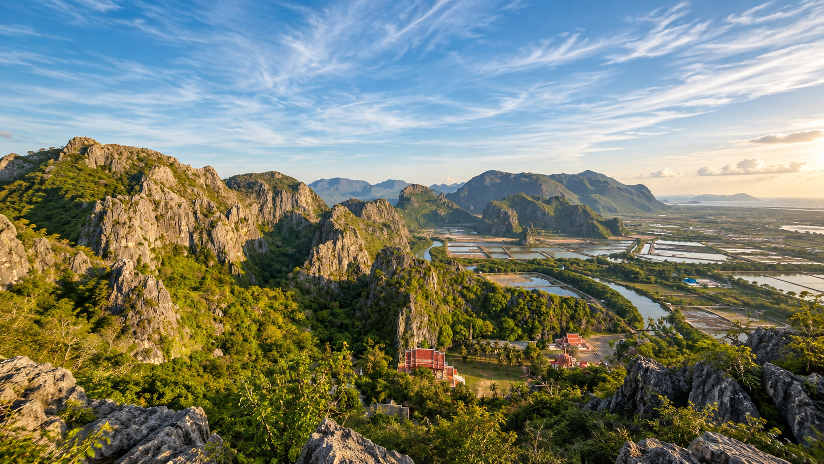
If Bueng Bua shows the wetland from ground level and Phraya Nakhon reveals the mountain from inside, Khao Daeng Viewpoint reveals the entire landscape from above: limestone peaks, mangroves, wetlands, coastal plains, villages, waterways and the Gulf of Thailand.
It is one of the best places to understand why Khao Sam Roi Yot is so unusual. You can see multiple ecosystems at once. TAT identifies Khao Daeng Viewpoint as one of the park’s three principal visitor highlights, alongside Phraya Nakhon Cave and the wetland environment.
Khao Daeng Canal
คลองเขาแดง · Through the Mangrove
The canal passes through a coastal wetland and mangrove environment beneath the limestone mountains. A boat journey reveals the park from a completely different perspective. Instead of climbing the mountain, you move horizontally through the wetland. Instead of looking down from a viewpoint, you look upward. The limestone cliffs rise above the mangroves — one of the most distinctive landscapes in coastal Thailand.
The mangrove
Mangrove habitat forms a transition between freshwater, brackish water, seawater and land. Mangroves provide nursery habitat for fish, shelter for crustaceans, habitat for birds, sediment retention, coastal protection and carbon storage. Khao Sam Roi Yot’s mangrove and wetland systems therefore have ecological value far beyond their appearance.
Laem Sala & Sam Phraya
- Laem Sala Beach · หาดแหลมศาลา
- One of the park’s most beautiful coastal areas: a relatively secluded beach backed immediately by limestone mountains, and the traditional gateway to the Phraya Nakhon Cave trail. The visual sequence is extraordinary — sea → beach → forest → limestone mountain → cave. TAT notes that accommodation and camping facilities have historically been available around Laem Sala, subject to current park operations.
- Sam Phraya Beach · หาดสามพระยา
- Backed by forest and limestone mountains, with a very different atmosphere from the heavily developed beaches around Hua Hin. A place for walking, photography, watching sunrise, observing coastal vegetation and quiet relaxation. Thailand’s tourism directory identifies Sam Phraya among the park’s principal attractions.
Khao Sam Roi Yot is unusual because the mountains do not sit far inland. They come remarkably close to the Gulf. That produces a compressed landscape in which limestone cliffs can be seen beside wetlands, beside beaches, beside the open Gulf of Thailand. That is the geographical signature of the park.
Offshore Limestone Islands
The limestone geology does not stop at the shoreline. The offshore environment includes several small limestone islands and rock formations. The Department of Mineral Resources identifies examples including Ko Sattakut, Ko Nom Sao, Ko Rawing, Ko Rawang and Ko Khi Nok as extensions of the limestone landscape offshore. These islands show that the same geological system continues beneath and beyond the coastal waters.
Thailand’s First Marine National Park
When it was established on 28 June 1966, Khao Sam Roi Yot became Thailand’s 4th national park — and Thailand’s first marine national park. That was a landmark moment. The concept of a national park was being expanded beyond mountains and forests to include coastal and marine environments.
Before becoming a national park, the area had already been recognised for its natural value. In 1962, approximately 99.50 km² of the Khao Sam Roi Yot forest was designated as a forest reserve. The area contained valuable tree species and remarkable scenery considered worthy of protection. Four years later, the protected landscape became the fourth national park.
Forest protection → national park → coastal protection → marine conservation.
Not One Forest, but Many Habitats
The park’s terrestrial environment contains different vegetation communities according to elevation, moisture, soil, exposure, proximity to the sea and proximity to wetlands. The result is unusually high habitat diversity within a relatively small national park.
- Limestone forest
- Found around the rugged karst mountains.
- Dry forest
- Adapted to pronounced seasonal dryness.
- Coastal forest
- Associated with beaches and coastal plains.
- Mangrove
- Found around tidal waterways.
- Wetland vegetation
- Found around Thung Sam Roi Yot.
The wetland–mountain connection
The most interesting thing about Khao Sam Roi Yot is not any single attraction. It is the relationship between its ecosystems. Rain falls on the mountains. Water flows downward. It collects in wetlands. Wetlands connect with waterways. Mangroves filter coastal water. The coast meets the Gulf. And limestone mountains stand over everything.
Mountain → Water → Wetland → Mangrove → Sea.
Wildlife & the Flyway
The combination of wetland, mountain, forest and coast creates habitats for a wide range of wildlife. Reported wildlife includes dusky langur, long-tailed macaque, barking deer, wild boar, various bats, squirrels, reptiles, amphibians, freshwater species and coastal and marine species. The wetland is particularly important for birds. This is why Khao Sam Roi Yot is much more than a sightseeing destination. It is an ecological crossroads.
The East Asian–Australasian Flyway stretches across a huge portion of Asia and the Pacific. Migratory birds travel thousands of kilometres between breeding and wintering grounds. Wetlands such as Thung Sam Roi Yot provide food, resting areas, shelter, freshwater and shallow feeding habitat. For serious birdwatchers, the park is valuable at an international ecological scale.
When to watch birds
The wetland comes alive before the heat of the day. Arrive early. Move slowly. Keep quiet. Watch the reeds. Scan the water. Look toward the sky. The mountains provide the backdrop. The wetland provides the life.
The Gulf from Every Elevation
Khao Sam Roi Yot is unusual because you can experience the Gulf from multiple elevations. From the beach, the sea is immediate. From the wetland, it is part of a larger water system. From Khao Daeng, the coast becomes a geographical pattern. From the mountain, the Gulf becomes a distant horizon. Few national parks offer this many perspectives within such a compact area.
Fishing, Farming and Salt
The national park does not exist in isolation from local communities. Around its boundaries are villages, agricultural land, fishing communities, salt-production areas, roads, canals and aquaculture. This creates a complex interface between protected nature and human livelihood. The conservation story is not simply about keeping people out. It is about maintaining ecological functions while living alongside communities.
Around the coastal plain, visitors can encounter traditional salt production. The open salt pans create a surprisingly geometric landscape: white salt, shallow water, mud, blue sky, limestone mountains. It is another example of how human activity and the natural landscape coexist around Sam Roi Yot.
From ground level, individual limestone mountains can appear isolated. From above, the landscape becomes clearer: a complex karst network, wetlands in the lowlands between them, the coast curving around the eastern edge, small islands continuing the limestone formation offshore. A bird’s-eye view reveals the architecture of the landscape.
One National Park — Many Worlds
- Mountain
- Khao Sam Roi Yot — 605 metres of limestone landscape.
- Wetland
- Thung Sam Roi Yot / Bueng Bua — a major freshwater ecosystem.
- Cave
- Phraya Nakhon — a natural chamber containing a royal pavilion.
- Viewpoint
- Khao Daeng — mountains, wetlands and sea from above.
- Canal
- Khao Daeng Canal — mangroves and coastal waterways.
- Beach
- Laem Sala — the gateway to Phraya Nakhon. Sam Phraya — a quieter coastal landscape.
- Caves
- Kaew Cave and Sai Cave — the geological side of the karst landscape.
A Perfect Day in Khao Sam Roi Yot
- 05:30 — The wetland
- Begin at Bueng Bua. The light is soft. Birds are active. Mist may still sit around the mountains.
- 07:30 — Breakfast
- Leave the wetland and take time for breakfast around the local communities.
- 09:00 — Phraya Nakhon
- Head toward Laem Sala. Walk the coastal trail. Climb into the forest. Enter the cave. Wait for the light.
- 12:00 — Laem Sala
- Return toward the beach. Rest. Eat. Listen to the sea.
- 15:00 — Khao Daeng
- Take the viewpoint trail. Look across the entire landscape.
- 17:00 — Khao Daeng Canal
- If operating, experience the canal and mangrove landscape.
- 18:00 — Sunset
- Return toward the coast. Watch the mountains change colour.
- Night
- If permitted and conditions are suitable, look up. The park’s relatively dark environment can offer excellent opportunities for observing the night sky.
When to Visit
- The wet season
- After rain, waterfalls become more active, vegetation greener, wetlands expand, mountains become atmospheric and clouds gather around the limestone peaks. Trails can also become slippery.
- The dry season
- Skies are often clearer, viewpoints can have greater visibility, trails may be easier, wetlands can change character, and birding conditions vary seasonally. For migratory birds, timing matters considerably.
The park is therefore not simply a “best month” destination. Different seasons reveal different versions of Khao Sam Roi Yot.
The best time for photography
- Sunrise
- Bueng Bua, wetlands, mountains, reflections, birds.
- Morning
- Phraya Nakhon Cave, soft light, forest, cave photography.
- Late afternoon
- Khao Daeng, limestone cliffs, coastal landscapes.
- Sunset
- Beaches, limestone silhouettes, warm colour.
- Night
- Stars, Milky Way photography, dark-sky experiences — when permitted.
Responsible Travel
The wetland is fragile. The caves are fragile. The limestone ecosystem is fragile. The archaeological heritage is irreplaceable.
Do
- Stay on designated trails
- Follow park regulations
- Keep noise low
- Use designated boardwalks
- Carry rubbish out
- Respect birds and wildlife
- Bring binoculars for birdwatching
- Avoid disturbing nesting or feeding areas
- Follow instructions around caves
- Protect archaeological structures
- Use environmentally responsible products near marine areas
Do not
- Feed wildlife
- Touch bats
- Collect shells, rocks or cave formations
- Touch stalactites or stalagmites
- Climb archaeological structures
- Leave plastic in the wetland
- Fly drones where prohibited
- Disturb birds
- Enter closed caves
- Swim in unsafe conditions
Safety
Khao Sam Roi Yot combines several environments, each with its own risks.
- Mountain
- Steep trails.
- Cave
- Darkness and slippery rock.
- Wetland
- Deep or muddy areas away from boardwalks.
- Sea
- Currents and changing weather.
- Wildlife
- Animals should never be approached.
The most important rule is simple: follow current park instructions rather than relying on old travel information.
Khao Sam Roi Yot & Hua Hin
The park is about 60 kilometres south of Hua Hin, making it one of the easiest major national parks to combine with a Hua Hin itinerary. Close enough for a day trip — different enough to feel like another world.
- Hua Hin
- Beach resort. Restaurants. Hotels. Golf. Urban coast.
- Khao Sam Roi Yot
- Wetlands. Birds. Caves. Limestone mountains. Mangroves. Forest.
The park provides an immediate transition from resort tourism to protected nature.
Getting There
- From Hua Hin
- A common route follows Highway 4 / Phetchakasem Road southward before turning toward the park. Provincial tourism information describes access from Hua Hin via Highway 4 and routes toward headquarters, with the approach from Phetchakasem being roughly 37 kilometres depending on the entry route.
- From Bangkok
- Approximately 255 kilometres by road, depending on the route and starting point. For international visitors staying in Hua Hin, Khao Sam Roi Yot is one of the more accessible major protected landscapes in the region.
The mistake would be to visit only the coast. The park should be experienced as a sequence: wetland, mountain, cave, beach, canal, forest, sea. That sequence is what makes it special.
Khao Sam Roi Yot vs. Other Parks
| Khao Sam Roi Yot | Khao Laem Ya–Mu Ko Samet | Khao Lak–Lam Ru | |
|---|---|---|---|
| Province | Prachuap Khiri Khan | Rayong | Phang Nga |
| Main Landscape | Limestone + wetlands + coast | Islands + coast | Rainforest + coast |
| Signature | Phraya Nakhon Cave | Ko Samet | Rainforest & waterfalls |
| Major Wetland | Yes | No | No |
| Major Caves | Yes | Limited | Yes |
| Birdwatching | Exceptional | Moderate | Forest birding |
| Limestone Karst | Exceptional | Limited | Strong |
| Marine Heritage | Yes | Yes | Coastal |
| Best For | Nature + cave + birds + landscape | Beach + island | Rainforest + beach |
Why This Park Is Different
Most national parks have one dominant identity. Khao Sam Roi Yot has at least five.
- Geology
- A spectacular limestone karst landscape.
- Water
- Freshwater wetlands, canals and the sea.
- Wildlife
- A major bird habitat.
- History
- Prehistoric cave paintings and royal history.
- Culture
- The Khuha Kharuehat Pavilion and the story of Rama V.
This makes the park unusually rich for its size.
The Royal Connection
The history of Phraya Nakhon Cave became closely connected with Thailand’s monarchy after the visit of King Chulalongkorn in 1890. The royal pavilion constructed for the visit remains inside the cave. Later royal visits further reinforced the site’s importance. The pavilion therefore became more than an architectural object. It became a symbol of the relationship between Thailand’s natural heritage and its royal history.
The Khuha Kharuehat Pavilion has become one of the visual symbols of Prachuap Khiri Khan Province because it compresses several elements into one image: Thailand, royal history, architecture, cave, sunlight, mountain. It is almost impossible to design a more distinctly Thai landscape photograph.
The Prehistoric Landscape
The discovery of cave paintings dating to approximately 3,000 years ago reminds visitors that Khao Sam Roi Yot’s history is far older than the modern Thai state. Few places tell such a long story in such a compact area.
- 3,000+ years ago
- Prehistoric people used the caves.
- Khmer and later regional periods
- People interacted with the wider mainland landscape.
- 1890
- King Rama V visited Phraya Nakhon and the pavilion was constructed.
- 1966
- Khao Sam Roi Yot became Thailand’s 4th national park and first marine national park.
- Today
- The area functions as a protected landscape for nature, wildlife, heritage and responsible tourism.
Why Visit Khao Sam Roi Yot?
- Come for Phraya Nakhon
- One of Thailand’s most extraordinary cave-and-architecture landscapes.
- Stay for the wetland
- A major freshwater habitat surrounded by limestone mountains.
- Watch the birds
- Approximately 300 species have been recorded.
- Climb Khao Daeng
- See mountains, wetland and sea from above.
- Explore the caves
- Discover the geological side of the park.
- Walk the beaches
- Laem Sala and Sam Phraya offer a quieter coastal experience.
- Take the canal
- See mangrove and wetland ecosystems from the water.
- Look up at night
- Experience one of Thailand’s recognised dark-sky destinations.
Essential Khao Sam Roi Yot
- Name
- Khao Sam Roi Yot National Park
- Thai
- อุทยานแห่งชาติเขาสามร้อยยอด
- Province
- Prachuap Khiri Khan
- Districts
- Kui Buri · Sam Roi Yot
- Area
- ~98.08 km² / ~61,300 rai
- Highest Peak
- Khao Sam Roi Yot — ~605 m
- Established
- 28 June 1966 · Thailand’s 4th national park
- Special Status
- Thailand’s first marine national park
- Landscape
- Limestone mountains · Wetlands · Forest · Caves · Beaches · Mangroves · Marine area
- Main Wetland
- Thung Sam Roi Yot · Bueng Bua
- Signature Cave
- Phraya Nakhon Cave
- Historic Landmark
- Khuha Kharuehat Pavilion · built 1890
- Viewpoint
- Khao Daeng Viewpoint
- Canal
- Khao Daeng Canal
- Beaches
- Laem Sala · Sam Phraya
- Other Caves
- Kaew Cave · Sai Cave
- Wildlife
- Wetland and migratory birds · ~300 recorded species
- Geological Character
- Karst limestone landscape
- Special Interest
- Birdwatching · Caves · Geology · Wetlands · Photography · Heritage · Stargazing
- Nearest Hub
- Hua Hin
- Travel Character
- Nature · Discovery · Heritage · Slow travel
Frequently Asked Questions
- What is Khao Sam Roi Yot National Park?
- Thailand’s 4th national park and first marine national park, established on 28 June 1966 in Prachuap Khiri Khan. About 98.08 km² / 61,300 rai of limestone mountains, freshwater wetlands, caves, beaches, mangroves and Gulf waters.
- Why is it called Sam Roi Yot?
- The name evokes a mountain of three hundred peaks. The limestone karst looks like countless summits rising together. A local legend also tells of about 300 survivors from a wrecked Chinese junk. ONEP records both naming traditions.
- What is Phraya Nakhon Cave?
- The park’s most famous landmark: a limestone cave of two chambers. In the second chamber, sunlight enters through a collapsed roof and illuminates the Khuha Kharuehat Pavilion, built in 1890 for King Rama V.
- How hard is the walk to Phraya Nakhon Cave?
- Visitors usually approach via Laem Sala Beach, then a steep forest-and-limestone trail. It is not extremely long for a fit traveller, but it includes steep, uneven sections. It is not a roadside attraction.
- Is it a good birdwatching park?
- Yes. Thung Sam Roi Yot lies on the East Asian–Australasian Flyway. About 300 bird species have been recorded across marsh, reeds, mangroves, mudflats, coastal forest and limestone forest.
- When is the best time to visit?
- Different seasons show different parks. The wet season greens the mountains and expands wetlands; trails can be slippery. The dry season often gives clearer viewpoints. Migratory birds follow their own calendar. Arrive early for Bueng Bua and time Phraya Nakhon for the shaft of sunlight.
- How do I get there from Hua Hin or Bangkok?
- About 60 kilometres south of Hua Hin via Highway 4 / Phetchakasem Road, then local roads toward headquarters — roughly 37 kilometres from Phetchakasem depending on the entry. From Bangkok the drive is about 255 kilometres.
Related Destinations
- Hat Wanakon National Park
- A quieter pine-lined Gulf beach further south in Prachuap Khiri Khan — camping, reefs and coastal forest.
- Khao Laem Ya–Mu Ko Samet
- Another Gulf national park — islands, beaches and sunset from the mainland headland in Rayong.
- Khao Lak–Lam Ru National Park
- Where rainforest mountains meet the Andaman Sea — a different coast, a different kind of completeness.
- Nature & Parks
- More protected landscapes across ThailandLover’s national-park collection.
Location
Find Khao Sam Roi Yot National Park
Kui Buri & Sam Roi Yot Districts, Prachuap Khiri Khan — about 60 km south of Hua Hin