




National Park · Three Provinces · Isan
Phu Sa Dok Bua National Park
อุทยานแห่งชาติภูสระดอกบัว
Lotus pools, prehistoric hands and a quiet mountain world
Mukdahan · Yasothon · Amnat Charoen · Northeastern Thailand — Isan
Ancient rock art, wild lotus pools, sandstone landscapes, seasonal flowers and a quiet mountain world on the edge of three provinces.
Lotus Flower Mountain
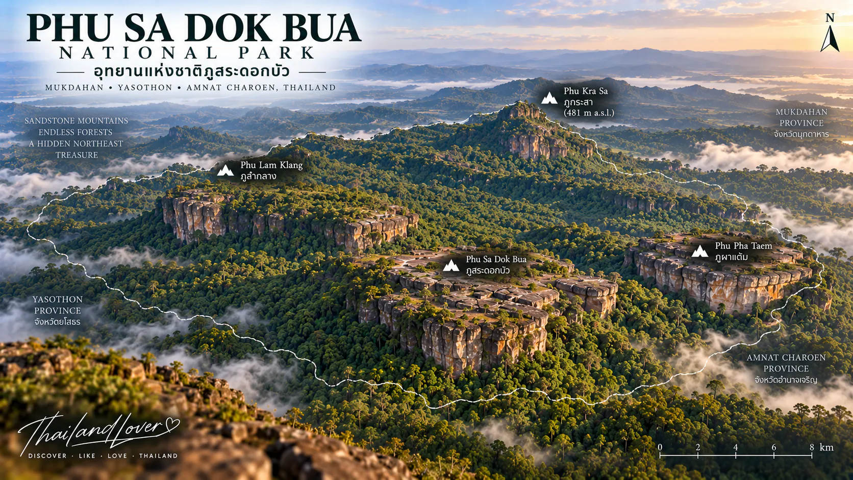
Phu Sa Dok Bua National Park is one of northeastern Thailand’s more unusual protected landscapes. Straddling the boundaries of Mukdahan, Yasothon and Amnat Charoen, the park protects approximately 231 square kilometres of forested mountains, sandstone plateaus, rocky terraces and important watersheds.
Its name means, roughly, “Lotus Flower Mountain.” The reason becomes clear when you reach the summit. Scattered across the top of Phu Sa Dok Bua are 11 natural rock pools, each holding water and supporting small lotus plants. There are no landscaped ponds here and no ornamental garden. The pools occur naturally among the sandstone.
But the lotus pools are only part of the story. Elsewhere, prehistoric handprints and painted symbols survive beneath a sandstone overhang. Seasonal wildflowers appear across open rocky plateaus. Old conflict-era sites reveal another layer of the area’s history.
Phu Sa Dok Bua is therefore a destination of nature, geology, archaeology and local history — all within one mountain landscape, and a distinctive stop in ThailandLover’s Nature & Parks collection.
A lotus growing on a mountain. A human hand preserved in stone. A flower blooming on bare rock.
At a Glance
- Official Name
- Phu Sa Dok Bua National Park
- Thai Name
- อุทยานแห่งชาติภูสระดอกบัว
- Region
- Northeastern Thailand — Isan
- Provinces
- Mukdahan, Yasothon & Amnat Charoen
- Area
- Approximately 231 km² / 144,375 rai
- National Park Status
- Thailand’s 75th national park
- Established
- 30 December 1992
- Highest Peak
- Phu Krasae — approximately 481 m
- Landscape
- Mountain ranges, sandstone cliffs, rocky plateaus and forest
- Signature Feature
- 11 natural lotus-filled rock pools
- Other Highlights
- Phu Pha Taem rock art, Phu Pha Hom, Phu Wat wildflowers, Phu Pha Taek
Why Visit Phu Sa Dok Bua?
This is not the kind of national park you visit for one giant waterfall. Its attraction is its combination of unusual details.
A mountain summit contains natural pools filled with lotus. A sandstone cliff carries prehistoric handprints. Rock terraces become covered with tiny wildflowers toward the end of the rainy season. Dry forest grows around broad slabs of exposed sandstone. Mountain viewpoints reveal a landscape extending toward the surrounding provinces.
The park is particularly rewarding for travelers who enjoy geology, archaeology, hiking, photography and lesser-known places in Thailand.
- Hike to 11 natural lotus pools on a 423-metre sandstone summit
- Stand beneath prehistoric handprints at Phu Pha Taem
- Watch sunset from Phu Pha Hom toward named Isan ranges
- Walk Phu Wat when small seasonal flowers occupy the rock
- Photograph Huai Hin Kho Reservoir from the plateau above
- Read a quieter layer of modern history at Phu Pha Taek
A Mountain Landscape Between Three Provinces
Phu Sa Dok Bua stretches across Mukdahan (Nikhom Kham Soi and Don Tan), Yasothon (Loeng Nok Tha) and Amnat Charoen (Chanuman and Senangkhanikhom). The mountain ranges generally run from northwest to southeast.
Average elevations are around 350–450 metres, with Phu Krasae forming the highest point at approximately 481 metres above sea level, according to the Department of National Parks. The mountains feed streams including Huai Thom, Huai Kabok, Huai Kan Lueang, Huai Lam Klang, Huai Khilek, Huai Hin Khua, Huai Tup and Huai Hai.
Do not plan the itinerary as if every attraction were within walking distance of headquarters. This is a large mountainous park; distances between named peaks matter.
The Forest
Phu Sa Dok Bua is predominantly a forest landscape. These woods create much of the park’s characteristic Isan scenery: open rock, low trees, grass and distant mountain views.
- Mixed Deciduous Forest
- Seasonal forest that turns green and dense in the rains, then more open in the dry months — fallen leaves, exposed ground and easier reading of the stone.
- Dry Evergreen Forest
- Patches around the mountain areas that hold shade and important wildlife habitat when the plateaus bake.
- Dwarf Dry Dipterocarp Forest
- Low-growing woodland adapted to exposed sandstone — the look that makes the dan plateaus feel almost savanna-like.
Wildlife
Species recorded by the Department of National Parks include muntjac, wild boar, golden jackal, foxes, civets, monkeys, porcupines, mouse deer, flying squirrels, bats, Siamese fireback, red junglefowl and other forest birds.
Sightings are unpredictable. The park is a natural habitat rather than a viewing enclosure. Move quietly and observe from a distance.
Phu Sa Dok Bua · The Mountain of Lotus Pools
ภูสระดอกบัว · approximately 423 m
This is the feature that gives the national park its name. Near the summit are 11 natural rock pools, generally around 2–3 metres across. They collect rainwater in depressions within the sandstone. Small lotus plants grow naturally in the pools, producing flowers when conditions are right.
Instead of seeing lotus in a conventional wetland, you find them in small pools of water trapped in mountain rock. That combination of mountain, sandstone and lotus is the defining image of the park.
Rainwater + natural rock basins + aquatic plants = a remarkable mountain ecosystem.
Local accounts say lotus have grown here for generations. Flowering can vary. Do not assume every pool will always be covered in blooms — and do not enter the water. Observe without disturbing plants or pools.
Phu Pha Taem · Prehistoric Hands on the Rock
ภูผาแต้ม
One of the park’s most important archaeological attractions, about 500 metres from headquarters: a sandstone cliff with a small rock shelter. On the surface are prehistoric paintings and handprints — approximately 98 images, positioned roughly 3–5 metres above the floor of the shelter.
Thai tourism sources commonly describe the paintings as about 3,000 years old; more recent provincial information gives a range of about 3,000–4,000 years. For ThailandLover, the safest wording is:
Prehistoric rock paintings and handprints believed to date back approximately 3,000–4,000 years.
That avoids presenting an exact archaeological date as more certain than the evidence supports.
- What you can see
- Red handprints, geometric patterns, symbolic forms and other painted motifs. The red pigment is generally believed to come from mineral material mixed with a binder such as tree resin. The precise meaning of the designs is not established — some interpretations compare forms to maps or symbols, but treat those as interpretations, not confirmed meanings.
- The viewpoint above
- An open plateau of about one rai looks across forested hills, dry dipterocarp woodland, sandstone, Huai Hin Kho Reservoir and surrounding mountains. Suitable for sunrise or sunset depending on conditions and access. The Phu Pha Taem route can take about two hours for exploration.
- Pha Mak Khluea
- Nearby, a shaded rest under a sandstone overhang — a simple attraction that fits the park perfectly: rock, forest and quiet.
Never touch, trace, chalk, paint or otherwise interfere with the paintings.
Viewpoints, Flowers & Water
- Phu Wat
- Seasonal wildflowers on an open rocky plateau — Dusita, Soi Suwanna, Kradum Ngoen, En-nga and other small species toward the end of the rainy season. This is a subtle landscape, not a giant flower field. Slow down. Watch your step; small blooms hide among rock and grass. Do not pick them.
- Phu Pha Hom · approximately 366 m
- A major western viewpoint. The route passes bamboo, exposed rock and dry dipterocarp forest. Ranges visible from the area include Phu Mu, Phu Phaeng Ma, Phu Mai Sang, Phu Song and Phu Akkharat. Late afternoon warms the sandstone.
- Phu Pha Taek
- A viewpoint with two layers: northern mountain scenery toward the landscape around Mukdahan National Park, and historical association with armed conflict during Thailand’s communist insurgency. A natural lookout with modern historical significance.
- The stone plateaus · dan
- Extensive rock courtyards, some covering many rai, interspersed with dwarf dry dipterocarp woodland. Bare sandstone → low trees → grasses → distant mountains. Greener in the rains; more stone-forward as the dry season progresses.
- Huai Hin Kho Reservoir
- A quiet water landscape near Phu Pha Taem — forest, hills and a different photographic composition from the exposed plateaus. Part of the panorama from the Phu Pha Taem plateau.
A Landscape with Modern History
Between approximately the mid-1960s and early 1980s, parts of this remote forested landscape were associated with communist insurgent activity. Difficult terrain, caves and forest provided natural advantages away from government-controlled areas. After combatants surrendered in the early 1980s, land-use and forest-management issues became increasingly important.
This history is part of why Phu Sa Dok Bua is more than a purely natural destination. The forest preserves layers of ecological and human history — from prehistoric handprints to a more recent, difficult chapter.
Best Time to Visit
- Rainy season · May–October
- Forest greens and streams receive more water. Trails and sandstone can be slippery.
- Late rainy season · around September–November
- One of the most interesting periods for wildflowers on the rocky plateaus. Water may remain in pools and the reservoir.
- Cool season · November–January
- More comfortable hiking. The dry forest opens; viewpoints can be clear.
- Hot season · February–April
- Exposed sandstone becomes very hot at midday. Prefer early morning and late afternoon.
Experiences by season
- Comfortable hiking
- November–February
- Green forest & stronger streams
- Rainy season
- Seasonal wildflowers
- Late rainy season – early cool season
- Sunrise photography
- Clear-season mornings
- Sunset photography
- Dry / cool season afternoons
- Lotus pools
- When water and flowering conditions are suitable
Things to Do
- Explore Phu Pha Taem — rock art and the plateau viewpoint in one walk
- Make the lotus-pool summit the centerpiece of a dedicated hiking day
- Walk among seasonal flowers at Phu Wat toward the end of the rains
- Watch sunset from Phu Pha Hom
- Take time on the geological dan plateaus rather than rushing past them
- Photograph Huai Hin Kho as a quieter water composition
- Learn the local history at former conflict landscapes such as Phu Pha Taek
Hiking & Difficulty
The short approach to Phu Pha Taem is considerably easier than the longer journey to the Phu Sa Dok Bua summit. Plan according to the specific attraction rather than treating the entire national park as one trail.
For longer or remote routes, confirm current access and whether a park officer or advance coordination is required. Wear hiking shoes — rock surfaces become slippery when wet. Bring more water than you think you need; exposed sandstone can feel hot even when the air is moderate. Start early.
Photography Guide
- Phu Pha Taem
- Photograph the rock shelter and surrounding landscape together rather than only individual paintings. The relationship between the site and the mountain is part of the story.
- Lotus pools
- A telephoto or medium lens isolates individual pools and flowers against the sandstone.
- Phu Wat
- A macro lens helps — many seasonal flowers are very small.
- Phu Pha Hom
- Late-afternoon light reveals texture in the exposed stone.
- Reservoir
- Use water as foreground and mountains as background.
How to Get There
Headquarters: Ban Nong Mek, Pa Rai Subdistrict, Don Tan District, Mukdahan Province — beside Huai Hin Kho Reservoir. The park sits on the road network connecting Don Tan, Mukdahan and Loeng Nok Tha. DNP notes the headquarters is about 60 km from Mukdahan city and about 28 km from Loeng Nok Tha.
A private car or rental vehicle is the most practical option for independent travelers, especially if visiting several attractions. The park covers a large mountainous area.
Where to Stay
The national park provides park accommodation and camping around the visitor area, plus a visitor centre, toilets and recreation space. Availability varies with season and management. Confirm before you travel.
For more restaurants and hotels, base yourself in Mukdahan or nearby towns and visit as a day trip.
Travel Tips
- Bring plenty of water — sandstone holds heat
- Wear hiking shoes with grip
- Protect the rock art: look, do not touch
- Do not enter the lotus pools
- Do not pick wildflowers
- Watch your step on flower plateaus
- Start early for longer hikes
- Check trail, fire-prevention and weather closures
- Carry out your waste — remote areas have limited facilities
Essential Information
- Park
- Phu Sa Dok Bua National Park — Mukdahan · Yasothon · Amnat Charoen
- Area
- Approximately 231 km² / 144,375 rai
- Established
- 30 December 1992 · Thailand’s 75th national park
- Highest Point
- Phu Krasae — approximately 481 m
- Main Forests
- Mixed deciduous and dry evergreen, with dwarf dry dipterocarp on the plateaus
- Phu Sa Dok Bua
- A 423-metre mountain with 11 natural rock pools containing small lotus plants.
- Phu Pha Taem
- Prehistoric handprints and painted symbols, believed to date back approximately 3,000–4,000 years.
- Phu Pha Hom
- Wide western views and sunsets.
- Phu Wat
- Seasonal wildflowers on an open rocky plateau.
- Phu Pha Taek
- Viewpoint with scenery and modern political history.
- Huai Hin Kho Reservoir
- Quiet water surrounded by forest and mountain scenery.
Frequently Asked Questions
- Where is Phu Sa Dok Bua National Park?
- Northeastern Thailand, across Mukdahan, Yasothon and Amnat Charoen. Headquarters are at Ban Nong Mek, Pa Rai, Don Tan District, Mukdahan.
- What does the name mean?
- Roughly “Lotus Flower Mountain,” from the eleven natural sandstone pools that can hold lotus near the summit of Phu Sa Dok Bua.
- Will I definitely see lotus in bloom?
- No. Flowering depends on water remaining in the pools and seasonal conditions. The geological setting is remarkable even when blooms are sparse.
- How much time do I need?
- Phu Pha Taem can be explored in about two hours. The lotus-pool summit is closer to a full-day hike. Spread viewpoints across more than one day if you can.
- Is this the same as Phu Pha Thoep or Pha Taem?
- No. They are separate parks. Phu Pha Thoep is a compact sandstone park nearer Mukdahan city. Pha Taem is a Mekong-cliff park in Ubon Ratchathani. Phu Sa Dok Bua is the three-province lotus-pool landscape.
- Can I camp?
- The park has offered camping and park lodgings. Confirm availability, fees and facilities directly with the park before you rely on them.
Related Destinations
- Phu Pha Thoep National Park
- Mukdahan’s compact sandstone garden — Hin Thoep formations and Mekong-horizon cliffs.
- Phu Pha Yon National Park
- Neighbouring sandstone country with reservoir, wildflowers and ancient cliff carvings.
- Pha Taem National Park
- Mekong cliffs and prehistoric paintings in Ubon Ratchathani — related rock-art culture on a larger canvas.
- Phu Phan National Park
- The wider Phu Phan mountain system of Isan sandstone forest.
- Phu Phrabat Historical Park
- UNESCO sandstone shelters in Udon Thani — geological cousins with a deeper sacred story.
Location
Find Phu Sa Dok Bua National Park
Ban Nong Mek, Pa Rai · Don Tan · Mukdahan · Northeastern Thailand