


National Park · Ubon Ratchathani
Kaeng Tana National Park
อุทยานแห่งชาติแก่งตะนะ
Where the Mun River Runs Wild
Ubon Ratchathani · Northeastern Thailand — Isan
A compact sandstone river landscape of rapids, rocky islands, dry forest, waterfalls and ancient inscriptions — where land and water still write the same story.
Where the Mun River Runs Wild
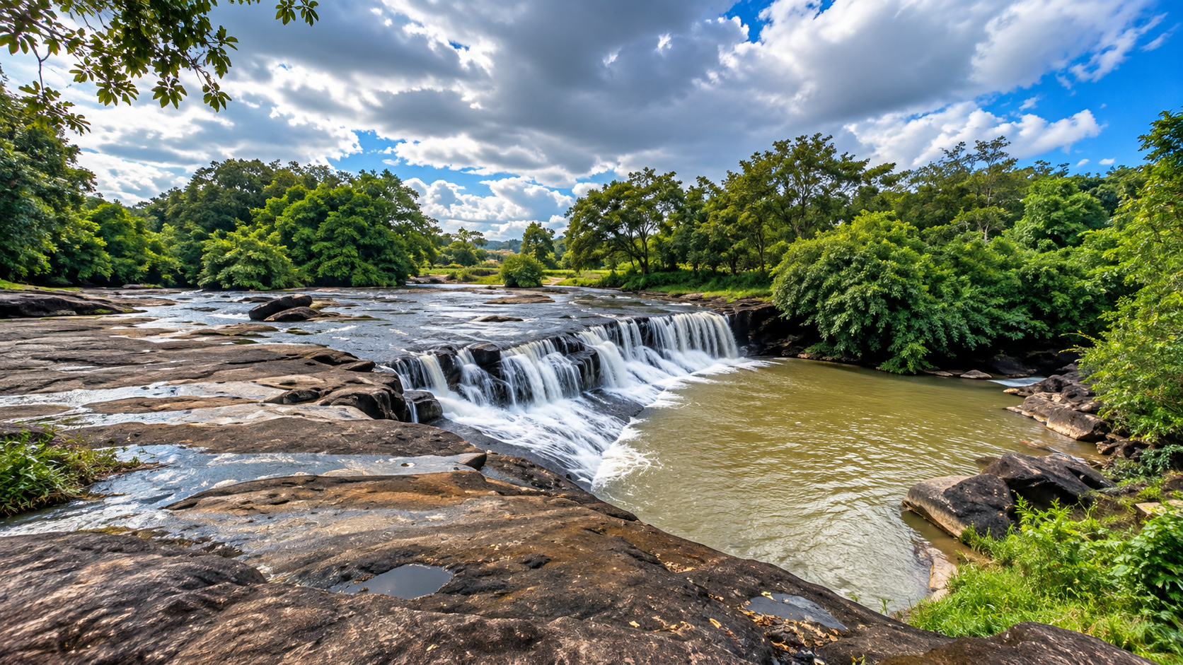
In the easternmost reaches of Ubon Ratchathani, where the Mun River cuts through an ancient sandstone landscape, a world of rapids, rocky islands, dry forest and open plateaus unfolds.
This is Kaeng Tana National Park.
It is a relatively small national park by Thailand’s standards, covering approximately 80 square kilometres, but its landscape is unusually concentrated.
Here, a single river shapes the character of the park. Rock formations rise from the Mun River. Sandstone platforms are exposed when the water falls. Forest covers the surrounding hills. Waterfalls appear among the uplands. And ancient traces of human civilization connect the landscape to the wider history of the Mun River basin.
Kaeng Tana is not simply a place to see a waterfall.
This sandstone river landscape is a standout destination in ThailandLover’s Nature & Parks collection.
It is a place to understand how river, rock, forest and history intersect in eastern Isan.
Kaeng Tana at a Glance
- Official Name
- Kaeng Tana National Park
- Thai Name
- อุทยานแห่งชาติแก่งตะนะ
- Province
- Ubon Ratchathani
- Region
- Northeastern Thailand — Isan
- Area
- Approximately 80 sq km
- Established
- 13 July 1981
- National Park
- 33rd national park of Thailand
- Districts
- Sirindhorn and Khong Chiam
- Landscape
- Upland terrain, low hills, sandstone, dry forest and river systems
- Principal River
- Mun River
- Highest Point
- Phu Banthat / Khao Banthat area
- Signature Landscape
- Kaeng Tana Rapids and Don Tana
- Major Waterfalls
- Soi Sawan and Tat Ton
- Historic Feature
- Prince Chitrasena Inscription
The Character of Kaeng Tana
Some national parks are defined by enormous mountains. Others are defined by beaches, limestone cliffs or giant waterfalls.
Kaeng Tana is different. Its identity comes from the relationship between land and water.
The Mun River passes through a landscape of sandstone. Where harder rock resists erosion, rapids and rocky islands develop. Where the river has removed softer material, channels and pools form. Where streams descend from the uplands, waterfalls appear. And where seasonal rainfall disappears, exposed rock platforms reveal the geological structure of the landscape.
This makes Kaeng Tana particularly interesting for travellers who want to see the physical geography of Thailand rather than simply photograph a famous attraction.
Where Is Kaeng Tana National Park?
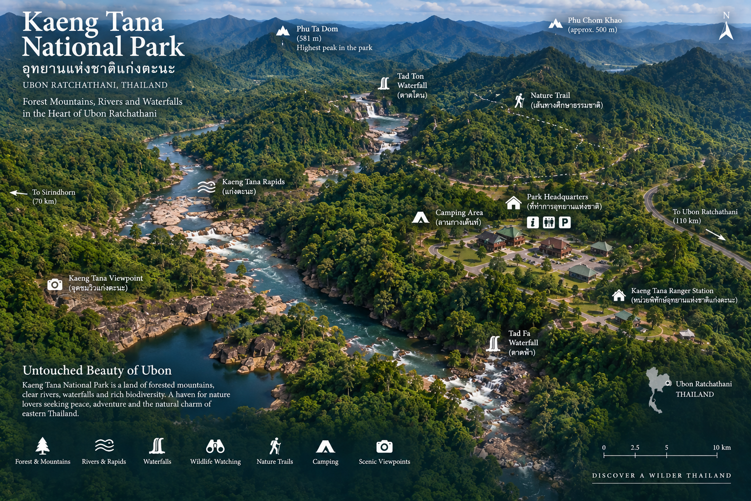
Kaeng Tana is located in Ubon Ratchathani Province, in northeastern Thailand. The park covers areas of Sirindhorn District and Khong Chiam District.
It lies within the eastern part of Ubon Ratchathani, an area where the Mun River approaches its confluence with the Mekong. The wider landscape is part of one of the most distinctive geographical areas of eastern Isan — where the Mun River, Mekong River and the sandstone plateaus of the Khorat region come together.
TAT places Kaeng Tana within the natural and cultural travel landscape of eastern Ubon Ratchathani alongside destinations such as Sirindhorn Dam, Pak Mun Dam and Pha Taem National Park.
How Kaeng Tana Got Its Name
The name Kaeng Tana comes from the famous rapids in the Mun River.
According to the traditional local explanation recorded by TAT, the river section was historically dangerous because of its strong current, numerous rocks and underwater cavities. The area was therefore associated with the idea of “Morana” — death, before the name evolved into “Tana.”
This is a traditional explanation of the place name rather than a geological definition.
What is certain is that the river’s powerful current and rocky channel are fundamental to the identity of the park.
A Landscape Shaped by Sandstone
One of the most important things to understand about Kaeng Tana is its geology. The park sits within the sandstone landscape of the Khorat Plateau.
At Kaeng Tana itself, large sandstone formations occur directly within the Mun River. The Department of Mineral Resources identifies Kaeng Tana and Don Tana as an important geomorphological site.
The rocks at Kaeng Tana belong to the Phu Phan Formation of the Khorat Group. They include sandstone, conglomeratic sandstone, conglomerate, sandstone interbeds and reddish-brown siltstone. The sandstone beds are generally around 30–80 centimetres thick in the documented geological section.
This geological structure explains much of what visitors see. The river has spent enormous amounts of time eroding the landscape. But where the underlying sandstone is harder and more resistant, rock remains.
Those resistant rock surfaces become rapids, rocky islands, channels and exposed rock platforms.
Kaeng Tana Rapids
แก่งตะนะ
The park’s namesake is the Kaeng Tana rapids, located in the Mun River. It is one of the most visually distinctive features of the park.
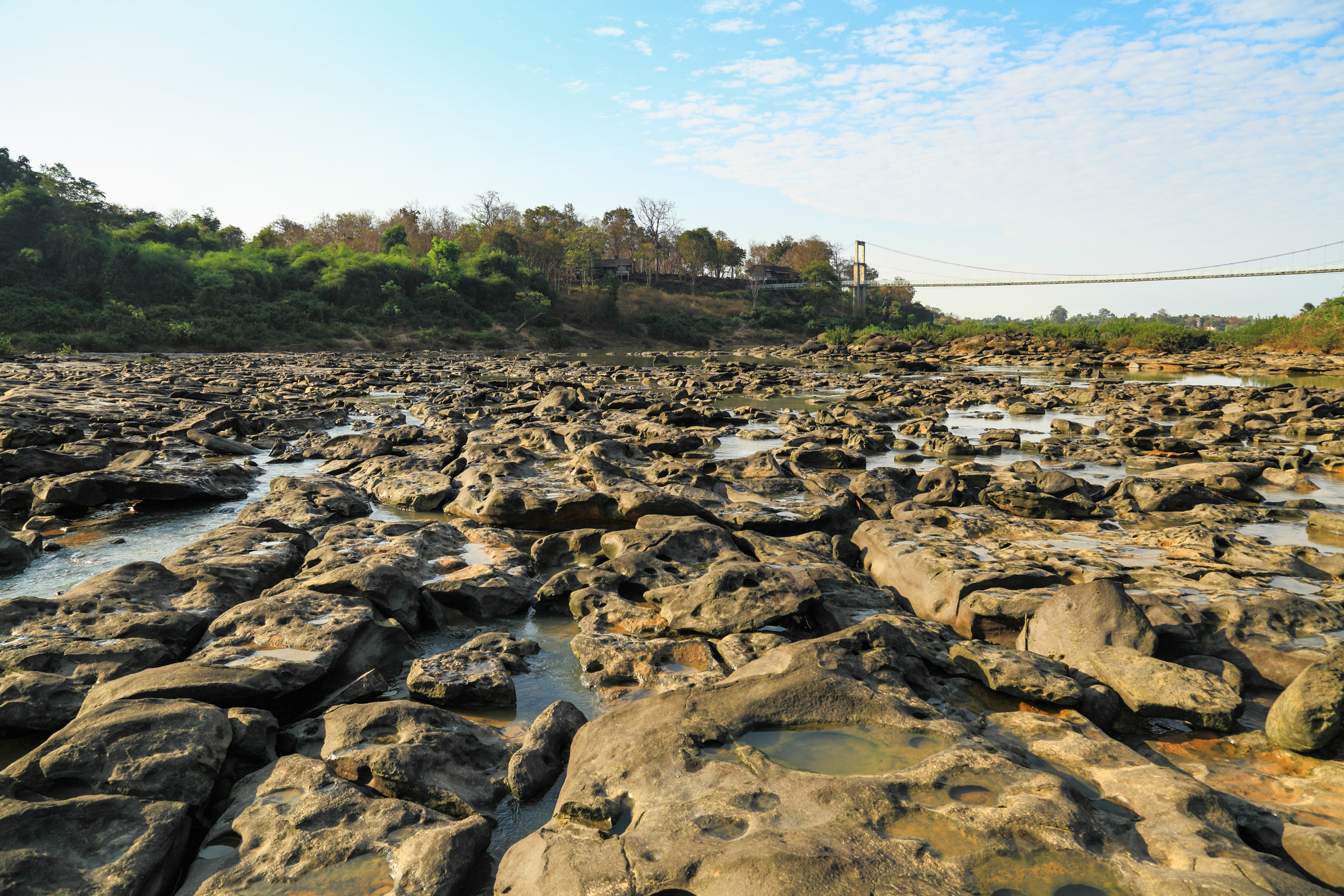
Large sandstone rocks occupy the river channel, forcing water to divide and accelerate around them. During periods of lower water levels, more of the underlying rock becomes visible. During higher water levels, the same geological structure can be largely submerged.
This seasonal transformation is one of the reasons Kaeng Tana can look dramatically different at different times of year.
The Department of Mineral Resources describes Kaeng Tana as a large sandstone-rock formation within the Mun River. The rock surface contains numerous potholes, created by erosion from the river.
River Meets Rock
The potholes visible in the sandstone are not decorative features. They are evidence of geological processes.
Pebbles and sediment can become trapped in small depressions. Moving water rotates these materials. Over time, the rotating material acts like an abrasive tool, gradually enlarging the depression. Eventually, rounded holes or kettle-like potholes develop in the rock surface.
At Kaeng Tana, these features are particularly visible on exposed sandstone surfaces during lower water conditions.
Kaeng Tana is not simply a river with rocks.
It is a living geological landscape.
Don Tana
ดอนตะนะ
Across the river system lies another defining landscape feature: Don Tana.
Geologically, Don Tana is different from Kaeng Tana. While Kaeng Tana is dominated by resistant rock formations in the river channel, Don Tana is a sedimentary sandbar and island formed by deposition.
The Department of Mineral Resources describes Don Tana as a large sandbar formed by sediment accumulation along the inner side of a river bend.
Kaeng Tana = erosion-resistant sandstone. Don Tana = accumulated river sediment.
Together they demonstrate how a river can simultaneously erode one area and build another.
Don Tana Forest
Don Tana is not simply a sandbank. Vegetation has established itself on the island, creating a forested river environment. The island landscape provides shade and a different atmosphere from the exposed rock of the rapids.
The contrast between river, rock, sand and forest is one of Kaeng Tana’s most characteristic visual combinations.
A Park of Upland Forests
TAT describes the general terrain of Kaeng Tana as uplands and low hills. The forest contains areas of relatively stunted trees, together with open grassland landscapes.
This is different from the towering evergreen rainforest found in many southern Thai national parks. Kaeng Tana’s vegetation reflects the drier seasonal climate of northeastern Thailand.
The landscape can therefore feel open, sunlit and rugged. During the wet season, vegetation becomes greener and streams become more active. During the dry season, exposed rock and grassland become much more visually prominent.
Dry Forest and Seasonal Change
The seasonal rhythm is fundamental to understanding Kaeng Tana. The park is not a destination with one fixed appearance. It is a landscape that changes with the water.
- Wet season
- Streams become stronger, waterfalls more impressive, forest intensely green, grasslands recover and river levels rise.
- Dry season
- Sandstone platforms become exposed, rock formations easier to examine, rapids more visually defined, dry forest more open — and some waterfalls may have reduced flow.
Waterfalls of Kaeng Tana
At first glance, Kaeng Tana’s waterfalls and river rapids may seem unrelated. They are not. Both are expressions of the same process: water moving through a resistant sandstone landscape.
Soi Sawan Waterfall
น้ำตกสร้อยสวรรค์ · Approximately 30 metres
One of Kaeng Tana’s best-known waterfalls is Soi Sawan Waterfall. It is formed by two streams — Huai Sroi and Sa Phai — which descend and converge into the waterfall system.
Their combined appearance resembles a necklace or chain — hence the name Soi Sawan, close to a heavenly necklace. Tourism descriptions place the waterfall at approximately 30 metres high.
The surrounding rocky area becomes particularly attractive toward the end of the rainy season and the beginning of the cool season, when seasonal flowers can appear across the rock platforms.
Tat Ton Waterfall
น้ำตกตาดโตน
Tat Ton originates from Huai Tat Ton, which flows across a rock platform before dropping into a lower basin. The surrounding forest provides shade and creates a quieter environment than the open river rapids.
Tat Ton is particularly attractive during the rainy season through the early part of the dry season. Tourism descriptions commonly identify June–October as a suitable period for seeing stronger flow. As with all waterfalls, actual conditions vary according to rainfall.
Prince Chitrasena Inscription
หลักศิลาจารึกเจ้าชายจิตรเสน
Kaeng Tana is not purely a natural destination. It also contains an important archaeological and historical record.
On 11 July 1991, a sandstone inscription associated with Prince Chitrasena was discovered on the bank of the Mun River at the mouth of Lam Dom Noi, within Kaeng Tana National Park, in Kham Khuean Kaeo Subdistrict, Sirindhorn District.
The inscription is carved on a sandstone semā-shaped stone approximately 38.8 cm wide, 147 cm high and 37.7 cm thick. It contains Pallava script and Sanskrit text arranged in six lines.
What does the inscription say?
The inscription refers to King Chitrasena, whose royal name was Śrī Mahendravarman. The text records military victories over Cambodia and refers to the establishment of a Shiva linga and other religious images associated with Shaivism.
The Department of National Parks identifies the inscription as significant evidence of the ancient cultural landscape of the Chi and Mun river basins, particularly around the 11th–12th Buddhist centuries.
The river was not only a natural transportation and ecological corridor. It was also part of an ancient cultural network.
Why the Mun River Matters
The Mun River is one of the defining rivers of northeastern Thailand. It crosses a large portion of the Isan plateau before eventually joining the Mekong system.
At Kaeng Tana, the river becomes especially dramatic because of the sandstone formations through which it passes. It is simultaneously a geographic feature, a geological force, an ecological corridor, a source of local livelihoods, a historical transportation route and a defining visual element of the national park.
This is why Kaeng Tana is best understood as a river landscape, rather than simply a forest park.
Kaeng Tana and the Mekong landscape
Kaeng Tana sits in the eastern Ubon Ratchathani landscape close to the Mun–Mekong region. Nearby Khong Chiam is particularly important because the Mun River eventually reaches the Mekong.
A visit works particularly well as part of a wider eastern Ubon journey that includes Sirindhorn Dam, Pak Mun, Khong Chiam, Pha Taem National Park and Mekong viewpoints. TAT includes Kaeng Tana in multi-day Ubon Ratchathani itineraries alongside these destinations.
Nature Trails
Kaeng Tana’s attractions are connected by short nature-oriented routes and access roads rather than a single long mountain trek.
Short walks + viewpoints + waterfalls + river landscapes
The experience is more suitable for travellers who want to combine those elements than to undertake a multi-day wilderness expedition. One of the attractions highlighted in tourism information is the landscape around the river and Don Tana, where visitors can experience the forest and river environment at relatively close range.
Wildlife and Birdwatching
Kaeng Tana provides habitat for wildlife associated with the dry forests and riverine environments of eastern Isan. The most responsible description is this:
Kaeng Tana protects a mosaic of dry forest, grassland, riverine vegetation and sandstone habitats that supports a range of wildlife and bird species.
Visitors should not expect guaranteed sightings. The park is a functioning ecosystem, not a wildlife enclosure. Early morning and late afternoon are generally the most rewarding times for observing natural activity.
Birdwatching
The mixture of woodland, open grassland, river, forest edge and rocky habitats creates a variety of ecological niches. This makes Kaeng Tana interesting for birdwatchers who enjoy species associated with open woodland and river environments.
The best approach is to travel slowly and listen. In a relatively open landscape, bird calls can often reveal more than the eye does.
The Geological Story of Kaeng Tana
The Department of Mineral Resources identifies Kaeng Tana and Don Tana as a geomorphological site of significance. The story can be summarised simply:
- 1. Ancient sediment was deposited
- Sand and gravel accumulated in ancient environments.
- 2. Sediment became rock
- Over geological time, the deposits hardened into sandstone and related rocks.
- 3. The land was uplifted
- Regional geological processes raised the landscape.
- 4. Rivers began cutting through it
- Water progressively eroded the terrain.
- 5. Harder rock remained
- Where sandstone resisted erosion, rocky islands and rapids developed.
- 6. Sediment accumulated elsewhere
- In areas of slower flow, sand created features such as Don Tana.
- 7. The process continues
- Every rainy season continues the geological story.
Kaeng Tana is a landscape still being shaped.
The Human Landscape
Historical accounts of Kaeng Tana describe a square structure on the rocks within the rapids, associated with the period when French colonial influence extended through neighbouring Laos. The structure is traditionally described as having been used as a navigation marker for river traffic.
This should be understood as a historical account rather than confused with a modern navigational facility. Its significance lies in what it reveals about the importance of the Mun–Mekong river corridor for movement in the region.
The Mun River has historically supported fishing, transportation, agriculture, settlement and cultural exchange. The national park designation places limits on resource use within the protected area, but the wider river system remains closely connected with local communities.
The landscape should not be viewed as untouched wilderness in the absolute sense. It is a protected natural landscape embedded within a long-lived human geography.
Best Experiences at Kaeng Tana
- Stand above the Mun River
- The river is the park’s central visual experience. Watch the water divide around the sandstone formations.
- Explore Don Tana
- Experience the contrast between the exposed river rocks and the forested sediment island.
- See Kaeng Tana during lower water
- More of the sandstone structure and potholes become visible. The landscape becomes almost geological sculpture.
- Visit Soi Sawan Waterfall
- Especially during and after the rainy season, when flowers can appear on the rock platforms.
- Visit Tat Ton Waterfall
- A quieter forest-and-water experience.
- Look for seasonal wildflowers
- The rocky areas around waterfalls can become particularly colourful toward the end of the rainy season.
- Explore the historical dimension
- The Prince Chitrasena inscription adds an entirely different layer to the landscape.
When Is the Best Time to Visit?
There is no single best month for every experience.
- November–February
- Generally more comfortable for outdoor exploration, walking and sightseeing.
- March–May
- Hotter and drier. Rock formations and river landscapes can become more visually prominent because water levels may be lower.
- June–October
- Rainfall increases. Waterfalls become more attractive, vegetation greener. Soi Sawan and Tat Ton can be particularly rewarding — but heavy rain can make trails and rocks slippery.
The best season for photography
- Waterfalls and green forest: rainy-season period
- Geology and exposed sandstone: lower-water periods
- Comfortable sightseeing: cooler months
Kaeng Tana does not have one universally “best” season. The best season depends on what you want to photograph.
How to Get There
From Ubon Ratchathani city, the main approach is via Highway 217, the Ubon Ratchathani–Phibun Mangsahan–Chong Mek route.
Highway 217 ≈ 75 km → Highway 2173 ≈ 13 km → Kaeng Tana National Park
This makes Kaeng Tana practical as a day trip from Ubon Ratchathani, although travellers who want to explore Khong Chiam and eastern Ubon should consider staying overnight in the wider area.
Getting around
The main attraction areas are distributed across the park. A private car is the most practical option for independent travellers. The park is not designed around a continuous public-transport network between every attraction.
Plan the day geographically rather than assuming that every attraction is immediately adjacent to the headquarters.
Facilities
Facilities within a national park environment are generally simpler than those found in commercial tourist destinations. Depending on current park operations, visitors may find visitor facilities, parking, toilets, camping, park accommodation, ranger facilities and information services.
Availability can change. Accommodation and camping should therefore be checked directly with the park before travel.
Safety
Kaeng Tana contains genuine river hazards. The name itself reflects the historical reputation of the rapids. Visitors should never underestimate the Mun River.
- Around the rapids
- Do not enter fast-moving water. Do not climb wet rocks near strong currents. Do not attempt to cross the river through rapids.
- Around waterfalls
- Rock surfaces can become extremely slippery after rain. Swimming should only be considered where officially permitted and where conditions are safe.
- During storms
- Avoid exposed rocks and riverbanks during severe weather. Water levels can change rapidly.
- Wildlife
- Do not feed animals, approach wildlife or leave food waste in camping areas.
Responsible Travel
Kaeng Tana is a relatively compact national park. That makes responsible tourism particularly important.
- Carry rubbish out
- Avoid single-use plastic where possible
- Stay on designated routes
- Never collect rocks or plants
- Never remove archaeological material
- Avoid damaging sandstone formations
- Keep noise low
- Respect wildlife
- Follow ranger instructions
- Avoid entering closed areas
The sandstone landscape is ancient. A photograph lasts forever. A carved name does not belong on it.
Not Just Another Waterfall Park
This is perhaps the most important point for ThailandLover. Kaeng Tana should not be presented as “a national park with waterfalls and rapids.” That description is technically correct but misses the reason the park matters.
A sandstone river landscape where geology, ecology and ancient history meet.
The rapids reveal the geology. The waterfalls reveal the elevation. The forest reveals the climate. The inscription reveals the history. The Mun River connects them all.
Kaeng Tana, Pha Taem and Sirindhorn
Kaeng Tana and Pha Taem are geographically close enough to be combined into an eastern Ubon itinerary, but they are not the same experience.
- Pha Taem
- Dramatic cliffs, Mekong viewpoints, prehistoric rock paintings, sandstone landscapes and sunrise.
- Kaeng Tana
- Mun River, Kaeng Tana rapids, Don Tana, waterfalls, dry forest, geological features and archaeological history.
Together they show two different expressions of eastern Ubon’s sandstone landscape.
Sirindhorn Dam lies in the same broader travel region. Combining Sirindhorn with Kaeng Tana can create a useful contrast: dam + river + forest + rapids. TAT includes Sirindhorn Dam, Pak Mun and Kaeng Tana within its recommended Ubon Ratchathani travel routes.
Suggested One-Day Experience
- Morning — Kaeng Tana Rapids
- Begin with the park’s defining landscape. Spend time understanding the river rather than immediately moving on.
- Morning — Don Tana
- Explore the forested river island and surrounding landscape.
- Midday
- Lunch and rest around the visitor area.
- Afternoon — Soi Sawan
- Explore the waterfall and surrounding rock landscape.
- Afternoon — Tat Ton
- Continue to the second major waterfall if conditions and access permit.
- Late afternoon
- Return toward the river. Use the final light for photography.
Suggested Eastern Ubon Journey
For travellers with more time, this creates a coherent geographical journey rather than a random collection of tourist attractions.
- Day 1
- Ubon Ratchathani city.
- Day 2
- Sirindhorn Dam → Kaeng Tana National Park.
- Day 3
- Kaeng Tana → Khong Chiam → Pha Taem.
- Day 4
- Mekong landscape → local communities → return to Ubon Ratchathani.
Why Kaeng Tana Matters
Kaeng Tana protects approximately 80 square kilometres of a distinctive eastern Isan landscape. Within that relatively compact area are a major river, sandstone rapids, river islands, dry forest, waterfalls, grassland, geological formations, archaeological evidence and historic river-navigation traces.
That concentration makes the park unusually rich in stories.
Essential Information
- Name
- Kaeng Tana National Park
- Thai
- อุทยานแห่งชาติแก่งตะนะ
- Province
- Ubon Ratchathani
- Region
- Northeastern Thailand
- Area
- Approximately 80 sq km
- Established
- 13 July 1981
- National Park No.
- 33
- Districts
- Sirindhorn & Khong Chiam
- Main River
- Mun River
- Signature Feature
- Kaeng Tana Rapids
- Major River Island
- Don Tana
- Major Waterfalls
- Soi Sawan, Tat Ton
- Geology
- Sandstone landscape / Phu Phan Formation
- Historical Feature
- Prince Chitrasena Inscription
- Best For
- Rivers, geology, waterfalls, forest, photography, history
- Main Access
- Highway 217 → Highway 2173
Frequently Asked Questions
- What is Kaeng Tana National Park?
- Kaeng Tana National Park, or อุทยานแห่งชาติแก่งตะนะ, is Thailand’s 33rd national park, established on 13 July 1981 in Ubon Ratchathani. It covers about 80 km² of sandstone river landscape on the Mun River, including Kaeng Tana rapids, Don Tana, Soi Sawan and Tat Ton waterfalls.
- Where is Kaeng Tana National Park?
- In eastern Ubon Ratchathani, covering parts of Sirindhorn and Khong Chiam districts, where the Mun River approaches its confluence with the Mekong.
- Why is it called Kaeng Tana?
- The name comes from the famous rapids in the Mun River. A traditional local explanation recorded by TAT associates the historically dangerous current with “Morana” — death — before the name evolved into Tana.
- What is Don Tana?
- Don Tana is a large sandbar and forested river island formed by sediment accumulation along the inner side of a river bend. It contrasts with Kaeng Tana’s erosion-resistant sandstone in the river channel.
- What waterfalls can you visit?
- Soi Sawan Waterfall is formed by Huai Sroi and Sa Phai and is about 30 metres high. Tat Ton Waterfall flows across a rock platform from Huai Tat Ton. Flow is generally stronger in the rainy season.
- When is the best time to visit?
- November–February is generally most comfortable for walking. Lower water can reveal more sandstone and potholes. June–October is better for waterfalls and green forest, though rocks can be slippery.
- How do I get there?
- From Ubon Ratchathani, follow Highway 217 toward Phibun Mangsahan and Chong Mek for about 75 km, then Highway 2173 for about 13 km to the park. A private car is the most practical option.
- Can Kaeng Tana be combined with Pha Taem?
- Yes. They are close enough for an eastern Ubon itinerary, but they are different experiences: Pha Taem for Mekong cliffs and rock paintings; Kaeng Tana for the Mun River, rapids, Don Tana and waterfalls.
- How do I contact the park?
- The Department of National Parks lists 0 4525 2722–3. Confirm opening status, camping, accommodation and current conditions before travelling.
Related Destinations
- Pha Taem National Park
- Mekong cliffs, sandstone plateaus and prehistoric rock paintings — the other side of eastern Ubon’s sandstone landscape.
- Nature & Parks
- More protected landscapes across ThailandLover’s national-park collection.
Location
Find Kaeng Tana National Park
Khong Chiam & Sirindhorn, Ubon Ratchathani 34220