


National Park · Phrae & Lampang
Mae Yom National Park
อุทยานแห่งชาติแม่ยม
Thailand’s Living Teak Forest
Song · Sae-Iap · Ngao
Not the highest mountain. Not the biggest waterfall. A river still running through natural teak — and a community that has spent decades arguing for both.
Written in the Trees
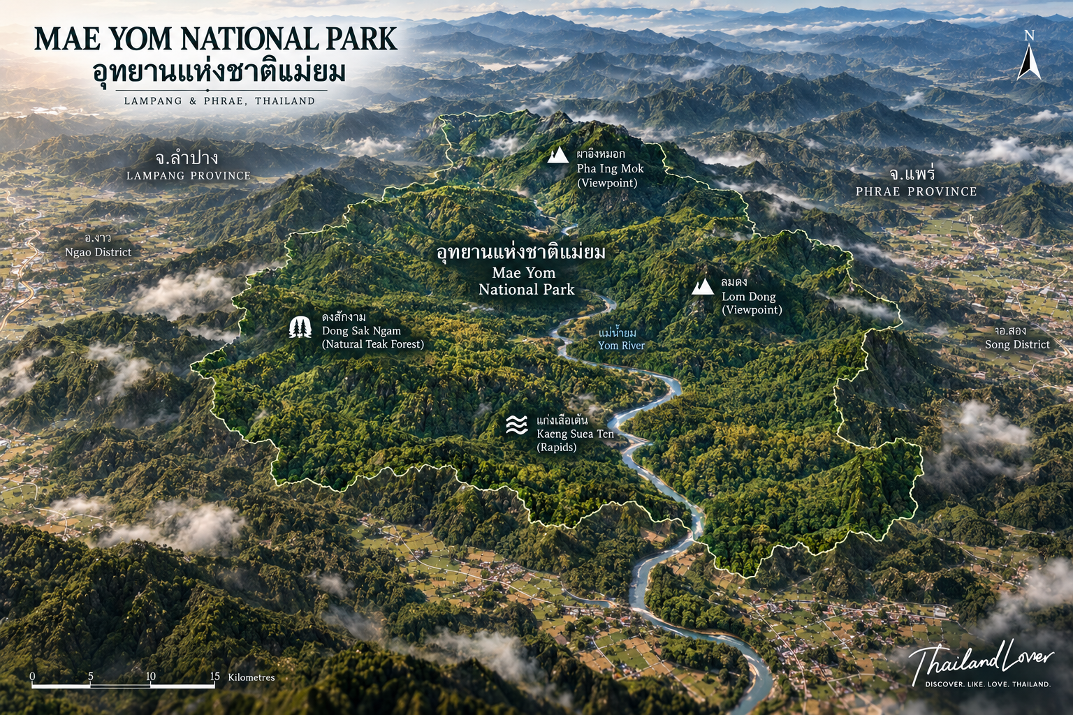
Some parks are famous for a summit. Some for a fall. Mae Yom’s identity is the forest itself. Along the valleys of the Yom River, teak grows as part of a northern woodland, not as rows in a plantation. At the centre of that landscape is Dong Sak Ngam. In front of the headquarters, Kaeng Suea Ten breaks the river into rock, channel and pool. Above it, Pha Ing Mok looks across mist and canopy.
For more than three decades the same river has also been the site of one of Thailand’s longest environmental arguments: the proposed Kaeng Suea Ten Dam. Today the park still offers something increasingly rare — water, teak, wildlife and people in one place, still connected.
A forest worth understanding, not only visiting.
At a Glance
- 51st
- National park of Thailand. Established 1 March 1986. Phrae and Lampang — not four provinces.
- 284,218.75 rai
- About 454.75 km² in the Phi Pan Nam Range. Song in Phrae. Ngao in Lampang.
- Teak, not a plantation
- Dong Sak Ngam. About 20,000 rai of dense natural teak in mixed deciduous forest.
- Check the river
- Seasonal closures exist. Floods in 2024 and 2026 have overridden the calendar.
- Thai name
- อุทยานแห่งชาติแม่ยม
- Provinces
- Phrae and Lampang
- Districts
- Song, Phrae · Ngao, Lampang
- Gateway
- Sae-Iap, Song District
- River
- Yom
- Signature forest
- Dong Sak Ngam · ดงสักงาม
- Signature river
- Kaeng Suea Ten · แก่งเสือเต้น
- Viewpoint
- Pha Ing Mok · ผาอิงหมอก
- Highland water
- Lom Dong · หล่มด้ง
- Forests
- Mixed deciduous, teak, evergreen and hill evergreen
- Best overall
- November–January
- Character
- Teak, river, mountain, community, conservation
Two Provinces, One River
The visitor gateway is on the Phrae side, around Sae-Iap Subdistrict, Song District. Headquarters and Kaeng Suea Ten sit in that landscape. The Lampang side continues into Ngao. Some travel sites stretch Mae Yom across four provinces. That usually describes a wider mountain, watershed or cultural country. The national-park baseline here is Phrae and Lampang.
The Phi Pan Nam ridges are not one peak. They are valleys, forested slopes, river corridors, streams, cliffs and small basins. Names that recur in descriptions of the high ground include Doi Luang, Doi Yao, Doi Khun Huai Pae and Doi Ton. Higher slopes are cooler. Lower valleys are warmer and more seasonal. The Yom cuts a corridor through all of it, then continues south to join the Nan system. Inside the park it shapes forest, banks, rapids, wildlife and the farms downstream.
Tributaries associated with the park include Mae Pung, Mae Lam, Mae Ten, Mae Sakuen, Mae Pao, Huai Pha Lat and Huai Mae Pong. Rain falls on the mountains. Soil holds it. Streams carry it. The river takes it on. Mae Yom is infrastructure for the Yom basin, not only a weekend view.
Dong Sak Ngam
ดงสักงาม · natural teak · about 20,000 rai
Tectona grandis is one of the defining trees of the north: valuable, logged, and increasingly important where it still grows as part of a mixed forest. Research in the Mae Yom woodland has described a mixed-deciduous community of dozens of tree species, with teak carrying very high ecological weight inside that community. That is the difference. A plantation can be replanted in rows. A mature natural forest holds soil, fungi, insects, birds, mammals, streams and genetic variety that a timber inventory does not.
Dong Sak Ngam is the forest that gives the park its soul — dense natural teak along the Yom landscape, trees rising irregularly rather than in a grid. Mature teak, other deciduous trees, bamboo, understory, riverine habitat, wildlife. Northern Thailand’s teak also carries a human history: forestry, local economies, colonial-era timber, Thai forest policy, conservation, livelihoods. What remains has historical weight as well as ecological weight.
Teak is deciduous. In the dry season the leaves fall, light enters, and the ground fills with litter — the classic open northern forest. Around the turn from the rains toward the cool months, historical descriptions note a striking flowering, a yellowish cast that can make the woodland look like another place. Timing follows rainfall. It is not a booked bloom.
Kaeng Suea Ten
แก่งเสือเต้น · the river heart · near headquarters
If Dong Sak Ngam is the forest, Kaeng Suea Ten is the river made visible. Rock breaks the Yom into channels and pools, with sandy banks, forest and open sky. Tourism sources describe the main scenic stretch as about 2–4 kilometres, depending on where the named section is said to begin. ThailandLover does not force one exact kilometre where the definitions differ. The name evokes “dancing tiger rapids.” Local tradition ties it to a rock associated with tiger footprints. Whether you read that as folklore or landscape memory, the name and the place are now the same thing.
When the water is safe and the attraction is open, this is the park’s easiest portrait: photography, a walk along the bank, camping beside the sound of the river, mist in the morning. It is also a mountain river. Levels can rise quickly after rain upstream. Swim or wade only where the park permits it, and only when staff consider it safe. In flood, stay off the rocks.
Mist, and a Pool on the Mountain
- Pha Ing Mok · ผาอิงหมอก
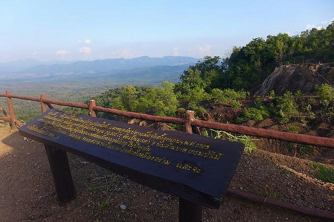
- The viewpoint to prioritise. Forest, ridges, teak canopy, valleys. On a cool morning the mist fills the lower country and the ridges sit above it. Arrive before sunrise: silhouettes, then the first light on the canopy. Wide for mist and sky. Longer lenses for the layers. The useful hour is sunrise and the hour after, not midday.
- Lom Dong · หล่มด้ง
- A large natural basin on the mountain, described in historical studies as about 100 metres across, holding water through the year. A wildlife water source in the dry season, not a puddle. The safest geological line is a highland basin believed to have formed by ground subsidence. Do not claim a proven sinkhole mechanism. Large Tabaek — Lagerstroemia-related trees — stand around it. Quiet, and unlike the rapids.
November through January is the strongest window for Pha Ing Mok, when nights are cool, humidity is still high, and the morning is calm. Mist is never guaranteed. Lom Dong has appeared on annual closure lists, and extreme weather can close the mountain road even when the calendar says open. Together the two places tell different stories: mountains and mist, then water, forest and mountain ecology.
More Than Teak
The park is not a single-tree ecosystem. Mixed deciduous forest opens in the dry months and closes into green in the rains. Moist evergreen and hill evergreen hold watershed, soil and a different set of lives. Reported mammals include Asian elephant, barking deer, serow, wild boar, black bear, Siamese hare and smaller animals, with birds, reptiles and amphibians in the same system. Inventories disagree on totals. This page does not publish a definitive species count. The useful line is simpler: Mae Yom is a functioning forest, not a teak plantation with a gate.
Elephants, where they use the wider forest, disperse seed, open trails and change structure. Serow favour rugged ground and are a sign of relatively undisturbed mountain habitat. Barking deer are more a forest-edge and seasonal-woodland animal. You are more likely to hear wildlife than to be granted a viewing. Early morning along the river, the teak, a forest edge or an evergreen patch is the honest bird strategy. Stop. Do not talk. Listen for calls, insects, water, wind in leaves, something moving further off. That is a form of sightseeing.
The People Beside the Forest
Communities have lived around this woodland for generations — food, water, medicine, bamboo, mushrooms, wild vegetables, custom. Sae-Iap is the community most closely tied to the park and to the dam debate. Residents have taken part in protecting the forest and in resisting projects they believe threaten the teak and their homes. The historical site of Wiang Sae-Iap adds another layer: forest, river, community, history. Thai PBS has noted Akha, Mien and Mlabri communities in the wider area. They are human geography around Mae Yom, not attractions inside the park boundary.
The proposed Kaeng Suea Ten Dam has been discussed for decades as large-scale storage on the Yom. The argument is not a simple “dam versus trees.” It is how Thailand weighs water security, floods, infrastructure, an intact natural forest, and people who already live here. It would be wrong to write that the dam has been permanently cancelled and will never return. It has gone quiet. It has been challenged. It has come back into public debate. In 2024, smaller projects under the Sae-Iap Model — including reservoirs discussed at Mae Sakuen 2 and Huai Pao — were being developed as an alternative to one vast wall. In 2026, large-scale storage in the Yom basin was being discussed again.
The conservation lesson is not only “government protects, community stays out.” Mae Yom shows another possibility — community, state and forest, negotiated, still evolving. The question on the ground is whether water security can be reached without sacrificing one of the north’s major natural teak forests and the people connected to it. There is no simple answer. There is a real landscape in which to understand the question.
When to Go
- November – January · the ThailandLover season
- Cool air, mist, mountain light, teak landscape, camping, sunrise. The first-visit window. Pha Ing Mok in the early morning.
- February – April · dry forest
- The woods open as teak drops its leaves. Wildfire and PM2.5 become the northern problem. A viewpoint is only useful if you can see it.
- May – October · green, and sometimes closed
- Deep green, stronger streams, a river that can rise in hours. Roads, banks and mountain routes get dangerous. This is also the flood season that has already closed the park.
Published DNP schedules have listed Lom Dong closed 1 March – 30 July, and Kaeng Suea Ten with the headquarters accommodation zone closed 1 June – 30 September. Older TAT information lists a similar June-to-September closure for the rapids and that accommodation zone. Do not hard-code those dates. TAT’s 2026 guidance says seasonal opening and closure are reviewed every year for weather, safety and ecology. Closure here is management, not an inconvenience: the river becomes dangerous, and the forest needs a quieter season.
For a general visitor, the cool season is the safer all-round choice for Kaeng Suea Ten — open, water not at flood, roads usable. Late rains into the cool months are the more interesting time for teak atmosphere, if flowering happens to fall that year. Cool-season mornings can be surprisingly cold. Bring a light jacket.
A Slower Park
A private car is the practical way in. From Phrae city the road runs toward Song, then Sae-Iap: winding, rural, agricultural, small communities, fewer fuel stops. Fill up before the mountain. Public transport is a poor way to see more than one place inside the park. Lom Dong is not a roadside stop. After heavy rain, do not trust an old map.
The characteristic camp is beside Kaeng Suea Ten — river, forest, open sky — a different night from a summit camp. Confirm what the welfare shop and local vendors can actually provide. This is not fine dining. The food story belongs to Phrae’s northern kitchen and to community cooking. Bring water, insect repellent, a headlamp, sun protection, rain kit, walking shoes, a power bank, rubbish bags and a small first-aid kit.
Families and couples
Kaeng Suea Ten is the family-shaped visit: river, space, camping, relatively easy access, if the water is behaving. Pha Ing Mok can work when the road does. Lom Dong needs more planning. Couples who want quiet camping, sunrise, mist and silence — not nightlife — are in the right park.
Photographers and walkers
Four pictures explain the place: a giant teak at Dong Sak Ngam, water through rock at Kaeng Suea Ten, ridges under cloud at Pha Ing Mok, a quiet pool at Lom Dong. Hiking here is forest, viewpoint and observation, not an expedition on the scale of Mae Wong or Doi Inthanon. Golden hour on teak, blue hour on the river, sunrise already listed.
- Do not damage teak. Do not collect plants. Do not take rock from the rapids.
- Do not swim when the river is unsafe. Do not feed wildlife.
- Carry rubbish out. Respect the communities around the forest.
- In the dry months, check PM2.5, fire and park notices. Never start an uncontrolled fire.
ThailandLover Journeys
- Three hours
- Kaeng Suea Ten, if it is open and safe. River, rock, forest, the camping landscape. The fastest way to understand the park.
- Half a day
- Add Pha Ing Mok. River and mountain. Leave early if you want the mist.
- One day · river, mountain, teak
- Phrae to Song to Sae-Iap. Pha Ing Mok at sunrise. Back toward headquarters and a walk at Kaeng Suea Ten. Dong Sak Ngam in the afternoon, if current access allows. Evening in Phrae.
- Two days · the better version
- Day one: viewpoint, rapids, camp beside the Yom. Day two: early river, Dong Sak Ngam, Lom Dong if it is open, then back through the mountains. A photographer’s clock starts before sunrise at Pha Ing Mok, lifts the mist, finds teak, and ends at the river in blue hour.
Before you leave, check opening status, seasonal closures, Kaeng Suea Ten and Lom Dong access, roads, flood warnings, wildfire and PM2.5, camping, accommodation and fees. In the published DNP schedule, Mae Yom is Group 1: Thai adults 20 baht, children 10 baht; foreign adults 100 baht, children 50 baht. Confirm the current notice. Old closure dates are not a rule.
How It Sits Among Northern Parks
- Doi Inthanon
- High mountain, and Thailand’s highest summit.
- Mae Wong
- Wilderness, tiger habitat, a serious trek.
- Mae Wang
- Geology, Pha Chor, mountain forest.
- Mae Takhrai
- Watershed, reservoir, forest.
- Mae Yom
- Natural teak, the Yom, and community conservation. That is the editorial position.
ThailandLover Editorial Verdict
- Natural teak
- The reason the park has a soul.
- Forest character
- Mixed, seasonal, and more than one species.
- River landscape
- Kaeng Suea Ten, when the water allows it.
- Mountain views
- Pha Ing Mok in the right morning.
- Mist
- Cool-season mornings. Never a promise.
- Wildlife
- A habitat. Not a viewing park.
- Birdwatching
- Slow, early, and mostly by ear.
- Photography
- Teak, river, mist, highland water.
- Camping
- Beside the river, subject to access and flood.
- Hiking
- Forest walking, not a summit expedition.
- Geology
- Lom Dong is the unusual page. The mechanism stays cautious.
- Accessibility
- Reachable from Phrae. The mountain roads are another question.
- Infrastructure
- Enough for a nature stay. Floods have proved it is not fixed.
- Conservation story
- Teak, river and community, still being negotiated.
- Overall
- More interesting the longer you stay.
Best for: nature lovers, forest enthusiasts, landscape photographers, campers, birdwatchers, slow travellers, river lovers, people interested in conservation, and anyone exploring Phrae beyond the city.
Less suitable for: luxury resorts, high-altitude trekking, guaranteed waterfalls, travellers uncomfortable on rural mountain roads, or anyone who dislikes seasonal closures.
Frequently Asked Questions
- Which provinces does the park cover?
- It was established on 1 March 1986 as Thailand’s 51st national park. About 284,218.75 rai / 454.75 km², in Song District, Phrae, and Ngao District, Lampang. A four-province description is a wider landscape, not the park boundary used here.
- What is Dong Sak Ngam?
- A large natural teak forest along the Yom, often described as about 20,000 rai of dense teak in mixed deciduous woodland — not a plantation. It opens in the dry season and can flower as the rains turn toward the cool months. Confirm current access.
- Has the Kaeng Suea Ten Dam been cancelled?
- Not in any permanent sense that this page will claim. The proposal has been dormant and challenged. The Sae-Iap Model has pursued smaller storage. Large-scale storage in the Yom basin was still being discussed in 2026. It remains contested.
- When is it closed, and what about floods?
- Published schedules have closed Lom Dong from 1 March to 30 July, and Kaeng Suea Ten with the headquarters accommodation zone from 1 June to 30 September. Dates are reviewed annually. Floods in August 2024 damaged the visitor area. In August 2026, roads to headquarters, the rapids and Lom Dong were reported impassable and tourism was temporarily closed.
- What does it cost to enter?
- The published DNP schedule places Mae Yom in Group 1: Thai adults 20 baht, children 10 baht; foreign adults 100 baht, children 50 baht. Confirm the current notice, plus camping, roads and closures.
More of the Yom Country
- Doi Phu Nang National Park
- Another forest in the wider Yom landscape of the north.
- Doi Pha Klong National Park
- Mountain streams that also feed the Yom system.
- Wiang Kosai National Park
- Phrae and Lampang again, a different corner of the same two provinces.
- Lam Nam Nan National Park
- If the journey follows the water south toward the Nan.
Location
Find Mae Yom
Sae-Iap, Song District, Phrae · the park continues into Ngao, Lampang