

National Park · Kamphaeng Phet & Nakhon Sawan
Mae Wong National Park
อุทยานแห่งชาติแม่วงก์
The Wild Heart of Thailand’s Western Forest
Pang Sila Thong · Mae Wong · Mae Poen
Some parks are a waterfall. Some are a mountain. Mae Wong matters because of the forest itself — and the tiger that still has room to use it.
A Forest, Not a Stop
Mae Wong sits in the mountains between Kamphaeng Phet and Nakhon Sawan, inside the northern Western Forest Complex — one of Thailand’s most important landscapes for large mammals, forest connectivity and tiger conservation. Deep valleys. Headwater streams. Evergreen forest. Mist. Enormous waterfalls. And one of the country’s most demanding treks: Mokoju.
At about 1,964 metres, Mokoju is the highest point in the park and one of the great mountain objectives of the lower north. It is only one chapter. The longer story is forest, water, wildlife, and the survival of a predator that cannot live on a viewpoint.
Come for Mokoju. Stay for the forest.
At a Glance
- 54th
- National park of Thailand. Established 14 September 1987. An established park, not a proposal.
- 558,750 rai
- About 894 km² across Pang Sila Thong, Mae Wong and Mae Poen.
- 1,964 m
- Mokoju. About 32 km. At least 5 days and 4 nights. No road to the summit.
- Check the trail
- Viewpoints can be open while Mokoju and the remote waterfalls are seasonally closed.
- Thai name
- อุทยานแห่งชาติแม่วงก์
- Provinces
- Kamphaeng Phet and Nakhon Sawan
- Kamphaeng Phet
- Pang Sila Thong
- Nakhon Sawan
- Mae Wong and Mae Poen
- Mountains
- Western Forest · Dawna–Thanon Thong Chai landscape
- River
- Mae Wong
- Viewpoints
- Kiew Krathing · Khun Nam Yen · Chong Yen
- Waterfalls
- Mae Krasa · Mae Ki · Mae Riwa
- Forests
- Mixed deciduous, dry evergreen, evergreen, pine and highland
- Wildlife
- Tiger, gaur, banteng, deer, wild boar, elephant and others
- Birds
- More than 400 species reported by DNP
- Best overall
- November–February, when long routes are officially open
Bigger Than the Roadside
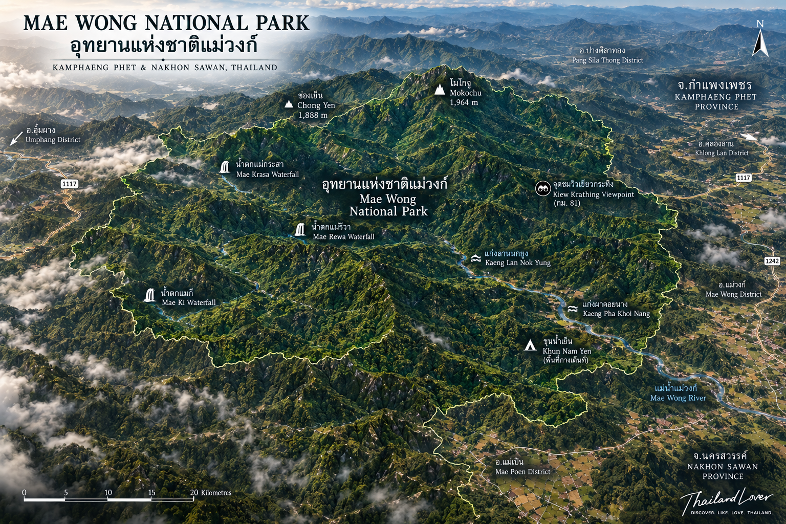
Most visitors meet only a thin edge of the park: Kiew Krathing, Khun Nam Yen, Chong Yen, Lan Nok Yung, camping, short forest trails. Deeper in, the landscape changes character — high mountains, headwater forest, waterfalls, wildlife corridors, remote ridges, caves and rock, habitat for large mammals. Mokoju stands at the centre of that wilderness, not at the centre of the car park.
The terrain is the western interior: ridges rising and falling into valleys and streams. Lower forest is seasonal. Higher slopes are cooler and wetter. The upper ridges change again. One protected area holds a mosaic, which is why the wildlife list is so long.
Mokoju, the Roof
โมโกจู · about 1,964 m · 32 km · 5 days / 4 nights
If one mountain defines the park’s reputation, it is Mokoju. The Department of National Parks describes it as the highest mountain in Mae Wong and one of the major high peaks of the surrounding region. It is also one of the highest summits in Thailand’s lower north. Cold, remote, exposed, and difficult to reach. That character is certain.
The name sits in the local Karen landscape and is often linked to a place of snow or ice that “never melts,” a way of speaking about how cold the summit feels. Secondary sources disagree on the exact wording. ThailandLover does not treat a speculative literal translation as established etymology.
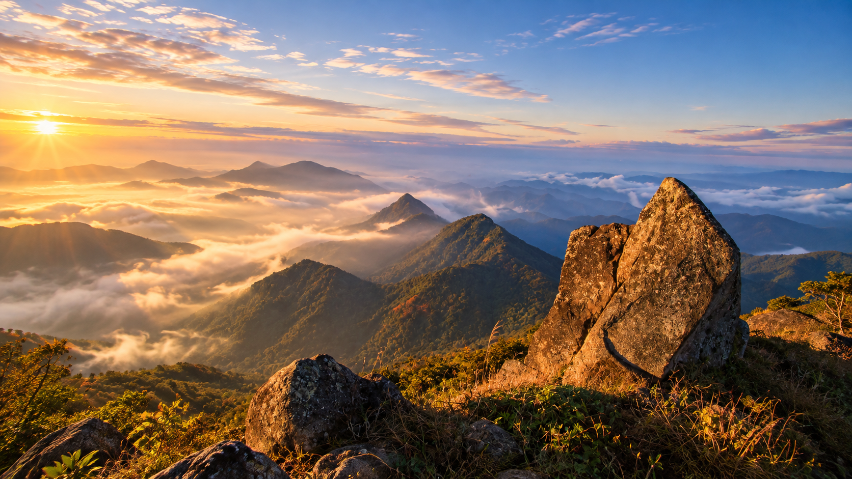
A Mokoju expedition is a temporary entry into a wilderness system. The forest is the road. The campsite is the hotel. The sky is the ceiling. On a clear morning the ridges stack toward the horizon and mist sits in the valleys. Cloud can also erase the view in minutes. Trees appear out of fog. Sound comes strangely close. Many people remember the mist as clearly as the summit. Weather is not a guarantee. This is a wilderness mountain, not a viewing platform.
The difficulty is remoteness and endurance, not technical climbing. You walk for days. There is no convenient road back to the car. Medical evacuation is not a city hospital. That is why access is controlled. Do not underestimate the mountain because it sits below 2,000 metres.
The River the Forest Holds
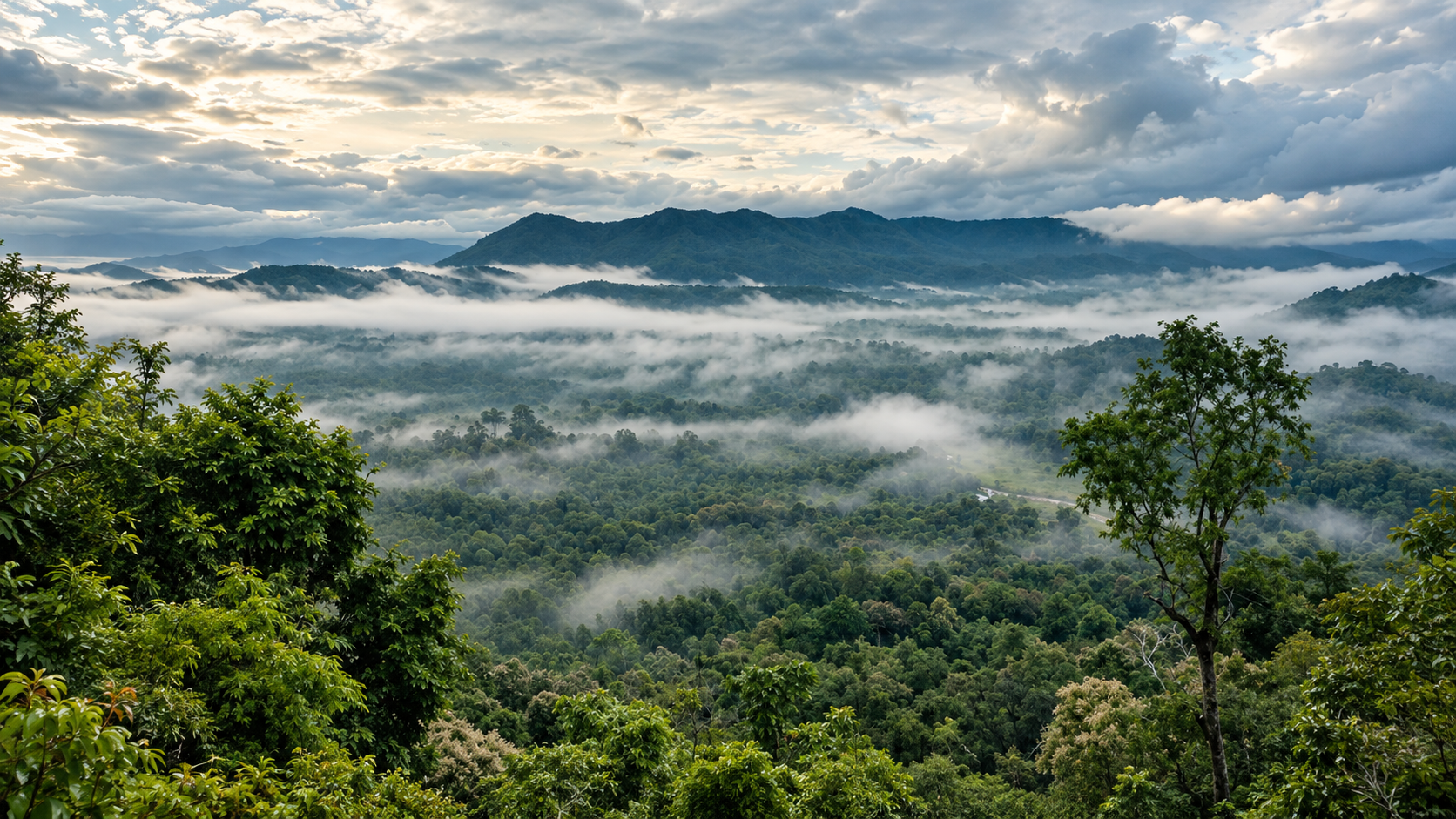
Mae Wong’s most important ecological job is as a watershed. The mountains throw off streams. Those streams become the Mae Wong River, which runs toward the lower plains of Nakhon Sawan and matters to communities, agriculture, freshwater life and wildlife. The forest is not a scenic backdrop. It stores water, slows it, and releases it. Protecting the trees protects the river.
Lower and drier slopes hold mixed deciduous forest: leaves fall, grass turns gold, the woods open, then the rains close them again into dense green. Wetter ground stays evergreen — shaded, important for watershed, wildlife and connectivity. Higher up, around Mokoju and Chong Yen, the forest feels like another country. Pine on exposed ridges, with cool air, is one of the park’s most distinctive pictures, especially in the cool season.
The Accessible Mountain
- Chong Yen · ช่องเย็น
- The name is close to “cool channel,” and it fits. High on the mountain road, colder than the lower park, known for mist, forest, birds and camping. DNP highlights species such as Burmese Yuhina, Coral-billed Scimitar Babbler, Long-tailed Sibia and Rufous-necked Hornbill. Arrive early. Sightings are never guaranteed.
- Kiew Krathing · กิ่วกระทิง
- One of the easiest ways to see the mountain without a multi-day trek. Commonly identified around kilometre 81 on the park road. Strongest in early morning, late afternoon, cool season and mist. Suitable for sunset, sunrise and a short walk — not a substitute for Mokoju.
- Khun Nam Yen · ขุนน้ำเย็น
- “Source of cool water.” Streams, forest, camping, morning mist. When conditions align, the valleys disappear under cloud while the campsite stays above it. The most accessible version of Mae Wong’s sea of mist. Still weather, not a timetable.
- Lan Nok Yung · ลานนกยูง
- Forest, streams, camping, cycling and nature trails — a lower-intensity way to be in the park without an expedition. Nearby, Kaeng Lan Nok Yung and Kaeng Pha Koi Nang are intimate rock-and-water landscapes, best when levels are moderate, not the giant falls deeper in.
The Rufous-necked Hornbill is one of the park’s special birds: globally threatened, tied to intact highland forest. Family groups still encountered around Chong Yen say something about the place. They do not say you will see one. DNP material reports more than 400 bird species from the wider landscape — a product of size, elevation, forest diversity and connection to the Western Forest Complex. For birdwatchers, Mae Wong is larger than its tourist profile.
Three Wilderness Waterfalls
These are not “drive, walk five minutes, photograph.” Access depends on season, permission, trail, weather and current rules. When the routes are open, they are for serious nature travellers.
- Mae Krasa · น้ำตกแม่กระสา · the giant
- A remote multi-tier fall deep in the forest. DNP descriptions give about 9 levels and a combined vertical descent of more than 1,000 metres. Not one plunge. A long sequence of cascades down the mountain.
- Mae Ki · น้ำตกแม่กี · the tall cascade
- Also about 9 levels, with a reported total height around 200 metres. Smaller than Mae Krasa. Still a significant wilderness fall.
- Mae Riwa · น้ำตกแม่รีวา · the scenic fall
- About 5 levels. The third is especially noted, a vertical drop of about 100 metres, in the rich forest of the Western Forest Complex. Vertical cascade, deep forest, remote location.
Together they show the scale of the park’s mountain hydrology: elevation, rain, forest and streams, each geological step becoming another cascade. In the rains they are at their most powerful, and that is also when many remote trails close for safety and recovery.
Why the Forest Matters
Mae Wong is part of the Western Forest Complex — WEFCOM, one of the most important wildlife landscapes in mainland Southeast Asia. It connects with Khlong Lan, Khlong Wang Chao, Huai Kha Khaeng and other protected forest. Large mammals cannot live on isolated islands. They need space, prey, breeding populations and corridors. Mae Wong is part of that system. With Khlong Lan it forms a northern component of more than 1,200 square kilometres, reaching toward one of Thailand’s most important tiger landscapes.
A tiger cannot survive alone. The forest also has to hold deer, wild boar, gaur, banteng and other prey. Presence is a proxy for the food web, not a souvenir. DNP research has documented at least 35 mammal species in tiger-monitoring studies here — a study list, not a complete inventory. Recorded animals include Asian elephant, tiger, leopard, clouded leopard, leopard cat, jungle cat, dhole, golden jackal, Asiatic black bear, sun bear, civets, gaur, banteng, sambar, barking deer, wild boar, serow and smaller mammals.
Gaur and banteng shape the vegetation as well as feeding predators. One of the more encouraging stories is evidence, from DNP research, of wild cattle re-establishing territory in Mae Wong after a long absence. Elephants, where they occur in the wider forest, open trails, disperse seeds and change structure. Leopards and clouded leopards are here and almost never seen. The fact of them matters more than a photograph.
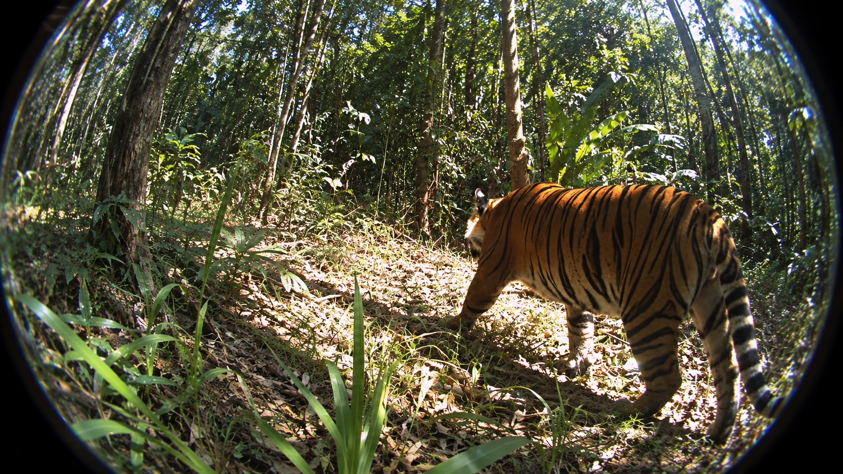
Camera-trap research has recorded adult tigers across the park, and reproduction. One published study recorded 14 adult tigers — 6 males and 8 females — and 2 cubs in the surveyed area at that time. A wider northern Western Forest assessment recorded 16–21 tigers across Mae Wong, Khlong Lan, Khlong Wang Chao, Umphang and connected forest. DNP research has also recorded movement between Mae Wong and neighbouring forest. These are research-period figures, not a 2026 census. They show habitat, not a headcount you can book.
In March 2026, DNP reported a tiger moving outside the protected-area boundary into nearby agricultural and community land. The animal, known as Tiger Pin, was eventually captured for safety and rehabilitation. This is not a tourist attraction. It is a reminder that wildlife does not read a park line on a map. Landscape-scale conservation is the point.
Birds worth naming, beyond the Chong Yen list, include Blue-winged Minla, Long-tailed Green Sunbird, Black Eagle, Red-bellied Eagle and Pin-tailed Green Pigeon — an altitudinal range, not a checklist you will clear in an afternoon. Botanically, DNP material associates a locally distinctive plant, Mahaporn Mae Wong or Pahnan Mae Wong, with this forest specifically. Higher zones also sit near the southern edge of some plants linked to cooler, Himalayan-associated environments. The mountains act as a transition. That is why species uncommon in lower Thailand can occur here. Do not expect to identify them from the road.
When the Forest Changes
- November – February · the great season
- Trekking, Mokoju, the remote falls, camping, mist, birds, mountain light. DNP has traditionally opened the long routes in this window. ThailandLover rating: excellent.
- March – May · hot and dry
- Kiew Krathing and other accessible places can still work. Haze, wildfire risk, heat and seasonal closure can hollow the trip out. Early morning is the better hour for photographs.
- June – October · green and wild
- The forest is lush, falls are powerful, moss and mist increase, trails turn to mud. Long-distance attractions are generally closed. Rain also means landslides, fallen trees and road hazards.
Mist is most reliable in the cool months around Khun Nam Yen, Chong Yen, the high ridges and Mokoju. There is no guaranteed sea-of-mist schedule. Dry-season fire can open the understory, kill young trees, and damage both air and watershed. Visitors never start an uncontrolled fire. A small campfire is enough, in the wrong week.
Who It Is For
Camping is one of the better ways to understand the elevation. Lan Nok Yung is the more accessible ground. Khun Nam Yen is cooler and more mountainous. Chong Yen is higher, colder, and the one birdwatchers should consider — quiet forest at night, mist in the valleys at dawn. Confirm availability for the exact date. Seasonal management moves.
Families and couples
Design a family day around Kiew Krathing, Khun Nam Yen, Lan Nok Yung and short trails. Do not take a casual family onto Mokoju or the remote falls unless the group already treks for days. Couples who want camping, sunrise, mist and a mountain road — space and silence, not restaurants — are in the right park.
Photographers and hikers
Layers at Kiew Krathing. Mist at Khun Nam Yen. Pine and birds at Chong Yen. Waterfalls only when officially open. Wildlife only at an ethical distance; in research, the camera trap is the honest tool. Night sky when weather and moonlight cooperate. Hikers: prepare shoes, pack, sleep system, warm layers, rain kit, food, water, headlamp, first aid, navigation, power and a way to carry rubbish out.
Getting There
The main visitor approach is through Kamphaeng Phet. A commonly described route from Nakhon Sawan runs Highway 1 to Khlong Khlung, then Highways 1242 and 1072 to the Khlong Lan junction, then Highway 1117 into the park. DNP descriptions place headquarters about 19 km beyond that junction. The park pairs naturally with Kamphaeng Phet, Khlong Lan — large, more accessible waterfalls beside Mae Wong’s mountains and Mokoju — and Khlong Wang Chao.
From Nakhon Sawan the same forest can sit beside Mae Poen, Mae Wong District and the central-northern countryside, including Bueng Boraphet. The road is more rural and less developed. That is part of the character, not a missing resort.
Do not expect a luxury stay, a zoo, a drive to Mokoju, a one-day trek of the major peaks, a guaranteed sea of mist, guaranteed animals, or every attraction open all year. The wildness is the asset. Communities live around the boundary. Agriculture occupies the surrounding valleys. Fire, hunting, wildlife conflict, restoration and water are shared problems. Conservation here is cooperation, not a fence in the abstract.
ThailandLover Journeys
- One day · do not attempt Mokoju
- Kiew Krathing, Khun Nam Yen, Chong Yen and Lan Nok Yung. The essence, without pretending an expedition fits before dinner.
- Two days · the accessible wilderness
- Kamphaeng Phet into the park, Kiew Krathing, Khun Nam Yen, sunset and camp. Next morning, mist or birds, Chong Yen, forest trails, Lan Nok Yung, then out.
- Three days · still not the remote falls
- Viewpoints, camping, birds, forest walks and the neighbouring western parks. Mae Krasa, Mae Ki, Mae Riwa and Mokoju still need their own windows.
- Five days · Mokoju, if it is open
- A long forest approach and camp; deeper mountain and camp; highland and the summit area; return through the forest; final descent to headquarters. The exact line follows the current official route, group logistics and park rules — not this paragraph.
Before you leave, check opening status, seasonal closures, Mokoju registration, trek dates, weather, roads, camping, wildfire and PM2.5, water, safety instructions and fees. In the latest published DNP schedule, Mae Wong is Group 2: Thai adults 40 baht, children 20 baht; foreign adults 200 baht, children 100 baht. Categories change. Read the current notice.
ThailandLover Editorial Verdict
- Wilderness
- The identity of the park, not a side trail.
- Biodiversity
- Elevation, forest types and a connected complex.
- Wildlife conservation
- Tiger habitat and prey recovery. Not a safari.
- Mountain landscape
- Ridges, mist and highland forest.
- Mokoju
- One of Thailand’s serious wilderness treks.
- Waterfalls
- Remote, seasonal, and on a different scale.
- Birdwatching
- Chong Yen, and more than 400 species reported.
- Photography
- Mist, pine, falls, forest, night sky.
- Camping
- Three different elevations. Confirm the date.
- Accessibility
- The road is reachable. The wilderness is not casual.
- Infrastructure
- Enough to enter the forest. Not a resort.
- Family access
- Good if the day stays on the accessible side.
- Overall
- More important than its visitor numbers suggest.
Best for: serious nature travellers, trekkers, birdwatchers, wildlife enthusiasts, landscape photographers, campers, mountain lovers, and anyone interested in conservation.
Not ideal for: luxury, quick roadside attractions, people uncomfortable with remote wilderness, travellers expecting guaranteed animals, or anyone who wants to reach the major waterfalls by car.
Frequently Asked Questions
- Is Mae Wong officially a national park?
- Yes. It was declared on 14 September 1987 and is Thailand’s 54th national park. About 558,750 rai / 894 km², across Pang Sila Thong in Kamphaeng Phet, and Mae Wong and Mae Poen in Nakhon Sawan.
- How hard is Mokoju?
- DNP describes about 32 kilometres and at least 5 days / 4 nights. Summit about 1,964 m. No road to the top. Fitness, camping kit, registration and current staff or guide rules are required. It is not a day hike.
- Can I see a tiger?
- No. There is no tourist tiger viewing. Research has recorded tigers, including one historical survey of 14 adults and 2 cubs, and a wider count of 16–21 in connected northern forest. Those are research-period figures, not a 2026 census. Do not search for them.
- Are the remote trails open all year?
- No. Previous schedules have opened Mokoju and the three great falls from about 1 November to 28 February. Other years have listed longer closures. The park can stay open for viewpoints and camping. TAT’s 2026 guidance says dates are reviewed annually. Check DNP before you book.
- When should I go, and what is the fee?
- November to February is the strongest general window. The latest published DNP schedule places Mae Wong in Group 2: Thai adults 40 baht, children 20 baht; foreign adults 200 baht, children 100 baht. Confirm the current notice, and check fire, air and roads.
The Western Forest Beside It
- Khlong Lan National Park
- Adjacent forest, and the place to add large accessible waterfalls to a Mae Wong mountain trip.
- Khlong Wang Chao National Park
- Falls, forest and mountain trails in the same western system.
- Mae Wang National Park
- A different Chiang Mai story — geology and Pha Chor — if the road turns north.
- Khao Yai National Park
- Another forest still large enough that wildlife, not the viewpoint, is the reason it exists.
Location
Find Mae Wong
Pang Sila Thong, Kamphaeng Phet · the park continues into Mae Wong and Mae Poen, Nakhon Sawan