

Marine National Park · Krabi
Mu Ko Lanta National Park
อุทยานแห่งชาติหมู่เกาะลันตา
Where the Andaman Becomes More Than a Beach
Ko Lanta · Krabi · Andaman Sea
Forest, islands, coral reefs and Andaman culture in one protected landscape — 25 islands, a white lighthouse at the end of Ko Lanta Yai, and a story about seashells that is larger than it looks.
Beyond the Beach
Some places are not beautiful because of a single beach. They are beautiful because forest, mountain, coast, islands, reef, the underwater world and people share one landscape.
Mu Ko Lanta National Park — อุทยานแห่งชาติหมู่เกาะลันตา is one of those places.
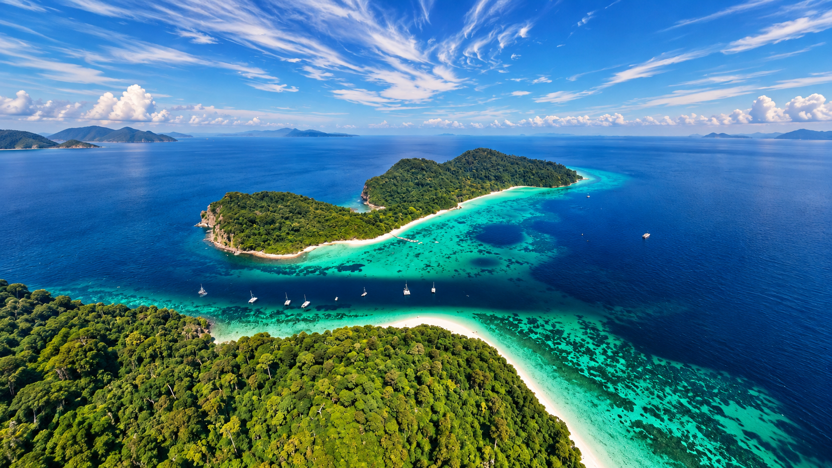
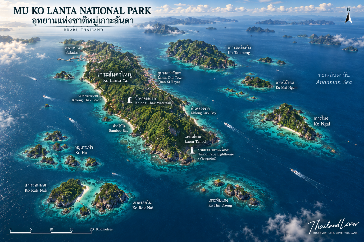
It sits in Krabi, on Thailand’s Andaman coast, covering about 134 square kilometres, or 83,750 rai. It holds 25 islands in four groups: Mu Ko Rok, Mu Ko Ha, Mu Ko Ngai and Mu Ko Lanta.
The terrain runs from island forest and beach forest through mangrove to coral reef and open sea. Look one layer deeper, and this is not only a destination for people who love the water. It is a place where nature, conservation, travel and Andaman coastal culture meet.
Quick Facts
- Official Name
- Mu Ko Lanta National Park
- Thai Name
- อุทยานแห่งชาติหมู่เกาะลันตา
- Province
- Krabi
- District
- Ko Lanta
- Sea
- Andaman Sea
- Area
- About 134 km² / 83,750 rai
- Established
- 15 August 1990
- Islands
- 25 islands in 4 groups
- Island Groups
- Mu Ko Rok, Mu Ko Ha / Tukon Lima, Mu Ko Ngai, Mu Ko Lanta
- Headquarters
- Laem Tanod, southern Ko Lanta Yai
- Signature Landmark
- Laem Tanod Lighthouse
- Signature Conservation Story
- Hermit Crab Homecoming
- Key Places
- Laem Tanod, Ko Rok, Ko Ha, Ko Ngai, Ko Talabeng
Why Mu Ko Lanta?
ทำไมหมู่เกาะลันตาจึงน่าสนใจ
“Lanta” often means Ko Lanta Yai: west-coast hotels, restaurants, sunsets and a slower stay. Mu Ko Lanta National Park is a wider story.
The 25 islands range from a large forested mountain island to small limestone stacks, beaches, reefs and open water. The park can be read as one sequence:
Forest → Mangrove → Beach → Island → Coral Reef → Open Sea
That is why it should not be told only as “Krabi’s pretty sea.” It is one of the Andaman’s more varied natural landscapes.
Is Mu Ko Lanta the Same as Ko Lanta?
No — not entirely. Ko Lanta is a wider destination. Mu Ko Lanta National Park is a legally defined protected area.
Ko Lanta Yai is not a national park from end to end. Resorts, restaurants and popular beaches on the north and west sit outside the park. The best-known park ground on Ko Lanta Yai is the south, especially Laem Tanod.
- Ko Lanta
- Hotels, resorts, beaches, restaurants, local life, Old Town, wellness and long stays.
- Mu Ko Lanta National Park
- Protected nature, islands, coral reefs, wildlife, forest, beaches, diving, snorkelling and conservation.
Keeping the two entities distinct is better for travellers — and for how search engines understand the place. They still belong together as a destination.
A Marine National Park of Krabi
The park lies in Ko Lanta District, in the Andaman Sea. About 134 square kilometres include land and sea. Wetland and environment-policy material describes sand beaches, pebble shore, mangrove, coral, coastline, islands, forest and marine ecosystems. The conservation value is larger than a beach destination.
25 Islands. Four Island Worlds.
Mu Ko Lanta National Park consists of 25 islands, grouped by geography.
- 01 — Mu Ko Rok
- Ko Rok Nok (เกาะรอกนอก) and Ko Rok Nai (เกาะรอกใน).
- 02 — Mu Ko Ha / Tukon Lima & Hin Daeng
- Five small islands — some with a little plateau, some little more than rock above the sea. A renowned dive area. Hin Daeng and Hin Muang nearby are underwater pinnacles, not landing islands.
- 03 — Mu Ko Ngai
- Ko Ngai (เกาะไหง) and Ko Ma (เกาะม้า). A long east-coast beach on Ko Ngai; west and north are mountain. Ko Ma is rock with almost no flat land.
- 04 — Mu Ko Lanta
- The largest group: 16 islands, including Ko Lanta Yai, Ko Talabeng, Ko Mai Ngam, Ko Mai Ngam Tai, Ko Ra Pu Phang, Ko La Pu Le and others. Ko Lanta Yai is steep, complex hill country.
The Geography of Ko Lanta Yai
เกาะลันตาใหญ่ไม่ได้ราบเรียบอย่างที่เห็นจากชายหาด
The usual picture of Ko Lanta Yai is the west-coast beach. Inland, the island is different. Most of the land slopes more than 35 percent; some central ground is steeper than 50 percent. Height rises from the shore to a summit of about 488 metres above sea level. Flatter land is more common on the beaches, especially in the south.
Coastal Lanta and mountainous Lanta.
Laem Tanod
แหลมโตนด · Landmark, viewpoint and park headquarters
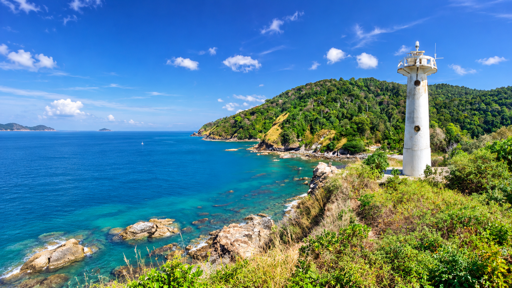
The first place to know in the park is Laem Tanod, at the southern tip of Ko Lanta Yai — home to Mu Ko Lanta National Park Headquarters.
The cape reaches into the Andaman. Beaches sit on two sides. Coastal forest remains. The strongest image is the white lighthouse at the point: landmark, viewpoint and symbol of the park at once. From here you see the Andaman and surrounding islands.
Ta Nod Beach
หาดโตนด
One side of the cape is a natural park beach. Water colour changes with season, swell, light and weather. What matters is not only the colour. It is the feeling of being at the end of the island: sea in front, forest behind, a white lighthouse on the point.
Nature Trail
Forest-to-coast, not only a beach stroll
Headquarters has a nature trail into forest and shore. The tip of the island is not only sand. Coastal plants, forest, rock and cape geography sit together. ThailandLover treats this as a forest-to-coast experience, separate from “beach.”
Ko Rok
เกาะรอก · Jewel of the Andaman
If Laem Tanod is the park’s image on Ko Lanta Yai, Ko Rok is one of its underwater images. The pair is Ko Rok Nok and Ko Rok Nai, close together with a channel between them. Fine sand, clear water and reef surround the islands.
Travel here is about snorkelling, scuba diving, swimming, beach walking and nature photography. Tourism Authority of Thailand presents Ko Rok Nok and Ko Rok Nai as a place to dive and see coral between the two islands.
Ko Rok Nai
A mountain island of cliffs and eroded shore. The highest point is about 208 metres. The west is a long cliff. This is limestone and rock, forest, beach and sea together — not a flat tropical postcard.
Ko Rok Nok
Similar in size, with a summit of about 156 metres. Some flatter ground between the hills links to beach and bay. It is popular as a day trip from Ko Lanta in the tourist season. The real reason divers come is still underwater.
Ko Ha
หมู่เกาะห้า · Five islands above, another world below
Mu Ko Ha — also Tukon Lima — is a group of five small islands. The name comes from that count. Some have a little plateau. Some are rock above the sea. From a boat they read as limestone islands scattered on open water. The real interest is underneath.
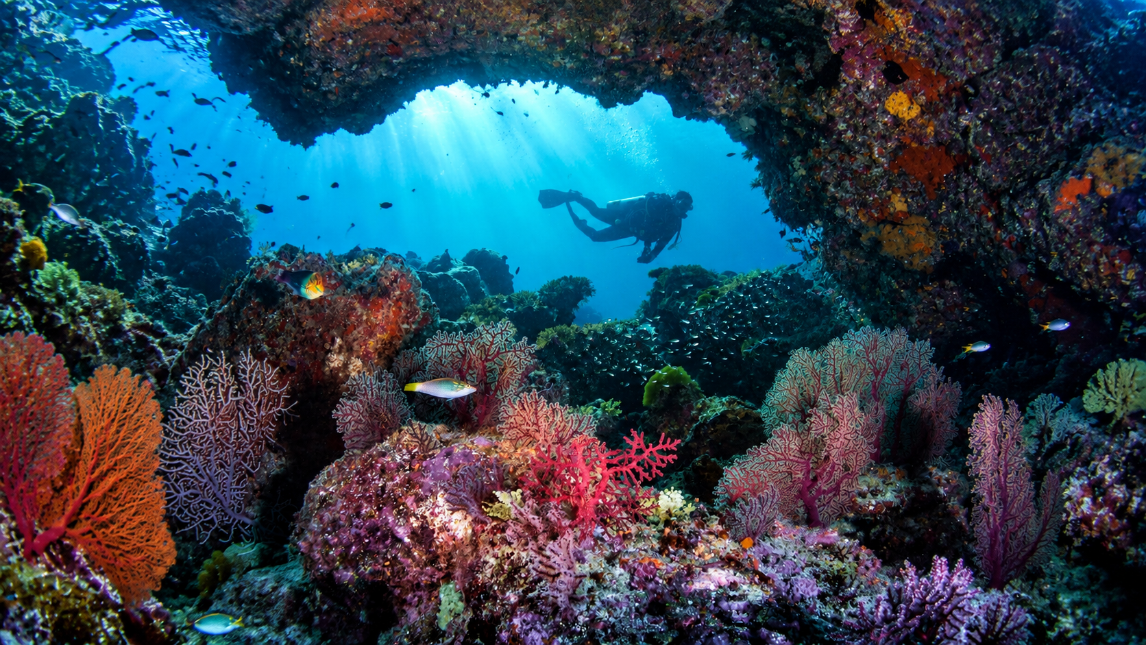
Ko Ha is a noted Andaman dive area. Divers may find hard and soft corals, sea fans, anemones, reef fish, nudibranchs, sea turtles, moray eels, seahorses and other marine life. Some sites have caves and gaps under limestone. Actual conditions depend on season, current and visibility. No species should be promised on every trip.
Above the water — dramatic limestone islands. Below the water — coral reefs, caves and marine life.
Water between the rocks can look like a lagoon. From the surface you see limestone around blue sea. For divers, that water opens into another layer. It is one of the park’s signature experiences.
Hin Daeng & Hin Muang
A world-class diving area associated with Mu Ko Lanta
Hin Daeng–Hin Muang is among the Andaman’s famous deeper dive sites, often mentioned with Lanta diving. Soft-coral colour and underwater pinnacles define it. It is better for experienced divers than for a general sea trip: open sea, current and conditions matter.
ThailandLover does not describe Hin Daeng and Hin Muang as islands of Mu Ko Lanta National Park. Geographically they are underwater pinnacles / dive sites, not islands you land on. The better line is: a world-class diving area associated with the marine landscape of Mu Ko Lanta.
Ko Ngai and Ko Ma
Ko Ngai
เกาะไหง
The east coast of Ko Ngai has a long beach. West and north are steep mountain, with a summit of about 198 metres. Beach and reef make it suitable for rest and water time. Resorts and a visitor community sit on the island, so its character is different from Ko Rok, which feels more purely natural.
Ko Ma
เกาะม้า
A small rock island with no large flat ground. In landscape photography it is a natural formation against water and horizon.
Ko Talabeng
เกาะตะละเบ็ง · Limestone, sea, caves, kayaking
Ko Talabeng sits east of Ko Lanta Yai. The land is limestone mountain and steep cliff. Some of the shore has sea-level caves. It suits boat travel and sea kayaking when weather and licensed operators allow. This is not a lie-on-the-sand island. It is limestone + sea + caves + kayaking.
Mangrove, Mai Ngam and Forest to Sea
West-coast beaches are what most people picture. The Lanta group also has important mangrove, especially on islands and the eastern shore. Mangrove is a nursery, a food source, shelter, a coastal buffer and the link between land and sea.
Ko Mai Ngam and Ko Mai Ngam Tai belong to the Lanta group. Their character is alluvial and estuarine sediment and mangrove flats — a different geography from limestone islands such as Ko Ha and Ko Talabeng. That ground matters for coastal wetlands.
- Terrestrial forest
- Island woodland on the hills.
- Beach forest
- The coastal fringe.
- Mangrove
- Brackish water and nursery habitat.
- Coral reef
- The living structure of the shallows.
- Open Andaman Sea
- The wider marine system.
Protecting one layer protects the next. If the coast declines, mangrove feels it. If reef declines, the marine system changes. If beaches are used without care, coastal animals follow.
The Hermit Crab Homecoming
Return Homes. Restore Life. Regenerate Ecosystems.
One of the most interesting present-day stories of Mu Ko Lanta National Park is not the most beautiful beach. It is the hermit crab.
Hermit crabs live in empty shells. As they grow they need larger ones. When people take shells home as souvenirs, what looks like an empty shell may be a future home.
The park developed a restoration project to ease the shortage of natural shells: “Return Homes, Restore Life, Regenerate Ecosystems – Regenerative Tourism for the Future.” Shells are returned to the ecosystem as hermit-crab housing.
Thai government figures describe more than 12,000 donated shells, about 700 kilograms, with reports of recovering crab numbers and healthier beaches. The project was recognised internationally as a Green Destinations Top 100 Story 2025.
That is why ThailandLover gives this story space. Responsible travel stops being a slogan and becomes something you can see.
Take photos. Leave shells. Leave wildlife where it belongs.
One shell in one hand looks like nothing. Thousands of visitors doing the same thing adds up. Hermit crabs cannot grow their own shells. When natural shells vanish, they may use bottle caps and other waste instead.
Marine Life and Coral Reefs
Park waters are rich, especially around reef and dive sites. Life associated with the ecosystem includes reef fish, butterflyfish, angelfish, clownfish, moray eels, sea turtles, sea fans, soft and hard corals, sea anemones, nudibranchs, seahorses and other species.
In deeper Andaman water, whale sharks and manta rays may be encountered. Sightings are nature, not a product. ThailandLover uses “may encounter” / “possible sightings” — never “you will see.”
Coral is habitat, food, nursery, shelter and a natural coastal buffer. It is also why Ko Rok and Ko Ha draw divers from far away. Andaman reefs are not above climate. Rising sea temperature can cause coral bleaching, when coral loses the algae that give it colour. Clear water and bright reef are not things to treat as permanent. Responsible marine travel is part of keeping those systems.
People of Lanta
ชาวเลอูรักลาโว้ย · A living island community
Ko Lanta has a complex social history. It is home to the Urak Lawoi' (อูรักลาโว้ย), one of the indigenous sea peoples of the Andaman. Traditional life is bound to the sea: fishing, travel and cultural belief. Thai, Chinese and Muslim communities have also lived here for a long time.
That mix is part of Lanta’s character. This is not only an island destination. It is a living island community.
Lanta Old Town
Lanta Old Town, on the east of Ko Lanta Yai, reflects coastal community and sea trade. Old wooden houses and buildings over the water are the signature. It is not inside Mu Ko Lanta National Park. It is still a cultural destination worth linking, because travellers understand the island better when they see nature + community + history.
What to Do
Experiences at Mu Ko Lanta National Park
- 01 — Visit Laem Tanod
- Lighthouse, beach and the view from the end of the island.
- 02 — Walk the nature trail
- Forest-to-coast at park headquarters.
- 03 — Snorkel at Ko Rok
- Reef and beaches between Ko Rok Nok and Ko Rok Nai.
- 04 — Dive Ko Ha
- Limestone above, coral, caves and marine life below.
- 05 — Explore Ko Talabeng
- Kayak or boat among limestone and sea caves with a licensed operator, subject to the sea.
- 06 — Discover Ko Ngai
- Beach rest and underwater time, with a more inhabited island character.
- 07 — Explore the mangroves
- The eastern side of the Lanta group, a different ecosystem from the west-coast beach.
- 08 — Learn the hermit crab story
- Why one shell on a beach is not “empty.”
- 09 — Photograph the lighthouse
- Laem Tanod’s white tower is one of the park’s landmarks.
- 10 — Discover Lanta beyond the beach
- Connect the park with community, Old Town, food and island culture.
When to Visit
Thailand’s Andaman coast follows the monsoon. The usual tourist season is when the sea is better for marine activity — especially trips to Ko Rok, Ko Ha, Ko Ngai and dive sites.
The actual travel day should still be checked for swell, wind, rain, island openings, dive-route openings and park announcements. Status can change with season and weather.
Some islands and marine areas are limited or closed at times of year so nature can recover, and for safety in rough seas — especially offshore places such as Ko Rok and dive sites.
Check current park status before travelling.
How to Get There
From Krabi, travellers generally reach Ko Lanta Yai via Ko Lanta Noi. On Ko Lanta Yai, the road south leads to Laem Tanod and park headquarters.
Ko Rok, Ko Ha and other dive sites require a boat. Time at sea depends on pier, boat type, sea state, route and weather. ThailandLover does not lock a crossing time without those details.
A common route from the airport is:
Krabi Airport → mainland pier / ferry → Ko Lanta Noi → Siri Lanta Bridge → Ko Lanta Yai → Laem Tanod
Trips to Ko Rok or Ko Ha can be arranged from Ko Lanta Yai by speedboat or tour boat in the season those programmes run.
Responsible Travel
- Do not take shells — especially where hermit crabs live
- Do not stand on, touch or break coral
- Do not feed marine life or wildlife
- Keep your distance from turtles, dolphins, whale sharks, manta rays and other animals
- Reduce single-use plastic; carry a reusable bottle
- Leave no trace — what you bring in, take out
Leave nothing but footprints.
Frequently Asked Questions
- What is Mu Ko Lanta National Park?
- A protected marine and coastal landscape in Ko Lanta District, Krabi, covering about 134 square kilometres and 25 islands in four groups.
- When was it established?
- 15 August 1990.
- How many islands are in the park?
- 25 islands in Mu Ko Rok, Mu Ko Ha, Mu Ko Ngai and Mu Ko Lanta.
- Is all of Ko Lanta part of the national park?
- No. The park protects defined areas within the wider destination. The best-known park ground on Ko Lanta Yai is the south around Laem Tanod.
- Where is headquarters?
- Laem Tanod, at the southern end of Ko Lanta Yai.
- What is Laem Tanod famous for?
- Headquarters, coastal nature, beach, viewpoint and the white lighthouse.
- Are Ko Rok, Ko Ha, Ko Ngai and Ko Talabeng in the park?
- Yes. Ko Rok is Ko Rok Nok and Ko Rok Nai. Ko Ha is also called Tukon Lima. Ko Ngai and Ko Ma form the Ngai group. Ko Talabeng belongs to the Lanta group.
- Can you dive and snorkel?
- Yes. Ko Rok and Ko Ha are principal areas. Some offshore sites suit experienced divers. Visibility at Ko Rok varies with weather, sea and season.
- Can you see whale sharks?
- They may be encountered in the wider Andaman diving area. Sightings are unpredictable — a possible wildlife encounter, not a guaranteed attraction.
- Why are hermit crabs important here?
- They need empty shells as homes. Collecting shells as souvenirs reduces shelter. The park’s Homecoming project returns shells to the beach.
- What is the Hermit Crab Homecoming project?
- A regenerative tourism initiative that has involved more than 12,000 donated shells and was recognised as a Green Destinations Top 100 Story in 2025.
- Can visitors collect shells?
- They should not. On Lanta, a shell can be a hermit crab’s next house.
- Is Lanta Old Town inside the park?
- No. It is a separate cultural destination on Ko Lanta Yai, worth visiting alongside the park.
- What makes the park special?
- Forest + mangrove + beach + islands + coral reefs + open sea + wildlife + culture in one protected landscape.
Related Destinations
- Hat Noppharat Thara–Mu Ko Phi Phi
- Krabi’s other great Andaman marine park — Maya Bay, Pileh and a different limestone fame.
- Ao Phang Nga National Park
- Limestone islands, hidden lagoons and mangrove north of Krabi.
- Khao Phanom Bencha National Park
- Krabi’s mountain rainforest — the inland counterpart to Lanta’s sea.
- Hat Chao Mai National Park
- Trang’s Andaman islands, Emerald Cave and seagrass further down the coast.
- Beach & Islands
- Ko Lanta as a stay — hotels, west-coast beaches and island life beyond the park boundary.
Location
Find Mu Ko Lanta National Park
Laem Tanod, Ko Lanta Yai, Ko Lanta, Krabi