

Marine National Park · Krabi
Hat Noppharat Thara–Mu Ko Phi Phi National Park
อุทยานแห่งชาติหาดนพรัตน์ธารา–หมู่เกาะพีพี
Where Limestone Islands Rise from the Andaman Sea
Krabi · Southern Thailand · Andaman Sea
Maya Bay, Phi Phi Leh, Poda and Noppharat Thara Beach — a connected marine landscape of cliffs, lagoons and reefs, and one of Thailand’s most intensively managed protected coasts.
A Landscape Too Famous to Treat Lightly
Few landscapes capture the imagination of the Andaman coast quite like Hat Noppharat Thara–Mu Ko Phi Phi National Park.
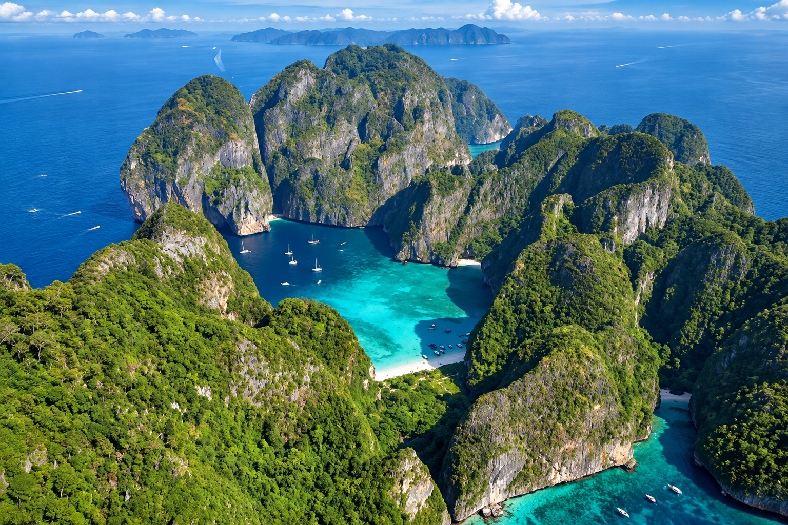
Here, the mainland coast of Krabi gives way to a spectacular marine landscape of limestone cliffs, forested islands, hidden lagoons, coral reefs, beaches and open blue water.
This is the protected landscape that contains some of Thailand’s most recognizable names: Maya Bay. Phi Phi Leh. Phi Phi Don. Poda Island. Tup Island. Noppharat Thara Beach.
Yet reducing the park to a collection of famous tourist attractions misses the larger story.
The national park protects a connected coastal and marine environment where limestone geology, beaches, reefs, seagrass, coastal forest, marine wildlife and island ecosystems exist together.
Its scenery is spectacular. Its geology is extraordinary. Its tourism pressure is immense.
And that last point is important. Hat Noppharat Thara–Mu Ko Phi Phi is one of Thailand’s most intensively visited marine protected landscapes. In recent years, park authorities have increasingly focused on carrying capacity, visitor management, zoning, mooring systems, rehabilitation and ecosystem protection.
Come for the islands. Stay long enough to understand why they need protection.
At a Glance
- Official Name
- Hat Noppharat Thara–Mu Ko Phi Phi National Park
- Thai Name
- อุทยานแห่งชาติหาดนพรัตน์ธารา–หมู่เกาะพีพี
- Province
- Krabi
- Region
- Southern Thailand
- Coast
- Andaman Sea
- Status
- National park, established 1983
- Park Character
- Marine and coastal national park
- Signature Landscapes
- Limestone islands, beaches, sea cliffs, lagoons, coral reefs and coastal forest
- Signature Destinations
- Maya Bay, Phi Phi Leh, Phi Phi Don, Noppharat Thara Beach and Ko Poda
- Main Gateway
- Ao Nang / Krabi mainland coast
The park has been formally established for decades and is actively managed by Thailand’s Department of National Parks, Wildlife and Plant Conservation (DNP). Recent DNP operations continue to cover visitor management, ecological protection and specific issues affecting park areas and marine resources.
The Geography
Hat Noppharat Thara–Mu Ko Phi Phi National Park lies along the Andaman coast of Krabi Province. Its landscape combines two strongly contrasting environments.
The Mainland
The mainland side includes Noppharat Thara Beach, coastal forest, limestone headlands, tidal and intertidal environments, visitor facilities, ranger stations and access points for marine excursions.
The Offshore Islands
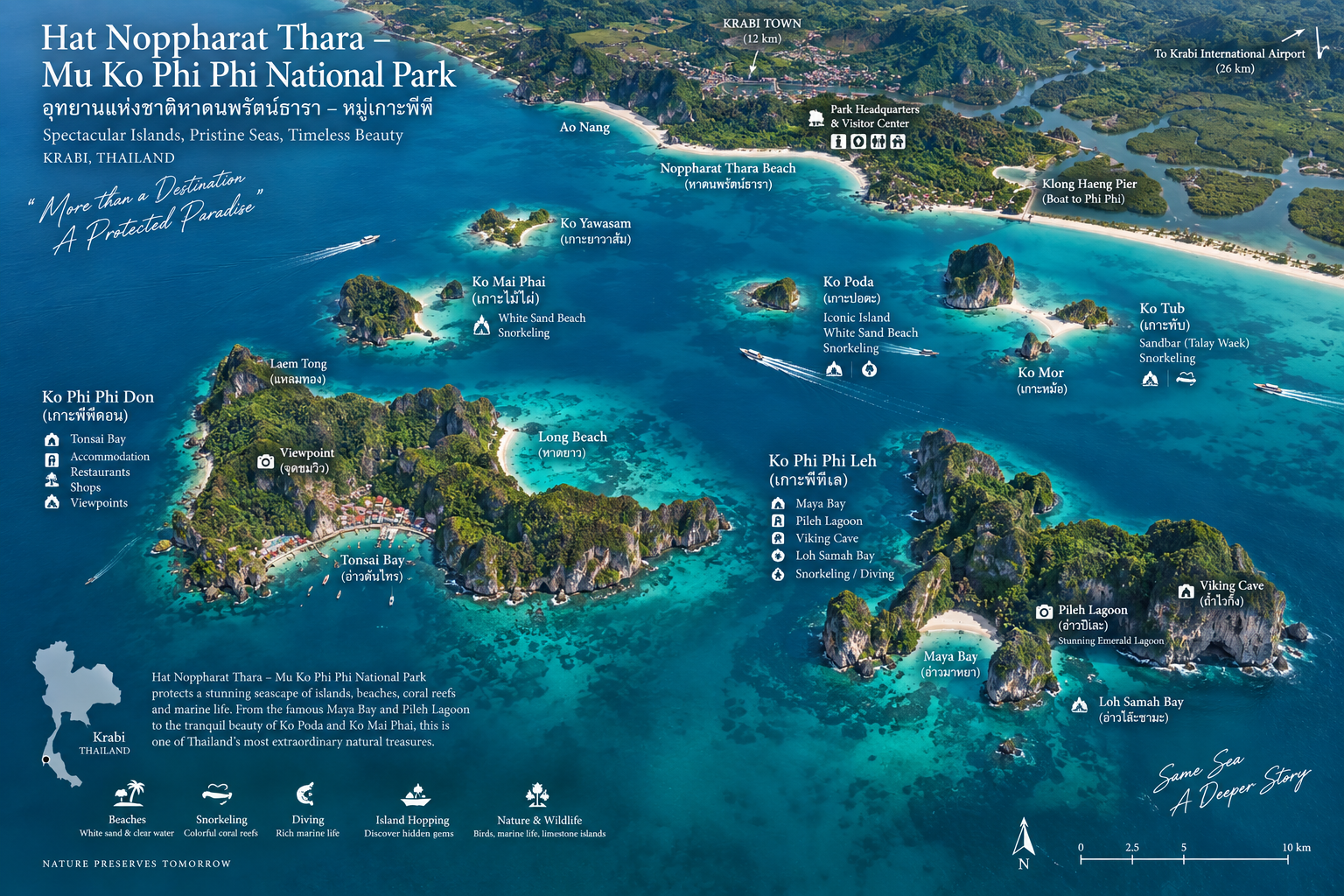
Farther offshore, the landscape becomes an archipelago of limestone islands. Among the best-known are Ko Phi Phi Don, Ko Phi Phi Leh, Ko Poda, Ko Tup, Ko Mor, Ko Mai Phai and Ko Yawasam.
The precise management status of individual islands, zones and access points can differ. ThailandLover does not assume that every visible island has identical visitor rules.
A Limestone World
The most defining geological feature of the park is limestone karst. The cliffs and islands of the Phi Phi area are the visible result of geological processes operating over very long periods.
Limestone formations have been uplifted, fractured, weathered, dissolved and eroded by water and waves. The result is a coastline of dramatic vertical walls, caves, bays and isolated islands.
This is why the Krabi–Phi Phi seascape looks so different from a conventional sandy coast. Here the geology controls the geography.
Many of the islands appear almost vertical. Steep limestone walls rise directly from the sea. Forest occupies the tops and slopes. Sea caves cut into the rock. Beaches appear where erosion and sheltered coastal conditions permit sediment to accumulate.
White sand · Turquoise water · Dark green forest · Pale limestone
This visual combination has become one of the defining images of Thailand.
Noppharat Thara Beach
The Mainland Face of the Park
Noppharat Thara Beach is one of the principal mainland landscapes associated with the national park. The beach is long, relatively open and backed by coastal vegetation.
At low tide, exposed sandbars and shallow areas can significantly change the appearance of the coastline. Offshore limestone islands are visible from the beach.
This gives Noppharat Thara a useful perspective that visitors sometimes miss when they go directly offshore: the islands are part of a larger coastal landscape.
Ao Nang
The Gateway
Ao Nang is not itself synonymous with the national park, but it is one of the major tourism gateways to the park’s island destinations. The town functions as a base for visitors heading toward Railay, Phra Nang, Poda, Tup, Phi Phi and other nearby marine destinations.
The relationship between Ao Nang and the national park is therefore primarily one of access and tourism infrastructure.
Ao Nang is the gateway. The park is the protected landscape beyond it.
Ko Phi Phi Don
The Inhabited Island
Ko Phi Phi Don is the largest island in the Phi Phi group and the principal inhabited island. It is also the main commercial and visitor centre of the archipelago: hotels, guesthouses, restaurants, shops, boat services, diving operators, viewpoints, beaches and local communities.
This makes Phi Phi Don fundamentally different from Phi Phi Leh.
- Phi Phi Don
- Inhabited. Developed. Commercial.
- Phi Phi Leh
- Uninhabited. Protected. Iconic.
That contrast is essential to understanding the Phi Phi landscape.
Ton Sai Bay
Ton Sai is one of Phi Phi Don’s principal bays and the centre of marine access to the island. Ferries, longtail boats and other vessels use the area as a transportation hub. It is a busy working waterfront rather than a quiet natural cove.
Visitors should understand that Phi Phi Don is not a wilderness island. It is a functioning island community within a heavily visited coastal region.
Long Beach
Long Beach provides a different side of Phi Phi Don. It is more open and beach-oriented than the busy Ton Sai area: pale sand, clear water, forested hills and offshore views. It is one of the places where visitors can experience a quieter side of Phi Phi Don without leaving the island.
Phi Phi Viewpoints
The elevated terrain of Phi Phi Don creates several well-known viewpoints. From above, the island’s characteristic double-bay shape becomes visible. Two bodies of water sit on opposite sides of the narrow island landscape, separated by the central ridge.
From a boat, you see cliffs. From above, you understand the structure of the island.
Ko Phi Phi Leh
The Uninhabited Limestone Icon
If Phi Phi Don is the inhabited heart of the archipelago, Ko Phi Phi Leh is its dramatic natural symbol: sheer limestone cliffs, forested slopes, protected bays, sea caves and shallow marine environments.
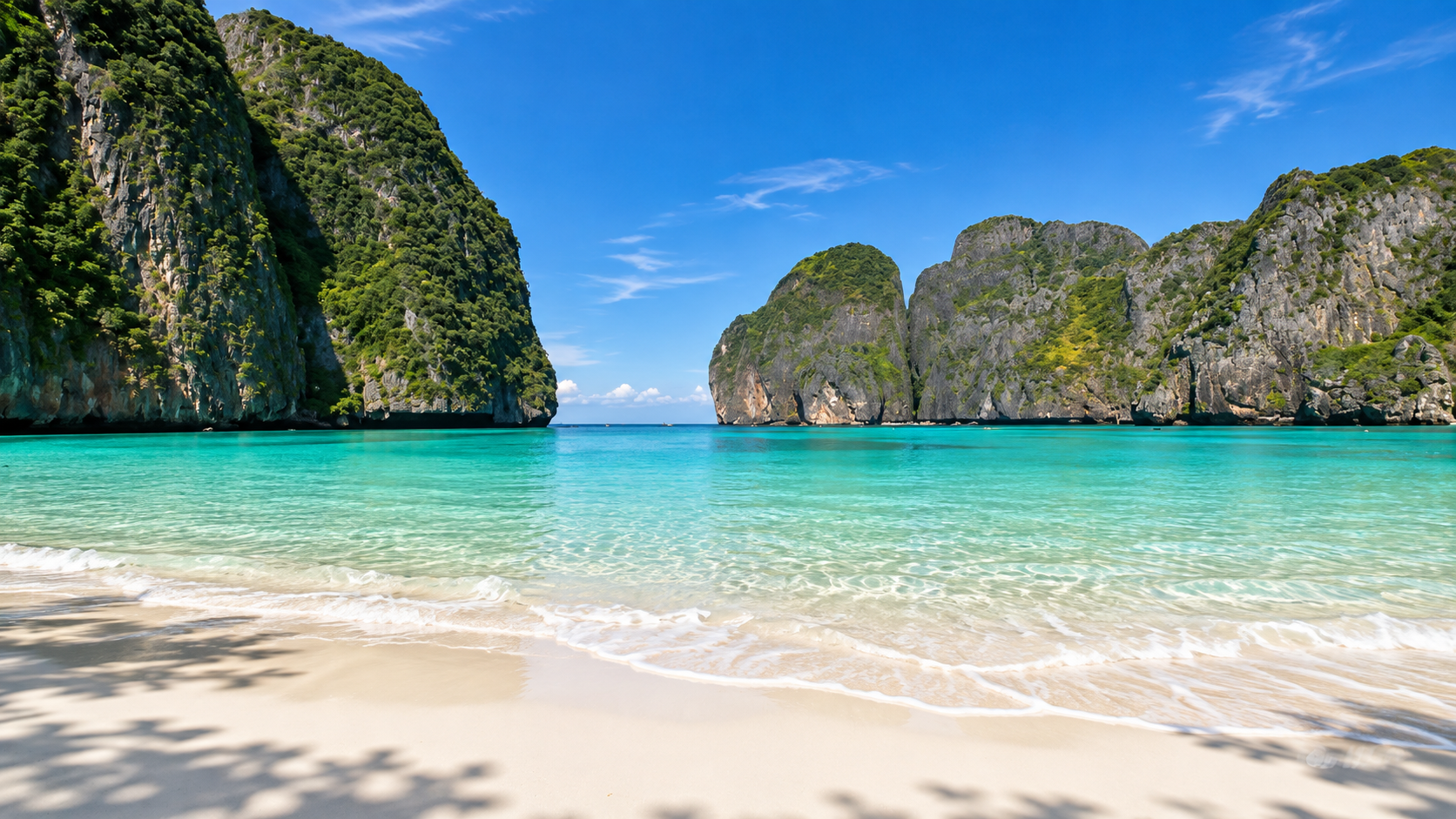
And, most famously: Maya Bay.
Maya Bay
The World’s Most Recognizable Tropical Bay
Maya Bay became internationally famous after appearing in the film The Beach. The movie transformed the destination into a global tourism phenomenon.
Visitor numbers eventually placed enormous pressure on coral reefs, beach vegetation, coastal water quality, sand systems, marine wildlife and waste-management infrastructure.
Thailand responded with one of the country’s most prominent marine conservation interventions: the temporary closure of Maya Bay for ecological recovery. The closure lasted for several years and became a landmark example of tourism-management policy in Thailand.
The Maya Bay Recovery
During the closure period, authorities focused on restoring the ecological condition of the bay: restricting direct beach access, changing boat access, establishing controlled visitor entry, improving walkways, installing environmental infrastructure, managing carrying capacity and supporting marine ecosystem recovery.
When the bay reopened, visitors were no longer permitted to simply return to the old tourism model. The objective was different: tourism within ecological limits.
DNP continues to treat Maya Bay as a high-pressure destination requiring strict visitor management. Boats do not simply arrive directly at the famous beach in the old manner. Visitors are routed through designated infrastructure and controlled access arrangements designed to reduce environmental pressure.
Carrying Capacity
DNP has implemented carrying-capacity controls in Maya Bay. A previously announced operating model limited visitor numbers to approximately 4,125 visitors per day, divided into time-based admission periods, with each hourly round capped at 375 visitors.
Such arrangements can be revised as management conditions change. ThailandLover treats current capacity as an operational figure rather than permanent park law — which is why evergreen editorial should stay separate from current visitor information.
The beach itself is relatively small. That is part of the problem. The scenery is large in the imagination, but the physical visitor space is limited. A relatively small beach cannot indefinitely absorb thousands of visitors, boats, waste streams and associated infrastructure without ecological consequences.
Pileh Lagoon
A Limestone Amphitheatre Filled with Water
On the other side of Phi Phi Leh lies Pileh Lagoon, one of the park’s most spectacular marine landscapes. Tall limestone cliffs surround a sheltered body of clear water. The lagoon appears almost enclosed.
From above, it resembles a natural amphitheatre. From the water, the walls rise dramatically on all sides. This is one of the strongest examples in the park of the relationship between limestone + sea + erosion.
Loh Samah Bay
Loh Samah Bay lies on the southern side of Phi Phi Leh. It functions as another access point within the island landscape and has been incorporated into visitor-management arrangements associated with Maya Bay. A designated floating-pier and elevated-access system has been used to move visitors toward Maya Bay without concentrating boats directly on the main beach frontage.
Viking Cave
A Cave With a Human Story
Viking Cave contains ancient-looking paintings and has long been associated with the harvesting of swiftlet nests, an important local economic activity. The cave should not be treated simply as a photographic attraction. Its story intersects marine ecology, local livelihoods, cave environments and traditional resource use.
Access conditions can be restricted or managed according to current conservation policy.
The Phi Phi Sea
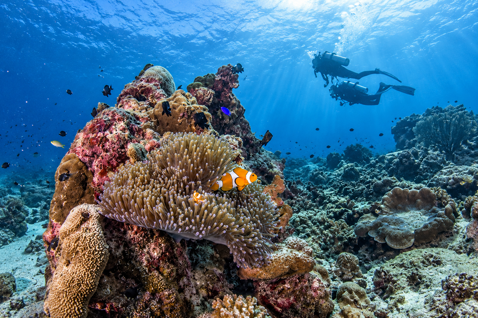
The waters around Phi Phi are famous for their clarity and colour. But the sea should not be viewed simply as a blue background. Underneath it are coral communities, reef fish, seagrass in suitable shallow habitats, sandy seabed, rocky substrates, planktonic life and marine food webs.
The famous blue-green water is influenced by depth, light, seafloor composition, sediment, reef or sand substrate, weather and sun angle. Shallow water over pale sand can appear turquoise. Deeper water appears darker blue. The colour is a product of physical environment and light — not simply “clear tropical water.”
Coral Reefs
Coral communities are particularly associated with popular snorkeling and diving areas around the islands. Reef environments can be damaged by physical contact, boat anchoring, sediment, pollution, excessive tourism pressure, rising sea temperatures and coral bleaching.
This makes visitor behaviour an ecological issue. A single person standing on living coral is not harmless.
Snorkeling & Diving
The Phi Phi–Krabi area is famous for snorkeling because many marine habitats occur in relatively shallow water — around Phi Phi Leh, Poda, Tup and smaller offshore islands. Visibility changes with weather, tide, wind, water movement, sediment and season.
The wider Phi Phi region is also an established diving destination: reef fish, coral structures, rock walls, caves, pelagic species and other marine life. Diving reveals the vertical character of the islands from underwater. The limestone cliffs continue below the surface.
The Nearshore Islands
Ko Poda
The Classic Island
Ko Poda is one of the most recognizable islands near the Krabi mainland: white sand, clear shallow water, limestone, tropical vegetation and an offshore rock formation. It has become one of the classic day-trip destinations from Ao Nang. Because of its popularity, it also experiences significant visitor pressure.
Ko Tup & Ko Mor
Sandbars & Shallow Water
Ko Tup is particularly famous for the sandbar connection that can appear between islands under suitable tidal conditions. The precise visibility and shape of the sandbar vary with tide, water level, weather and sediment movement. Photographs often show a perfect strip of sand. Nature rarely guarantees the same composition twice.
Ko Mor sits close to Ko Tup and contributes to the iconic island-hopping landscape. The relationship between the two is particularly interesting at low tide, when shallow sand and reef environments become more visible.
Ko Mai Phai
Bamboo Island
Ko Mai Phai is commonly known as Bamboo Island: white sand, shallow turquoise water, coral reef environments and open sea views. The name can lead visitors to expect dense bamboo. The more important characteristic is its beach-and-reef landscape.
Ko Yawasam
Ko Yawasam is a smaller island associated with shallow reef and snorkeling environments. Its importance lies less in major infrastructure and more in its position within the wider marine ecosystem.
The park’s identity is not limited to the internationally famous Maya Bay. The mainland and islands contain many beaches and coves that are less globally recognizable. A destination becomes more interesting when visitors understand the whole landscape, rather than simply visiting one famous photograph.
Mangroves, Wildlife & Inaccessible Places
The mainland component of the park contains coastal ecosystems that transition between land and sea. Mangroves and tidal environments contribute to fish nursery habitat, shoreline protection, sediment retention, bird habitat and nutrient cycling. They may appear less spectacular than a limestone cliff. Ecologically, they are essential.
The waters of the park support reef fish, sea turtles, dolphins, rays, marine invertebrates, corals and coastal birds. Sightings of any individual species should never be presented as guaranteed. Visitors should never touch a turtle, chase one or interfere with nesting activity. Boat operators should avoid chasing, surrounding, cutting across animal paths or sudden acceleration.
Coastal forests, cliffs, islands and shoreline habitats provide space for egrets, herons, terns, kingfishers, swifts and forest species. Sea cliffs and inaccessible islands are particularly valuable because some areas remain relatively difficult for humans to reach.
Sometimes the absence of tourism is the conservation mechanism.
A cliff that tourists cannot easily climb may function as habitat. An island with no hotel may provide refuge. A cave closed to visitors may protect wildlife. A bay with restricted boat access may allow ecological recovery.
Why the Park Is Under Pressure
The park is exceptionally popular. That creates direct pressure from boats, visitors, waste, anchoring, shoreline infrastructure, coral contact, noise, freshwater demand, sewage, coastal construction and wildlife disturbance.
The DNP reported more than 148 million baht in park-related revenue during January–February 2026, illustrating the scale of tourism activity in this single national park. Economic success and ecological pressure therefore exist simultaneously.
Modern management increasingly relies on a simple principle: high visitation does not automatically justify unlimited access. Tools include visitor caps, timed entry, designated boat routes, mooring systems, restricted areas, walkways, ranger monitoring, seasonal measures, carrying-capacity assessments and environmental rehabilitation.
Maya Bay is the most visible example. But the same philosophy matters across the wider park.
Why Maya Bay Changed Thailand
Before the closure, the dominant tourism model was simple: boat → beach → photograph → leave. After restoration, the model became more structured: boat → controlled landing → walkway → beach → controlled exit.
The question is no longer simply how many tourists can we bring. It becomes: how many tourists can this ecosystem absorb?
When to Visit
The Andaman coast has a pronounced seasonal pattern. For island travel, the most favourable conditions are generally associated with the drier part of the year, when sea conditions are often calmer. Exact conditions vary from year to year.
Weather can affect boat departures, snorkeling visibility, cave access, swimming, beach conditions and marine safety. The park may also impose temporary restrictions when environmental or weather conditions require them.
- Morning
- Best for cooler temperatures, softer light, boat departures, photography and longer excursions.
- Midday
- Strong sunlight can produce vivid water colours but also harsher contrast.
- Late afternoon
- The mainland coast can become especially attractive for sunset, coastal walks and lower-intensity exploration.
Exact marine conditions should always take priority over photographic plans.
How Long Should You Stay?
- One day
- Suitable for a classic island-hopping excursion.
- Two days
- Much better. Combine mainland and islands.
- Three days or more
- Best for a deeper ThailandLover experience: Noppharat Thara, Ao Nang, Phi Phi, Maya Bay, Pileh Lagoon, Poda, Tup, local communities, diving and slower coastal time.
The more time you allow, the less pressure there is to turn the park into a checklist.
A ThailandLover Day
- 07:00
- Start from the Krabi / Ao Nang area.
- 08:00
- Travel toward the offshore islands.
- Morning
- Explore selected Phi Phi destinations according to current regulations and sea conditions.
- Midday
- Move through the marine landscape rather than staying concentrated at one site for too long.
- Afternoon
- Return toward the mainland.
- Late afternoon
- Explore Noppharat Thara or the quieter side of the coast.
A Better Two-Day Experience
Day 1 — The Mainland: Noppharat Thara Beach → Ao Nang → coastal landscape → sunset.
Day 2 — The Islands: Phi Phi Don → Phi Phi Leh → Maya Bay → Pileh Lagoon → Loh Samah → selected snorkeling area.
The route should follow current park restrictions rather than an old fixed itinerary.
Photography Guide
Hat Noppharat Thara–Mu Ko Phi Phi is one of Thailand’s strongest destinations for aerial and environmental landscape photography.
- Maya Bay
- Shoot for scale. The beach becomes more impressive when the limestone walls are included.
- Pileh Lagoon
- Use the vertical cliffs to frame the water.
- Phi Phi Don viewpoint
- The double-bay geometry is best understood from above.
- Poda
- Use the offshore limestone formation as a natural anchor.
- Tup & Mor
- Look for tidal changes and sandbar geometry.
- Noppharat Thara
- Use the mainland beach to show the relationship between Krabi and the offshore islands.
What Makes This Park Different?
Thailand has many marine national parks. Hat Noppharat Thara–Mu Ko Phi Phi has an unusually powerful combination:
- Mainland coast
- Noppharat Thara and the Krabi shore still matter.
- Limestone islands
- Karst walls rise directly from the Andaman Sea.
- Famous marine landscapes
- Maya Bay and Pileh Lagoon are globally recognized.
- Coral areas
- Shallow reefs sit beside some of the busiest boat routes in Thailand.
- Local communities
- Phi Phi Don is a lived-in island, not a wilderness postcard.
- Intensive conservation management
- Carrying capacity and controlled access are now part of the destination.
The name “Phi Phi” dominates global awareness. But the national park is larger than Phi Phi Don and Phi Phi Leh. The mainland coast matters. Noppharat Thara matters. Poda matters. Tup matters. The coastal forest matters. The reefs matter. The marine spaces between the islands matter.
The ecological system exists between the photographs.
Frequently Asked Questions
- Where is Hat Noppharat Thara–Mu Ko Phi Phi National Park?
- It is in Krabi Province, southern Thailand, along the Andaman coast.
- Is Hat Noppharat Thara–Mu Ko Phi Phi an official national park?
- Yes. It is an established and actively managed national park, designated in 1983.
- What is Hat Noppharat Thara–Mu Ko Phi Phi famous for?
- Maya Bay, Phi Phi Leh, Phi Phi Don, limestone islands, beaches, coral reefs and marine landscapes.
- Where is Maya Bay?
- On Ko Phi Phi Leh.
- Is Maya Bay always open?
- No. Access can be subject to park management, conservation measures, weather and operational restrictions.
- Can visitors arrive directly at Maya Bay beach by boat?
- Visitor-management arrangements have been designed to reduce direct boat impacts on the beach, and access procedures can change according to park policy.
- What is Pileh Lagoon?
- A spectacular enclosed limestone lagoon on Phi Phi Leh.
- What is Viking Cave?
- A marine cave on Phi Phi Leh associated with swiftlet-nest harvesting and historical cave paintings.
- Is Phi Phi Don uninhabited?
- No. Phi Phi Don is inhabited and contains substantial tourism and local-community infrastructure.
- Is Phi Phi Leh inhabited?
- It is generally regarded as uninhabited and is primarily managed as a protected natural destination.
- Why was Maya Bay closed?
- To allow the ecosystem, particularly the beach and shallow-water marine environment, to recover from intense tourism pressure.
- How many visitors can Maya Bay receive?
- A previously announced management model capped attendance at approximately 4,125 visitors per day, with timed sessions of up to 375 people per hour. Operational limits may be revised.
Related Destinations
- Ao Phang Nga National Park
- Another Andaman limestone seascape — karst islands and sheltered water north of Krabi.
- Hat Chao Mai National Park
- Trang’s Andaman islands, Emerald Cave and seagrass meadows further down the coast.
- Mu Ko Lanta National Park
- A quieter island-and-reef park south of Krabi in the Andaman Sea.
- Nature & Parks
- More protected landscapes across ThailandLover’s national-park collection.
Location
Find Hat Noppharat Thara–Mu Ko Phi Phi
Ao Nang, Krabi