

National Park · Surat Thani
Khao Sok National Park
อุทยานแห่งชาติเขาสก
Where the Rainforest Meets the Emerald Wilderness
Surat Thani · Southern Thailand
A ThailandLover guide to one of Southern Thailand’s most extraordinary protected landscapes — ancient rainforest, limestone karst, underground rivers and the emerald waters of Cheow Lan Reservoir.
Ancient Rainforest, Emerald Water
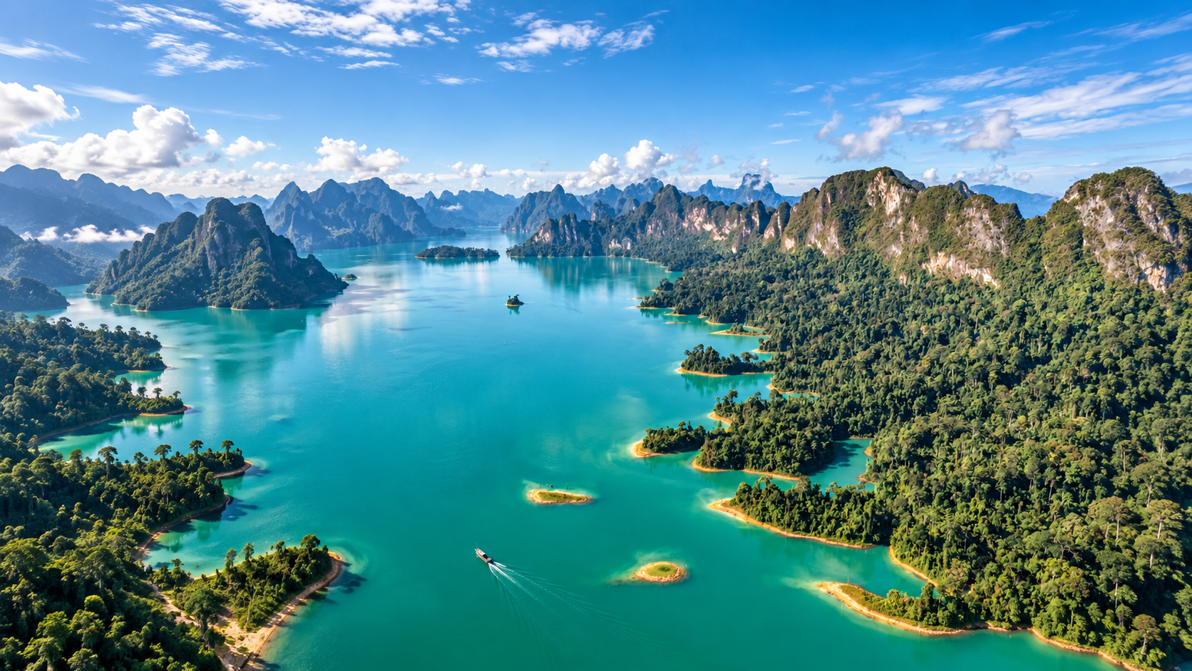
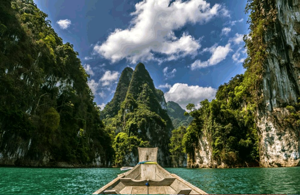
Khao Sok is often introduced through one image: a longtail boat moving between towering limestone cliffs on emerald-green water. That image is only the beginning.
Beyond Cheow Lan Lake lies a much larger landscape of rainforest, mountains, caves, rivers, waterfalls and wildlife. The park is part of the Khlong Saeng–Khao Sok Forest Complex, one of the major remaining forest systems of the Thai-Malay Peninsula.
It is also a place of contrasts. A rainforest ecosystem with a very long ecological history. A national park created in 1980. A massive reservoir created only a few years later. A landscape where valleys became water and former hills became islands. And a forest that still supports Asian elephants, Malayan tapirs, serow, gibbons, hornbills, rare plants and one of Thailand’s most remarkable flowers — Rafflesia kerrii.
Rainforest on one side. Emerald wilderness on the other. One park — two worlds.
At a Glance
- Official Name
- Khao Sok National Park
- Thai Name
- อุทยานแห่งชาติเขาสก
- Province
- Surat Thani, Southern Thailand
- Districts
- Phanom and Ban Ta Khun
- National Park
- 22nd national park of Thailand
- Gazetted
- 22 December 1980
- Area
- 461,712.5 rai / 738.74 km²
- International Status
- ASEAN Heritage Park — 50th AHP, designated 2021
- Main Ecosystem
- Moist evergreen rainforest
- Signature Landscape
- Limestone karst + Cheow Lan Reservoir
- Landmark
- Khao Sam Kler / The Three Brothers
- Signature Flower
- Rafflesia kerrii
- Headquarters
- Khlong Sok, Phanom, Surat Thani 84250
The 738.74 km² figure is the legally described national-park area used by TAT and Thailand’s biodiversity information. The ASEAN Heritage Park database currently lists 660.65 km² for the AHP component; that figure should not be substituted for the full park when describing Khao Sok National Park itself.
Two Experiences in One Park
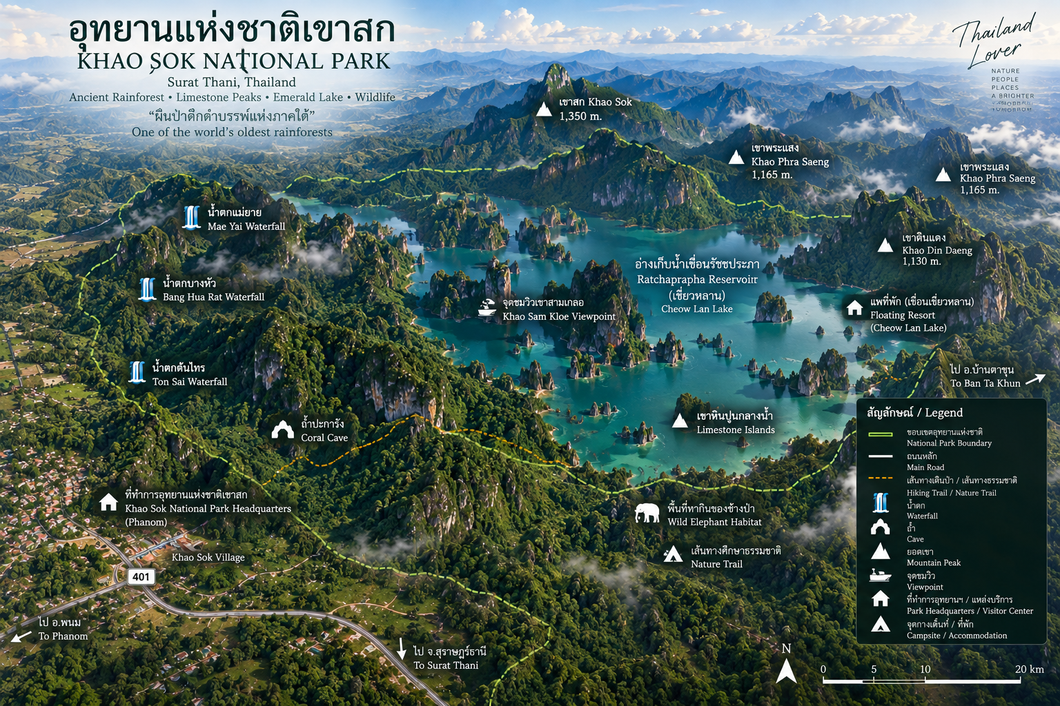
Khao Sok sits in the middle of the southern peninsula, between the Andaman Sea and the Gulf of Thailand. Monsoon systems from both sides contribute to exceptionally high rainfall. The park extends across forested mountains around Khlong Sok, Phanom and Ban Ta Khun.
- West — the rainforest
- Khao Sok Village, park headquarters, the Sok River, jungle trails, waterfalls, forest viewpoints, wildlife and Rafflesia viewing areas. This is the walking side of Khao Sok.
- East — the emerald reservoir
- Ratchaprapha Dam, Cheow Lan Reservoir, limestone karst islands, Khao Sam Kler, floating raft houses, caves and longtail-boat journeys. This is the water-and-karst side.
These two visitor areas belong to the same national park, but they are not connected by a visitor road through the forest. Travelling between them means returning to the main road network and driving around the park.
A Forest Larger Than the Postcard
Khao Sok covers approximately 738.74 km² — substantially larger than many of Thailand’s better-known national parks. The important number is not only its size. The park sits inside the Khlong Saeng–Khao Sok Forest Complex, linking Khao Sok with surrounding protected forests and wildlife sanctuaries across Southern Thailand.
For elephants, tapirs and predators, connectivity is survival. Khao Sok does not exist as an isolated green island. The wider system includes protected forest around Khlong Saeng, Khlong Yan, Khlong Naka, Khlong Phanom and other connected landscapes.
A Rainforest with Deep Time
Khao Sok is frequently described as having one of the world’s oldest rainforests. The scientifically safer interpretation is that the region represents an ancient tropical forest landscape with a very long ecological history — not that every individual tree has survived continuously for a fixed number of millions of years.
The limestone itself records an even older history. Much of it originated in ancient marine environments. Rainwater, enriched with weak acids from soil and vegetation, dissolved the rock over immense periods of time. The result is what visitors see today: vertical cliffs, tower karst, caves, sinkholes, narrow valleys and isolated peaks.
Forest → cliff → cave → underground stream → waterfall → lake.
Cheow Lan Is Not a Natural Lake
What visitors commonly call Cheow Lan Lake is technically a reservoir. It was created by Ratchaprapha Dam, originally known as Cheow Lan Dam. Construction began on 9 February 1982 and was completed in September 1987. The dam and hydropower plant were inaugurated on 30 September 1987. King Bhumibol Adulyadej gave the dam the name Rajjaprabha — “Light of the Kingdom.”
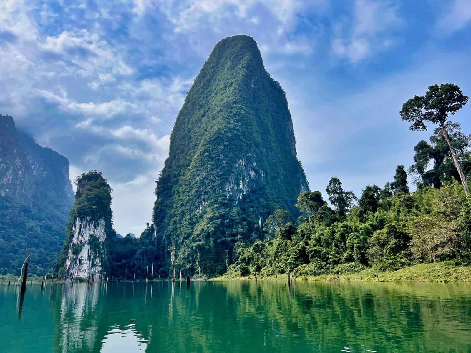
Before the water, the valleys held rivers, forests, farms, villages and limestone hills. When the dam closed the river system, former lowlands became the lake, former hills became islands, and limestone formations that had stood within continuous forest became isolated above the water.
The mountains did not rise from the lake. The lake rose around the mountains.
- Dam height
- Approximately 95 metres
- Dam length
- Approximately 700–761 metres, depending on the measurement convention
- Reservoir
- About 185 km²
- Hydropower
- About 240 MW installed capacity
The project serves electricity generation, water management, irrigation, flood management and fisheries. The reservoir later became one of Southern Thailand’s most important nature-tourism destinations. Before the valley was flooded, Ban Chiew Lan and other settlements existed here. Approximately 385 families were relocated. That history should not disappear beneath the postcard of emerald water.
Khao Sam Kler — The Three Brothers
No landscape in Khao Sok is more recognisable than Khao Sam Kler — three dramatic limestone pinnacles emerging from the reservoir. From a longtail boat the scene is almost surreal: emerald water, vertical limestone walls, mist drifting through the forest, and three narrow peaks rising from the lake.
This is the image that has earned the region comparisons with Guilin in China. The comparison is useful for the limestone-and-water part. It does not explain rainforest, tapir, elephant, Rafflesia, underground rivers or endemic plants. ThailandLover’s deeper description is a rainforest karst wilderness — not simply “Thailand’s Guilin.”
Moist Evergreen Forest
According to the ASEAN Centre for Biodiversity, moist evergreen forest accounts for approximately 65% of the AHP area, with freshwater reservoir and limestone karst forming other major habitats. The forest is a multi-layer ecosystem: forest floor, understory, mid-canopy, upper canopy and emergent trees. Each layer provides different food and shelter.
Khao Sok is also a major watershed. Rain falling on the mountains is captured by the forest and released through streams, springs, tributaries, waterfalls and rivers. The park forms part of the upper catchment of the Tapi River basin. Conservation here is water regulation, soil protection, biodiversity, carbon storage and habitat connectivity — not only scenery.
The Sok River / Khlong Sok defines the western visitor zone. Depending on conditions, visitors can kayak, canoe, tube, walk riverside trails and watch wildlife. The river is a direct visual connection between the mountain forest and the communities around the park.
Waterfall Country
Khao Sok is not only a lake destination. The western trails hold a network of forest waterfalls whose appearance changes with rainfall.
- Ton Kloi Waterfall
- น้ำตกโตนกลอย. A major rainforest waterfall reached by the main jungle trail.
- Than Sawan Waterfall
- A waterfall along the park’s rainforest trekking network.
- Bang Hua Rat Waterfall
- One of the more accessible waterfall destinations on the western trails.
- Mae Yai Waterfall
- น้ำตกแม่ยาย. A prominent waterfall near the road network and one of the easier waterfall stops.
- Ton Sai Waterfall
- A smaller forest waterfall associated with the rainforest trail system.
Khao Sok is not one hike. It is a network of forest experiences. Trails lead through lowland rainforest, bamboo, limestone terrain, stream valleys, waterfalls, caves and wildlife habitat. Conditions vary with rainfall; some routes become significantly more difficult when wet.
Pakarang, Diamond Cave and Nam Talu
The same geology that built the cliffs also built the caves. Some are dry. Some contain underground streams. Some are reached by boat. Others require substantial trekking.
- Pakarang Cave / Coral Cave
- ถ้ำปะการัง. Named for formations that resemble coral: stalactites, stalagmites, flowstone and mineral surfaces. Reached by a combination of boat travel and walking or raft access in the Cheow Lan landscape. TAT notes fossils in surrounding formations, with some reported material dating hundreds of millions of years.
- Diamond Cave / Tham Pra Kay Petch
- ถ้ำพระไกรเพชร. A comparatively accessible dry limestone cave. Compared with Nam Talu, it is the more straightforward cave experience.
- Nam Talu Cave
- ถ้ำน้ำทะลุ — “through-water cave.” An underground stream, wading, swimming, slippery rocks and darkness. This is not a casual sightseeing cave. It is particularly dangerous during heavy rainfall because water levels can rise rapidly. Enter only when officially open and under authorised guidance. The cave has a documented history of fatal accidents during sudden flooding.
Rafflesia, Khaosokia and Rare Plants
Rafflesia kerrii produces some of the world’s largest individual flowers — about 70–80 cm or more across, depending on the specimen. It is parasitic, living inside host vines of the genus Tetrastigma until it produces its enormous bloom. The plant develops for months; the visible flower may remain open for only several days. It has no conventional leaves, stems or roots. The carrion-like odour attracts flies. Khao Sok is an important habitat, and Rafflesia is also the provincial flower of Surat Thani.
A commonly cited flowering period is approximately January–March, but flowering is unpredictable. Do not travel assuming a bloom. When a flower is found, follow park guidance and avoid stepping on surrounding vegetation.
Khaosokia caricoides is even more geographically restricted. Discovered in Khao Sok in 2001 and described as a new genus and species in 2005, this sedge grows in crevices on limestone cliffs around the reservoir, at about 60–80 metres above sea level. The reservoir ironically made previously difficult cliffs easier to reach by boat, facilitating its discovery.
The limestone and rainforest also support orchids, palms, ferns, epiphytes, rattan, Maxburretia species, Impatiens sirindhorniae, Paphiopedilum exul and Paphiopedilum godefroyae. The ASEAN Centre for Biodiversity identifies multiple endemic and conservation-important plants here.
Wildlife & Birdlife
ASEAN Heritage Park information records approximately 95 mammal species, 296 bird species, 96 reptile species, 46 amphibian species and 118 fish species. Inventories change as research improves; the numbers show ecological complexity, not a safari checklist.
- Malayan tapir
- The black-and-white ghost of the rainforest. Nocturnal, solitary, forest-dependent and Endangered. A tapir sighting is never part of a standard itinerary. Its presence matters because the forest still holds habitat for large, sensitive mammals.
- Asian elephant
- Wild elephants occur in the wider Khao Sok forest. This is not a safari park. Never approach, block, feed, follow or attempt to touch wild elephants. Observation at a safe distance is the only correct experience.
- Serow
- A goat-antelope relative adapted to steep rocky terrain. The limestone cliffs provide exactly this habitat. Classified as Vulnerable.
- Primates and birds
- Gibbons, macaques and langurs are often heard before they are seen. A distant gibbon call is one of the classic sounds of Khao Sok. Birds include hornbills, pittas, kingfishers, barbets, broadbills and raptors. Hornbills are important seed dispersers. Look upward. Listen. Wait.
Reported mammals also include leopard, sun bear, marbled cat, Asiatic wild dog, civets, porcupines, wild boar, deer, mouse deer and bats. Several are extremely difficult to observe. Their presence indicates a functioning food web, not isolated populations of famous animals.
ASEAN Heritage Park, 2021
Khao Sok was designated the 50th ASEAN Heritage Park in 2021 — Thailand’s seventh at the time. The recognition covers biodiversity, rainforest ecosystems, limestone karst, rare species, watershed importance and ecological connectivity. It places Khao Sok in the wider network of Southeast Asia’s most important protected landscapes.
How the Park Survived — and Changed
Local historical tradition associates the name Khao Sok with a severe epidemic in the 1940s and a settlement remembered as Ban Sop, “Village of the Dead.” The mountain name Khao Sop is sometimes given as an explanation for the modern name. The exact linguistic origin is not conclusively established. ThailandLover presents this as local historical tradition, not an unquestionable etymological fact.
Highway 401 later connected the Surat Thani side of the peninsula with Takua Pa and Phang Nga. Access brought settlement, agriculture, mining and logging — and greater pressure on the rainforest. During the 1970s, dense forest and cave systems became a stronghold for communist insurgents and politically active students. Conflict made large-scale logging, mining and hunting more difficult in parts of the forest. That chapter should not be romanticised. Historically, it contributed indirectly to the survival of large areas of forest until formal conservation arrived.
On 22 December 1980, Khao Sok became Thailand’s 22nd national park. The legal history was later updated in 1993. Only two years after designation, dam construction began. By 1987, valleys had become a reservoir. The Khao Sok visitors see today is ancient forest plus modern infrastructure: geological time, ecological time, human history and twentieth-century water development in one landscape.
Floating Raft Houses and Longtail Boats
One of Khao Sok’s signature experiences is sleeping on Cheow Lan Reservoir in a floating raft house — from simple bungalows to more comfortable lake resorts. At night there is little road noise. Mountains become silhouettes. The forest surrounds the accommodation. Early-morning mist can settle between limestone peaks.
The most beautiful time on the lake is often not midday. It is early morning, when mist forms above the water, peaks emerge from haze, bird calls move through the forest and the surface becomes almost mirror-like. Longtail boats are the principal way to explore: Khao Sam Kler, raft houses, caves, waterfalls, remote forest and viewpoints. The lake is large enough that travel time varies. There is no single “Cheow Lan Lake tour.”
When to Go
Khao Sok receives substantial rainfall and remains humid for much of the year.
- December–April
- Generally the drier period. TAT currently identifies it as favourable for lake sightseeing, boat trips, trekking, clearer skies and outdoor activities.
- May–November
- Generally wetter. The rainforest is lusher, waterfalls stronger and clouds more dramatic — but trails are slippery, river levels change, caves may close and flash-flood risk rises. Check weather before travel.
Nam Talu is especially sensitive to rainfall. Access is condition-dependent, not guaranteed. Upstream weather can change the cave even when the entrance looks manageable.
How to Experience Khao Sok
- Rainforest Khao Sok
- Trekking, waterfalls, wildlife, caves, river activities and Rafflesia. Base: Khao Sok Village / park headquarters.
- Cheow Lan Khao Sok
- Longtail boats, limestone scenery, floating accommodation, sunrise, caves and lake photography. Base: Ratchaprapha Dam / Cheow Lan Reservoir.
- The complete Khao Sok
- Rainforest + waterfalls + Cheow Lan + limestone + a floating stay. This is the strongest way to read the landscape.
One day is possible but highly compressed — choose rainforest or lake. Two days / one night is a good introduction. Three days / two nights is recommended: rainforest, waterfall, longtail boat, floating accommodation and sunrise. Four to five days suits serious trekking, caves, wildlife watching and photography.
How to Get to Khao Sok National Park
Headquarters: Moo 6, Khlong Sok Subdistrict, Phanom District, Surat Thani 84250, reached from Highway 401. Khao Sok sits between several major southern destinations, so travellers commonly combine it with Surat Thani, Phuket, Khao Lak, Phang Nga, Krabi or Koh Samui.
- From the Andaman coast
- Phuket or Khao Lak inland to Khao Sok — or Krabi to Khao Sok. The park functions as a nature bridge between Andaman and Gulf circuits.
- From the Gulf
- Surat Thani, then west toward Highway 401 and the Khlong Sok access road — or continue from Khao Sok toward Koh Samui / Koh Phangan via Surat Thani.
- Cheow Lan / Ratchaprapha
- A separate eastern approach. Do not assume the village trails and the dam pier are a short forest transfer. Allow road time around the park.
Current Visitor Information
- Address
- Khlong Sok, Phanom, Surat Thani 84250
- Park hours
- 08:00–17:30 (published TAT hours)
- Visitor Service Centre
- +66 77 395 139
- Park Office
- +66 77 395 155
- Entrance fee
- Thai adult 40 THB / child 20 THB; foreign adult 200 THB / child 100 THB
Individual attractions can have separate seasonal closures. The park’s current announcement always takes precedence over general opening hours.
Responsible Travel & Safety
Khao Sok is an ecosystem, not a theme park.
- Stay on designated trails and use authorised guides where required
- Follow cave restrictions — if Nam Talu is closed, do not enter
- Keep noise low; never use loud music in the forest
- Carry rubbish out and use refillable bottles
- Never feed, touch, chase or block wildlife — especially elephants
- Do not collect plants, flowers, rocks or fossils, or damage limestone
- Do not swim in dangerous currents
- Do not fly drones without permission
- Follow park instructions during heavy rain
If an elephant appears: stop, stay quiet, keep distance, do not block its route, and follow ranger instructions. The objective is not the closest photograph. The objective is to let the animal continue living naturally.
Must-Experience
- 01 — Cheow Lan Reservoir
- Emerald water among limestone islands — a reservoir, not a natural lake, and still one of Thailand’s great landscapes.
- 02 — Khao Sam Kler
- The Three Brothers, best read from a moving longtail boat.
- 03 — Rainforest trails
- The walking side of Khao Sok: canopy, streams, wildlife calls and humidity.
- 04 — Ton Kloi and Mae Yai
- Forest waterfalls that change character with the rain.
- 05 — Nam Talu, if open
- An underground river that demands respect — never when the park has closed it.
- 06 — Rafflesia, if in bloom
- A giant parasitic flower that may open for only a few days.
- 07 — A floating raft house
- Sleep on the water so the lake becomes your environment, not a viewpoint.
- 08 — Sunrise mist
- Limestone peaks emerging from haze before the heat of the day.
Essential Khao Sok
- Name
- Khao Sok National Park
- Thai
- อุทยานแห่งชาติเขาสก
- Province
- Surat Thani
- Districts
- Phanom and Ban Ta Khun
- Area
- 461,712.5 rai / 738.74 km²
- Established
- 22 December 1980 · 22nd national park
- Landscape
- Moist evergreen forest · limestone karst · reservoir · caves · waterfalls
- Signature Experiences
- Cheow Lan · Khao Sam Kler · rainforest trekking · Rafflesia · floating stay
- Headquarters
- Khlong Sok, Phanom, Surat Thani 84250
- Access
- Highway 401 · Khao Sok Village · Ratchaprapha Dam (separate approach)
Frequently Asked Questions
- What is Khao Sok National Park?
- Thailand’s 22nd national park, gazetted on 22 December 1980. About 461,712.5 rai / 738.74 km² of rainforest, limestone karst, caves, waterfalls and Cheow Lan Reservoir in Phanom and Ban Ta Khun, Surat Thani. Designated the 50th ASEAN Heritage Park in 2021.
- Is Cheow Lan Lake a natural lake?
- No. It is a reservoir created by Ratchaprapha Dam, completed in 1987. Former valleys became waterways and former hills became islands.
- Are the rainforest and Cheow Lan in the same park?
- Yes — but they are not linked by a visitor road through the forest. Travelling between village trails and the dam pier means driving around the park.
- How do I get to Khao Sok National Park?
- Headquarters: Moo 6, Khlong Sok, Phanom, Surat Thani 84250, from Highway 401. Combine with Phuket, Khao Lak, Krabi, Surat Thani or Koh Samui. Cheow Lan is a separate eastern approach.
- Can I see Rafflesia kerrii in Khao Sok?
- Sometimes, never as a guarantee. Flowering is often cited for January–March, but individual plants are unpredictable and the bloom may last only a few days.
- Is Nam Talu Cave safe?
- Only when officially open and under authorised guidance. Water can rise rapidly. If the park closes the cave, do not enter.
- When is the best time to visit?
- December–April is generally drier and better for boats and trekking. May–November is lusher, wetter and more restricted for caves. Confirm with the park.
- How long should I stay in Khao Sok?
- One day forces a choice. Two days is a good introduction. Three days and two nights is recommended. Four to five days suits slower travel.
- What are the entrance fees?
- Published rates: Thai adults 40 THB, children 20 THB; foreign adults 200 THB, children 100 THB. Verify before travel.
- How do I contact the park?
- Visitor Service Centre +66 77 395 139 · Park Office +66 77 395 155 · Khlong Sok, Phanom, Surat Thani 84250.
Related Destinations
- Kaeng Krung National Park
- A quieter Surat Thani forest-and-river wilderness in the same southern mountain system.
- Khlong Phanom National Park
- Another forested mountain landscape in Surat Thani, part of the wider connected forest.
- Khao Lak–Lam Ru National Park
- The Andaman-side mountain forest, often combined with Khao Sok on the Highway 401 crossing.
- Tai Rom Yen National Park
- Highland forest and waterfalls on another face of the peninsula’s mountain wilderness.
- Nature & Parks
- More protected landscapes across ThailandLover’s national-park collection.
Location
Find Khao Sok National Park
Moo 6, Khlong Sok Subdistrict, Phanom District, Surat Thani 84250