



National Park · Phang Nga
Khao Lak–Lam Ru National Park
อุทยานแห่งชาติเขาหลัก–ลำรู่
Where Rainforest Mountains Meet the Andaman Sea
Phang Nga · Southern Thailand · Andaman Coast
A ThailandLover guide to a complete mountain-to-ocean landscape — forest, waterfalls, coastal rocks and quiet Andaman beaches — hidden behind one of Thailand’s most beloved beach destinations.
A Landscape That Feels Complete
Khao Lak–Lam Ru National Park is one of Phang Nga’s most distinctive protected landscapes — a place where steep tropical mountains, ancient rainforest, waterfalls, streams, rocky headlands and quiet Andaman beaches exist within one continuous environment. This ThailandLover guide covers the legally protected park, not the entire Khao Lak resort strip.
Unlike destinations defined by a single spectacular landmark, this park is defined by the relationship between mountain and sea. Water begins in the forested highlands, travels through valleys and streams, and eventually reaches the Andaman coast. Along the way the landscape changes from humid evergreen forest to waterfalls, beach forest, rocky shoreline and sand.
The result is a national park that feels unusually complete: forest, mountain, freshwater and sea in one landscape — a standout in ThailandLover’s Nature & Parks collection.
Rain falls on the mountains → forest holds the water → streams descend → waterfalls form → rivers continue toward the Andaman Sea.
At a Glance
- Official Name
- Khao Lak–Lam Ru National Park
- Thai Name
- อุทยานแห่งชาติเขาหลัก–ลำรู่
- Province
- Phang Nga, Southern Thailand
- Region
- Andaman Coast
- National Park
- 66th national park of Thailand
- Gazetted
- 30 August 1991
- Area
- Approximately 78,125 rai / 125 km²
- Highest Elevation
- Approximately 1,077 metres
- Districts
- Takua Pa, Kapong, Thai Mueang and Mueang Phang Nga
- Main Ecosystems
- Moist evergreen forest, beach forest, mangrove, rocky coast, sandy beach and coastal waters
- Main Attractions
- Khao Lak Beach, Small Sandy Beach, Ton Chong Fa, Lam Ru, Lam Phrao and Hin Lat waterfalls
- Headquarters
- Khuekkhak, Takua Pa, Phang Nga
The Story of Khao Lak–Lam Ru
The park was not originally conceived simply as a coastal recreation area. The protected landscape developed from an effort to preserve the forests and watersheds of interior Phang Nga.
Before becoming a national park, the coastal section was known as Khao Lak Seashore Forest Park, while the inland forests around Lam Ru were recognised for their rich forest resources, waterfalls and importance as headwaters. During the 1980s, surveys found extensive intact forest, important watershed areas and several natural features suitable for conservation.
The name reflects two geographic features: Khao Lak, associated with the Andaman coast, and Lam Ru, associated with the inland mountain and waterfall system. The area was officially declared Thailand’s 66th national park on 30 August 1991.
This is not simply a beach park. Its purpose is a much larger ecological system — from the mountain watershed to the coast.
A Landscape from Mountain to Sea
The geography is one of the park’s greatest strengths. Mountains and ridges include Khao Lak, Khao Lam Ru, Khao Saeng Thong, Khao Mai Kaew and Khao Plai Bang To. The highest summit reaches approximately 1,077 metres.
Forested slopes collect rainfall, feed streams and contribute to the river systems of Phang Nga, including the Takua Pa and Phang Nga river systems. Smaller waterways associated with the park include Khlong Bang Niang, Khlong Bang La On, Khlong Kao, Khlong Lam Ru Duan, Khlong Lam Ru Yai, Khlong Thung Kha Khong and Khlong Kapong.
That hydrological connection is one of the fundamental reasons the forest matters. The mountains function as a natural water tower. Rainfall is captured by vegetation and soil, then moves downhill through streams, ravines, waterfalls and larger channels. The forest therefore supports water regulation, soil stability, aquatic ecosystems and downstream communities — far beyond scenery.

A National Park with Two Faces
One of the most interesting characteristics of Khao Lak–Lam Ru is that it has both a mountain interior and a coastal landscape.
- Inland
- Steep terrain, evergreen forest, streams and waterfalls. The forest is humid, dense and layered, with tall trees forming a canopy above palms, ferns, vines, orchids and other moisture-loving plants.
- Coastal
- Rocky headlands, rocky and sandy beaches, beach forest, coastal vegetation and nearshore coral communities. Headquarters sits in the coastal section of Khao Lak, so visitors can move from a park office and forest trail to the shoreline within minutes.
Even though the park is relatively close to the Andaman coast, its highest elevations rise to more than one kilometre above sea level. That vertical difference is one reason such varied habitats exist within a comparatively compact area:
coastal vegetation → beach forest → lowland forest → moist evergreen forest → mountain forest → watershed headwaters.
The Forests of Khao Lak–Lam Ru
The dominant ecosystem is moist evergreen forest — the ecological heart of the park. High rainfall, mountainous terrain and permanent or seasonal streams create a humid environment capable of supporting remarkable plant diversity.
Reported trees include yang, takian, payom, lumpor, bunnak, krabak, sator, riam, takhian hin, takhian thong, wild nutmeg-related species, Alstonia and other evergreen-forest trees. Large trees create a multilayered canopy; the forest floor supports ferns, palms, vines, herbs and mosses. Some areas contain remarkable large specimens, including large gymnosperm trees recorded within the park landscape.
Beach forest
Near the Andaman coast the vegetation changes dramatically. Beach forest must tolerate strong sunlight, salt spray, wind, sandy soils and periodic water stress. Plants associated with the coastal zone include sea almond, sea oak, sea hibiscus, beach pandanus, casuarina, Barringtonia, and coastal palms and shrubs.
The trees often have different forms from their inland counterparts — lower, wind-shaped or leaning away from prevailing coastal winds. This vegetation is not simply decorative. Beach forest is a natural transition between land and sea and helps stabilise coastal environments.
Mangrove ecosystems
Mangrove vegetation also occurs within the broader ecological system. Reported species include Rhizophora, Avicennia, Bruguiera, Xylocarpus, Aegiceras and associated salt-tolerant plants. Mangrove environments provide nursery habitat for aquatic organisms and help connect terrestrial and marine ecosystems.
This is more than a mountain forest with a beach attached. It is a connected ecological landscape.
Wildlife & Birding
The forest supports a broad range of wildlife. Large mammals historically reported from the wider park landscape include Malayan tapir, serow, sambar deer, wild boar, southern red muntjac, gibbons, langurs, binturong, Sunda colugo, Malayan weasel and Sunda pangolin.
Some species are elusive and are unlikely to be seen by ordinary visitors. That distinction matters. A national park can be biologically rich without wildlife being easy to photograph. In Khao Lak–Lam Ru, the more realistic experience is often indirect — birds calling from the canopy, butterflies along trails, insects around waterfalls, tracks, feeding signs and occasional movement in the forest.
For birdwatchers, evergreen forest, streams and coastal habitat create a particularly interesting environment. Reported birdlife includes Crested Serpent Eagle, White-bellied Sea Eagle, Emerald Dove, Scarlet Minivet, Bushy-crested Hornbill, Oriental Pied Hornbill, Great Argus, Maroon Woodpecker, Red Junglefowl, Asian Fairy-bluebird, bulbuls, sunbirds, spiderhunters, drongos, barbets and malkohas.
Independent biodiversity databases contain substantially longer species lists. Treat those as records of species associated with the park, not a guarantee that every species is currently present or easily observed. Early morning is the most productive period: the forest is quieter, temperatures are lower and bird activity is generally higher.
The humid forest also supports butterflies, dragonflies, forest frogs, lizards, monitor lizards, snakes, forest insects and amphibians around streams. Reported reptiles include monitor lizards and several snake species, including venomous pit vipers.
Observe. Do not approach. Wild animals should never be handled, fed or deliberately disturbed.
Ton Chong Fa Waterfall
น้ำตกโตนช่องฟ้า · The Signature Waterfall
Namtok Ton Chong Fa is one of the park’s best-known natural attractions. Hidden in forest behind the Khao Lak area, it follows a multi-level cascade through dense tropical vegetation.
Different sources describe the waterfall using different conventions. Official local tourism information commonly describes seven levels. The lower and middle sections are the most accessible and the areas most frequently visited. The waterfall is particularly impressive because of its vertical scale: the fourth level is associated with a dramatic drop of approximately 200 metres.
The surrounding forest remains humid throughout the year, with mosses, ferns, vines and large trees creating a classic southern Thai rainforest atmosphere. Ton Chong Fa is not simply a place to arrive, take a photograph and leave. It is a forest experience. The further the trail moves from the accessible sections, the more the environment changes from recreational waterfall to genuine forest terrain.
Upper levels require considerably more effort. According to published park information, some sections require a ranger or guide. Conditions also change with rainfall and trail safety.
When Ton Chong Fa is at its best
The waterfall responds strongly to seasonal rainfall. Published local tourism information identifies December–January as a particularly beautiful period because of substantial water flow and favourable conditions. During the wet season, water volume can increase dramatically.
More water does not automatically mean easier access. Heavy rainfall can make rocks slippery, streams stronger and forest trails more difficult. Follow the park’s current instructions rather than relying solely on historical travel information.
Lam Ru, Lam Phrao & Hin Lat
- Lam Ru Waterfall
- น้ำตกลำรู่. Another important attraction — and the inland name in the park’s title. It is described as a five-level waterfall through forested landscape and rocky terrain. Compared with Ton Chong Fa, Lam Ru is more intimate: rock, water, forest and shade. The surrounding vegetation creates a cool environment that contrasts sharply with the heat of the coastal lowlands.
- Lam Phrao Waterfall
- Associated with waterways originating around Khlong Plai Bang To. Historical descriptions identify it as a multi-level waterfall with three principal levels. The landscape is representative of the park’s interior — forest, streams and rocky terrain rather than the open coastal landscape around Khao Lak.
- Hin Lat Waterfall
- Another waterfall within the park’s wider inland system, associated with waterways originating from the forested mountain landscape. Its importance is less about a single dramatic viewpoint and more about understanding the network of streams that makes the park a functioning watershed.
Khao Lak Beach
หาดเขาหลัก · Where the National Park Meets the Andaman Sea
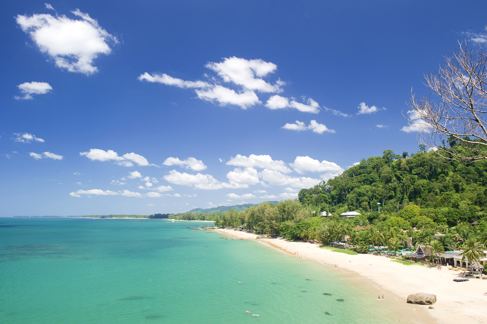
The coastal section combines sand, rocks, rocky headlands, coastal forest, clear Andaman water and views toward the open sea. Within the national-park section, the landscape retains a more natural character than a typical resort beach. Rocky shoreline and vegetation contribute to the scenery.
A viewpoint around Laem Khao Lak provides a perspective across the coast and sea. This is also where park headquarters is located.
Small Sandy Beach
หาดเล็ก · The Hidden Coastal Corner
One of the most charming features of the park is Small Sandy Beach, or Hat Lek. It is reached from headquarters via a coastal nature trail. Published local information gives the trail distance at roughly 1.4–2 kilometres, depending on the point measured and route description.
The trail follows the coastline through forest and rocky terrain before arriving at a smaller sandy beach. That transition is precisely what makes the experience special.
You begin beside the Andaman Sea. Then the trail disappears into vegetation. You hear waves through the trees. The forest opens. And suddenly a small beach appears. It feels considerably more secluded than the major beaches of the Khao Lak resort area.
The park’s coastal section contains both rocky and sandy shoreline. Nearshore coral communities have also been reported around suitable coastal areas. Rocky headlands create different microhabitats for marine organisms and coastal species — a marine environment that differs from the broad sandy beaches commonly associated with the wider Khao Lak tourism region.
The Park vs. the Khao Lak Tourism Region
This distinction is essential for an accurate destination guide.
Khao Lak is a much larger tourism destination than Khao Lak–Lam Ru National Park. The wider region includes numerous beaches, resorts, restaurants, communities and coastal attractions outside the legal boundary of the park. Places such as Bang Niang, Nang Thong, Khuekkhak and other resort beaches should therefore not automatically be described as being inside the national park.
The national park is one important component of the wider Khao Lak destination — particularly its forest, mountain, waterfall and protected coastal landscape.
- Khao Lak
- The wider destination: long sandy beaches, hotels, restaurants and coastal communities stretching well beyond the park.
- Khao Lak–Lam Ru National Park
- The legally protected landscape of about 78,125 rai / 125 km². Less about resorts. More about forest + rocks + sea + silence.
The Tourism Authority of Thailand describes the wider Khao Lak coastline as a long coastal stretch with sandy beaches, trees and scattered rock formations, suited to swimming and water-based activities. The national-park section feels different.
The 2004 Indian Ocean Tsunami
Khao Lak is also part of one of the most significant modern chapters in Thailand’s coastal history. On 26 December 2004, the Indian Ocean earthquake and tsunami struck the Andaman coast. Khao Lak was among the areas in Thailand most severely affected.
The disaster transformed the physical and social landscape of the region and became an important part of Khao Lak’s contemporary identity. Today the region has been extensively rebuilt, while memorial sites and community initiatives preserve the memory of the event.
This history is worth acknowledging because the landscape visitors see today exists within a larger story of nature, vulnerability, recovery and resilience.
How to Experience Khao Lak–Lam Ru
The park is particularly suited to travellers who want more than a conventional beach holiday. Possible experiences include coastal walking around headquarters and toward Small Sandy Beach; waterfall exploration at Ton Chong Fa, Lam Ru and other systems; early-morning birdwatching; looking for tracks, calls, insects and butterflies; forest photography; and nature interpretation — understanding how a tropical forest connects mountains, rivers and the sea.
Khao Lak–Lam Ru should not be treated as a checklist destination. Its strongest experience comes from combining different environments in a single day:
- Morning
- Begin in the forest. The air is cooler, birds are more active and light enters the canopy at a lower angle.
- Midday
- Move toward a waterfall or stream. The forest becomes darker, wetter and cooler.
- Afternoon
- Return toward the coast. The vegetation opens. The sound of flowing water is replaced by waves.
- Late afternoon
- Walk along the Khao Lak coastal section and watch the light change across the Andaman Sea.
Mountain → Forest → Waterfall → Trail → Beach → Sea.
When to Visit
Khao Lak–Lam Ru sits on Thailand’s Andaman coast and receives substantial seasonal rainfall. Different experiences are strongest at different times.
- December–January
- Often particularly attractive for waterfall scenery. Ton Chong Fa is specifically noted in local tourism information as being especially beautiful during this period.
- Drier months
- Generally more comfortable for coastal walking, photography and outdoor exploration.
- Rainy season
- The forest becomes intensely green and waterfalls can become much more powerful. Wet trails, slippery rocks and strong currents can make some activities unsafe.
The park has historically published a seasonal closure period for tourism and overnight stays. Current closure dates and access conditions should always be checked directly with the park before visiting, because operating rules can change.
How to Get There
Park headquarters sit on the Khao Lak coast in Khuekkhak, Takua Pa District, Phang Nga 82190, along Highway 4 (Phet Kasem Road). Published local tourism information places the office approximately 33 kilometres south of Takua Pa town.
- From Phuket
- Drive north along Highway 4 toward Thai Mueang and the Khao Lak / Takua Pa coast. This is the most common approach for visitors arriving via Phuket International Airport.
- From Takua Pa
- Follow Highway 4 south for about 33 kilometres to Khuekkhak. Headquarters is on the coastal side of the national park, not in the inland waterfall forest.
- Once you arrive
- The coastal trail to Small Sandy Beach (Hat Lek) begins near headquarters. Ton Chong Fa, Lam Ru and other waterfalls are inland — ask rangers for current access, because trail conditions change with rainfall.
ThailandLover treats this as a nature destination rather than a resort transfer. Allow time for forest walking, not only a roadside photo stop.
Responsible Travel
Khao Lak–Lam Ru is a protected landscape, not simply an outdoor recreation venue.
- Carry all rubbish out
- Never feed wildlife
- Never collect plants, shells, rocks or other natural materials
- Stay on designated trails
- Avoid loud music
- Do not approach wild animals
- Do not enter closed areas
- Follow ranger instructions
- Take particular care around waterfalls and wet rocks
- Avoid swimming where currents are strong
- Use reef-safe and environmentally responsible practices around coastal areas
- Avoid single-use plastic wherever possible
The most valuable souvenir is not something taken from the park. It is the memory of the landscape left exactly where you found it.
Within the Wider Phang Nga Landscape
Khao Lak–Lam Ru should also be understood within the larger geography of Phang Nga. To the north and east are major forest and watershed systems. To the west lies the Andaman Sea. Further offshore are some of Thailand’s most famous marine protected areas.
Mainland rainforest → coastal national park → Andaman Sea → offshore islands and marine ecosystems.
For travellers, Khao Lak can function as a gateway to multiple types of nature experiences. Khao Lak–Lam Ru itself remains distinctly mainland and forest-oriented.
Thailand has many spectacular national parks — some famous for limestone cliffs, some dominated by islands, some known for enormous waterfalls, some primarily mountain destinations. Khao Lak–Lam Ru is different because of its compact ecological transition:
High mountain → evergreen rainforest → streams and waterfalls → coastal forest → rocky headlands → sandy beaches → Andaman Sea.
That continuity is the park’s defining character.
Must-Experience
- 01 — Khao Lak Beach
- Experience the national park where forest meets the Andaman Sea.
- 02 — Laem Khao Lak
- Walk toward the rocky headland and look back across the coast.
- 03 — Small Sandy Beach
- Follow the coastal trail to one of the quieter beaches within the park.
- 04 — Ton Chong Fa Waterfall
- Explore the park’s signature multi-level waterfall system.
- 05 — Lam Ru Waterfall
- Discover the five-level waterfall surrounded by humid southern rainforest.
- 06 — Forest Trails
- Slow down and experience the biodiversity rather than simply passing through.
- 07 — Birdwatching
- Come early, stay quiet and let the forest reveal itself.
- 08 — Sunset by the Andaman Sea
- End the day where the protected forest meets the open ocean.
Essential Khao Lak–Lam Ru
- Name
- Khao Lak–Lam Ru National Park
- Thai
- อุทยานแห่งชาติเขาหลัก–ลำรู่
- Province
- Phang Nga
- Coast
- Andaman Sea
- Area
- 78,125 rai / approximately 125 km²
- Highest Point
- Approximately 1,077 metres
- Established
- 30 August 1991 · 66th national park
- Districts
- Takua Pa, Kapong, Thai Mueang and Mueang Phang Nga
- Main Forest
- Moist evergreen forest
- Coastal Ecosystems
- Beach forest, sandy beach, rocky coast and mangrove environments
- Main Waterfalls
- Ton Chong Fa, Lam Ru, Lam Phrao and Hin Lat
- Main Coastal Sites
- Khao Lak Beach and Small Sandy Beach
- Headquarters
- Khuekkhak, Takua Pa, Phang Nga 82190
- Access
- Highway 4 (Phet Kasem Road) · about 33 km south of Takua Pa town
Frequently Asked Questions
- What is Khao Lak–Lam Ru National Park?
- Thailand’s 66th national park, gazetted on 30 August 1991 in Phang Nga. About 78,125 rai / 125 km² of moist evergreen forest, waterfalls, beach forest and protected Andaman coastline, with a highest elevation of about 1,077 metres.
- Is the entire Khao Lak tourism area inside the park?
- No. Khao Lak is a much larger destination. Resort beaches such as Bang Niang, Nang Thong and Khuekkhak should not automatically be described as being inside the park boundary.
- What is the signature waterfall?
- Namtok Ton Chong Fa, a multi-level cascade in rainforest behind the Khao Lak area. Local information commonly describes seven levels; the lower and middle sections are the most accessible. The fourth level is associated with a drop of about 200 metres. Upper sections may require a ranger or guide.
- When is the best time to visit?
- December–January is often especially beautiful for waterfall scenery. Drier months are generally more comfortable for coastal walking. The rainy season makes the forest intensely green, but trails and rocks can be unsafe. Check current access with the park.
- How do I reach Small Sandy Beach?
- Hat Lek is reached from park headquarters by a coastal nature trail of roughly 1.4–2 kilometres through forest and rocky shoreline.
- Where is park headquarters?
- Moo 7, Khuekkhak, Takua Pa District, Phang Nga 82190, along Highway 4 (Phet Kasem Road), about 33 kilometres south of Takua Pa town according to published local tourism information.
- Can I expect to see large wildlife?
- The park is biologically rich, but large mammals are elusive. A realistic visit is more often birds, butterflies, insects, tracks and forest sound than close wildlife photography.
- How do I get there from Phuket?
- Drive north from Phuket along Highway 4 (Phet Kasem Road) toward the Khao Lak / Takua Pa coast. Headquarters are in Khuekkhak, Takua Pa District, Phang Nga 82190, about 33 kilometres south of Takua Pa town according to published local tourism information.
- Do I need a national park ticket?
- Yes. Headquarters, coastal trails, Khao Lak Beach within the park, Small Sandy Beach and the waterfall areas sit inside the national park. Official DNP fees can change — confirm current rates with the park before travelling.
- What is Small Sandy Beach or Hat Lek?
- Hat Lek is a quieter sandy cove inside the park, reached from headquarters by a coastal nature trail of roughly 1.4–2 kilometres through forest and rocky shoreline. It is more secluded than the major resort beaches of the wider Khao Lak destination.
- How do I contact the park?
- DNP lists 0 7648 5243 and khaolaklumru.dnp@gmail.com. Headquarters are at Moo 7, Khuekkhak, Takua Pa, Phang Nga 82190.
Related Destinations
- Ao Phang Nga National Park
- Limestone karst, mangroves and sea-caves — another protected face of the same province.
- Si Phang-nga National Park
- Inland rainforest and waterfalls in northern Phang Nga, a mountain counterpart to the Khao Lak coast.
- Khao Sok National Park
- One of southern Thailand’s great rainforest landscapes, inland from the Andaman coast.
- Hat Noppharat Thara–Mu Ko Phi Phi National Park
- Andaman beaches and islands further south — the marine continuation of this coast.
- Nature & Parks
- More protected landscapes across ThailandLover’s national-park collection.
Location
Find Khao Lak–Lam Ru National Park
Moo 7, Khuekkhak Subdistrict, Takua Pa District, Phang Nga 82190