


Park Spotlight · Southern Thailand
Namtok Si Khit National Park
อุทยานแห่งชาติน้ำตกสี่ขีด
Where Limestone Meets the Rainforest
Nakhon Si Thammarat & Surat Thani
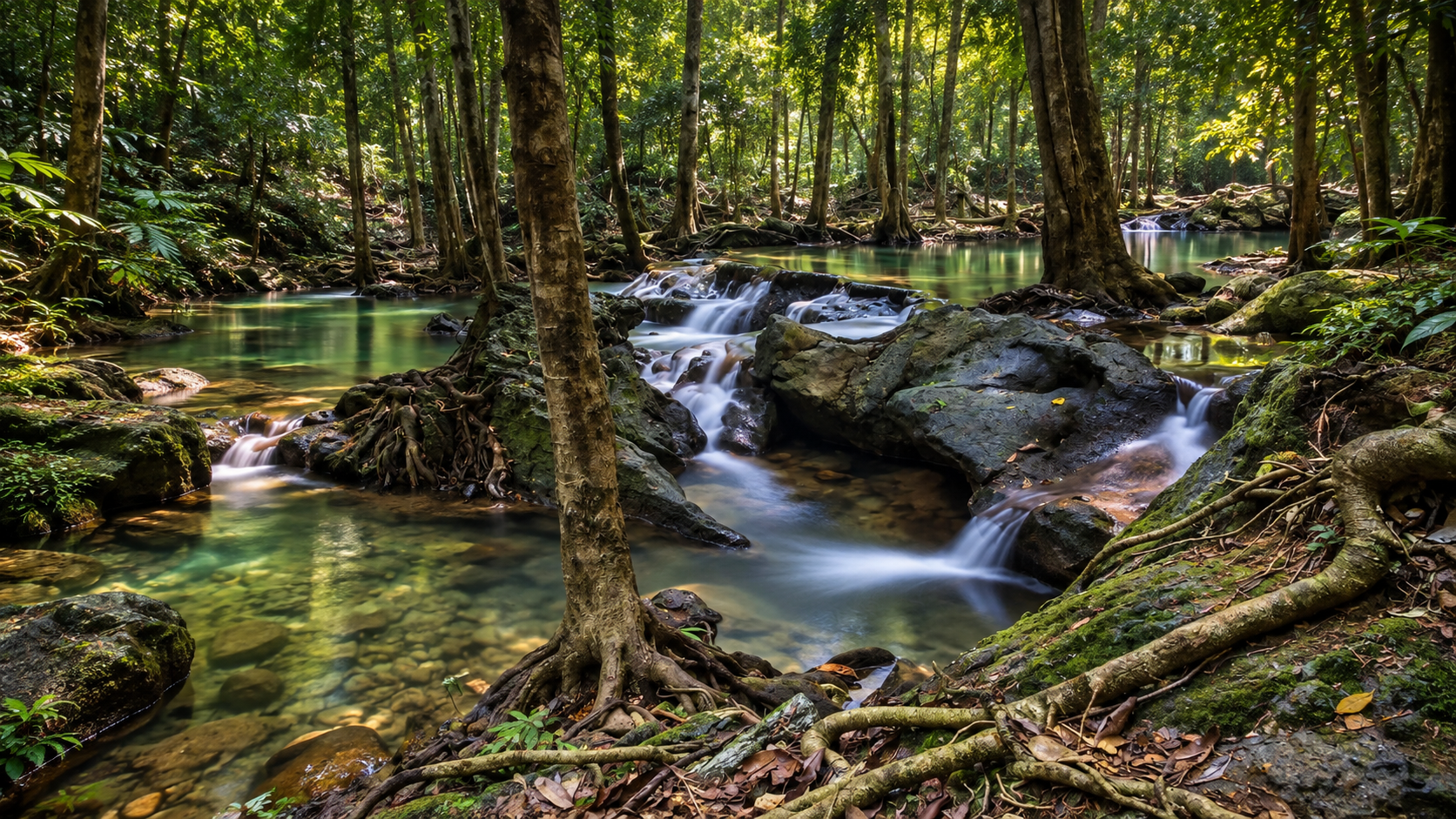
A landscape shaped by water — where mountain rain becomes forest streams, limestone pools and emerald waterfalls.
Where Limestone Meets the Rainforest
Namtok Si Khit National Park is a mountainous protected area in southern Thailand, stretching across Sichon District, Nakhon Si Thammarat, and Kanchanadit District, Surat Thani.
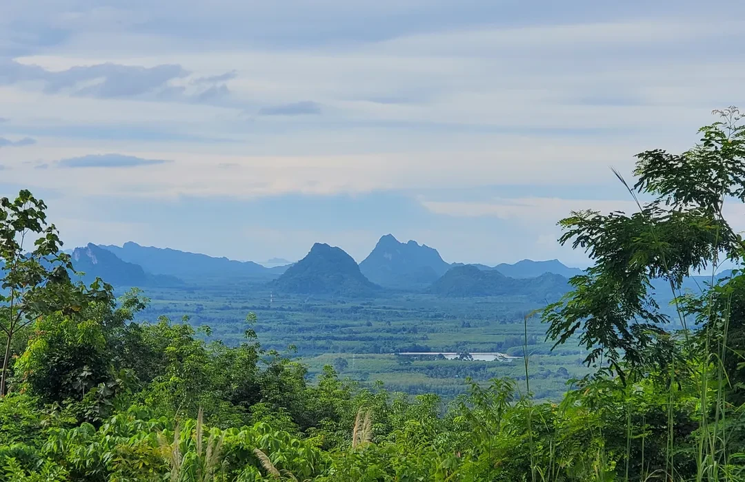
Set within the rugged Nakhon Si Thammarat mountain range, the park is a landscape of steep forested mountains, limestone formations, streams, caves and waterfalls.
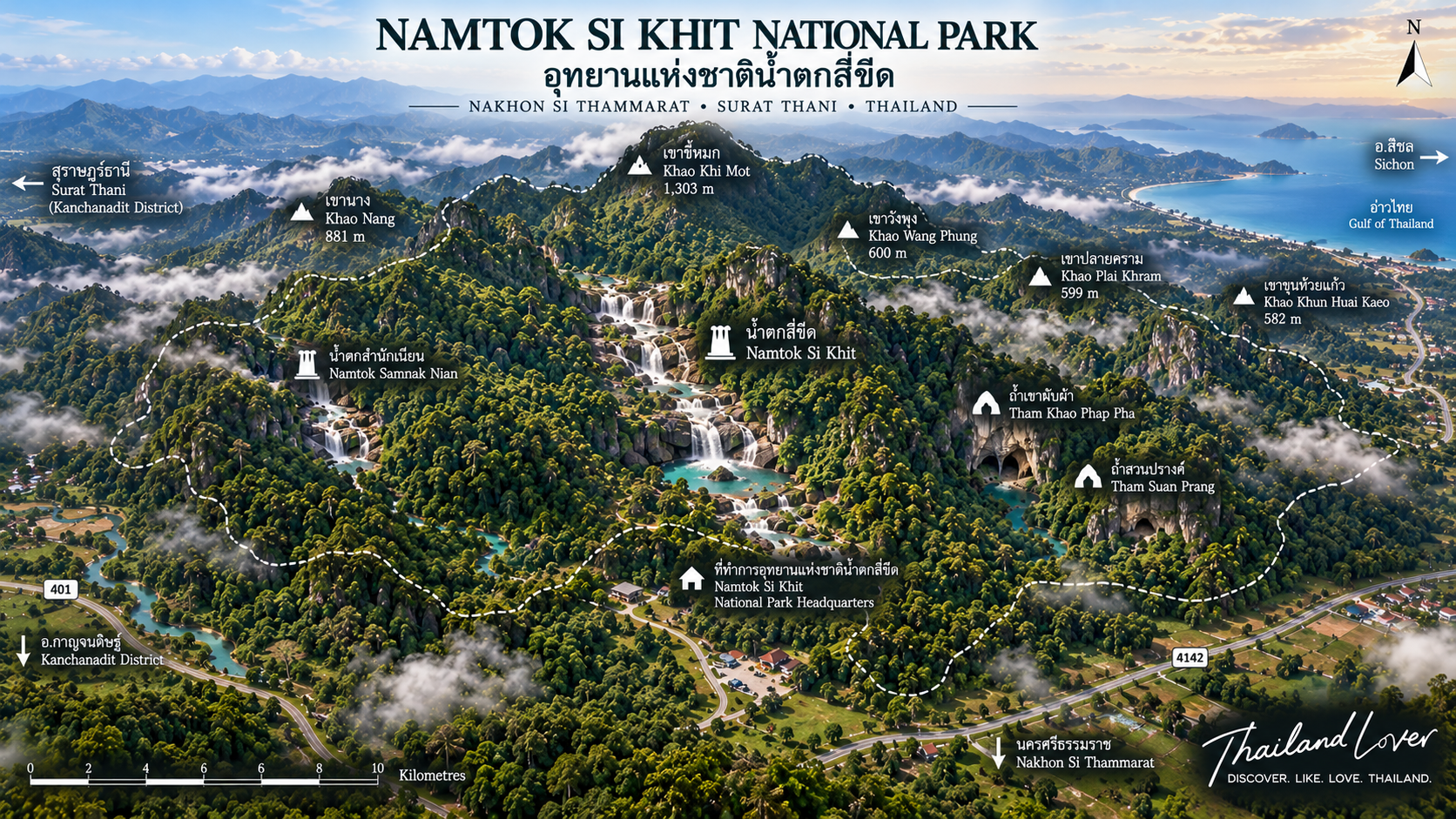
At its heart is Namtok Si Khit, a limestone waterfall known for its clear, emerald-green pools and broad natural rock formations. Above the surrounding forests rises Khao Khi Mot, the highest mountain in the park at approximately 1,303 metres above sea level.
Mountain → Forest → Stream → Limestone → Waterfall → Pool
Rain falls across the mountains, gathers in the forest, moves through valleys and limestone formations, and eventually becomes the streams and waterfalls that define the park.
For travellers looking beyond Thailand’s famous beaches, Namtok Si Khit offers a different side of the southern peninsula — quieter, greener and deeply connected to the mountain forests that feed the region’s waterways.
At a Glance
- 145 km²
- Approximately 90,625 rai across two southern provinces.
- 17 June 1999
- Officially established as a national park.
- 1,303 m
- Khao Khi Mot — the highest peak in the park.
- Emerald pools
- Namtok Si Khit — limestone waterfall and clear mountain water.
- Official English name
- Namtok Si Khit National Park
- Thai name
- อุทยานแห่งชาติน้ำตกสี่ขีด
- Region
- Southern Thailand
- Provinces
- Nakhon Si Thammarat and Surat Thani
- Districts
- Sichon and Kanchanadit
- Main attraction
- Namtok Si Khit
- Highest peak
- Khao Khi Mot
- Highest elevation
- Approximately 1,303 metres
- Landscape
- Mountains, rainforest, limestone, caves, streams and waterfalls
- Water environment
- Mountain streams and forest waterways
- Park headquarters
- Si Khit Subdistrict, Sichon, Nakhon Si Thammarat
- Postal code
- 80120
- Established
- 17 June 1999
- Approximate area
- 90,625 rai · approx. 145 km²
The park was officially established as a national park on 17 June 1999. Published government and tourism sources place its area at approximately 90,625 rai, equivalent to about 145 square kilometres.
The Landscape
Namtok Si Khit National Park forms part of the Nakhon Si Thammarat mountain range, one of the important mountainous systems of southern Thailand.
The terrain is not a single flat forest. Instead, it consists of rugged mountain ridges, steep slopes, valleys, limestone formations and forested watersheds. The central mountain areas form an important watershed. The highest point is Khao Khi Mot, rising to approximately 1,303 metres above sea level.
Other notable mountain elevations reported for the park include:
- Khao Nang — approximately 881 metres
- Khao Wang Phung — approximately 600 metres
- Khao Plai Khram — approximately 599 metres
- Khao Khun Huai Kaeo — approximately 582 metres
The mountain system also functions as a natural divide between the Nakhon Si Thammarat and Surat Thani sides of the landscape. Because of its elevation, humidity and dense forest cover, the mountains generate numerous streams and waterways. These streams descend through valleys and limestone terrain, creating waterfalls, pools and small cascades throughout the park.
A Forest Built by Water
One of the defining characteristics of Namtok Si Khit is the relationship between forest, limestone and water.
The park contains areas of moist evergreen forest and montane forest, together with secondary forest and limestone landscapes. The mountains capture rainfall and release it gradually through streams and small waterways.
The result is a landscape that changes dramatically with rainfall. During wetter periods, streams become more energetic and waterfalls become fuller. During drier conditions, exposed limestone formations, pools and streambeds become more visible.
For visitors, the character of the same waterfall can change considerably depending on the season and recent rainfall.
Namtok Si Khit — The Emerald Waterfall
The signature attraction of the park is Namtok Si Khit, a limestone waterfall located around the Tha Khok stream area.
Unlike a waterfall defined only by a single vertical drop, Namtok Si Khit is part of a longer natural water system in which water moves through limestone formations, rock pools and cascading sections.
The first major section of the waterfall is described as beginning at a cliff approximately 60 metres high, after which the water continues through a much longer limestone stream system. Local and tourism sources describe the watercourse as extending for approximately 12 kilometres — this should not be interpreted as the length of a visitor walking trail or the vertical height of the waterfall.
The limestone landscape creates broad rock surfaces and natural pools, while the surrounding evergreen forest provides shade and a cool atmosphere. One of the most visually distinctive features is the emerald-green appearance of the water, particularly in suitable light and water conditions.
Why the water looks emerald green
The distinctive colour is closely associated with clear mountain water, limestone geology, natural pools and surrounding forest. It can appear particularly vivid when sunlight reaches clear water over pale limestone.
Water colour is naturally variable. Rainfall, sediment, sunlight, water depth and seasonal conditions all influence how the pools appear on a particular day. The emerald-green look is a characteristic visual feature — not a colour that can be guaranteed throughout the year.
Limestone Landscapes
Limestone is one of the most important geological features of the park. Parts of the mountain landscape are composed of limestone, creating rock terraces, natural pools, cliffs, caves, stalactites and stalagmites, narrow stream passages and unusual rock formations.
The interaction between limestone and flowing water has shaped many of the park’s most distinctive natural features. It also explains why the park is more than simply a waterfall destination — it is a landscape where geology, hydrology and rainforest ecology are closely connected.
Khao Khi Mot
Rising to approximately 1,303 metres above sea level, Khao Khi Mot is the highest peak within Namtok Si Khit National Park.
Its forested slopes form part of the watershed system that supplies streams flowing through the surrounding landscape. Higher elevations also create cooler and wetter environmental conditions than the lowlands, supporting different forest characteristics and contributing to the ecological diversity of the park.
The mountain environment is considerably more remote and demanding than the easily accessible waterfall area. Visitors interested in deeper forest exploration should treat mountain routes as a separate wilderness experience rather than an extension of a normal waterfall visit.
Caves of Namtok Si Khit
The limestone geology has created a number of caves throughout the park. Two notable cave environments are Tham Khao Phap Pha and Tham Suan Prang; another associated feature is Tham Khoram.
- Tham Khao Phap Pha
- Located approximately 5 kilometres from park headquarters. A relatively small limestone cave with stalactites and stalagmites, extending roughly 50 metres from its entrance according to published tourism information. Do not enter independently where official access requires a guide.
- Tham Suan Prang
- A larger limestone cave associated with the Suan Prang area. Traditionally described as a habitat for bats — dark, enclosed and shaped by groundwater moving through limestone. Avoid touching formations or disturbing wildlife.
- Tham Khoram
- Situated in a steep limestone cliff area around the Suan Prang ranger station. Historical descriptions note views over the surrounding forest and an association with serow habitat — the Thai name Khoram connects with the local name for the serow. Treat the area primarily as protected habitat rather than a wildlife-viewing attraction.
Other Waterfalls
Namtok Nong Thong
A multi-level waterfall hidden within the forest, with approximately seven tiers. Deeper than the main Si Khit visitor area — approach according to current park access conditions and staff guidance.
Namtok Phu Rin
A waterfall environment fed by streams through limestone terrain, with natural waterways that provide habitat for aquatic organisms. Check with park staff before planning a visit.
The park’s waterfalls are not simply one attraction — they are components of a larger mountain watershed.
Forest & Biodiversity
Namtok Si Khit is part of an important forest landscape in southern Thailand. Its combination of high mountains, evergreen forest, limestone terrain, streams, caves, valleys and watersheds creates a variety of habitats within a relatively compact area.
Published descriptions identify vegetation including members of the Dipterocarp family, ironwood-related species, Hopea, and other southern Thai forest trees.
The park has also been associated with wildlife including serow, Malayan tapir, wild boar, deer, barking deer, various bird species and other forest wildlife. Sightings are never guaranteed — wild animals are naturally elusive, and much of their value lies in their existence within the protected ecosystem.
The Southern Rainforest Experience
For international travellers, one of the most interesting aspects of Namtok Si Khit is the chance to experience mainland southern Thailand’s rainforest landscape away from the coastal resort environment.
Southern Thailand is often introduced through beaches, islands and marine parks. Namtok Si Khit tells a different story.
Deep green forest. Mountain mist. Limestone cliffs. Clear streams. Waterfalls. Caves. Rain.
It is a destination for travellers who want to see the ecological landscape behind the famous beaches.
Things to Do
- 1. Visit Namtok Si Khit
- Walk around the waterfall area, observe the limestone formations and rest beside the stream. Where swimming is officially permitted and conditions are safe, natural pools can offer a cool-off.
- 2. Photograph the limestone pools
- Pale limestone, clear water and dense green vegetation create strong compositions — water over rock, emerald pools, forest reflections, moss textures and cascades. Morning and late afternoon generally give softer light.
- 3. Explore the forest
- Short walks introduce the forest without a major trek. Longer routes only where officially permitted — and with park staff or guides where required.
- 4. Explore limestone caves
- Tham Khao Phap Pha and Tham Suan Prang show the geological side of the park. Always follow current rules; some caves may require a guide or may be closed.
- 5. Experience the mountain forest slowly
- Listen to the stream. Watch water move over limestone. Observe birds and insects. Notice how vegetation changes as the terrain rises.
Swimming
Namtok Si Khit contains natural pools where swimming has traditionally been possible. However, natural waterfalls are not controlled swimming pools.
- Water levels and currents can change rapidly after heavy rain
- Rock surfaces can become slippery
- Apparently calm pools may contain uneven depths or submerged rocks
- Swim only where the park officially permits it
- Do not enter the water during heavy rainfall or when officials have restricted access
Best Time to Visit
The character of Namtok Si Khit changes with rainfall. Southern Thailand has a different rainfall pattern from northern and central Thailand — do not assume the classic Thai dry-season calendar applies equally here.
Wetter periods
Waterfalls become more powerful, streams fuller, pools more dramatic, and forest vegetation especially lush.
Drier periods
Some streams become gentler, rock formations more visible, and waterfall intensity may decrease.
For waterfall photography, recent rainfall is often more important than the calendar alone.
Rainy-season considerations
Rain can transform the park into a spectacular landscape — and change the safety conditions. After heavy rain, water levels can rise quickly, currents strengthen, rocks become slippery, trails muddy, cave access restricted, and some routes temporarily closed.
Getting There
From Nakhon Si Thammarat
Headquarters are in Si Khit Subdistrict, Sichon District. One commonly described route follows Highway 401 toward Sichon, then continues toward Si Khit. Published local information places the park approximately 69 kilometres from Nakhon Si Thammarat city, followed by a turn toward Si Khit and about 15 kilometres onward to the park area.
From Surat Thani
Travellers can also approach via Highway 401. Published local information describes roughly 52 kilometres from Surat Thani city to the Khao Hua Chang junction, then about 10 kilometres toward the park. Actual times depend on traffic, road conditions and your starting point.
Location
Namtok Si Khit National Park
Moo 2, Si Khit Subdistrict
Sichon District
Nakhon Si Thammarat 80120
Thailand
The park’s wider protected landscape extends across the provincial boundary into Kanchanadit District, Surat Thani.
Visitor Facilities & Camping
Facilities associated with the park include visitor services, parking, toilets, welfare shops and camping areas. Published local information has identified camping around the park headquarters, Suan Prang ranger station and Namtok Phu Rin. A welfare shop at headquarters has also been reported.
Facilities and opening arrangements can change seasonally. Before camping, confirm whether camping is open, which zone is operating, whether advance reservation is required, whether tents are available for rent, current fees and seasonal closures.
Responsible Travel
Namtok Si Khit is not simply a recreational waterfall. It is a protected mountain ecosystem.
- Leave no trace — take rubbish out with you
- Protect the water — no soap, shampoo or chemicals in streams or pools
- Respect wildlife — do not feed, chase or bait animals for photographs
- Protect limestone — do not scratch, break or remove formations
- Stay on permitted routes — trails protect both visitors and habitats
- Keep the forest quiet — avoid loud music and unnecessary noise
- Follow ranger instructions — temporary closures usually relate to safety, weather, wildlife or management
Photography Guide
- Wide landscape
- Use the waterfall with surrounding forest to communicate scale.
- Detail
- Water textures, limestone surfaces, leaves, moss, small cascades and reflections.
- Human scale
- A person placed carefully in the frame can show the size of the limestone and forest.
- Best light
- Soft morning or late-afternoon light reveals texture without harsh midday contrast.
What Makes Namtok Si Khit Different?
Thailand has many famous waterfalls. Namtok Si Khit stands apart because its identity is not based on a single dramatic drop. Its character comes from the interaction of several landscapes:
Mountain + Rainforest + Limestone + Stream + Cave + Waterfall
The waterfall is the entrance to a much larger story. The mountains collect the rain. The forest holds the water. The limestone shapes its route. The streams carry it downhill. And the waterfalls reveal the journey.
Suggested One-Day Experience
- Morning — arrive and begin at the main visitor area; explore Namtok Si Khit’s limestone formations and pools while light is still soft
- Midday — rest in the shaded forest; lunch according to current facilities; avoid leaving food waste around the waterfall
- Afternoon — another permitted nearby attraction or short trail; if caves are open, follow official guidance
- Late afternoon — return to the main visitor area; leave before closing and before weather deteriorates
Travel Tips
Bring
- Drinking water, comfortable walking shoes, quick-drying clothing
- Swimwear if swimming is permitted
- Insect repellent, sun protection, waterproof bag
- Camera protection, small first-aid supplies
During rain & caves
- Lightweight rain jacket or poncho
- Protect phones and cameras from sudden rain
- Shoes with good grip for caves
- Never assume a pool is safe because others are swimming
Essential Information
- Name
- Namtok Si Khit National Park
- Thai
- อุทยานแห่งชาติน้ำตกสี่ขีด
- Region
- Southern Thailand
- Provinces
- Nakhon Si Thammarat and Surat Thani
- Districts
- Sichon and Kanchanadit
- Main attraction
- Namtok Si Khit
- Highest peak
- Khao Khi Mot · approx. 1,303 m
- Landscape
- Mountain rainforest, limestone, caves, streams and waterfalls
- Area
- Approx. 90,625 rai / 145 km²
- National park designation
- 17 June 1999
- Headquarters
- Si Khit Subdistrict, Sichon, Nakhon Si Thammarat 80120
Frequently Asked Questions
- Where is Namtok Si Khit National Park?
- In southern Thailand, covering Sichon District, Nakhon Si Thammarat and Kanchanadit District, Surat Thani.
- What is Namtok Si Khit famous for?
- Its limestone waterfall, clear emerald-green pools, forested mountain landscape and limestone caves.
- How high is the highest mountain?
- Khao Khi Mot, approximately 1,303 metres above sea level.
- Can you swim at Namtok Si Khit?
- Traditionally yes in designated pools — but conditions change with rainfall and restrictions. Follow park officials.
- Are there caves?
- Yes — including Tham Khao Phap Pha, Tham Suan Prang and Tham Khoram.
- Can I go hiking?
- Nature trails and remote trekking exist. Access varies; demanding routes need preparation and official guidance.
- Can I camp overnight?
- Camping has historically been available near headquarters and ranger stations. Confirm availability before travelling.
- When is the best time to see the waterfall?
- Generally after rainfall — but heavy rain can also create dangerous conditions. Check weather and park announcements.
- Is it suitable for international travellers?
- Yes — especially for rainforest, waterfalls, limestone landscapes and a quieter side of southern Thailand beyond the beaches.
More Southern Thailand Nature
- Namtok Yong National Park
- Another Nakhon Si Thammarat waterfall landscape in the same southern mountain belt.
- Tai Rom Yen National Park
- Mountain rainforest and waterfalls across the Surat Thani–Nakhon Si Thammarat borderlands.
- Khao Sok National Park
- The iconic southern rainforest and lake landscape further west in Surat Thani.
- Si Phang-nga National Park
- Evergreen forest and waterfalls on the Andaman side of the peninsula.
- All Nature & Parks
- Browse ThailandLover’s national park guides across the country.
Location
Find Namtok Si Khit
Moo 2, Si Khit Subdistrict, Sichon District, Nakhon Si Thammarat 80120 — extending into Kanchanadit, Surat Thani