


Preparatory Area · Mae Hong Son
Mae Sariang National Park
อุทยานแห่งชาติแม่สะเรียง (เตรียมการ)
The Mountains Above the Yuam Valley
Mae Sariang · Doi Lak Saen · Morning mist
A quieter part of Mae Hong Son, where the landscape itself is still the main attraction — and the future of tourism has not yet been decided.
A Destination Still Becoming a Destination
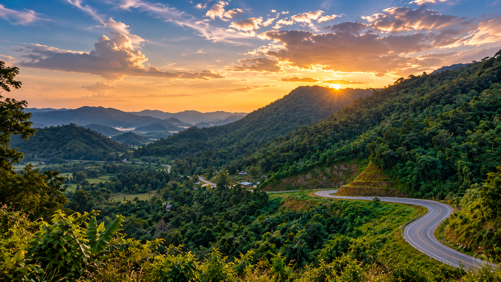
Some places in the north are famous before you arrive. Mae Sariang is different. Ridges rise above the town. Forest covers steep ground. Small communities sit between valleys and hills. In the cool season, mist can gather on the mountains before the first light reaches the valley.
Among these landscapes is the area now known as Mae Sariang National Park (Preparatory Area). It is not yet a fully gazetted national park. That distinction matters. This is a landscape in transition — conservation planning, forest protection, community livelihoods and future nature tourism being considered together.
You are not coming to a finished national-park product. You are coming to a quieter part of Mae Hong Son, where the country is still the point.
First: What This Place Is
Government agencies refer to it as Mae Sariang National Park (Preparatory Area) — อุทยานแห่งชาติแม่สะเรียง (เตรียมการ). It is being managed and studied in preparation for establishment. It should not be written as if it already has the same legal status as a park created by a completed Royal Decree.
The Department of National Parks has undertaken management planning for the area, including a five-year plan for 2023–2027 and public consultation with affected communities, stakeholders and local agencies. The landscape includes both conservation land and communities whose livelihoods are tied to the surrounding forest.
At a Glance
- Preparatory
- Managed toward establishment. Not a finished park.
- ~1,139 m
- Doi Lak Saen — the highest mountain identified in the preparatory area.
- ~2 km
- From Ban Huai Pu, Mae Ho Subdistrict, to the mountain.
- Mist, not a promise
- Cool-season mornings, when the valley agrees.
- Thai name
- อุทยานแห่งชาติแม่สะเรียง (เตรียมการ)
- English name
- Mae Sariang National Park (Preparatory Area)
- Province
- Mae Hong Son
- Main area
- Mae Sariang District and the surrounding mountains
- Administration
- Mae Hong Son Conservation Area Administration Office 16, Mae Sariang Branch
- Status
- National park preparatory area
- Signature mountain
- Doi Lak Saen · ดอยหลักแสน · about 1,139 m
- Location of the mountain
- Near Ban Huai Pu, Mae Ho Subdistrict, Mae Sariang
- Landscape
- Steep mountains, forest, ridges, valleys and watersheds
- Tourism character
- Emerging, low-density, nature-oriented
- Best general experience
- Mountain scenery, cool-season mist, quiet nature
Why Mae Sariang Matters
It is interesting precisely because it has not become a mainstream park destination. There is no need to pretend every ridge is a viewpoint, and no need for a long list of commercial attractions. What dominates is ridges, forest, valleys, streams, small communities, agricultural land, and the changing atmosphere of the northern seasons.
That suits travellers who prefer places still connected to the country around them. Mae Sariang is unlikely to compete with major parks on the number of attractions. Its strength is landscape character. There may not be dozens of developed viewpoints, a large visitor centre, or resort infrastructure. The attraction is the environment itself.
The Landscape
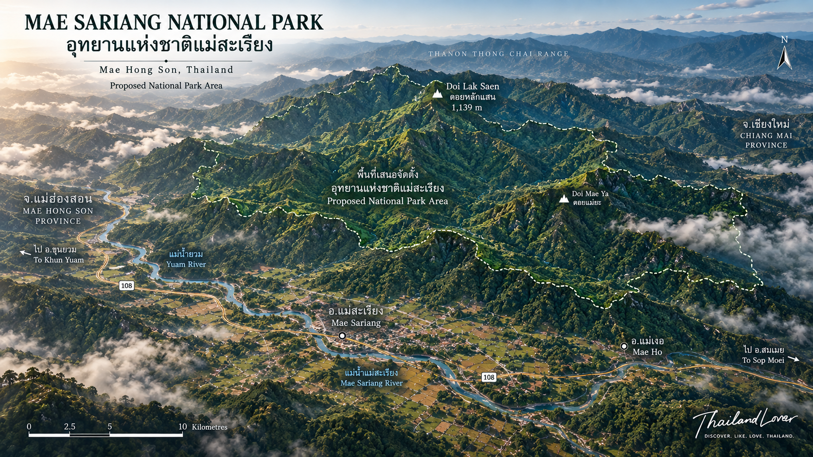
This is the mountainous west of Northern Thailand. The terrain is hilly to mountainous. Some of it is steep and difficult. It is not a flat farming plain with a few hills stuck on. It is ridge after ridge, valley after valley, with settlement and cultivation where the ground allows.
The ruggedness is not a marketing line. In 2026, officials working in the preparatory area reported wildfire operations in steep mountain terrain where some fire fronts could not be reached on foot. The country is genuinely mountainous.
The broader landscape is associated with the Mae Yuam and Mae Sariang waterways. Valleys hold some of the flatter land suitable for settlement and fields. The chain that explains the region is mountain, forest, stream, valley, community. Rain falls on the ridges. Forest slows the water. Small streams descend. Downstream agriculture, soil and ecosystems depend on that. Conserving forest here is not only about trees. It is about water.
Doi Lak Saen
ดอยหลักแสน · about 1,139 m · near Ban Huai Pu
If the preparatory area has one emerging signature, it is Doi Lak Saen. At about 1,139 metres it is the highest mountain identified in the area being prepared for establishment. It stands about 2 kilometres from Ban Huai Pu, Mae Ho Subdistrict, Mae Sariang District.
The Department of National Parks surveyed the mountain specifically to evaluate its potential as a future tourism destination and to study its recreational carrying capacity. That wording matters. It was being studied for future development. It should not be presented as a fully built public viewpoint with guaranteed facilities.
From the mountain, the view is toward Mae Sariang below and across the surrounding ranges. In the cool season it can offer broad layers of morning mist — town and valley under cloud, higher ridges above it. The sequence is mountain, mist, valley, town. The Department identified that potential: wide views over Mae Sariang, and sea-of-mist conditions in winter.
The elevation also makes it a possible sunrise point. Because it has been described as an area under study, confirm current access rather than assuming a developed sunrise viewpoint is permanently open.
The survey of Doi Lak Saen was not a sightseeing trip. Officials were studying tourism potential and how many visitors the landscape can sustainably hold. A destination does not have to become crowded before it becomes valuable. The better question is not how many people can be brought up. It is how many the mountain can hold without losing what makes it worth the climb.
A Seasonal Forest
The preparatory area sits in the wider forest of Mae Hong Son. That forest matters for watersheds, soil, wildlife, livelihoods, and fire. Cover on steep ground is what slows erosion and protects headwaters.
- June – October · green season
- Lush vegetation, cloud on the ridges, streams answering the rain. Often the most atmospheric time for landscape photography. Roads and trails get harder. Landslides can occur. Streams rise quickly. Remote access changes. Flexibility is essential.
- November – February · cool season
- The strongest overall period. Cool mornings, better conditions for viewpoints, a higher chance of mist, comfortable temperatures outside. This is the season most closely tied to Doi Lak Saen.
- March – May · hot season
- Warmer, and often smoky. If the main attraction is a mountain view, haze can erase it. Check air quality and fire conditions before you travel. Dry-forest texture is the compensation, not a clear horizon.
Fire Is Part of the Real Landscape
Mae Sariang should not be written as a pristine fantasy detached from environmental pressure. Forest fire is a major seasonal challenge in Mae Hong Son. In February 2026, officials from the preparatory area and local fire-monitoring teams responded to a hotspot in the Ban Pa Kluai area. The terrain was described as steep and difficult, with some fire near high cliffs.
That is both the ecological importance of the landscape and the physical difficulty of managing it. The practical implication for visitors is simple: do not plan a mountain trip without checking current fire, smoke and air-quality conditions.
Communities and Conservation
One of the important stories around the preparatory area is the relationship between conservation and local communities. Planning has involved public consultation with communities, stakeholders, government agencies and people affected by proposed protected-area management. That is not a minor administrative detail. It is central to the future of the landscape.
Mae Hong Son holds a very large share of forested land. Communities also live and work in and around that forest. The question is not only “protect the forest.” It is how forest conservation and local livelihoods can coexist under a clear and fair framework.
Farming in nearby mountain country can include valley rice, terraces, upland fields and rotational systems. Those practices should not automatically be called destructive. Impact depends on the system, the rotation, the place, fire management and land-use controls. Avoid both “the forest is untouched” and “local farming destroys the forest.” The reality is more complex.
Mae Sariang District has a long history as a settlement and trading area in the western north. Karen / Pgaz K'Nyau communities are particularly important in the wider Mae Sariang–Mae La Noi landscape. The natural country cannot be separated entirely from the people who live around it. The better journey is not only a photograph of the mountains. It is an understanding of people, forest, agriculture, river and ridge together.
What to Do
- 01 · Stand above the valley
- Toward Doi Lak Saen, if access is currently permitted. Check before you travel.
- 02 · Wait for the mist
- Cool season. Early. Not guaranteed. Nature’s bonus, not a booked show.
- 03 · Photograph the layers
- Foreground ridge, middle mountain, mist, far horizon. Morning for mist and soft light. Late afternoon for warm mountain light. Blue hour for silhouettes and valley lights.
- 04 · Walk where walking is allowed
- Slowly, and only on permitted routes. This is not a place to assume every ridge has an established trail.
- 05 · Stay in Mae Sariang
- Do not treat the town as a fuel stop between Chiang Mai and Mae Hong Son. The slower you travel, the more the landscape makes sense.
The Visual Language
The stronger pictures are likely to be mountain layers, morning mist filling valleys, forest texture through the seasons, small settlements and fields set into the valleys, and the road itself. The journey is part of the story. A winding mountain road at the end of the day says as much about this country as a summit does.
Best Experience by Season
- Sea of mist
- November–February
- Mountain photography
- November–February
- Cool-weather walking
- November–February
- Green forest
- June–October
- Clearer visibility
- Generally the cool season, and still weather-dependent
- Dry-forest texture
- Late dry season
- Wildlife
- Year-round, conditions permitting — sightings are not guaranteed
- Cultural exploration
- Year-round
How to Get There
Road distance does not tell the whole story. Mountain roads require patience.
- From Chiang Mai
- The mountain-road network toward Mae Hong Son and Mae Sariang. Long, winding. Allow time for curves, weather, road works, slow vehicles, rain and fog.
- From Mae Hong Son
- Mae Sariang lies south of the provincial town. A substantial mountain journey, and a natural piece of a Mae Hong Son loop.
- From Mae Sot
- The western route up from Tak. Another entry for a longer northern road trip.
A slower circuit — Chiang Mai, Mae Sariang, Mae La Noi, Khun Yuam, Mae Hong Son — shows a different north from the Chiang Mai–Pai line. Quieter. More rural. More mountainous. Less concentrated around mass tourism.
What to Bring, and What to Watch
- Clothing
- Light layers, a warm jacket for winter mornings, a rain jacket in the wet season, long trousers
- Feet
- Comfortable walking shoes; hiking shoes if the ground is rough
- Navigation
- Offline maps, a charged phone, a power bank
- Safety
- A basic kit, water, a headlamp, a way to reach someone
- Do not enter unofficial trails without local guidance. Some ground is steep and remote.
- Heavy rain can mean slippery roads, flash flooding, landslides and difficult trails.
- In the dry season, check PM2.5, local fire alerts, announcements and road conditions.
Responsible Travel
Visitors have a chance to help shape the kind of tourism that develops here.
- Take rubbish with you.
- Do not photograph people or private property without permission.
- Follow local custom at temples, spiritual sites and in villages.
- Stay on permitted routes. Do not cut new trails.
- Watch wildlife from a distance. Do not try to attract animals.
- Do not light fires unless they are explicitly permitted.
- Where it fits, use local guides, food, accommodation and community-based services.
What Happens Next
The protected-area framework is still being developed. Public consultation is already part of the planning. The future depends on balancing conservation, community rights, forest protection, tourism, watersheds, fire management and carrying capacity. That is why ThailandLover does not present Mae Sariang as a finished product. The story is still being written.
The phrase “hidden gem” is overused, and Mae Sariang does not need it. The stronger story is an emerging conservation landscape above a historic northern town, where the future of tourism is being considered alongside conservation and community interests.
Who It Is For
Landscape photographers who like layers, mist and atmosphere. Slow travellers. Independent road-trippers exploring Mae Hong Son beyond the main circuit. People interested in forests, watersheds and mountain environments. Walkers prepared for less-developed terrain, with local guidance. Cultural travellers who want the relationship between landscape and communities.
It is a weaker fit if you want large commercial attractions, luxury park facilities, short easy access to every view, dense nightlife, a guaranteed sea of mist, or guaranteed wildlife. The wider Mae Sariang area can work for families who like scenic road trips. Remote mountain ground and undeveloped trails are not automatically suitable for young children. Facilities in the preparatory area are limited. That is part of the character. It is also, generally, far less built for mass tourism than Pai.
ThailandLover Signature Experiences
- 01 · Stand above the valley
- Toward Doi Lak Saen, looking across the mountains around Mae Sariang.
- 02 · Wait for the mist
- Do not chase the clouds. Arrive early, and let the morning decide.
- 03 · Photograph the layers
- Look past the nearest ridge. This is a landscape of depth.
- 04 · Explore slowly
- Take the roads less hurriedly. Stop where the country asks you to.
- 05 · Notice the people
- The mountains are not empty. Communities have lived in this environment for generations.
- 06 · Travel in the cool season
- November to February is the strongest combination of comfort and mountain atmosphere.
- 07 · Leave the landscape quiet
- The better tourism future may be the kind that does not overwhelm the place.
ThailandLover Quick Verdict
- Mountain scenery
- Ridge after ridge. That is the place.
- Sea of mist potential
- High, in the cool season. Never a guarantee.
- Forest landscape
- Watershed forest on genuinely steep ground.
- Photography
- Layers, mist, roads, and the human landscape in the valleys.
- Road-trip experience
- A different north from the Pai circuit.
- Hiking potential
- Real terrain. Not a signed trail network.
- Wildlife
- Habitat. Sightings are not the product.
- Waterfalls
- Not the reason to come.
- Cultural experience
- If you look past the viewpoint.
- Accessibility
- The town is reachable. The mountain is another question.
- Facilities
- Limited in the preparatory area. Plan for that.
- Family convenience
- Scenic roads yes. Remote trails, not automatically.
- Adventure
- For people who like unfinished edges.
- Slow travel
- The pace that suits it.
- Mass tourism
- Low. The interesting question is whether it stays that way.
Best for: mountain lovers, photographers, independent road-trippers, slow travellers and nature-oriented travellers.
Less suitable for: visitors seeking a highly developed national-park tourism experience.
Frequently Asked Questions
- Is Mae Sariang officially a national park?
- Not yet in the same legal sense as a fully gazetted park. The official term is Mae Sariang National Park (Preparatory Area). It is being managed and planned in preparation for establishment, including a 2023–2027 management plan and public consultation.
- Where is it?
- Mae Sariang District and surrounding mountains in Mae Hong Son. Official reports have also documented operations in areas including Mae Ho Subdistrict in Mae Sariang and Tha Pha Phum Subdistrict in Mae La Noi.
- What is it known for?
- The strongest emerging attraction is Doi Lak Saen, about 1,139 metres, with views across the Mae Sariang landscape and the possibility of a sea of mist in the cool season.
- How high is Doi Lak Saen, and can I visit?
- About 1,139 metres — identified by the Department of National Parks as the highest mountain in the area being prepared for establishment. It is near Ban Huai Pu, Mae Ho, about 2 kilometres from the village. Access should be checked. It has been surveyed for tourism potential and carrying capacity. Do not treat it as a permanently developed public viewpoint.
- Can I see the sea of mist? When should I go?
- Potentially, on cool-season mornings when temperature, humidity and the valley agree. November–February is the strongest window for mountain viewing. June–October is the green season. March–May can bring significant smoke. Mist cannot be guaranteed.
- Is it good for families or hiking? Is it crowded? Are there many facilities?
- The wider area can suit families who like scenic drives. Remote mountains and undeveloped trails are not automatically suitable for young children. There is hiking potential, but not every ridge is an established tourist trail — use local guidance and confirm with authorities. It is generally far less developed for mass tourism than Pai. Facilities in the preparatory area are limited. Wildlife habitat exists; sightings are not guaranteed.
- Is Mae Sariang affected by wildfire?
- Yes. It is an important seasonal issue. Official reports in 2026 documented firefighting in the preparatory area, including steep terrain near Ban Pa Kluai. Check air quality and local fire conditions before you visit.
More of Mae Hong Son’s Mountains
- Mae Ngao National Park
- Another preparatory landscape, south along Highway 105 — river, forest and a slower kind of travel.
- Salawin National Park
- The Salawin river country, if the western journey continues.
- Namtok Mae Surin National Park
- Waterfall and highland forest north of here, toward Mae Hong Son town.
- Op Luang National Park
- Canyon country on the road back toward Chiang Mai.
Location
Find Mae Sariang
Mae Sariang, Mae Hong Son · Doi Lak Saen is near Ban Huai Pu, Mae Ho