


National Park · Nan
Khun Sathan National Park
อุทยานแห่งชาติขุนสถาน
Where the Mountains Touch the Sky
Nan Province · Northern Thailand
High above southern Nan, Khun Sathan rises into a world of pine forests, cold mountain air, waterfalls and mist-filled valleys — a quiet highland landscape where the journey is as beautiful as the destination.
A Highland Sanctuary
High above southern Nan, Khun Sathan is a mountain sanctuary of pine forests, mist-filled valleys, waterfalls and cold-season skies — a quieter side of Nan where the road itself becomes part of the journey.
The park protects approximately 227,921.56 rai (364.67 km²) of rugged mountain forest. Established in 2017 as Thailand’s 130th national park, the landscape rises from approximately 120 metres to more than 1,700 metres and is known for Doi Ku Sathan, Doi Mae Chok, Khun Li Waterfall, Tat Mok Waterfall, La-ong Cave, pine forests, seasonal wild Himalayan cherry and dark-sky experiences.
Come for the mist. Walk into the forest. Stay for the stars.
Khun Sathan at a Glance
- Official Name
- Khun Sathan National Park
- Thai Name
- อุทยานแห่งชาติขุนสถาน
- Province
- Nan
- Districts
- Na Noi and Na Muen, Nan; landscape extending toward Tha Pla, Uttaradit
- Established
- 25 March 2017
- National Park No.
- 130th national park of Thailand
- Legal Area
- 227,921.56 rai / approximately 364.67 km²
- Landscape
- Steep, complex mountain ranges running generally north–south
- Elevation
- Approximately 120–1,726 m
- Major Mountain
- Doi Ku Sathan — approximately 1,630 m
- Doi Mae Chok
- Approximately 1,424–1,469 m depending on source
- Watershed
- Headwaters of streams flowing toward the Nan River system
- Major Waterfalls
- Khun Li, Tat Mok / Ban San, Pha Daeng, Nam Li Luang
- Major Cave
- La-ong Cave
- Signature Viewpoint
- Doi Mae Chok / Khun Sathan highland area
- Signature Flower
- Wild Himalayan cherry / Prunus cerasoides — “Thai sakura”
- Dark Sky Status
- NARIT Dark Sky Park, 2026–2028
- Main Access Road
- Highway 1216
- Nearest Major Route
- Nan → Wiang Sa → Na Noi → Highway 1216
The park’s legal area is 227,921.56 rai (approximately 364.67 km²). Older tourism materials sometimes quote larger preliminary survey areas, including 285,826 rai; that figure should not be confused with the later legal park area.
The Mountain World of Khun Sathan
There are landscapes in Nan where mountains frame the journey. And then there are places where the mountains become the journey. Khun Sathan belongs to the second category.
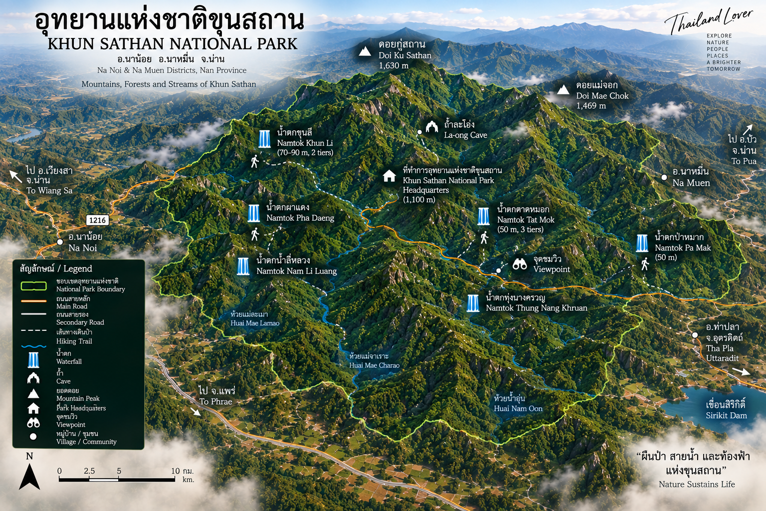
Located in the southern part of Nan, the park protects a large mountainous landscape originally surveyed from the forests on the right bank of the southern Nan River. Its terrain is rugged and steep, with mountain ranges generally extending from north to south.
The landscape rises from low valleys into high ridges, creating a succession of mountain, forest, valley, stream, waterfall and mountain again. This is what gives Khun Sathan its distinctive character. It is not a park built around one single landmark. It is a highland landscape.
A Park Between Nan and the Mountains
Khun Sathan occupies an important geographical position in southern Nan. The park lies primarily within Na Noi and Na Muen districts, while the larger mountain and watershed landscape extends toward neighbouring Tha Pla District of Uttaradit. The Nan River forms an important geographical boundary toward the Uttaradit side.
The mountains therefore form part of the larger upland system surrounding the southern Nan basin and the upper Nan River.
One of the most important geographical features is the mountain ridge of Doi Prae Mueang, which functions as a natural divide between Nan and Phrae. This is typical of northern Thailand’s mountain geography: provincial boundaries frequently follow ridges and watersheds rather than flat political lines. From the traveller’s perspective, a single mountain road can move through a landscape whose geography crosses several administrative boundaries.
The Mountains of Khun Sathan
- Doi Ku Sathan · ดอยกู่สถาน
- Approximately 1,630 metres. One of the park’s defining mountains, associated with a high viewpoint and cool mountain climate throughout much of the year. The summit area provides broad views across the surrounding landscape and is particularly atmospheric when mist fills the valleys below.
- Doi Mae Chok · ดอยแม่จอก
- Approximately 1,424–1,469 metres. One of the best-known scenic areas in Khun Sathan, characterised by cool temperatures, layered ridges, morning mist, sunrise and expansive valley views. Park headquarters and camping facilities sit in the highland landscape around Doi Mae Chok, making this one of the most accessible mountain experiences in the park.
Doi Mae Chok is not necessarily the highest mountain in the park. It is important because it is where visitors can experience the highland character of Khun Sathan most directly. You do not need to undertake a major expedition to feel the mountain climate. The road already takes you there.
Sources describing Khun Sathan give the highest elevation of the park’s mountain landscape at approximately 1,726 metres. Some older tourism references identify this high point as being associated with Doi Phu Kha. That requires an important geographical distinction: Doi Phu Kha National Park is a separate protected area, and the famous Doi Phu Kha massif extends across the broader Nan mountain region.
Do not simply label “Doi Phu Kha 1,726 m” as an attraction inside Khun Sathan. Show the highest elevation of the Khun Sathan landscape as approximately 1,726 m, and distinguish neighbouring Doi Phu Kha from Khun Sathan itself.
A Forest of Many Layers
Khun Sathan contains several forest ecosystems because of its large elevation range: mixed deciduous forest, deciduous dipterocarp forest, pine forest, hill evergreen forest and dry evergreen forest. This diversity is one of the park’s most important ecological characteristics.
- Pine forests
- The high ridges are particularly associated with pine. Both two-needle pine (Pinus merkusii) and three-needle pine (Pinus kesiya) have been documented. Tall, straight trunks rise from open forest floors. During the cool season, mist moves between the trees. The atmosphere becomes almost alpine by Thai standards — very different from the dense tropical rainforest of southern Thailand.
- Mixed deciduous forest
- More common at lower and intermediate elevations. In the rainy season, green dominates. In the dry season, the forest changes colour and many trees shed their leaves. Khun Sathan is not the same landscape in January as it is in August.
- Deciduous dipterocarp forest
- Drier ridges and slopes support this ecosystem, which is particularly vulnerable to fire during the dry season. DNP’s fire-risk assessment identifies significant areas of Khun Sathan within categories requiring fire monitoring and management.
Watershed Forest
Perhaps the most important function of Khun Sathan is its role as a source of water. Mountain streams originating in the park include waterways associated with Huai Nam Oon, Huai Nam Haeng, Huai Nam Li, Nam Sa, Nam Tha and Mae Sakhon. These streams descend from the highlands toward larger river systems.
Rain enters the forest. The soil absorbs it. Roots stabilize the slopes.
Streams gather in the valleys, and water eventually moves toward the Nan River system. The forest acts as a natural water-storage landscape.
Khun Li Waterfall
น้ำตกขุนลี
Khun Li is one of the park’s most dramatic waterfalls. It is associated with Doi Ku Sathan and has a total vertical drop of approximately 100 metres. Older national-park references describe it as a large waterfall with multiple levels, with the most beautiful section dropping approximately 25 metres.
Khun Li is not a casual roadside attraction. Traditional descriptions emphasise that access requires a difficult forest walk, including areas where leeches are common. Some sources describe approximately four hours of walking for the route.
That makes Khun Li fundamentally different from the viewpoints around Doi Mae Chok. It belongs to the wilderness side of Khun Sathan.
Tat Mok Waterfall
น้ำตกตาดหมอก
Also known as Ban San Waterfall, Tat Mok is a substantial three-tier waterfall with a total height of approximately 50 metres. It is associated with Doi Mae Chok and is located roughly 3 km from the nearby village area according to established tourism descriptions.
The three tiers create a succession of cascades rather than one uninterrupted drop. The rainy season is when Tat Mok becomes particularly impressive.
Pha Daeng and Nam Li Luang
- Pha Daeng Waterfall · น้ำตกผาแดง
- A multi-level waterfall near the La-ong Cave area. Descriptions identify several major levels, with the highest major drop approximately 15 metres. Its character is more intimate than Khun Li or Tat Mok: rock, forest, multiple levels and flowing water rather than a single enormous cascade.
- Nam Li Luang Waterfall · น้ำตกน้ำลีหลวง
- Another waterfall within the park’s network of forest attractions. Together with Khun Li, Tat Mok and Pha Daeng, it has historically been included among seasonal attractions subject to wet-season management and closure.
La-ong Cave
ถ้ำละโอ่ง
One of Khun Sathan’s most interesting geological attractions is La-ong Cave. The cave is approximately 1.8 kilometres long and contains an underground stream, stalactites, stalagmites, underground chambers and limestone formations.
This is not a decorative tourist cave with extensive infrastructure. It is a genuine natural cave environment. Access and safety conditions are highly dependent on season and water level.
The presence of a stream inside La-ong Cave is one of its defining characteristics, which makes the cave particularly sensitive to rainfall. During periods of high water, underground streams can rise rapidly. Cave access must follow official park instructions.
A cave with flowing water should never be treated like a conventional sightseeing cave.
The Scenic Road of Khun Sathan
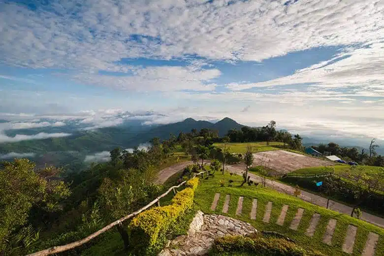
One of the park’s most underrated attractions is not a destination. It is Highway 1216. The road between Ban Khun Sathan and Ban San passes through the highland landscape and provides continuous views of mountains, forest, valleys, mist, agricultural landscapes and seasonal flowers.
The road itself becomes a scenic route — particularly attractive for travellers who enjoy driving rather than simply arriving.
The “Thai Sakura”
พญาเสือโคร่ง · Wild Himalayan cherry
During the cool season, parts of the Khun Sathan landscape can transform when wild Himalayan cherry (Prunus cerasoides) blooms. In Thailand it is popularly called Phaya Suea Krong and is often marketed as “Thailand’s sakura.” The flowers range from pale pink to deeper pink and can cover sections of the mountain landscape. This is one of the strongest seasonal reasons to visit Khun Sathan.
The flowering period varies according to temperature, rainfall, elevation and annual weather conditions. January is traditionally a strong period, while some years extend into February.
Wild Himalayan cherry usually blooms during the cool season, with January often providing a strong opportunity, but flowering varies from year to year.
Sea of Mist, Sunrise and Sunset
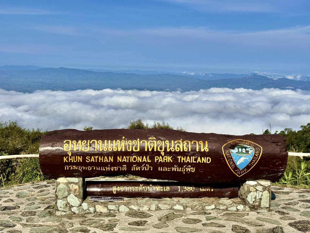
Khun Sathan’s elevation makes it one of Nan’s atmospheric mist destinations. When humid air becomes trapped in the valleys below the high ridges, the landscape can transform into a sea of clouds beneath the mountain. The best conditions often occur after rain, during cool mornings, when humidity is high and winds are light. Mist is weather-dependent. There is no guarantee on any particular morning.
Doi Mae Chok is particularly suited to sunrise photography. The combination of high elevation, an open viewpoint, layered ridges, valley mist and low-angle morning light creates a classic northern Thailand mountain scene. The attraction is not merely the sunrise. It is the changing landscape as the first light reveals the mountain layers.
At sunset, as the sun falls behind the surrounding ranges, the ridges become progressively darker. On clear days, the mountains form layers extending toward the horizon. On misty days, the landscape becomes softer and more atmospheric.
Khun Sathan at Night
This is where Khun Sathan has developed a particularly important modern identity. The park is recognised by the National Astronomical Research Institute of Thailand (NARIT) as a Dark Sky Park for the 2026–2028 registration period. High elevation and distance from major urban light sources provide relatively good night-sky conditions.
NARIT specifically identifies the area as suitable for Milky Way observation, astronomical learning, meteor-shower viewing, constellation observation, astrophotography and deep-sky observation. Under suitable conditions, visitors may observe Orion, Gemini, Cassiopeia, the North Star, Jupiter and Saturn. NARIT also highlights objects such as the Pleiades (M45) and the Orion Nebula (M42) as examples of what can be seen under appropriate conditions.
Day: mountains + mist + waterfalls + pine forest. Night: dark sky + Milky Way + constellations + silence.
For ThailandLover, this day-and-night combination is one of the park’s strongest differentiators.
Wildlife and Birdwatching
Khun Sathan’s forests provide habitat for a variety of mammals, birds, reptiles and amphibians. Reported wildlife includes sambar deer, barking deer / muntjac, wild boar, macaques, bears, Siamese hare, forest birds, frogs, freshwater fish and reptiles. Older park descriptions also mention larger and more elusive wildlife. Such species lists should be treated as reported fauna of the protected landscape, not a promise of sightings.
The park is particularly suitable for forest birdwatching because of pine, mixed deciduous and evergreen forest, elevation, streams and forest edges. Possible observations include bulbuls, drongos, barbets, woodpeckers, flycatchers, junglefowl, hill mynas and forest raptors. The best strategy is simple: start early, walk slowly and listen.
Look for signs of wildlife rather than expecting wildlife to perform for you. Tracks, calls, scratched bark, droppings, movement in the canopy — these are often more realistic encounters than a dramatic photograph of a wild animal.
The Human Landscape
Khun Sathan is not an untouched wilderness without people. Communities live around the park. The surrounding highlands include both Thai local communities and hill communities, including Hmong communities documented in the broader area. Traditional livelihoods include agriculture, forest-dependent activities, livestock, community trade and local food production.
The mountain landscape is part of a broader cultural geography connected to village life, farming, seasonal weather, water, mountain roads and traditional knowledge.
Present Khun Sathan as a protected mountain landscape that exists alongside communities whose lives remain closely connected to the surrounding forest and water — not as an empty wilderness.
The Origin of the Park
The modern conservation story began with surveys of the forests on the right bank of the southern Nan River. The area was recognised as a large and relatively important forest landscape containing valuable forest resources, wildlife habitat, mountain watersheds and scenic landscapes.
The proposal to establish the park dates back to the late 1990s, with formal preparation continuing for many years. Khun Sathan is an example of how long it can take to transform a forest landscape into a legally established national park. It was eventually declared Thailand’s 130th national park in March 2017.
Why Protection Matters
The park’s mountains contain important watershed forests. Like many northern Thai forests, Khun Sathan faces pressures including forest fire, agricultural expansion, forest clearing, illegal logging, wildlife hunting and collection of forest products.
In November 2025, DNP began a public-participation process for a proposed expansion of 13,696 rai across three areas in Ping Luang Subdistrict, Na Muen District: Ban Ping Nai, Ban Huai Yen, Ban Nam Kerm and Ban Nam Li Tai. The proposed expansion includes forest, biodiversity and watershed areas, but also communities and existing land use.
- Current legal park
- 227,921.56 rai / approximately 364.67 km²
- Proposed addition
- 13,696 rai — not yet legal park area
The 13,696 rai should only be added to the legal park area after the relevant legal and boundary processes are completed. The DNP’s 2025 expansion consultation specifically identifies illegal logging, wildlife hunting, forest encroachment, agricultural expansion, collection of forest products and forest burning — pressures that affect not only biodiversity but also the watershed function of the mountain landscape.
Seasonal Closures
Khun Sathan has historically operated under seasonal closure arrangements. DNP’s published closure schedules have included:
- 1 March – 30 June
- Closure of tourism and overnight stays across the park in the cited schedule.
- 1 July – 30 September
- Specific natural attractions including Khun Li Waterfall, Tat Li / Ta Khli, Pha Daeng Waterfall, Nam Li Luang Waterfall and La-ong Cave have been listed for seasonal closure.
Because DNP can revise annual closure dates, these historical schedules should not be presented as the definitive 2026 timetable without checking the current park announcement.
The Best Time to Visit
- November–February · the signature season
- Generally the strongest period for cool weather, mountain viewpoints, sea of mist, sunrise, camping, pine forests, wild Himalayan cherry and dark-sky experiences. This is the season when Khun Sathan looks most like the image people have in mind when they imagine the mountains of Nan.
- March–May
- The landscape becomes warmer and drier. Forest-fire and haze conditions become increasingly important. Some park areas may be closed for ecological recovery or fire management. Do not plan a trip based solely on the calendar — check the park’s current status.
- June–October
- The forest becomes intensely green. Waterfalls become more powerful. Cloud and mist can create spectacular scenery. Rain also brings slippery trails, muddy roads, cave hazards, stream crossings and temporary closures. For adventurous travellers this can be a beautiful season; for casual travellers it requires considerably more flexibility.
The Khun Sathan Road Trip
Khun Sathan works particularly well as a road-trip destination. The usual approach is Nan → Wiang Sa → Na Noi → Highway 1216 → Ban Khun Sathan → Doi Mae Chok / park headquarters. The journey gradually changes from lowland agricultural scenery to high mountain forest. That transition is one of the best parts of the experience.
Highway 1216 is more than an access road. Along it the traveller encounters mountain slopes, pine forest, villages, agricultural terraces, viewpoints, mist and seasonal flowers.
The wider landscape is also connected to the Sirikit Dam / Sirikit Reservoir toward the Uttaradit side of the upper Nan River. Tourism descriptions have long highlighted its mountain scenery and boat-based recreation. Sirikit Dam is not the central attraction inside the core Khun Sathan headquarters zone. For a ThailandLover map, it is better represented as regional context rather than as if it were located inside the park’s main visitor area.
Where to Stay
The park provides park accommodation, camping areas, visitor facilities, parking and food / welfare facilities. NARIT’s current Dark Sky listing also confirms a visitor centre, camping ground, accommodation, parking, restrooms, welfare shop and restaurant / café at the park area.
The most distinctive accommodation experience is not luxury. It is staying high in the mountains. Wake before sunrise. Step outside. Look across the valley. If the weather is right, the mountain layers disappear beneath a sea of cloud. At night, the same location transforms into a dark-sky observatory.
That day-to-night transition is one of Khun Sathan’s strongest experiences.
What Makes Khun Sathan Different?
- Doi Phu Kha
- Famous for its enormous highland landscape and distinctive botanical resources.
- Si Nan
- Famous for dramatic viewpoints such as Doi Samer Dao and Pha Chu, and the Nan River landscape.
- Khun Nan
- Famous for the high watershed mountains around Bo Kluea and Sapan.
- Khun Sathan
- Its identity is more intimate: mist + pine forest + mountain road + waterfalls + cold air + stars.
Khun Sathan is a four-season landscape. Cool season: mountains, mist, flowers and stars. Hot season: dry forest, clear mountain structures and changing colours. Rainy season: green forest, waterfalls and clouds. Night: dark sky, Milky Way and silence. That makes it unusually versatile for a relatively low-profile national park.
Who Should Visit Khun Sathan?
Perfect for
- Independent travellers
- Couples
- Photographers
- Birdwatchers
- Campers
- Stargazers
- Mountain-road enthusiasts
- Nature lovers
- Slow travellers
- Travellers exploring southern Nan
- Visitors who prefer quiet destinations
- Travellers interested in combining nature with local communities
Less suited for
- Travellers seeking luxury resorts inside the park
- Visitors who want attractions next to the car park
- Travellers unwilling to walk
- Visitors expecting guaranteed sea-of-mist conditions
- Travellers uncomfortable with mountain roads
- Visitors planning cave or waterfall trips without checking seasonal access
The ThailandLover Experience
- Come for the mist
- Wake before sunrise. Wait. The valley begins to disappear. The mountain ridges become islands. Then the first sunlight reaches the peaks.
- Stay for the forest
- Walk beneath pine trees. Listen to birds. Follow a stream. Look for signs of wildlife. Let the landscape become quiet.
- Return for the stars
- After sunset, the mountains disappear into darkness. The sky opens. And Khun Sathan becomes something completely different.
A Perfect 2-Day Escape
- Day 1 — The mountains
- Nan → Wiang Sa → Na Noi → Highway 1216 → Khun Sathan. Explore the scenic mountain road, headquarters, Doi Mae Chok, viewpoint, pine forest and camping area. Watch sunset over the mountain layers, then stay for a dark-sky experience.
- Day 2 — Forest and water
- Wake before sunrise for sea of mist. Late morning, explore an accessible waterfall or forest trail depending on current seasonal conditions. Afternoon, drive Highway 1216 through the surrounding mountain landscape and continue toward Na Noi / Nan.
A deeper 3-day itinerary
- Day 1
- Nan → Na Noi → Khun Sathan. Mountain road, sunset and camping.
- Day 2
- Khun Sathan → Doi Mae Chok → forest / waterfall. A full day in the park.
- Day 3
- Khun Sathan → Na Muen → Sirikit Reservoir landscape. Continue southward toward the Nan River and reservoir. This creates a much more coherent geographical story than treating Khun Sathan as a one-hour photo stop.
Responsible Travel
Khun Sathan is a watershed forest. That means responsible travel is not optional.
Do
- Stay on designated trails
- Follow seasonal closure notices
- Carry waste out
- Keep noise low
- Respect local communities
- Respect agricultural land
- Follow fire restrictions
- Use designated camping areas
- Check weather before hiking
- Carry appropriate hiking equipment
- Follow park staff instructions
Do not
- Collect plants
- Collect rocks or cave formations
- Feed wildlife
- Enter closed waterfalls
- Enter caves during unsafe conditions
- Light fires outside designated areas
- Leave food waste
- Use loud music in the forest
- Approach wild animals
- Assume a trail is safe because it was open on a previous visit
Frequently Asked Questions
- What is Khun Sathan National Park?
- Thailand’s 130th national park, established on 25 March 2017. Its legal area is 227,921.56 rai / approximately 364.67 km² in southern Nan, protecting pine forest, misty highlands, waterfalls, La-ong Cave and a NARIT Dark Sky Park landscape.
- Where is it?
- Primarily in Na Noi and Na Muen districts, Nan, with the mountain landscape extending toward Tha Pla, Uttaradit. The main access is Nan → Wiang Sa → Na Noi → Highway 1216.
- When is the best time to visit?
- November–February is generally the signature season for cool weather, viewpoints, sea of mist, camping, wild Himalayan cherry and dark skies. Check current park status, especially from March onward.
- Is it a Dark Sky Park?
- Yes. NARIT recognises Khun Sathan as a Dark Sky Park for the 2026–2028 registration period, suitable for Milky Way observation, meteor showers, constellations and astrophotography under appropriate conditions.
- When does the Thai sakura bloom?
- Wild Himalayan cherry usually blooms during the cool season, with January often providing a strong opportunity, but flowering varies from year to year.
- Are waterfalls and the cave always open?
- No. Historical DNP schedules have closed tourism and overnight stays from 1 March–30 June, and listed Khun Li, Tat Li / Ta Khli, Pha Daeng, Nam Li Luang and La-ong Cave for 1 July–30 September closures. Confirm the current year’s announcement.
- What is the official area?
- The legal park area is 227,921.56 rai / approximately 364.67 km². Older 285,826-rai survey figures should not be used. A 2025 proposal to add 13,696 rai is not yet part of the legal park.
Explore More of Nan
- Doi Phu Kha National Park
- Nan’s vast highland neighbour — rare flora, sea of mist and mountain roads. A separate park from Khun Sathan.
- Si Nan National Park
- Dramatic viewpoints such as Doi Samer Dao and Pha Chu, and the Nan River landscape of southern Nan.
- Khun Nan National Park
- The high watershed mountains around Bo Kluea and Sapan — another intimate Nan highland.
- Mae Charim National Park
- River-and-forest country east of Nan town, useful on a longer Nan nature itinerary.
- Lam Nam Nan National Park
- Reservoir, forest and the Nan River landscape toward Sirikit — regional context for a southbound Khun Sathan road trip.
- Nature & Parks
- More mountains, forests and protected landscapes across ThailandLover’s collection.
Location
Find Khun Sathan National Park
Na Noi and Na Muen, Nan · gateway via Highway 1216