

National Park · Nan
Khun Nan National Park
อุทยานแห่งชาติขุนน่าน
Where Mountains, Forests and Water Begin
Bo Kluea District, Nan Province · Northern Thailand
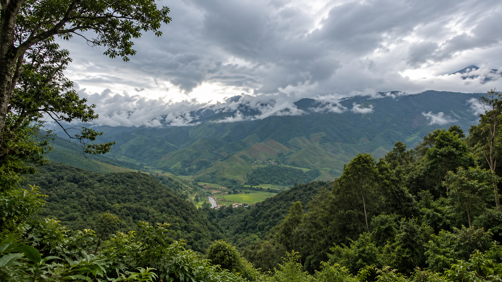
Deep in the mountains of Nan, Khun Nan protects a rugged highland landscape of forested ridges, hidden waterfalls and important watershed forests — a quieter side of Northern Thailand where the journey through the mountains is part of the destination.
A Remote Mountain Sanctuary
A remote mountain sanctuary on Nan’s high frontier — where deep forests, high ridges, year-round waterfalls and the headwaters of the Wa River shape one of the province’s most secluded landscapes.
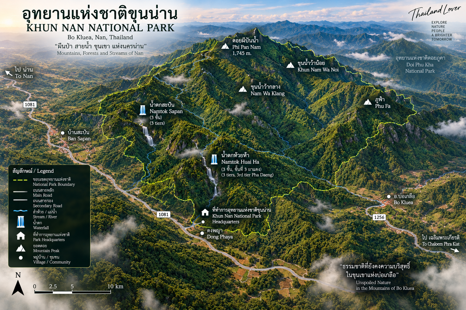
Khun Nan National Park is a mountainous protected area in Bo Kluea District, covering 153,982 rai (246.37 km²). Rising from approximately 600 to 1,745 metres, the park protects the Phu Fa, Khun Nam Wa Noi, Nam Wa Klang and Phi Pan Nam mountain systems, with Sapan Waterfall and Huai Ha Waterfall among its principal natural attractions.
Come for Sapan. Stay for the mountains. Follow the water.
Khun Nan at a Glance
- Official Name
- Khun Nan National Park
- Thai Name
- อุทยานแห่งชาติขุนน่าน
- Province
- Nan
- District
- Bo Kluea
- Subdistricts
- Phu Fa, Bo Kluea Tai, Dong Phaya
- Established
- 15 July 2009
- National Park No.
- 111th national park of Thailand
- Official Area
- 153,982 rai / 246.3712 km²
- Elevation
- Approximately 600–1,745 m above sea level
- Highest Summit
- Phi Pan Nam — 1,745 m
- Major Mountain Systems
- Phu Fa, Khun Nam Wa Noi, Nam Wa Klang, Phi Pan Nam
- Major River System
- Wa River
- Key Waterfalls
- Sapan Waterfall, Huai Ha Waterfall
- Forest Character
- Highland forest, hill evergreen forest, moist forest
- Landscape
- Steep mountain ridges, deep valleys, streams, waterfalls and watershed forest
- Gateway Area
- Bo Kluea / Sapan
- Nearby Destination
- Sapan Village and Bo Kluea salt wells
- Major Road
- Highway 1081
- Ecological Role
- High-elevation Class 1A watershed and forest habitat
The current official area is 153,982 rai, equivalent to 246.3712 km². Khun Nan was formally established on 15 July 2009 as Thailand’s 111th national park. In 2025, the Department of National Parks also began a public-participation process concerning a proposed 1,419.64-rai expansion. The existing legal park area should not be confused with that proposed addition.
The Mountain World of Khun Nan
There are places in Northern Thailand where the mountains are the destination. And then there are places where the mountains become the entire experience.
Khun Nan National Park belongs to the second category.
Located in Bo Kluea District of Nan Province, the park occupies a rugged highland landscape along the mountainous frontier of northern Thailand. Its terrain is dominated by long, interconnected ridges rather than broad valleys or open plateaus.
The terrain rises from roughly 600 metres to 1,745 metres above sea level, with the summit of Phi Pan Nam in Dong Phaya Subdistrict forming the highest point. Lower slopes are warmer and more heavily influenced by streams and moist valleys. Higher ridges become cooler, cloudier and increasingly dominated by highland forest.
The result is a landscape that feels distinctly different from the agricultural valleys of Nan.
Here, the mountains are not scenery around the road. The mountains are the road.
A Park Built Around Water
The most important story of Khun Nan is not simply its mountains. It is water.
The park is classified as an important Class 1A watershed area, with steep mountain terrain serving as a source of streams and rivers. The Wa River is one of the principal waterways associated with the landscape. Its headwaters originate in the surrounding mountains, and streams descending from the high ridges feed the river system.
Important tributaries and mountain streams include waterways associated with Nam Wa, Nam Pad, Nam Pan, Huai Ti, Huai Ha and Nam Paet. These streams cut through the mountain landscape, forming narrow valleys, cascades and waterfalls.
Forest → mountain → stream → river.
That relationship is fundamental to understanding Khun Nan. The forest is not simply something to look at. It is the infrastructure that holds the mountain together and releases water downstream.
The Four Mountain Systems
- 1. Phu Fa Range
- One of the major mountain systems within the park, strongly associated with the wider Phu Fa landscape of Bo Kluea — high ridges, forest and remote communities. The terrain is steep and heavily dissected by streams, creating the folded appearance of Nan’s northern mountains.
- 2. Khun Nam Wa Noi Range
- Another important ridge system. Its importance is primarily ecological: these mountains function as part of the watershed landscape feeding streams that eventually connect with the larger Wa River system.
- 3. Nam Wa Klang Range
- Together with the surrounding ridges, it creates a continuous mountainous environment with relatively little flat terrain. This is one reason Khun Nan feels much more like a wilderness landscape than a conventional sightseeing park.
- 4. Phi Pan Nam Range
- The range contains the highest summit in the park. The summit of Phi Pan Nam lies in Dong Phaya Subdistrict and reaches approximately 1,745 metres above sea level. The high elevation creates cooler conditions, cloud formation and a different forest environment from the lower valleys.
Khun Nan is not simply a waterfall park. It is a high-elevation watershed landscape whose waterfalls are the visible expression of a much larger mountain system.
Forests of Khun Nan
Khun Nan is primarily a forest landscape. The Department of National Parks describes significant hill evergreen and dry evergreen forest, while older ecological descriptions also identify moist forest along streams and valleys. Elevation, moisture and slope create different forest environments.
- Highland / hill evergreen forest
- At higher elevations the forest becomes cooler and more humid. Typical vegetation includes species of Castanopsis, Lithocarpus, magnolia relatives, wild laurels, ferns, mosses, orchids and climbing plants. The forest floor can remain damp and shaded, particularly during the rainy season.
- Moist forest along streams
- Along rivers and smaller mountain streams, moisture levels remain high. These areas support trees and vegetation adapted to permanently or seasonally wet conditions, together with bamboo, palms, rattan, vines and dense undergrowth — the lush environment surrounding Khun Nan’s waterfalls.
Wildlife
Khun Nan forms part of the larger forest landscape of northern Nan and remains important for wildlife. The Department of National Parks has reported evidence and sightings of species including barking deer, sambar deer, wild boar, serow, binturong, Asiatic black bear, Malayan porcupine, mouse deer, gaur, squirrels, treeshrews, junglefowl, numerous forest birds, and protected freshwater turtles in appropriate habitats.
These should be understood as reported wildlife of the protected landscape, not a guarantee that visitors will see them.
For wildlife enthusiasts, the most important attraction is therefore not a guaranteed animal encounter. It is the possibility of entering a relatively intact mountain forest where wildlife still moves through connected habitat.
The Birds of Khun Nan
The combination of elevation, evergreen forest, streams and remote mountain habitat makes Khun Nan particularly interesting for birdwatchers. Possible observations include forest bulbuls, drongos, leafbirds, barbets, woodpeckers, laughingthrushes, flycatchers, sunbirds, pheasants, junglefowl and raptors.
Higher elevations and forest edges can produce very different bird communities from the warmer lowlands. For serious birdwatchers, the park is best approached as a quiet forest-observation destination, rather than a checklist-driven attraction.
Sapan Waterfall
น้ำตกสะปัน
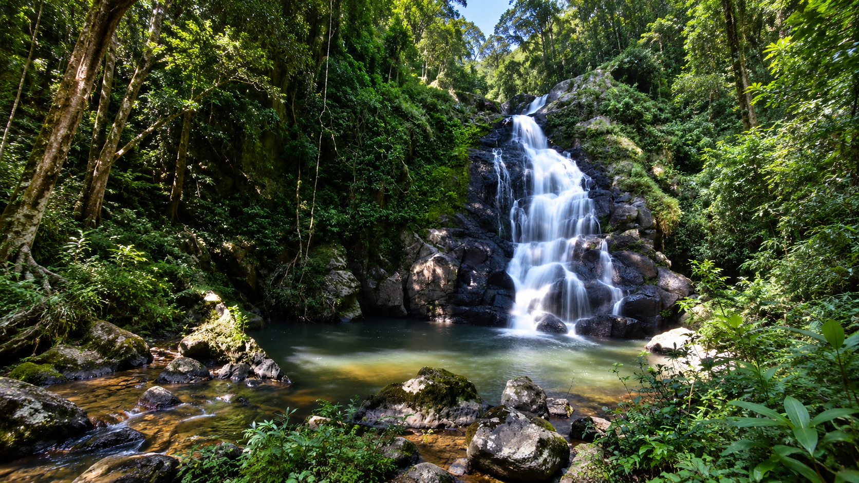
If Khun Nan has one waterfall most closely associated with the visitor experience, it is Sapan Waterfall. Located near Ban Sapan in Dong Phaya Subdistrict, it is a three-tier waterfall with water flowing throughout the year. The Tourism Authority of Thailand describes it as a medium-sized waterfall surrounded by shady, relatively intact forest.
Sapan is not a gigantic waterfall. Its appeal is different: dense forest, flowing water, moss-covered rocks, cool mountain air, surrounding ridges and proximity to Ban Sapan. That combination makes it one of the most accessible natural highlights of the park.
The official TAT description places the waterfall approximately 1 km from the park office, with access from Highway 1081 followed by a short approach on foot. Road-and-walking measurements vary between sources depending on the point from which distance is measured, so it is better to think of Sapan as a short-access waterfall near the park headquarters and Ban Sapan, rather than rely on one single road-distance figure.
Huai Ha Waterfall
น้ำตกห้วยห้า
The second major waterfall experience is Huai Ha Waterfall, located in the Ban Na Bong area of Bo Kluea Tai Subdistrict. It is a three-tier waterfall with significantly larger vertical drops than Sapan.
- Level 1
- Approximately 8 m
- Level 2
- Approximately 12 m
- Level 3 — Pha Daeng
- Approximately 50 m
The third level, known as Pha Daeng, is particularly distinctive because the water descends over a series of stepped rock formations rather than falling as one perfectly vertical curtain. At approximately 50 metres, it is the dominant feature of the waterfall system. Water flows throughout the year, although the character and volume naturally change with rainfall. During the rainy season, this section becomes especially dramatic.
This is one of the strongest waterfall landscapes in Khun Nan.
Other Waterfalls
Khun Nan contains other smaller waterfalls and stream cascades, including references to Huai Ti Waterfall, Ban Den Waterfall and smaller unnamed cascades along mountain streams. These are less developed as mainstream tourism attractions than Sapan and Huai Ha.
That is part of the character of Khun Nan. Not every beautiful place has been turned into a major tourist facility.
Sapan Village
บ้านสะปัน
Although Ban Sapan is not the same thing as Khun Nan National Park, the village is one of the most important gateways to understanding the area. Sapan sits within a dramatic mountain valley surrounded by forested ridges, streams and agricultural land.
The village has become one of Nan’s best-known slow-travel destinations, particularly for mountain scenery, mist, homestays, cafés, local food, streams, rice fields, small-scale accommodation, photography and nature-based travel. The Tourism Authority of Thailand also identifies Sapan Village and Sapan Waterfall as key stops on the Nan mountain route.
Sapan Village ≠ Khun Nan National Park.
The village is a nearby community and gateway, while the national park protects the surrounding mountain and forest landscape. This distinction matters when describing the destination accurately.
Bo Kluea — The Salt-Well Country
Khun Nan is closely connected geographically and culturally with Bo Kluea, one of Nan’s most distinctive mountain districts. The name Bo Kluea literally relates to salt wells. Traditional salt production in the district uses naturally occurring saline groundwater brought to the surface and evaporated to produce salt.
This creates an unusual combination: high mountain forest + ancient salt-making tradition + remote communities. The result is one of the most distinctive cultural landscapes in northern Thailand.
For a ThailandLover itinerary, Khun Nan works especially well when combined with Nan → Pua → Doi Phu Kha → Bo Kluea → Khun Nan → Sapan, rather than treated as an isolated day-trip destination.
Highway 1081 and the Wider Mountain Roads
One of the most important access roads in the region is Highway 1081. It connects the mountain communities around Bo Kluea and provides access toward the Khun Nan / Sapan area. This is not simply a transportation route. The road itself has become part of the Nan mountain-road experience.
The landscape changes continuously: forest → ridge → valley → village → mountain stream → forest again. The road connects Khun Nan with the broader mountain tourism circuit of northern Nan.
Highway 1256 is another famous mountain road in Nan, particularly the route between Pua and Doi Phu Kha. It should be treated as regional context, not automatically described as a road inside Khun Nan National Park. That distinction is important because Khun Nan sits within a much larger network of protected forests and mountain destinations.
Geology & Landscape
Khun Nan is fundamentally a mountain and watershed landscape. The terrain consists of interconnected ridges and deeply dissected valleys, producing steep slopes and narrow drainage systems.
Rather than the dramatic limestone karst seen in places such as Khao Sok or Khao Sam Roi Yot, Khun Nan’s visual identity comes from folded mountain ridges, forest-covered slopes, weathered rock, stream valleys, steep escarpments, high-elevation ridges, mist and cloud.
This is a landscape shaped by water and elevation. Rain falls on the high ridges. Forest holds the soil. Streams gather in the valleys. And the mountain water eventually becomes part of larger river systems.
The Climate of Khun Nan
Khun Nan’s elevation creates a noticeably cooler mountain climate than Nan’s lowland areas. Weather should take priority over an itinerary.
- Cool season · November–February
- Generally the most comfortable period for mountain travel. Higher elevations can become distinctly cold, particularly before sunrise. Morning mist is common under suitable weather conditions.
- Hot season · March–May
- Lower elevations become warmer, while higher ridges remain comparatively cool. This is also an important period for monitoring forest-fire and haze conditions in northern Thailand.
- Rainy season · May–October
- The forest becomes intensely green. Streams and waterfalls become more powerful, and mountain mist becomes a major part of the landscape. For photographers, the rainy season can produce the most atmospheric version of Khun Nan. Wet-season travel also means slippery trails, rapidly rising streams, reduced visibility, wet roads and possible local access restrictions.
Why Khun Nan Looks Different from Doi Phu Kha
Khun Nan and Doi Phu Kha National Park are geographically close and form part of the same broader mountain environment. But they offer different experiences.
| Doi Phu Kha | Khun Nan | |
|---|---|---|
| Character | Large-scale mountain scenery, high-elevation landscapes, major viewpoints, famous mountain roads, extensive park tourism | More intimate and remote — watershed forest, waterfalls, high mountain valleys, Sapan, quiet forest, smaller-scale nature experiences |
| Together | One of the most compelling mountain regions in Nan | |
Khun Nan & the Greater Forest Landscape
One of Khun Nan’s most important characteristics is that it should not be viewed as an isolated green island. The park lies within a broader network of protected and reserved forest in northern Nan.
The Department of National Parks has specifically highlighted the ecological connection between Khun Nan and surrounding forest areas, noting that these connected habitats provide important food and movement areas for wildlife. This connectivity is especially important for large mammals and species requiring substantial forest territory.
For conservation, connectivity can be more important than the size of any single protected area.
The 2025 Expansion Proposal
In December 2025, the Department of National Parks opened a public participation process concerning a proposed expansion of Khun Nan National Park. The proposed additional area covered 1,419.64 rai, divided into 1,404.06 rai associated with the national park headquarters area in Bo Kluea Tai and Dong Phaya, and 15.58 rai associated with the proposed incorporation of the Na Khwang protection unit area. The process was subject to public participation and boundary verification.
The proposed expansion must not be added to the current legal park area unless and until the relevant legal process is completed.
Current legal park area: 153,982 rai / 246.3712 km².
That is the figure ThailandLover uses for the park itself. The 125,000-rai / ~200 km² figure should not be used as the current official park area. The Department of National Parks’ 2025 publication gives the current official figure as 153,982 rai / 246.3712 km².
What Makes Khun Nan Special?
Khun Nan is not Thailand’s biggest national park. It does not have the country’s tallest waterfall. It does not have the most famous summit. It does not compete with Khao Yai or Khao Sok in visitor numbers.
And that is precisely its value.
Khun Nan is about scale and atmosphere. It is a place where mountains remain dominant, forests remain continuous, water still comes from the forest, villages remain embedded in the landscape, and travel still feels slower.
The ThailandLover Experience
- Come for the waterfalls
- Sapan is the accessible introduction. Huai Ha is the deeper waterfall experience.
- Stay for the mountains
- The real attraction is the landscape surrounding them.
- Watch the weather
- Mist is part of the experience, not an inconvenience.
- Slow down
- Khun Nan rewards travellers who stop trying to collect attractions. A road through the mountains can be as memorable as a destination.
Best Experiences
- 01 — Sapan Waterfall
- A short nature experience surrounded by forest and flowing water. Best for first-time visitors, photography, families and slow travel.
- 02 — Huai Ha Waterfall
- A larger and more dramatic three-tier waterfall, culminating at the approximately 50-metre Pha Daeng tier. Best for nature lovers, waterfall photography and deeper forest experiences.
- 03 — Mountain roads
- Drive slowly through the highlands around Bo Kluea and Khun Nan. Best for road trips, landscape photography and mountain scenery.
- 04 — Sapan Village
- Combine the national park experience with community-based mountain travel. Best for cafés, homestays, local food, mist and slow travel.
- 05 — Bo Kluea
- Experience one of Nan’s most distinctive cultural landscapes through its traditional salt-producing communities. Best for culture + nature itineraries.
- 06 — Highland forest
- Look beyond the famous attractions. The forest itself is the destination. Best for birdwatching, wildlife observation, hiking and solitude.
Who Should Visit Khun Nan?
Perfect for
- Independent travellers
- Nature lovers
- Landscape photographers
- Birdwatchers
- Slow travellers
- Mountain-road enthusiasts
- Couples and small groups
- Travellers staying around Sapan
- Travellers exploring Nan by car or motorcycle
- Visitors looking for quieter national parks
Less suited for
- Travellers looking for large entertainment complexes
- Luxury-resort style holidays
- Visitors expecting extensive urban facilities
- Travellers who want attractions concentrated within a few hundred metres
- Visitors uncomfortable with mountain roads
Responsible Travel
Khun Nan is a watershed forest. That makes responsible travel particularly important.
Do
- Stay on designated trails
- Carry waste out of the forest
- Keep noise low
- Respect wildlife and avoid feeding animals
- Follow park instructions
- Use authorised camping areas
- Support local communities responsibly
- Respect local agricultural and cultural areas
- Check weather conditions before entering remote areas
Do not
- Collect plants, rocks or wildlife
- Enter closed areas
- Approach wild animals
- Use drones where prohibited
- Light unauthorised fires
- Leave food waste behind
- Treat streams and waterfalls as personal swimming pools when conditions are unsafe
The forest is not scenery. It is the watershed.
A Perfect Nan Mountain Route
4 days / 3 nights — nature, national park, mountain roads, community and culture, rather than rushing through every attraction.
- Day 1
- Nan → Pua → Doi Phu Kha. Explore the northern mountain landscape and continue toward Bo Kluea.
- Day 2
- Bo Kluea → Khun Nan → Sapan. Visit Bo Kluea, Khun Nan National Park, Sapan Waterfall and Sapan Village. Stay around Sapan.
- Day 3
- Sapan → mountain roads → Huai Ha / surrounding highlands. A slower day for mountain scenery, forest and waterfalls.
- Day 4
- Sapan → Nan. Return through Nan’s mountain-road landscape.
Frequently Asked Questions
- What is Khun Nan National Park?
- Thailand’s 111th national park, established on 15 July 2009. It covers 153,982 rai / 246.3712 km² in Bo Kluea District, Nan, protecting highland forest, Phi Pan Nam at 1,745 metres, and year-round waterfalls including Sapan and Huai Ha.
- Where is it?
- Bo Kluea District, Nan Province, across Phu Fa, Bo Kluea Tai and Dong Phaya subdistricts. The usual gateway is the Bo Kluea / Sapan area via Highway 1081.
- What is the official area?
- The current legal park area is 153,982 rai / 246.3712 km². Older figures around 125,000 rai should not be used. A 2025 proposal to add 1,419.64 rai is not yet part of the legal park area.
- What are the main waterfalls?
- Sapan Waterfall, a three-tier cascade near Ban Sapan and the park office, is the most accessible. Huai Ha Waterfall, in Bo Kluea Tai, is a larger three-tier system whose third level, Pha Daeng, drops about 50 metres.
- Is Sapan Village part of the park?
- No. Ban Sapan is a nearby mountain community and gateway. The national park protects the surrounding mountain and forest landscape.
- How is it different from Doi Phu Kha?
- Doi Phu Kha is known for large-scale mountain scenery, major viewpoints and famous roads. Khun Nan feels more intimate and remote, with watershed forest, waterfalls, high mountain valleys and quieter nature around Sapan and Bo Kluea.
- When is the best time to visit?
- November–February is generally the most comfortable cool season, with morning mist common. March–May is hotter at lower elevations, with haze and fire risk to watch. May–October brings greener forest and stronger waterfalls, but also slippery trails and wet mountain roads.
Nearby Destinations
- Doi Phu Kha National Park
- Nan’s vast highland neighbour — rare flora, sea of mist, mountain roads and the natural counterpart to Khun Nan’s quieter valleys.
- Si Nan National Park
- Another Nan mountain and forest landscape for travellers continuing through the province.
- Mae Charim National Park
- River-and-forest country east of Nan town, useful on a longer Nan nature itinerary.
- Nanthaburi National Park
- A further Nan protected landscape for travellers exploring the province beyond Bo Kluea.
- Lam Nam Nan National Park
- Reservoir, forest and the Nan River landscape — a different water story from Khun Nan’s highland headwaters.
- Northern Thailand national parks
- More mountains, forests and protected landscapes across ThailandLover’s Nature & Parks collection.
Location
Find Khun Nan National Park
Bo Kluea District, Nan · gateway via Highway 1081 and Ban Sapan