

National Park · Chiang Mai · Preparatory Area
Namtok Bua Thong–Nam Phu Chet Si National Park
Where Groundwater Becomes a Waterfall
Mae Ho Phra · Mae Taeng · Chiang Mai
A remarkable limestone landscape in northern Chiang Mai, where a natural spring, mineral-rich water and forest combine to create Thailand’s famous Sticky Waterfall.
Bua Thong Waterfall & the Seven-Colored Spring
Where groundwater emerges from the mountains and slowly builds a waterfall
There are waterfalls that impress because of their height. There are waterfalls that impress because of their volume. And then there is Bua Thong.
Here, the most remarkable thing is not simply the water. It is the relationship between groundwater, minerals, limestone, forest and time.
Deep beneath the surrounding mountains, groundwater moves through fractures in the rock. Eventually it emerges naturally at Nam Phu Chet Si — the Seven-Colored Spring. From there the water continues downstream, crosses the forest, reaches limestone terraces, and over time mineral deposits help create the unusual pale, textured surface of Bua Thong Waterfall.
The result is one of Chiang Mai’s most distinctive natural landscapes — famous among visitors as the Sticky Waterfall. But the nickname only tells half the story. The more interesting story is beneath your feet.
Not a hidden gem. A natural phenomenon worth understanding.
At a Glance
- Official name
- Namtok Bua Thong–Nam Phu Chet Si National Park
- Common reference
- Bua Thong Waterfall / Sticky Waterfall
- Location
- Mae Ho Phra, Mae Taeng, Chiang Mai
- Current status
- Preparatory / proposed national park
- Surveyed area
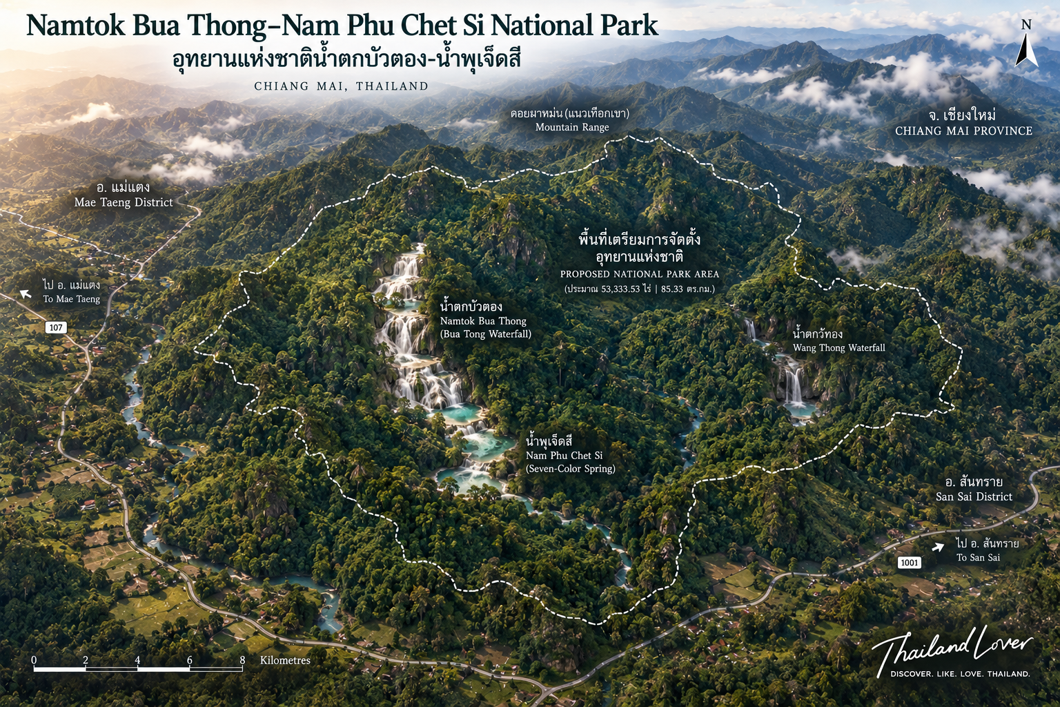
- Approx. 53,333.53 rai / 85.33 km²
- Elevation
- Approx. 350–947 m within the surveyed area
- Landscape
- Mountain ranges, valleys, streams, forest and limestone
- Key geology
- Groundwater and carbonate-rich spring water
- Main attractions
- Nam Phu Chet Si · Bua Thong Waterfall · Wang Thong Waterfall
- Signature experience
- Walking designated limestone sections of the waterfall
DNP describes the preparation area as a mountainous landscape of ridges, valleys and streams, extending generally north to south. It lies along the Mae Pon fault zone, which contributes to fractures through which groundwater can move and emerge as natural springs.
First, Understand the Name
Bua Thong and Nam Phu Chet Si
The name describes two closely connected natural features. Nam Phu Chet Si is the natural spring. Bua Thong Waterfall is where that water continues downstream across a limestone landscape.
These are not two unrelated attractions placed next to each other. They are part of one natural system:
Groundwater → Spring → Stream → Limestone → Waterfall
That sequence is the real story of Bua Thong.
The Landscape
Mountains, Valleys and Water
The landscape is dominated by mountain ranges separated by valleys and streams. The surveyed area ranges from approximately 350 to 947 metres above sea level. Terrain is strongly influenced by geological structure and by the network of streams draining from the surrounding mountains.
At first glance, visitors see a forested mountain landscape. Look more closely, and the real story becomes visible: water is moving through the landscape at several levels — held within the forest, moving through soil and rock, travelling underground, and eventually emerging as springs and streams.
Bua Thong is the visible expression of this hidden water system.
The Hidden Water System
Where Does the Water Come From?
The most important question at Bua Thong is surprisingly simple: where does all this water come from? The answer begins underground.
The area lies along the Mae Pon fault zone. Fractures associated with the geological structure allow groundwater to move through the subsurface. Eventually groundwater emerges naturally at springs — one of the most important being Nam Phu Chet Si. The spring then feeds a surface stream that continues through the forest and reaches Bua Thong Waterfall.
The waterfall begins underground.
Nam Phu Chet Si
The Seven-Colored Spring
Nam Phu Chet Si is a natural cold spring that provides water to the surrounding forest throughout the year. DNP describes a forested recharge area of approximately five rai near the spring. Water emerges from the underground system, flows along the natural channel and continues toward Bua Thong Waterfall.
Older geological documentation describes the spring basin as approximately 6 × 8 metres, with water continuously emerging from underground. Exact dimensions should not be treated as the defining feature. What matters scientifically is the process:
Groundwater emerges → minerals travel with the water → light interacts with water and mineral-rich surfaces → the spring appears to sparkle
Why “Seven-Colored”?
Light, Water and Minerals
The name Nam Phu Chet Si literally means “Seven-Colored Spring.” It refers to the way the spring can appear to sparkle with different tones when sunlight interacts with the water.
DNP explains that groundwater passes through sedimentary and metamorphic rock and acquires dissolved minerals, particularly calcium and silica. The resulting water and mineral-rich surfaces can reflect and scatter light, producing the characteristic sparkling appearance.
Do not interpret “seven-colored” as meaning the water permanently contains seven fixed colors. The visual effect depends on sunlight, viewing angle, water movement, surface conditions, mineral deposits and weather. The name is best understood as a description of the spring’s shimmering visual character.
The Geological Story
Water Creates the Landscape
Bua Thong is an unusually accessible place to understand how water can shape rock. Groundwater moves through fractures. Minerals dissolve into the water. Water emerges at the surface, flows downstream, encounters limestone, and over long periods mineral deposits accumulate. The landscape changes. The waterfall develops.
Geology + Groundwater + Minerals + Forest + Time
Bua Thong Waterfall
The Sticky Waterfall
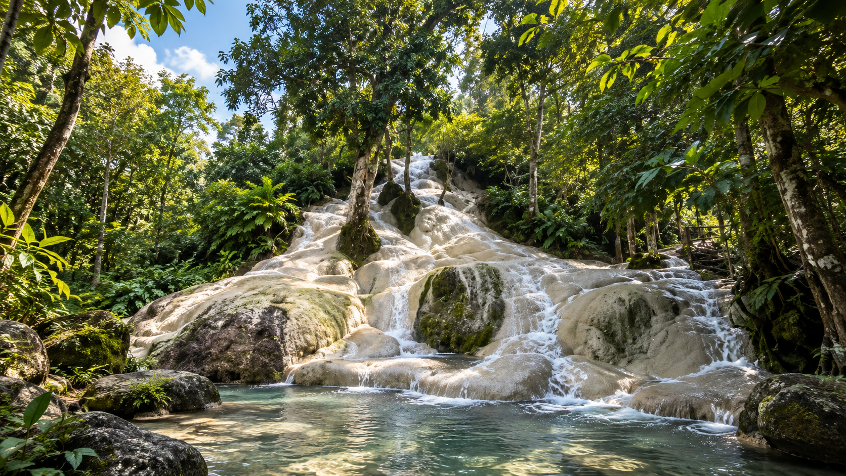
Bua Thong is a multi-tiered limestone waterfall. DNP describes it as having four tiers, with a combined length of approximately 280 metres, and reports that water flows throughout the year.
The waterfall’s pale limestone surface is its most distinctive visual feature. Instead of smooth, dark rock, visitors encounter a textured, mineral-rich surface with a light cream-to-white appearance. Unlike many waterfalls, parts of that limestone surface provide unusually good grip — which is why visitors began calling it the Sticky Waterfall.
Why Is the Waterfall “Sticky”?
Surface Texture — Not Magic
The nickname can be misleading if taken too literally. The rock is not literally sticky. Unusual grip comes from the texture and mineral character of the limestone surface, combined with the way water flows across it. Mineral deposition contributes to the rough, textured surface that allows visitors to walk or climb along designated sections more easily than they might expect.
But there is an important distinction: good grip does not mean zero risk. Wet surfaces can still be slippery. Algae or organic growth can alter traction. Fast-moving water can destabilize a person. Some areas may be unsuitable or restricted.
Experience it as a natural environment — not as an artificial climbing wall.
Four Tiers of Limestone
A Natural Staircase
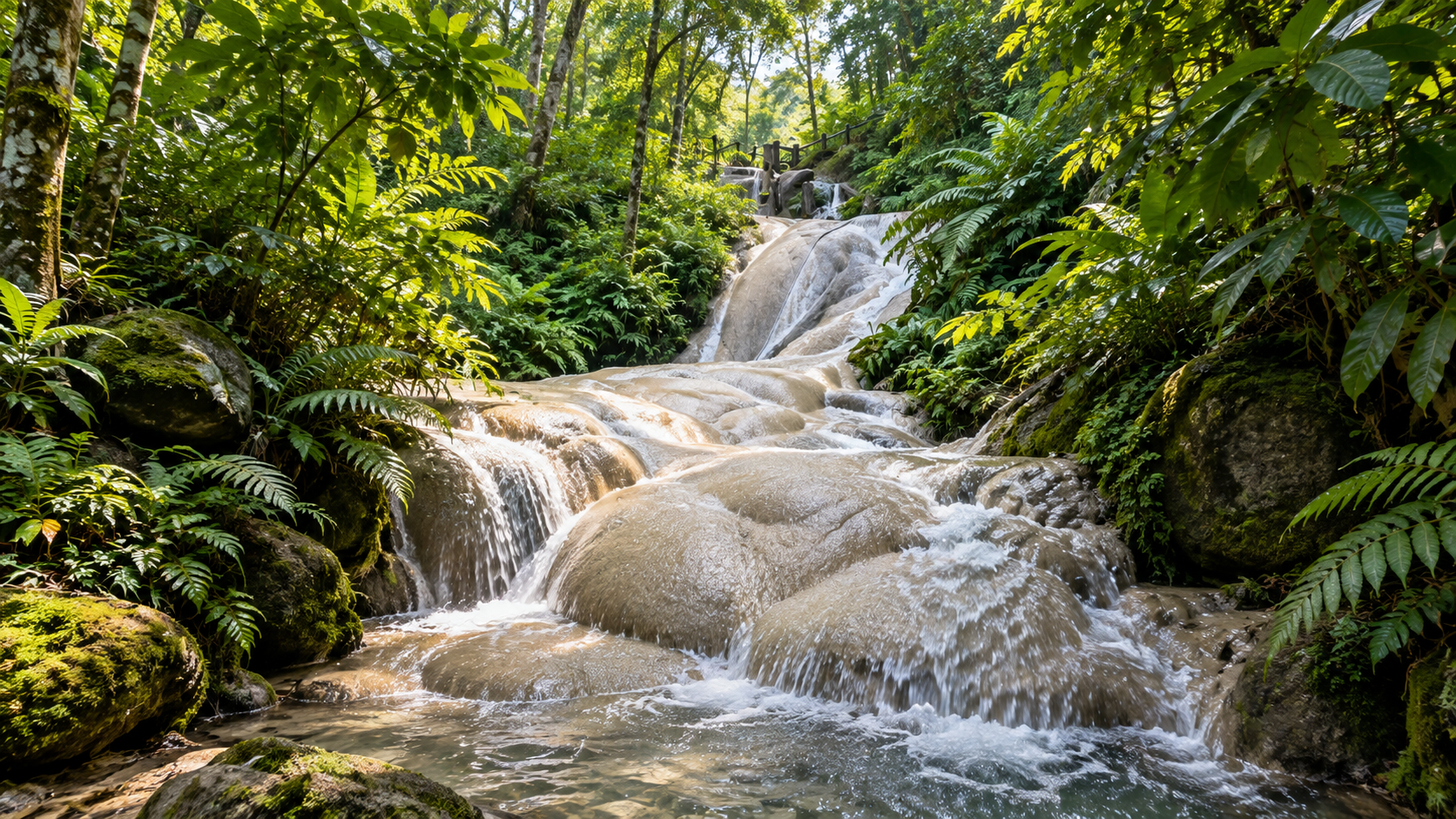
Bua Thong is not simply a vertical drop. The waterfall descends through a series of limestone terraces. Water moves across one level, drops, spreads, flows across another mineral surface — and the process continues.
Seen from below, the result resembles a natural staircase carved into the mountain. Seen geologically, it is something more interesting: a landscape being shaped by water.
Follow the Water
The Stream Between Spring and Waterfall
One of the best ways to understand Bua Thong is simply to follow the water. Begin at Nam Phu Chet Si. Watch the water leave the spring, move through the forest, follow the natural channel, and eventually reach Bua Thong Waterfall.
That journey connects what appears to be two separate attractions into one ecological and geological story.
Wang Thong Waterfall
Another Waterfall in the Same Landscape
Bua Thong is not the only waterfall here. Wang Thong Waterfall lies to the east and is another natural feature within the surrounding landscape. DNP describes it as a scenic waterfall with pools suitable for water recreation in designated areas.
It is best understood as part of the wider water landscape rather than simply a second attraction to check off a list.
The Forest
The Green Framework Around the Water
The waterfall would not exist in isolation. The surrounding forest helps maintain the water system that makes the destination possible. The preparation area includes moist evergreen forest and mixed deciduous forest.
The forest contributes to water retention, soil stability, groundwater recharge, stream flow, wildlife habitat and local climate regulation. The trees surrounding Bua Thong are not merely scenic background — they are part of the infrastructure of the ecosystem.
A Watershed Landscape
The Forest Behind the Waterfall
DNP identifies the area as an important watershed landscape. Natural springs emerging from the mountains feed streams that eventually drain toward the Ping River system.
The water in front of you is not simply “waterfall water.” It is part of a larger watershed. Protecting the forest helps protect the water — and protecting the water helps preserve the waterfall.
Wildlife and Biodiversity
Look Beyond the Water
The most visible feature of the area is water. The most important ecological feature is the forest. Rather than publishing a long list of animal species without reliable current survey data, ThailandLover emphasises the ecological relationship:
Forest → Water → Habitat → Biodiversity
That is more accurate and more useful to international readers than turning the park into a catalogue of species.
A Geological Classroom
Nature You Can Touch — Carefully
Bua Thong is unusually valuable as an educational landscape because the geological process is visible at human scale. You can see the spring, the stream, the limestone, mineral deposits, water flow, terraced rock, forest and the resulting waterfall.
A child can ask where the water comes from. A photographer can ask why the rock is white. A geology student can ask how groundwater interacts with rock. A traveller can simply ask how this place became what it is. All four questions lead to the same landscape.
What to Experience
- 01 — Nam Phu Chet Si
- Start with the spring. Observe water emerging from the ground. Watch how sunlight interacts with the surface. Then follow the stream downstream — context for everything that follows.
- 02 — Walk the Limestone Waterfall
- The signature experience is walking designated sections of Bua Thong. Move slowly, test your footing, use designated areas, and do not climb beyond your ability.
- 03 — Explore the Forest
- Look away from the water: trees, moss, ferns, rock surfaces, small streams, insects, birds and changes in moisture. The forest makes the waterfall possible.
- 04 — Photography
- Landscape shots for waterfall and forest together; detail shots of limestone texture; human scale for terrace size; close-ups of water on pale rock for almost monochrome compositions.
Best Time to Visit
A Year-Round Water Landscape
Unlike seasonal waterfalls that depend heavily on monsoon rainfall, Bua Thong is fed by a spring system that flows throughout the year. DNP states that both the Seven-Colored Spring and Bua Thong Waterfall have year-round water flow. The destination is unusually reliable — but the best season depends on what you want.
- Cool season — Nov to Feb
- Comfortable for walking, nature exploration, photography, family outings and combining Bua Thong with other northern Chiang Mai destinations. The main advantage is comfort rather than a dramatic seasonal transformation.
- Hot season — Mar to May
- Excellent for cool spring water, forest shade and outdoor recreation. Visit earlier in the day to avoid the strongest afternoon heat.
- Rainy season — Jun to Oct
- Deeper green forest — and greater safety importance. Conditions can change quickly; wet surfaces behave differently; water levels may rise. Follow park instructions and temporary closures.
- Time of day
- Morning: cooler temperatures, softer light, fewer visitors, better photography. Afternoon: suitable for water recreation and family visits, but numbers can rise sharply on weekends and holidays.
Getting There
From Chiang Mai
Bua Thong is in Mae Taeng District, north of Chiang Mai city. The principal approach follows the Chiang Mai–Phrao road. Historical geological documentation identifies the access point around kilometres 48–49, followed by approximately 2.6 kilometres of road toward the Bua Thong and Seven-Colored Spring area.
For modern travellers, use navigation apps with the destination name Bua Thong Waterfall & Chet Si Spring. Always check road conditions and access arrangements before departure.
From Chiang Mai Old City, Bua Thong works particularly well as a half-day nature escape or a full-day northern Chiang Mai excursion. You do not need a multi-hour mountain trek to experience a distinctive geological landscape — and that accessibility is part of what makes Bua Thong important.
How Long Should You Stay?
- Half day
- Enough for Nam Phu Chet Si, Bua Thong Waterfall, walking the main waterfall, photography and water recreation.
- Full day
- Time to explore the forest, photograph geological details, visit nearby attractions, eat locally and avoid a rushed schedule.
The destination is easy to see quickly. It is better understood slowly.
Visitor Numbers
Not a Hidden Gem Anymore
ThailandLover avoids calling Bua Thong a “hidden gem.” It is no longer hidden. In fiscal year 2025, DNP reported approximately 605,000 visitors, placing Namtok Bua Thong–Nam Phu Chet Si among Thailand’s five most visited national-park destinations that year.
It has also become particularly popular with international travellers. In November 2025, DNP reported more than 2,500 international visitors during the period following Chiang Mai’s Yi Peng celebrations.
Weekend + public holiday + high season = expect crowds. Arrive early for the most peaceful experience.
Safety
Sticky Does Not Mean Risk-Free
The nickname is fun. The safety issue is serious. Limestone can provide excellent grip in many areas, but it can still become slippery depending on water flow, algae, organic growth, rain, surface conditions, footwear and individual balance.
Never assume every part of the waterfall is safe to climb. Follow signs → barriers → staff instructions → your own judgment — in that order.
Water safety
Natural water is unpredictable. Even when a stream looks calm, conditions can change after rainfall upstream. Do not enter closed areas, climb beside strong currents, stand underneath unstable rock, or encourage children beyond designated areas. Never put a photograph ahead of safety.
Swimming
Water recreation is part of the appeal — but not every section should be treated as a swimming area. Use only designated areas. Conditions, water quality and flow can vary, and temporary restrictions may apply. Always follow current instructions from park personnel.
Responsible Travel
Protect the Water You Came to See
The most important thing a visitor can do at Bua Thong is simple: keep the water clean.
Do
- Take your rubbish with you and use designated waste facilities
- Follow staff instructions and stay within permitted areas
- Respect other visitors and keep noise under control
- Protect the forest and leave natural materials where they are
Don’t
- Throw rubbish into the stream or use soap/chemicals in the water
- Remove limestone, break rocks or collect plants
- Feed wildlife, damage trees or enter closed areas
- Climb restricted sections
The limestone beneath your feet is not a souvenir. It is part of the geological process that created the waterfall.
Tourism and Conservation
Popularity Has a Cost
Bua Thong demonstrates an important challenge in modern nature tourism. The same feature that makes the destination attractive also makes it vulnerable. More visitors mean more waste, more pressure on infrastructure, more erosion, more disturbance and greater safety requirements.
DNP has highlighted visitor safety and waste management at the destination, while promoting tourism that also benefits surrounding communities. The goal should not be to keep increasing visitor numbers indefinitely.
Better experiences with lower environmental impact.
What Makes Bua Thong Different?
Five Things You Can Understand Here
- 01 — Groundwater
- Water emerges naturally from underground.
- 02 — Minerals
- Dissolved minerals travel through the geological system.
- 03 — Limestone
- Mineral deposition shapes the distinctive waterfall surface.
- 04 — Forest
- The surrounding ecosystem helps sustain the watershed.
- 05 — Time
- The landscape results from processes far beyond the human timescale.
Bua Thong Is Not Just a Waterfall
It Is a Process
A conventional travel article says: “Bua Thong is a beautiful waterfall where you can climb the rocks.” That is true — and incomplete.
A better explanation: Bua Thong is a limestone waterfall fed by a natural spring system, where groundwater, minerals, forest and geological time combine to create a landscape that visitors can experience at close range.
That is the story worth telling.
Who Is Bua Thong For?
- Families
- Accessible environment for children to experience water and geology at close range — with careful supervision.
- Nature lovers
- Forest, spring, stream and waterfall together make more than a conventional sightseeing stop.
- Photographers
- Pale limestone, clear water and dense green forest offer a distinctive visual palette.
- Geology enthusiasts
- Few destinations make the relationship between water and limestone so immediately visible.
- International travellers
- Strong visual identity and an experience hard to replicate elsewhere in Chiang Mai.
- Slow travellers
- Rewards people who observe rather than only photograph.
It may be less suitable for travellers seeking remote wilderness, multi-day trekking, high-altitude mountains, complete solitude, large-scale adventure activities or luxury nature facilities. Its strength is different: accessibility + geology + water + forest.
A Better Way to Experience Bua Thong
Follow the Water
- Start at Nam Phu Chet Si
- Watch the spring emerge from the ground
- Follow the water downstream
- Observe the forest around the stream
- Reach Bua Thong Waterfall
- Look at the limestone surface
- Notice how water moves across the rock
- Only then walk the designated sections of the waterfall
From “I visited a waterfall” to “I understood where the waterfall came from.”
Why We Like It
ThailandLover does not need to call Bua Thong an undiscovered destination. It is popular. It can be crowded. It has become one of Chiang Mai’s best-known nature attractions. Popularity does not make a place less interesting — sometimes it simply means a remarkable landscape has become accessible to more people.
The important question is how we experience it. At Bua Thong, we prefer to look beyond the nickname — not just Sticky Waterfall, but:
Groundwater. Minerals. Limestone. Forest. Water. Time.
Essential Information
- Destination
- Namtok Bua Thong–Nam Phu Chet Si National Park
- Common name
- Bua Thong Waterfall / Sticky Waterfall
- Province
- Chiang Mai
- District / Subdistrict
- Mae Taeng / Mae Ho Phra
- Status
- National park preparatory area
- Surveyed area
- ~53,333.53 rai / 85.33 km²
- Elevation
- ~350–947 m
- Primary spring
- Nam Phu Chet Si
- Primary waterfall
- Bua Thong — four tiers, ~280 m (DNP survey)
- Water flow
- Year-round (DNP)
- Other waterfall
- Wang Thong Waterfall
- Best for
- Nature, geology, photography, families, water recreation, accessible outdoor experiences
Practical Notes
Before You Go
Operating hours, access arrangements, safety restrictions and visitor facilities can change — especially during heavy rainfall, flood conditions, storms, high visitor periods, maintenance and temporary conservation closures.
Check current information with the responsible park authorities before departure. Do not rely on an old travel blog for current access rules.
Final Thought
Follow the Water
Do not begin with the waterfall. Begin with the spring. Look at water emerging from the earth. Follow it. Watch it move through the forest. See it cross the limestone. And eventually, watch it become a waterfall.
What looks like a simple attraction is actually a story of water beneath the earth, forest above the ground, minerals carried by the stream, and limestone shaped by time — with people standing at the point where all four meet.
Water beneath the earth. Forest above the ground. A waterfall in between.
Leave the Landscape Intact
The best souvenir from Bua Thong is a photograph. Leave everything else where you found it.
Take nothing. Leave nothing. Disturb nothing.
Keep the water clean. Respect the forest. Follow the rules. Stay on permitted routes. Listen to local staff. Remember: the limestone you are standing on took far longer to form than your visit will last. Protect it for the next generation.
Frequently Asked Questions
- Is it a fully established national park?
- Not fully. DNP still identifies it as a preparatory / proposed national park area. ThailandLover uses the familiar name while stating that status clearly.
- Where is Bua Thong Waterfall?
- Mae Ho Phra Subdistrict, Mae Taeng District, Chiang Mai — north of Chiang Mai city along the Chiang Mai–Phrao road corridor.
- Why is it called the Sticky Waterfall?
- The pale limestone surface has an unusually textured mineral character that can provide better grip than many wet rocks. It is not literally sticky, and wet or algae-covered sections can still be slippery.
- What is Nam Phu Chet Si?
- The Seven-Colored Spring — a natural cold spring where groundwater emerges year-round, feeding the stream that becomes Bua Thong Waterfall.
- How long is the waterfall?
- DNP’s 2022 survey describes a four-tier limestone waterfall extending approximately 280 metres in total. Older references sometimes cite about 100 metres for a partial measurement.
- Does water flow year-round?
- Yes. DNP states that both the Seven-Colored Spring and Bua Thong Waterfall have year-round flow because the system is spring-fed.
- When is the best time to visit?
- Any season can work. Cool season is most comfortable; hot season suits cool water and shade; rainy season is greener but needs extra safety care. Morning is usually quieter and better for photography.
- Is it crowded?
- Yes. About 605,000 visitors in fiscal year 2025 placed it among Thailand’s five most visited national-park destinations. Arrive early on weekends and holidays.
Location
Find Bua Thong Waterfall
Mae Ho Phra, Mae Taeng, Chiang Mai · Northern Thailand