


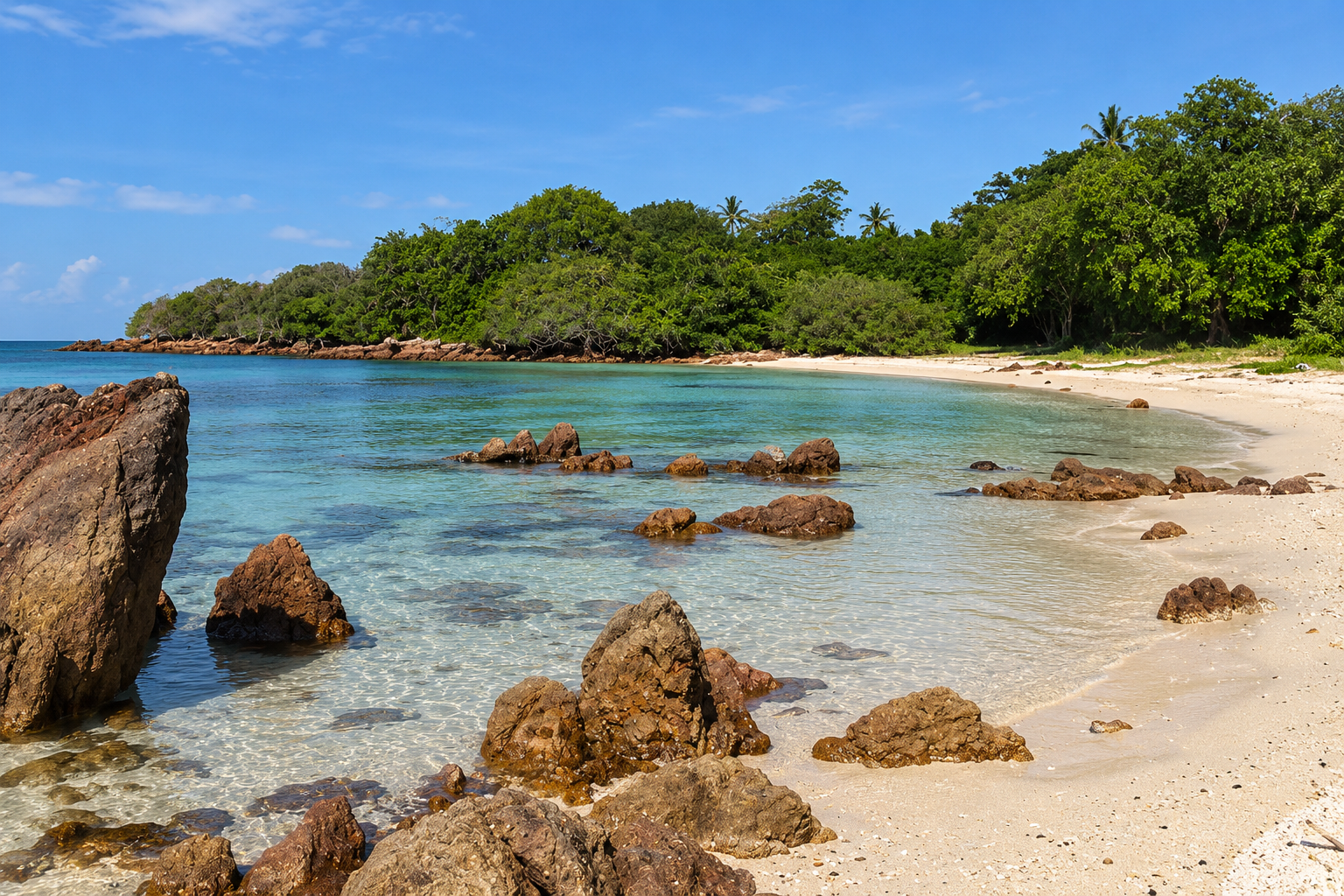
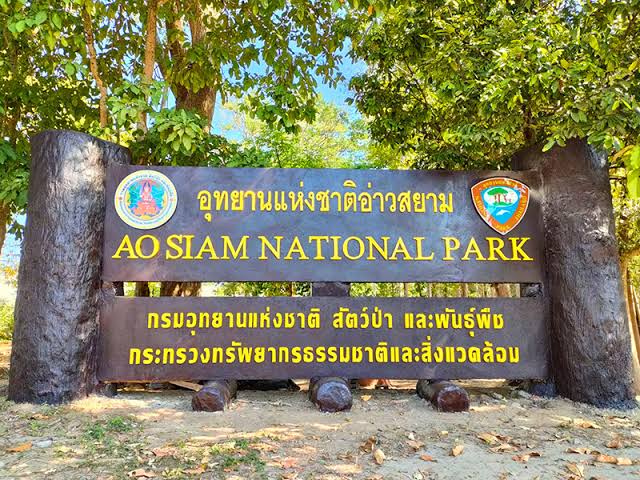
Ao Siam · Prachuap Khiri Khan
Ao Siam National Park
Where Forest Meets the Living Sea
Prachuap Khiri Khan · Gulf of Thailand
A quiet corner of Thailand’s Gulf coast where ancient dipterocarp forests, mangrove wetlands, coral reefs and remote islands come together — and where the endangered hawksbill turtle still returns to nest.
Basic Information
- Name
- Ao Siam National Park
- Thai Name
- อุทยานแห่งชาติอ่าวสยาม
- Official Status
- National Park Preparatory Area
- Province
- Prachuap Khiri Khan
- Districts
- Bang Saphan · Bang Saphan Noi
- Region
- Central Thailand · Gulf Coast
- Sea
- Gulf of Thailand
- Landscape
- Coastal Forest · Mangrove · Beach · Islands · Coral Reefs · Marine Ecosystems
- Preparatory Area
- Approximately 8,021 rai
- Approximate Area
- 12.83 km²
- Main Attractions
- Koh Talu · Ao Thian · Ao Nai Hup · Mae Ramphueng Beach · Khlong Mae Ramphueng Mangrove Forest · Pa Klang Ao
- Best Known For
- Hawksbill Turtles · Koh Talu · Coral Reefs · Ancient Yang Na Forest
A Different Side of Thailand’s Gulf Coast
On the western shore of the Gulf of Thailand, between Bang Saphan and Bang Saphan Noi, lies a landscape that feels remarkably untouched.
Ao Siam brings together several environments within one conservation landscape — dry evergreen forest, coastal forest, mangroves, beaches, coral reefs and offshore islands.
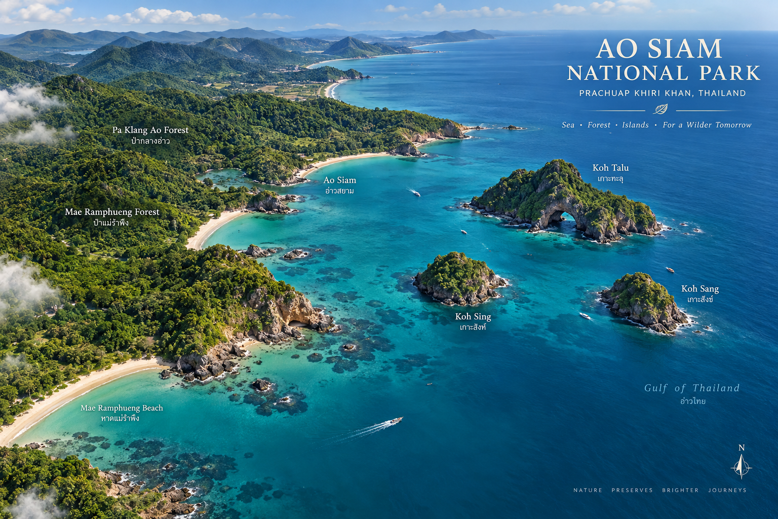
The area includes parts of Pa Klang Ao and Khlong Mae Ramphueng forests on the mainland, together with Koh Talu, Koh Sing and Koh Sang offshore. The Department of National Parks has identified an area of approximately 8,021 rai for the preparation of the national-park designation.
But Ao Siam’s greatest significance may not be what visitors see above the water.
It is what returns to its beaches at night.
The hawksbill turtle.
Why Visit
Why Ao Siam?
- Ancient Forest
- Walk beneath towering Yang Na trees and experience one of the most remarkable remaining lowland forest landscapes in this part of Thailand.
- Hawksbill Turtle Sanctuary
- Koh Talu is an important nesting site for the endangered hawksbill turtle, and the area has recorded significant nesting activity.
- Tropical Islands
- Koh Talu, Koh Sing and Koh Sang extend the conservation landscape into the Gulf of Thailand.
- Coral Reefs
- The surrounding marine environment contains shallow and deeper coral ecosystems that support diverse marine life.
- Mangrove Wetlands
- Khlong Mae Ramphueng supports a productive mangrove ecosystem where freshwater, seawater and coastal wildlife meet.
- Quiet Beaches
- Mae Ramphueng and the coastal areas around Bang Saphan offer a more understated beach experience than Thailand’s major island destinations.
From Ancient Forest to Open Sea
Ao Siam is unusual because its conservation landscape does not stop at the shoreline.
It moves continuously through several ecological zones:
Forest → Coastal Forest → Mangrove → Beach → Reef → Island → Open Gulf
Each environment supports different forms of life.
The result is not simply a collection of attractions.
It is a connected coastal ecosystem.
The Forest of Giant Yang Na Trees
Pa Klang Ao
One of Ao Siam’s most remarkable natural features is Pa Klang Ao.
The forest contains large stands of Yang Na trees, some reaching approximately 30–40 metres in height and estimated to be hundreds of years old.
The Department of National Parks describes the area as one of Thailand’s most important and intact Yang Na forest landscapes. The forest covers more than 1,285 rai, with approximately 600 large Yang Na trees recorded in the area.
Walking beneath these enormous trees creates a completely different experience from the coastal scenery.
The canopy rises high overhead. The forest floor remains relatively cool. And the sound of the sea feels surprisingly distant.
The Island of the Hawksbill Turtle
Koh Talu
Koh Talu is the signature island of Ao Siam.
Located approximately 8 kilometres offshore, the island is known for its dramatic rocky coastline, beaches, coral reefs and an unusual natural arch formed through erosion.
The island stretches roughly north to south and rises to a hill of approximately 90 metres above sea level.
On the western side are several beaches and small bays, while the eastern side features steep rocky cliffs and reef habitat.
But Koh Talu’s greatest importance is ecological.
A Nesting Ground for Hawksbill Turtles
The beaches of Koh Talu are an important nesting area for hawksbill turtles (Eretmochelys imbricata).
The Department of National Parks has described Koh Talu as one of Thailand’s most important hawksbill nesting areas and a particularly significant nesting site on the Gulf coast.
Recent monitoring continues to record successful nesting and hatching.
In October 2025, one monitored nest produced 103 hatchlings from 122 eggs, an 84% survival rate for that nest. Another nest in October 2025 produced 101 hatchlings from 155 eggs.
This is not simply a beautiful island.
It is a functioning wildlife habitat.
Why It’s Called Koh Talu
The island’s name comes from the dramatic natural opening through its northern rock formation.
Over time, waves and wind eroded the limestone and rock, creating a large opening through which visitors can see toward the opposite side.
The result is one of the island’s most recognizable natural features.
Stone, shaped by the sea.
Ao Thian
A Quiet Coastal Corner
Ao Thian is one of the quieter coastal areas associated with Koh Talu.
The landscape combines rocky coastline, forest and open Gulf waters.
Its quieter character makes it particularly interesting for travelers looking beyond the main beach-and-snorkeling experience.
Ao Nai Hup
Where Hawksbills Return
Ao Nai Hup is another important coastal area of Koh Talu and has been documented as a hawksbill nesting location.
The beach becomes particularly significant during nesting season, when conservation teams monitor turtle activity and protect nests.
This is one reason visitors should treat the island not simply as a recreational destination but as a sensitive wildlife habitat.
Life Beneath the Gulf
Coral Reefs
The waters surrounding Ao Siam contain coral reef ecosystems supporting a variety of marine organisms.
Around Koh Talu, snorkeling and diving can reveal:
- Hard corals
- Reef fish
- Marine invertebrates
- Rocky reef habitats
- Shallow-water ecosystems
The marine environment is closely connected to the health of the island’s beaches and coastal forests.
Protecting one means protecting the others.
Where Freshwater Meets the Sea
Mangrove Forest
The Khlong Mae Ramphueng Mangrove Forest is another important component of Ao Siam.
Mangroves form a natural transition between land and sea.
Their complex root systems provide shelter and nursery habitat for:
- Fish
- Crabs
- Mollusks
- Juvenile marine animals
- Coastal birds
This is a very different landscape from Koh Talu.
Instead of open blue water, visitors encounter a maze of roots, mudflats, channels and dense green vegetation.
Mae Ramphueng Beach
The Mainland Coast
Mae Ramphueng is a long sandy beach on the mainland side of Ao Siam.
The beach is known for its relatively peaceful atmosphere and coastal landscape, with road access running along much of the shoreline.
It is a useful starting point for understanding the relationship between the mainland and the offshore conservation areas.
A Refuge for Marine Life
Ao Siam supports a wide range of wildlife because several ecosystems occur in close proximity.
Marine Wildlife
The surrounding Gulf waters support:
- Sea turtles
- Reef fish
- Coral communities
- Crustaceans
- Mollusks
- Other marine organisms
Whale sharks have also been recorded in waters around the area. The Department of National Parks identifies them among important marine wildlife associated with the conservation landscape.
Forest Wildlife
The mainland forests provide habitat for a variety of terrestrial species.
The combination of old-growth trees, coastal vegetation and wetlands creates ecological connectivity between different habitats.
The Symbol of Ao Siam
Hawksbill Turtles
If there is one animal that defines the conservation story of Ao Siam, it is the hawksbill turtle.
The species is endangered and has experienced severe population declines globally.
Ao Siam is particularly important because the turtles continue to return to its beaches to lay their eggs.
The nesting process usually takes place at night. A female turtle emerges from the sea. She searches for a suitable section of beach. Then, slowly and carefully, she digs a nest and lays her eggs before returning to the ocean.
For the visitor, this is not a spectacle.
It is a moment that should be observed quietly and responsibly.
A National Park in the Making
Ao Siam is an important example of Thailand’s continuing effort to expand and strengthen protected natural areas.
The Department of National Parks began the process of preparing the area for national-park designation, covering mainland forest areas around Mae Ramphueng and Pa Klang Ao together with parts of Koh Talu, Koh Sing and Koh Sang.
Public participation in the designation process was formally opened in 2023.
As of 2026, the Department continues to refer to the area as Ao Siam National Park (Preparatory).
Why This Matters
Ao Siam is not simply being protected because it is beautiful.
It is being protected because the landscape contains:
Old forest + wetlands + beaches + reefs + islands + endangered wildlife
within one connected conservation system.
Conservation With Local People
Ao Siam’s conservation work increasingly involves local communities.
In 2026, the park worked with local fishermen and community networks to deploy traditional “sang kor” fish shelters, creating habitat for juvenile marine life and supporting coastal ecosystem recovery.
This represents an important principle:
Conservation does not have to mean separating people from nature.
In Ao Siam, local communities are part of the management story.
What to Experience
- Forest Walk
- Explore the Yang Na forest at Pa Klang Ao and experience the scale of the old trees.
- Mangrove Exploration
- Follow the mangrove ecosystem around Khlong Mae Ramphueng.
- Island Exploration
- Travel to Koh Talu and explore its beaches, rocky formations and natural arch.
- Snorkeling
- Discover the coral and marine life surrounding the offshore islands.
- Nature Photography
- Ao Siam offers a rare combination of forest, beach, reef and wildlife photography within one destination.
- Turtle Conservation
- During the nesting season, visitors may encounter conservation activities related to hawksbill turtles, subject to park regulations and access restrictions.
A Photographer’s Ao Siam
- Forest
- Shoot upward beneath the enormous Yang Na canopy.
- Island
- Use the natural arch and limestone formations as the visual anchor.
- Marine
- Capture reef life beneath clear Gulf waters.
- Wildlife
- Photograph turtles and other wildlife only from a respectful distance.
- Landscape
- Use the transition from forest to sea to tell the story of the destination.
When to Go
The Gulf coast has a different weather pattern from Thailand’s Andaman coast.
For outdoor activities, island trips and snorkeling, conditions can vary considerably with the monsoon and sea state.
The official closure schedule is particularly important for Koh Talu and selected facilities.
For the current published closure schedule, Koh Talu, the beach-forest nature trail and camping area are scheduled to close from 1 November to 15 December.
Because weather, sea conditions and conservation measures can change, visitors should check the park’s latest announcement before traveling.
Visitor Information
General visitor access: 08:30–16:30 daily
Ao Siam is a preparatory national-park area with different mainland and island components. Access can depend on seasonal closures, sea conditions, conservation operations, turtle nesting activity, boat arrangements and local restrictions.
For Koh Talu in particular, access should be checked before departure.
Seasonal Closure
According to the Department of National Parks’ published closure schedule, the following are scheduled for seasonal closure:
- Koh Talu
- Beach Forest Nature Study Trail
- Camping Area
1 November – 15 December
The purpose is related to seasonal conditions, resource recovery and visitor safety.
Always check the latest DNP announcement before visiting.
How to Reach Ao Siam
Ao Siam is located in Prachuap Khiri Khan Province, around the Bang Saphan and Bang Saphan Noi districts.
Mainland Areas
Pa Klang Ao and Mae Ramphueng can be reached by road from the Bang Saphan area.
Koh Talu
Koh Talu is an offshore island approximately 8 kilometres from the mainland.
Boat services normally connect the island with the mainland coast.
Travel time and departure points depend on local operators and sea conditions.
Who Is Ao Siam For?
- Nature Lovers
- For travelers who want to see ecosystems rather than simply beaches.
- Wildlife Enthusiasts
- Especially those interested in sea turtles and marine conservation.
- Divers & Snorkelers
- The offshore reefs provide opportunities to explore Gulf marine life.
- Photographers
- The combination of ancient forest, islands and marine landscapes offers strong visual variety.
- Slow Travelers
- Ao Siam rewards travelers who take time to understand the landscape rather than rushing between attractions.
Before You Go
Bring
- Reef-safe sun protection
- Drinking water
- Hat
- Comfortable walking shoes
- Dry bag
- Snorkeling equipment if needed
- Waterproof phone protection
Remember
- Do not touch coral
- Do not collect shells or marine life
- Do not feed wildlife
- Keep beaches clean
- Avoid disturbing turtle nests
- Follow instructions from park officers
- Check sea conditions before taking a boat
- Respect seasonal closures
If You See a Turtle
Responsible Wildlife Viewing
A nesting turtle should never be treated like a tourist attraction.
- Keep your distance
- Keep noise to a minimum
- Do not use flash photography unless specifically permitted
- Do not touch the turtle
- Do not block its route between the beach and the sea
Let the turtle behave as if nobody is there.
Continue Exploring Prachuap Khiri Khan
- Bang Saphan
- A relaxed coastal town and useful base for exploring the southern part of the province.
- Bang Saphan Noi
- The gateway area for Koh Talu and the offshore islands.
- Ban Krut
- A quiet Gulf coast destination known for its long beach and relaxed atmosphere.
- Ao Thonglang
- A scenic coastal area north of Bang Saphan.
- Khao Sam Roi Yot National Park
- One of Thailand’s most distinctive coastal national parks, famous for limestone mountains, wetlands and Phraya Nakhon Cave.
Quick Facts
- Province
- Prachuap Khiri Khan
- Districts
- Bang Saphan · Bang Saphan Noi
- Region
- Central Thailand · Gulf Coast
- Status
- National Park Preparatory Area
- Preparatory Area
- Approx. 8,021 rai
- Landscape
- Forest · Mangrove · Beach · Island · Coral Reef · Marine Ecosystem
- Mainland Highlights
- Pa Klang Ao · Mae Ramphueng Beach · Khlong Mae Ramphueng
- Island Highlights
- Koh Talu · Koh Sing · Koh Sang
- Wildlife Highlight
- Hawksbill Turtle
- Signature Experience
- Koh Talu · Snorkeling · Forest Walk · Wildlife Conservation
- General Visitor Hours
- 08:30–16:30
- Seasonal Closure
- Koh Talu / Beach Forest Trail / Camping: 1 November–15 December
Location
Find Ao Siam National Park
Bang Saphan · Bang Saphan Noi, Prachuap Khiri Khan, Thailand